I am a volcano seismologist who is focused on improving the way we recognize, monitor, and respond to volcanic unrest. I use and develop new tools to rapidly detect and better understand seismic signals generated by volcanoes such as earthquake swarms and tremor.
I have two roles at the California Volcano Observatory (CalVO): fundamental science research on volcanic seismicity and monitoring of California’s volcanoes. My research focuses on understanding physical processes at volcanoes through the entire cycle of eruption and repose using a variety of seismological methods.
Major themes in my research are:
- Recognition of unrest and changes in eruptive character
- Genesis of earthquake swarms and volcanic tremor
- Integration of interdisciplinary geophysical and geological datasets into seismic interpretations
The methods I use include waveform cross-correlation and clustering, precise relative relocation, coda wave interferometry, spectral analysis, and machine learning, among many others. I enjoy working on eruption datasets and often revisit older data to find new and unexpected observations that supplement our knowledge of what occurred and why.
I develop software for improving the way we seismically monitor volcanoes by bringing ideas from the literature into production for routine monitoring. I'm interested in the integration of interactive and automated data display so scientists responding to crises spend less time assembling data and more time interpreting it.
I lead the monitoring team at CalVO, and work with the Northern California Seismic Network to keep California’s volcanoes under constant surveillance. My goal is to ensure the necessary equipment and monitoring capabilities are already in place when the next Californian eruption occurs. I also assist other USGS volcano observatories and the Volcano Disaster Assistance Program with capacity building, data analysis, and eruption response assistance.
My interest in volcanoes began at a young age, and my career made possible through the support and mentorship of USGS scientists. As a result, I believe strongly in the value of both public outreach and mentoring for students and early career researchers.
Professional Experience
2020-Present: Research Geophysicist, USGS California Volcano Observatory
2016-2020: USGS Mendenhall Postdoctoral Fellow, Volcano Science Center
2014-2016: Postdoctoral Researcher, Department of Earth and Space Sciences, University of Washington
2009-2016: Duty Seismologist, Pacific Northwest Seismic Network
2009-2014: Research Assistant, Department of Earth and Space Sciences, University of Washington
2010: Research Geophysicist, USGS Alaska Volcano Observatory
2004-2009: Physical Science Technician / Geophysicist, USGS National Earthquake Information Center
Education and Certifications
Doctor of Philosophy, Earth and Space Science: 2014, University of Washington, Seattle, WA
Master of Science, Geophysics: 2009, Colorado School of Mines, Golden, CO
Bachelor of Science, Geophysical Engineering: 2007, Magna Cum Laude, Colorado School of Mines, Golden, CO
Affiliations and Memberships*
Seismological Society of America
American Geophysical Union
International Association of Volcanoes and Chemistry of the Earth's Interior
Honors and Awards
David A. Johnston Award for Research Excellence, University of Washington, 2014
College of the Environment Dean’s Graduate Medalist, University of Washington, 2014
AGU Outstanding Student Paper Award (VGP Section), 2011
AGU Outstanding Student Paper Award (VGP Section), 2010
Cecil and Ida Green Award in Geophysics, Colorado School of Mines, 2007
Magna Cum Laude, Colorado School of Mines, 2007
John Moore Endowed Scholarship, Colorado School of Mines, 2003-2007
Science and Products
Time series of seismic velocity changes during the 2018 collapse of Kīlauea volcano derived from coda wave interferometry of repeating earthquakes
Ring fault creep drives volcano-tectonic seismicity during caldera collapse of Kīlauea in 2018
Volcanic earthquake catalog enhancement using integrated detection, matched-filtering, and relocation tools
Trends in volcano seismology: 2010 to 2020 and beyond
Earthquake-derived seismic velocity changes during the 2018 caldera collapse of Kīlauea volcano
Seismic and geodetic progression of the 2018 summit caldera collapse of Kīlauea Volcano
Deep fluid pathways beneath Mammoth Mountain, California, illuminated by migrating earthquake swarms
Non-USGS Publications**
Thelen, W.A., Hotovec-Ellis, A.J., and Bodin, P., 2016. Feasibility study of earthquake early warning (EEW) in Hawaiʻi. U.S. Geological Survey Open-File Report 2016-1172, 33 p., http://dx.doi.org/10.3133/ofr20161172.
**Disclaimer: The views expressed in Non-USGS publications are those of the author and do not represent the views of the USGS, Department of the Interior, or the U.S. Government.
REDPy - Repeating Earthquake Detector in Python (Version 1.0.0)
Science and Products
- Data
Time series of seismic velocity changes during the 2018 collapse of Kīlauea volcano derived from coda wave interferometry of repeating earthquakes
These processed data and provisional codes were created to investigate seismic velocity changes associated with the collapse of Kīlauea caldera during its 2018 eruption. Primary data (i.e., seismic waveforms) are hosted at the Incorporated Research Institutions for Seismology (IRIS; https://www.iris.edu/) and are ingested by the codes included here to reproduce the data analyzed in Hotovec-Ellis e - Multimedia
- Publications
Ring fault creep drives volcano-tectonic seismicity during caldera collapse of Kīlauea in 2018
Basaltic caldera collapses are episodic, producing very-long-period (VLP) earthquakes up to Mw 5.4, with prolific inter-collapse (between collapses) volcano-tectonic (VT) seismicity. During the 2018 caldera collapse of Kīlauea Volcano, VT seismicity ceased following each collapse, and then accelerated to a quasi-steady rate prior to the next collapse, marking a temporal pattern distinct from typicAuthorsTaiyi A. Wang, Paul Segall, Alicia J. Hotovec-Ellis, Kyle R. Anderson, Peter F. CervelliVolcanic earthquake catalog enhancement using integrated detection, matched-filtering, and relocation tools
Volcanic earthquake catalogs are an essential data product used to interpret subsurface volcanic activity and forecast eruptions. Advances in detection techniques (e.g., matched-filtering, machine learning) and relative relocation tools have improved catalog completeness and refined event locations. However, most volcano observatories have yet to incorporate these techniques into their catalog-buiAuthorsDarren Tan, David Fee, Alicia J. Hotovec-Ellis, J. Pesicek, Matthew M. Haney, John Power, T. GironaTrends in volcano seismology: 2010 to 2020 and beyond
Volcano seismology has been fundamental to our current understanding of crustal magma migration and eruption. The increasing availability of portable seismic networks with the creative use of seismic sources and ambient noise has led to a better understanding of the volcanic structure of many volcanoes and is producing increasingly detailed images of the volcanic subsurface. The past decade (2010-AuthorsWeston Thelen, Robin Matoza, Alicia J. Hotovec-EllisEarthquake-derived seismic velocity changes during the 2018 caldera collapse of Kīlauea volcano
The 2018 Kīlauea caldera collapse produced extraordinary sequences of seismicity and deformation, with 62 episodic collapse events which significantly altered the landscape of the summit region. Despite decades of focused scientific studies at Kīlauea, detailed information about the internal structure of the volcano is limited. Recently developed techniques in seismic interferometry can be used toAuthorsAlicia J. Hotovec-Ellis, Brian Shiro, David R. Shelly, Kyle R. Anderson, Matt Haney, Weston Thelen, Emily Montgomery-Brown, Ingrid JohansonSeismic and geodetic progression of the 2018 summit caldera collapse of Kīlauea Volcano
The 2018 eruption of Kīlauea volcano, Hawaiʻi, resulted in a major collapse of the summit caldera along with an effusive eruption in the lower East Rift Zone. The caldera collapse comprised 62 highly similar collapse cycles of strong ground deformation and earthquake swarms that ended with a magnitude 5 collapse event and one partial cycle that did not end with a collapse event. We analyzed geodetAuthorsGabrielle Tepp, Alicia J. Hotovec-Ellis, Brian Shiro, Ingrid Johanson, Weston Thelen, Matthew M. HaneyDeep fluid pathways beneath Mammoth Mountain, California, illuminated by migrating earthquake swarms
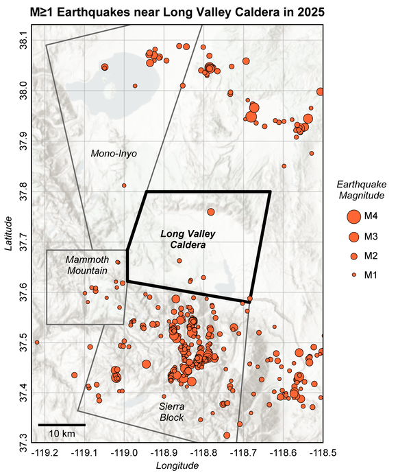
Although most volcanic seismicity is shallow (within several kilometers of the surface), some volcanoes exhibit deeper seismicity (10 to 30+ km) that may reflect active processes such as magma resupply and volatile transfer. One such volcano is Mammoth Mountain, California, which has also recently exhibited high rates of CO2 discharge at the surface. We perform high-resolution earthquake detectionAuthorsAlicia J. Hotovec-Ellis, David R. Shelly, David P. Hill, Andrew M. Pitt, Phillip B. Dawson, Bernard A. ChouetNon-USGS Publications**
Hotovec-Ellis, A.J., Bodin, P., Thelen, W., Okubo, P., and Vidale, J.E., 2017. Improving the Hawaiian Seismic Network for Earthquake Early Warning, Seism. Res. Lett., 88, pp. 326-334, doi:10.1785/0220160187.
Thelen, W.A., Hotovec-Ellis, A.J., and Bodin, P., 2016. Feasibility study of earthquake early warning (EEW) in Hawaiʻi. U.S. Geological Survey Open-File Report 2016-1172, 33 p., http://dx.doi.org/10.3133/ofr20161172.
Hotovec-Ellis, A. J., Vidale, J. E., Gomberg, J., Thelen, W., and Moran, S. C., 2015. Changes in seismic velocity during the first 14 months of the 2004–2008 eruption of Mount St. Helens, Washington, J. Geophys. Res., 120, pp. 6226-6240, doi:10.1002/2015JB012101.Haney, M., Hotovec-Ellis, A.J., Bennington, N.L., De Angelis, S., and Thurber, C., 2015. Tracking changes in volcanic systems with seismic interferometry, in Encyclopedia of Earthquake Engineering, edited by M. Beer et al., pp. 1-23, Springer, doi:10.1007/978-3-642-36197-5_50-1.Hotovec-Ellis, A.J., Gomberg, J.S., Vidale, J.E., and Creager, K.C., 2014. A continuous record of inter-eruption velocity change at Mount St. Helens from coda-wave interferometry, J. Geophys. Res., 119, pp. 2199–2214, doi:10.1002/2013JB010742.Vidale, J.E., Malone, S.D., Hotovec-Ellis, A.J., Moran, S.C., Creager, K.C., Houston, H., and Schmidt, D.A., 2013. Deep long-period earthquakes west of the volcanic arc in Oregon: Direct evidence of fluid migration through the forearc mantle wedge, Geophys. Res. Lett., pp. 370-376, doi:10.1002/2013GL059118.Dmetrieva, K., Hotovec-Ellis, A.J., Prejean, S.G., and Dunham, E.M., 2013. Frictional faulting model for silenced harmonic tremor prior to Redoubt Volcano eruptions. Nature Geoscience 6(8), pp. 652-656, doi:10.1038/ngeo1879.Hotovec, A.J., Prejean, S.G., Vidale, J.E., and Gomberg, J.S., 2013. Strongly Gliding Harmonic Tremor During the 2009 Eruption of Redoubt Volcano. J. Volcan. Geotherm. Res. (Redoubt Special Issue) 259, pp. 89-99, doi:10.1016/jvolgeores.2012.01.001.Gomberg, J., Creager, K., Sweet, J., Vidale, J., Ghosh, A., and Hotovec, A., 2012. Earthquake spectra and near-source attenuation in the Cascadia subduction zone. J. Geophys. Res. 117, B05312, 12 p., doi:10.1029/2011JB009055.Vidale, J.E., Hotovec, A.J., Ghosh, A., Creager, K.C., and Gomberg, J.S., 2011. Tiny intraplate earthquakes triggered by nearby episodic tremor and slip in Cascadia. Geochem. Geophys. Geosyst. 12(6), Q06005, 8 p., doi:10.1029/2011GC003559.Allen, T.I., Wald, D.J., Earle, P.S., Marano, K.D., Hotovec, A.J., Lin, K., and Hearne, M., 2009. An Atlas of ShakeMaps and population exposure catalog for earthquake loss modeling. Bull. Earthq. Eng. 7(3), pp. 701-718, doi: 10.1007/s10518-009-9120-y.Earle, P.S, Wald, D.J., Jaiswal, K.S., Allen, T.I., Marano, K.D., Hotovec, A.J., Hearne, M.G., and Fee. J.M., 2009. Prompt Assessment of Global Earthquakes for Response (PAGER): A system for rapidly determining the impact of earthquakes worldwide. U.S. Geological Survey Open-File Report 2009-1131, 15 p.Allen, T.I., Wald, D.J., Hotovec, A.J., Lin, K., Earle, P.S., and Marano, K.D., 2008. An Atlas of ShakeMaps for selected global earthquakes. U.S. Geological Survey Open-File Report 2008-1236, 47 p. 2008**Disclaimer: The views expressed in Non-USGS publications are those of the author and do not represent the views of the USGS, Department of the Interior, or the U.S. Government.
- Software
REDPy - Repeating Earthquake Detector in Python (Version 1.0.0)
REDPy (Repeating Earthquake Detector in Python) is a tool for automated detection and analysis of repeating earthquakes in continuous data. It works without any previous assumptions of what repeating seismicity looks like (that is, does not require a template event). Repeating earthquakes are clustered into families based on waveform similarity via cross-correlation across multiple stations. All d - News
*Disclaimer: Listing outside positions with professional scientific organizations on this Staff Profile are for informational purposes only and do not constitute an endorsement of those professional scientific organizations or their activities by the USGS, Department of the Interior, or U.S. Government