
Jeff Conaway
Surface-water modeling, sediment transport, acoustic Doppler current profilers
Science and Products
Filter Total Items: 26

Taku River
Adverse water quality from a trio of historic mines in the Tulsequah River watershed, a tributary of the Taku River, have caused concern in local communities including Juneau, Alaska, and Atlin, British Columbia

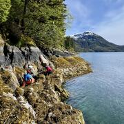
Salmon River
The Salmon River, located near Hyder, Alaska, and Stewart, British Columbia, is the smallest watershed in the transboundary study of Southeast Alaska.
Q&A: USGS Ecosystems Provides Objective Science to Manage Lands, Fish, and Wildlife
The USGS Ecosystems Mission Area is the only program within the Department of Interior (DOI) focused on generating science to inform the management of the nation’s lands, fish, and wildlife. The Ecosystems Mission Area is also the only entity with the specific role of meeting the information needs of DOI agencies (e.g., Bureau of Land Management, Bureau of Ocean Energy Management, National Park...

Q&A: The Role of USGS Ecosystems Science in Alaska
The USGS is the science arm of the Department of the Interior (DOI) with a mission to provide timely and impartial science information to decision-makers, industry, and others. Topics of USGS research and monitoring in Alaska include Ecosystems, Energy and Minerals, Geology, Water Resources, and Natural Hazards. At the Ecosystems Office of the USGS Alaska Science Center, research and monitoring...

Q&A: USGS Ecosystems Science Provides Information on Subsistence and Hunter-Harvested Food Resources in Alaska
The USGS is the science arm of the Department of the Interior with a mission to provide timely and impartial science information to decision-makers, industry, tribal entities and others. In Alaska, subsistence and hunter-harvested foods are kitchen table issues for the public. The annual subsistence harvest per rural resident is 295 pounds of wild food. USGS science is responsive to subsistence...

Q&A: USGS and the 2025 Anchorage Bike to Work Day
For the May 16, 2025, Anchorage Bike to Work Day, the USGS Alaska Science Center will again host a station along the Lanie Fleischer Chester Creek Trail where people can learn about the USGS streamgage on the creek and about the common birds of Chanshtnu. Chester Creek or Chanshtnu, which means ‘grass creek’ in the Dena’ina language, runs for about 20 miles from the Chugach mountains in the...
Science and Products
Filter Total Items: 26
Taku River
Adverse water quality from a trio of historic mines in the Tulsequah River watershed, a tributary of the Taku River, have caused concern in local communities including Juneau, Alaska, and Atlin, British Columbia
Salmon River
The Salmon River, located near Hyder, Alaska, and Stewart, British Columbia, is the smallest watershed in the transboundary study of Southeast Alaska.
Q&A: USGS Ecosystems Provides Objective Science to Manage Lands, Fish, and Wildlife
The USGS Ecosystems Mission Area is the only program within the Department of Interior (DOI) focused on generating science to inform the management of the nation’s lands, fish, and wildlife. The Ecosystems Mission Area is also the only entity with the specific role of meeting the information needs of DOI agencies (e.g., Bureau of Land Management, Bureau of Ocean Energy Management, National Park...
Q&A: The Role of USGS Ecosystems Science in Alaska
The USGS is the science arm of the Department of the Interior (DOI) with a mission to provide timely and impartial science information to decision-makers, industry, and others. Topics of USGS research and monitoring in Alaska include Ecosystems, Energy and Minerals, Geology, Water Resources, and Natural Hazards. At the Ecosystems Office of the USGS Alaska Science Center, research and monitoring...
Q&A: USGS Ecosystems Science Provides Information on Subsistence and Hunter-Harvested Food Resources in Alaska
The USGS is the science arm of the Department of the Interior with a mission to provide timely and impartial science information to decision-makers, industry, tribal entities and others. In Alaska, subsistence and hunter-harvested foods are kitchen table issues for the public. The annual subsistence harvest per rural resident is 295 pounds of wild food. USGS science is responsive to subsistence...
Q&A: USGS and the 2025 Anchorage Bike to Work Day
For the May 16, 2025, Anchorage Bike to Work Day, the USGS Alaska Science Center will again host a station along the Lanie Fleischer Chester Creek Trail where people can learn about the USGS streamgage on the creek and about the common birds of Chanshtnu. Chester Creek or Chanshtnu, which means ‘grass creek’ in the Dena’ina language, runs for about 20 miles from the Chugach mountains in the...