
The USGS is the science arm of the Department of the Interior (DOI) with a mission to provide timely and impartial science information to decision-makers, industry, and others.
Topics of USGS research and monitoring in Alaska include Ecosystems, Energy and Minerals, Geology, Water Resources, and Natural Hazards. At the Ecosystems Office of the USGS Alaska Science Center, research and monitoring informs industry and management activities of other DOI bureaus.
Return to USGS Alaska Q&A Series
Alaska has significant natural resources and energy development activities. Additionally, over 60% of land in Alaska is managed by federal agencies, such as the Bureau of Land Management, the U.S. Fish and Wildlife Service, the National Park Service, and the Bureau of Ocean Energy Management. The USGS is non-regulatory and does not advocate for or recommend management actions. Instead, USGS works with partners to determine critical science needed for emerging topics and ongoing decisions and produce timely and impartial information.
Importantly, USGS studies, data, analytical code, and findings are governed by the USGS Fundamental Science Practices, a set of guidelines and requirements for conducting science and releasing data and information through a formal peer review process. This provides transparency and objectivity.
In this Q&A, we provide examples of recent and ongoing critical information for industry and management agencies that are being produced by the USGS Ecosystems Office in Alaska and that assist Executive and Department of Interior Secretarial orders and priorities.
Unleashing Alaska's Extraordinary Resource Potential
Q: What are some examples of USGS Ecosystems science in Alaska that contribute to Executive Order 14153 and Secretarial Order 3422 “Unleashing Alaska's Extraordinary Resource Potential”?
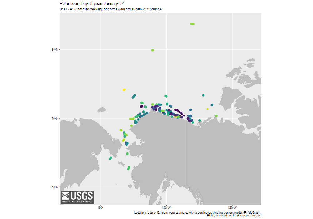
Identifying the distribution and timing of polar bear maternal denning in areas of oil and gas infrastructure to support human safety and minimize bear disturbance
- The USGS has tracked the locations of polar bears on the North Slope of Alaska for over 30 years, providing a long-term data set of den locations of pregnant females during the winter. Den locations and changes in den distribution over time is critical information for mitigation of bear-human conflict and minimizing disturbance to polar bears and cubs.
- These data have identified that twice as many female polar bears now den on land on the North Slope of Alaska than did in the past, that this trend is likely to continue, and that the majority of polar bear denning occurs where most oil and gas activity occurs. These data have also allowed industry and partners to develop maps of likely locations of polar bear dens for their operations.
Determining trends in the number of polar bears summering on the North Slope of Alaska to reduce bear-human conflicts near industry and local communities
- USGS collected extensive radio-collar data over three decades and examined trends in land use by polar bears in the southern Beaufort Sea and Chukchi Sea where bears have traditionally spent most of the year on the sea ice.
- The proportion of bears summering onshore and their duration onshore was correlated with the percent of open water that occurred between July and October. As sea ice declined, the percent of bears summering onshore increased.
- The USGS estimated that greater than 50% of bears will spend over 100 days onshore during summer by 2040. These increases in polar bear land occupancy puts more bears in proximity to human activities for longer durations than in the past and extends the lack of access for bears to their primary prey (seals).

Unleashing Alaska's Extraordinary Resource Potential Cont'd
Monitoring the movements, size, and location of a herd of up to 190,000 Pacific walruses on the northwest coast of Alaska using satellite imagery to reduce conflicts with vessel traffic
- Pacific walruses have historically occupied sea ice during the summer months but since approximately 2007, they now form large haulouts on the northwest coast of Alaska. The USGS has partnered with several Earth observing imagery companies to identify the timing of arrival and departure of walruses onshore and estimate abundance.
- USGS data of walrus haulouts are often released with real-time position information so that marine vessels can navigate safely and with minimal disturbance to walruses.

Unleashing Alaska's Extraordinary Resource Potential Cont'd
Mapping current and future use areas of northern caribou herds in Alaska
- USGS found that female caribou exhibited avoidance to industrial infrastructure during the summer. The strongest responses occurred during the calving season and then waned later in the summer. USGS also studied vehicle traffic within North Slope oil fields and found that caribou were less like to cross roads with higher traffic volumes and that they reduced their use of habitat near roads with higher traffic.
- USGS determined how the timing of spring snow melt and vegetation growth effects the current and potential future migratory patterns of the Porcupine Caribou Herd, which shifts its distributions across the U.S.– Canadian border each year. In years with early springs, caribou predominately used habitat in Alaska for calving, while in years with late spring, they spent more time in Canada. Future climate conditions are expected to have more early springs, shifting caribou calving and post-calving distributions further west into Alaska.
- USGS has work underway to assess the effectiveness of mitigation measures to reduce impacts of energy development on caribou movements and habitat use.
These findings can assist the planning and placement of future industrial developments in the coastal plain of Alaska.

Unleashing Alaska's Extraordinary Resource Potential Cont'd
Providing maps on the abundance and distribution of fish species that are critical to fisheries management in Alaska
- The USGS maintains the Alaska Forage Fish Database (AFFD) which provides the Bureau of Ocean and Energy Management with data needed for planning for energy development in the Alaska Outer Continental Shelf Region. The AFFD contains information on over 40 fish species and invertebrates sampled from more than 461,000 sampling events and is a powerful tool for examining trends and distribution of fish.

Reducing Spending and Inefficiencies in the Government
Q: What are some examples of USGS Ecosystems science in Alaska that have reduced spending and inefficiencies in the government?
Development of less costly and more precise methods for decision makers
- The USGS helped to develop better surveys for determining population size of the Pacific black brant in Alaska using aerial photography as an alternative to an expensive winter survey, flown over 3,500 miles of Pacific coast. Additionally, the new surveys identified that the winter population size is roughly twice that estimated from the previous, intensive survey approach. The U.S. Fish and Wildlife Service has since switched to using this aerial imagery survey to monitor the Pacific black brant population and inform harvest management.
- Highly pathogenic avian influenza (HPAI) spread to North America in late 2021. The USGS has monitored the status of HPAI in Alaska for over a decade and has detected the virus in numerous wild birds and mammals. USGS continues to monitor avian influenza virus introductions into Alaska – a pathway for introductions into the United States – and provides this situational awareness to partners and the public.
- The USGS has developed statistical models that leverage tracking data to improve efficiency of wildlife population monitoring and can reduce the need for some costly and logistically challenging field efforts. For example, GPS tracking data can now be used to better understand the annual breeding success of many species of management concern that breed in remote areas, such as the golden eagle and California condor. Further, tracking data can now be used to better understand spatial patterns in animal survival and mortality risk, information that is key to responsibly managing wildlife but is often otherwise difficult and costly to collect.

Science that Informs DOI of Emerging Issues
Q: What are some examples of USGS Ecosystems science that inform DOI of emerging issues?
Detection of natural resource challenges that can impact economies and communities
- Recent observations from across Arctic Alaska indicate that waters draining permafrost landscapes are mobilizing iron, carbon, and other heavy metals due to ground thaw. This ground ice thaw is leading to abrupt changes in the color of 75 streams from their normal color to a bright orange. Along with this color change is a shift in water quality, including higher acidity and turbidity, and higher concentrations of sulfate, iron, and trace metals (e.g., zinc, nickel). Stream discoloration has also been associated with declines in the abundance of macroinvertebrates and fish. These findings may have implications for drinking water supplies and fisheries.
- USGS monitors the prevalence of avian influenza for 30 waterfowl species across the continental U.S. USGS found that areas of high virus prevalence were related to regional duck density, with highest predicted prevalence found across the upper Midwest during early fall. These findings are useful for identifying areas of probable viral spillover from wild birds to poultry and to mitigate the risks of avian influenza outbreaks among domestic birds and human populations.
- Salmon are a critical commercial and subsistence resource in the State of Alaska. In 2021 and 2022, western Alaska salmon abundance declined to the lowest levels observed in 30 years. Declines have profound effects on commercial fisheries and indigenous communities. The USGS helped to synthesize perspectives on salmon declines in western Alaska, review available data for addressing current questions, and determine the perspectives of partners, fisheries management, and community members.
- Pathogens in wildlife can affect species health and can potentially be transmitted to humans, particularly for harvested species. The USGS has examined changes in pathogen exposure across decades of sampling and for multiple species, including polar bears, red fox, and migratory birds.


Exploring Alaska Through Our Science
The USGS is the science arm of the Department of the Interior (DOI) with a mission to provide timely and impartial science information to decision-makers, industry, and others.
Topics of USGS research and monitoring in Alaska include Ecosystems, Energy and Minerals, Geology, Water Resources, and Natural Hazards. At the Ecosystems Office of the USGS Alaska Science Center, research and monitoring informs industry and management activities of other DOI bureaus.
Return to USGS Alaska Q&A Series
Alaska has significant natural resources and energy development activities. Additionally, over 60% of land in Alaska is managed by federal agencies, such as the Bureau of Land Management, the U.S. Fish and Wildlife Service, the National Park Service, and the Bureau of Ocean Energy Management. The USGS is non-regulatory and does not advocate for or recommend management actions. Instead, USGS works with partners to determine critical science needed for emerging topics and ongoing decisions and produce timely and impartial information.
Importantly, USGS studies, data, analytical code, and findings are governed by the USGS Fundamental Science Practices, a set of guidelines and requirements for conducting science and releasing data and information through a formal peer review process. This provides transparency and objectivity.
In this Q&A, we provide examples of recent and ongoing critical information for industry and management agencies that are being produced by the USGS Ecosystems Office in Alaska and that assist Executive and Department of Interior Secretarial orders and priorities.
Unleashing Alaska's Extraordinary Resource Potential
Q: What are some examples of USGS Ecosystems science in Alaska that contribute to Executive Order 14153 and Secretarial Order 3422 “Unleashing Alaska's Extraordinary Resource Potential”?
Identifying the distribution and timing of polar bear maternal denning in areas of oil and gas infrastructure to support human safety and minimize bear disturbance
- The USGS has tracked the locations of polar bears on the North Slope of Alaska for over 30 years, providing a long-term data set of den locations of pregnant females during the winter. Den locations and changes in den distribution over time is critical information for mitigation of bear-human conflict and minimizing disturbance to polar bears and cubs.
- These data have identified that twice as many female polar bears now den on land on the North Slope of Alaska than did in the past, that this trend is likely to continue, and that the majority of polar bear denning occurs where most oil and gas activity occurs. These data have also allowed industry and partners to develop maps of likely locations of polar bear dens for their operations.
Determining trends in the number of polar bears summering on the North Slope of Alaska to reduce bear-human conflicts near industry and local communities
- USGS collected extensive radio-collar data over three decades and examined trends in land use by polar bears in the southern Beaufort Sea and Chukchi Sea where bears have traditionally spent most of the year on the sea ice.
- The proportion of bears summering onshore and their duration onshore was correlated with the percent of open water that occurred between July and October. As sea ice declined, the percent of bears summering onshore increased.
- The USGS estimated that greater than 50% of bears will spend over 100 days onshore during summer by 2040. These increases in polar bear land occupancy puts more bears in proximity to human activities for longer durations than in the past and extends the lack of access for bears to their primary prey (seals).
Unleashing Alaska's Extraordinary Resource Potential Cont'd
Monitoring the movements, size, and location of a herd of up to 190,000 Pacific walruses on the northwest coast of Alaska using satellite imagery to reduce conflicts with vessel traffic
- Pacific walruses have historically occupied sea ice during the summer months but since approximately 2007, they now form large haulouts on the northwest coast of Alaska. The USGS has partnered with several Earth observing imagery companies to identify the timing of arrival and departure of walruses onshore and estimate abundance.
- USGS data of walrus haulouts are often released with real-time position information so that marine vessels can navigate safely and with minimal disturbance to walruses.
Unleashing Alaska's Extraordinary Resource Potential Cont'd
Mapping current and future use areas of northern caribou herds in Alaska
- USGS found that female caribou exhibited avoidance to industrial infrastructure during the summer. The strongest responses occurred during the calving season and then waned later in the summer. USGS also studied vehicle traffic within North Slope oil fields and found that caribou were less like to cross roads with higher traffic volumes and that they reduced their use of habitat near roads with higher traffic.
- USGS determined how the timing of spring snow melt and vegetation growth effects the current and potential future migratory patterns of the Porcupine Caribou Herd, which shifts its distributions across the U.S.– Canadian border each year. In years with early springs, caribou predominately used habitat in Alaska for calving, while in years with late spring, they spent more time in Canada. Future climate conditions are expected to have more early springs, shifting caribou calving and post-calving distributions further west into Alaska.
- USGS has work underway to assess the effectiveness of mitigation measures to reduce impacts of energy development on caribou movements and habitat use.
These findings can assist the planning and placement of future industrial developments in the coastal plain of Alaska.
Unleashing Alaska's Extraordinary Resource Potential Cont'd
Providing maps on the abundance and distribution of fish species that are critical to fisheries management in Alaska
- The USGS maintains the Alaska Forage Fish Database (AFFD) which provides the Bureau of Ocean and Energy Management with data needed for planning for energy development in the Alaska Outer Continental Shelf Region. The AFFD contains information on over 40 fish species and invertebrates sampled from more than 461,000 sampling events and is a powerful tool for examining trends and distribution of fish.
Reducing Spending and Inefficiencies in the Government
Q: What are some examples of USGS Ecosystems science in Alaska that have reduced spending and inefficiencies in the government?
Development of less costly and more precise methods for decision makers
- The USGS helped to develop better surveys for determining population size of the Pacific black brant in Alaska using aerial photography as an alternative to an expensive winter survey, flown over 3,500 miles of Pacific coast. Additionally, the new surveys identified that the winter population size is roughly twice that estimated from the previous, intensive survey approach. The U.S. Fish and Wildlife Service has since switched to using this aerial imagery survey to monitor the Pacific black brant population and inform harvest management.
- Highly pathogenic avian influenza (HPAI) spread to North America in late 2021. The USGS has monitored the status of HPAI in Alaska for over a decade and has detected the virus in numerous wild birds and mammals. USGS continues to monitor avian influenza virus introductions into Alaska – a pathway for introductions into the United States – and provides this situational awareness to partners and the public.
- The USGS has developed statistical models that leverage tracking data to improve efficiency of wildlife population monitoring and can reduce the need for some costly and logistically challenging field efforts. For example, GPS tracking data can now be used to better understand the annual breeding success of many species of management concern that breed in remote areas, such as the golden eagle and California condor. Further, tracking data can now be used to better understand spatial patterns in animal survival and mortality risk, information that is key to responsibly managing wildlife but is often otherwise difficult and costly to collect.
Science that Informs DOI of Emerging Issues
Q: What are some examples of USGS Ecosystems science that inform DOI of emerging issues?
Detection of natural resource challenges that can impact economies and communities
- Recent observations from across Arctic Alaska indicate that waters draining permafrost landscapes are mobilizing iron, carbon, and other heavy metals due to ground thaw. This ground ice thaw is leading to abrupt changes in the color of 75 streams from their normal color to a bright orange. Along with this color change is a shift in water quality, including higher acidity and turbidity, and higher concentrations of sulfate, iron, and trace metals (e.g., zinc, nickel). Stream discoloration has also been associated with declines in the abundance of macroinvertebrates and fish. These findings may have implications for drinking water supplies and fisheries.
- USGS monitors the prevalence of avian influenza for 30 waterfowl species across the continental U.S. USGS found that areas of high virus prevalence were related to regional duck density, with highest predicted prevalence found across the upper Midwest during early fall. These findings are useful for identifying areas of probable viral spillover from wild birds to poultry and to mitigate the risks of avian influenza outbreaks among domestic birds and human populations.
- Salmon are a critical commercial and subsistence resource in the State of Alaska. In 2021 and 2022, western Alaska salmon abundance declined to the lowest levels observed in 30 years. Declines have profound effects on commercial fisheries and indigenous communities. The USGS helped to synthesize perspectives on salmon declines in western Alaska, review available data for addressing current questions, and determine the perspectives of partners, fisheries management, and community members.
- Pathogens in wildlife can affect species health and can potentially be transmitted to humans, particularly for harvested species. The USGS has examined changes in pathogen exposure across decades of sampling and for multiple species, including polar bears, red fox, and migratory birds.