
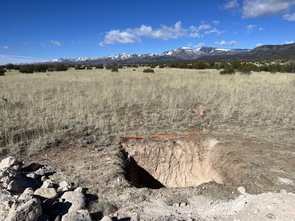
Pit dug for collection of geologic data and observations, such as geochronology samples to determine the age of faulted surfaces and documentation and dating of faulted recent sediments of the Puya Fault in northern New Mexico, 4/25/2023.
Jessica Thompson Jobe
Jessica Thompson Jobe is a research scientist in the Earthquake Hazards Program.
Science and Products
Filter Total Items: 24
Luminescence Data for: The Parguera fault: Possible Quaternary reactivation of a bedrock fault in southwest Puerto Rico Luminescence Data for: The Parguera fault: Possible Quaternary reactivation of a bedrock fault in southwest Puerto Rico
The following report summarizes the dating results from sedimentary deposits discovered during paleoseismic investigations of Puerto Rico. Within this report, we detail the methodology used by the USGS Luminescence Geochronology Laboratory to obtain ages including sample preparation methods, luminescence measurement, equivalent dose determination, and dating-related calculations. We...
Synthetic geologic deformation model distributions for use in 2025 USGS Puerto Rico-U.S. Virgin Islands National Seismic Hazard Model update Synthetic geologic deformation model distributions for use in 2025 USGS Puerto Rico-U.S. Virgin Islands National Seismic Hazard Model update
This Data Release provides synthetic probability density functions used in the geologic deformation model as part of the 2025 National Seismic Hazard Model update for Puerto Rico-U.S. Virgin Islands. We include files implemented in the earthquake rupture forecast using the inversion framework. Modeling philosophy and methodologies are described in the interpretative companion manuscript...
Western U.S. Date of Last Event (DOLE) for use in time-dependent probabilistic seismic hazard analyses Western U.S. Date of Last Event (DOLE) for use in time-dependent probabilistic seismic hazard analyses
This Data Release contains two compilations provide information on the date of the last known earthquake in the U.S. where available (conterminous U.S. and Alaska). There are two spatial datasets with different feature geometries — line features (“HistDOLE_v1”) and point features (“PaleoDOLE_v1”). The line features describe surface ruptures constrained by historical or near-historical...
Remote Surface Rupture Observations for the M7.7 2025 Mandalay, Burma (Myanmar) Earthquake Remote Surface Rupture Observations for the M7.7 2025 Mandalay, Burma (Myanmar) Earthquake
This data release contains datasets that depict fault rupture and surface displacement from the M7.7 Mandalay, Myanmar, earthquake on March 28, 2025. The earthquake caused ~475 km of right-lateral surface rupture on the Sagaing fault in Myanmar. These data were based on rapid analysis of available satellite data after the earthquake and updated as more information became available. They...
Supporting data for Late Pleistocene kinematics of the Great Southern Puerto Rico fault zone, Puerto Rico Supporting data for Late Pleistocene kinematics of the Great Southern Puerto Rico fault zone, Puerto Rico
This Data Release contains machine-readable files accompanying the study “Late Pleistocene kinematics of the Great Southern Puerto Rico fault zone, Puerto Rico” by Lynch et al. in Seismological Research Letters. The data release includes neotectonic mapping of fault-related features along the Great Southern Puerto Rico fault zone (GSPRFZ), and data documenting a focused site along the...
Datasets documenting Surface Rupture from an Aftershock: Remote Observations from the January 2024 Wushi (Aykol) Earthquakes, China Datasets documenting Surface Rupture from an Aftershock: Remote Observations from the January 2024 Wushi (Aykol) Earthquakes, China
This data release provides shapefiles of surface rupture mapping, interferometric synthetic aperture radar (InSAR) data, finite fault modeling inputs, parameters, and outputs, and optical image cross-correlation displacement data derived from high-resolution satellite imagery to accompany the manuscript “Thompson Jobe and others, Surface Rupture From an Aftershock: Remote Observations...
Datasets documenting Timescales of surface faulting preservation in low-strain intraplate regions from landscape evolution modeling and the geomorphic and historical record Datasets documenting Timescales of surface faulting preservation in low-strain intraplate regions from landscape evolution modeling and the geomorphic and historical record
This data release provides input data and landscape evolution modeling results to accompany the manuscript “Timescales of surface faulting preservation in low-strain intraplate regions from landscape evolution modeling and the geomorphic and historical record" (Thompson Jobe and Reitman, 2025). The data release includes two tabular datasets, a text file, and movies of the landscape...
Data Release for Luminescence: Neotectonic Mapping of Puerto Rico Data Release for Luminescence: Neotectonic Mapping of Puerto Rico
This report details the luminescence ages and characteristics of four (4) samples that were collected by Jessica Jobe and Rich Briggs of the USGS. These samples are from Holocene and Pleistocene sediments offset by a fault that is exposed in a road cut. The roadcut is in Puerto Rico at 18.003828 and -67.140249 with an elevation of 13.5 m. The sample depths from the modern surface varied...
Sediment core data from Henrys Lake, Idaho Sediment core data from Henrys Lake, Idaho
This data release includes measurements of properties from sedimentary cores collected from Henrys Lake in Idaho. We present a CSV with basic information about the cores (e.g., length, collection location, water depth), and three CSVs with the fallout radionuclide (FRN), particle size analysis (PSA), and radiocarbon (RC) data. It also has three child items with x-ray computed tomography...
Earthquake geology inputs for the National Seismic Hazard Model (NSHM) 2023 (central and eastern United States), version 1.0 Earthquake geology inputs for the National Seismic Hazard Model (NSHM) 2023 (central and eastern United States), version 1.0
This Data Release contains three related databases for the Central and Eastern United States: 1) A fault sections database ("NSHM2023_FaultSections_CEUS_v1"), which depicts the geometry of faults capable of hosting independent earthquakes, 2) A fault zone polygon database ("NSHM2023_FaultPolygons_CEUS_v1"), which depicts the geometry of distributed fault zones capable of hosting repeated...
Datasets documenting limited evidence of Late Pleistocene tectonic surface deformation in the Eastern Tennessee Seismic Zone, Tennessee, USA Datasets documenting limited evidence of Late Pleistocene tectonic surface deformation in the Eastern Tennessee Seismic Zone, Tennessee, USA
These datasets provide lineament mapping, catchment-averaged metrics of hypsometry and channel steepness, field observations, and a structure from motion model and orthomosiac photograph of sites in the Eastern Tennessee seismic zone in eastern Tennessee, USA. The lineament mapping contains linework of possible neotectonic features mapped from 1-m lidar data. Catchment-averaged metric of
Datasets documenting lineament mapping and neotectonic observations in northern New Mexico Datasets documenting lineament mapping and neotectonic observations in northern New Mexico
These datasets provide remotely mapped lineaments and neotectonic observations in northern New Mexico, based on 1-m lidar and satellite imagery data. Some lineaments are interpreted to be Quaternary-active faults, whereas others are interpreted to be older bedrock faults with no evidence for Quaternary movement. Simplified fault traces for interpreted Quaternary-active faults are...
Puya Fault sampling pit
Pit dug for collection of geologic data and observations, such as geochronology samples to determine the age of faulted surfaces and documentation and dating of faulted recent sediments of the Puya Fault in northern New Mexico, 4/25/2023.
Filter Total Items: 27
2025 USGS National Seismic Hazard Model for Puerto Rico and the U.S. Virgin Islands: Overview of model and hazard results 2025 USGS National Seismic Hazard Model for Puerto Rico and the U.S. Virgin Islands: Overview of model and hazard results
The U.S. Geological Survey recently updated the National Seismic Hazard Model (NSHM) for Puerto Rico and the U.S. Virgin Islands (PRVI). The first version of the PRVI NSHM was released in 2003, and therefore this 2025 update includes over 20 years of new geologic, geophysical, and engineering data, methods, and models. Updates follow similar efforts performed in the recent 2023 50-state...
Authors
Allison M. Shumway, Kevin Ross Milner, Peter M. Powers, Morgan P. Moschetti, Jason M. Altekruse, Julie A. Herrick, Andrea L. Llenos, Kyle B. Withers, Edward H. Field, Brad T. Aagaard, Richard W. Briggs, Alexandra Elise Hatem, Kirstie Lafon Haynie, Andrew J. Michael, Jessica A. Thompson Jobe, Kishor S. Jaiswal, Brandon S. Clayton, Nico Luco, Mark D. Petersen, Sanaz Rezaeian, Thomas L. Pratt, Yuehua Zeng
Surface rupture and slip distribution of the 2025 Mw7.7 Mandalay earthquake and updated length scaling of supershear earthquakes Surface rupture and slip distribution of the 2025 Mw7.7 Mandalay earthquake and updated length scaling of supershear earthquakes
The 2025 Mw 7.7 Mandalay, Burma (Myanmar), earthquake ruptured 475 km of the central Sagaing fault and is the longest continental strike-slip rupture on record. The observed rupture length is 1.6–4.7 times the value expected (100–300 km) from existing length-magnitude scaling relations for strike-slip earthquakes. The earthquake resulted from shallow dextral faulting and ruptured...
Authors
Nadine G. Reitman, Yuanshi Wang, Yu-Ting Kuo, Catherine Elise Hanagan, Alexandra Elise Hatem, Christopher B. DuRoss, Chun-Chi Chen, Dara Elyse Goldberg, Harriet Zoe Yin, Richard W. Briggs, Jessica A. Thompson Jobe, Sylvia R. Nicovich, Emerson Madelyn Lynch, Joseph Hoss Powell, William D. Barnhart, Robert G. Schmitt
Making many out of one: Synthetic geologic deformation model distributions for use in USGS NSHM25‐PRVI Puerto Rico-U.S. Virgin Island update Making many out of one: Synthetic geologic deformation model distributions for use in USGS NSHM25‐PRVI Puerto Rico-U.S. Virgin Island update
A key use‐case of geologic slip rates is within deformation models used in probabilistic seismic hazard analyses. Field‐derived geologic slip rates have formed the cornerstone of deformation models in such applications for decades. Recent advancements in seismic hazard analyses have expanded the use of faults for which geologic slip rates are not well constrained using categorical slip...
Authors
Alexandra Elise Hatem, Kevin Ross Milner, Richard W. Briggs, Jessica A. Thompson Jobe
The U.S. Geological Survey 2025 Puerto Rico and U.S. Virgin Islands time-independent earthquake rupture forecast The U.S. Geological Survey 2025 Puerto Rico and U.S. Virgin Islands time-independent earthquake rupture forecast
We present the 2025 U.S. Geological Survey Puerto Rico and U.S. Virgin Islands (PRVI) time‐independent earthquake rupture forecast (ERF), developed for the 2025 update to the National Seismic Hazard Model (NSHM) for PRVI. The updated ERF improves upon a prior model from 2003, including an expanded fault inventory with slip‐rate estimates, updated seismicity catalogs, and refined...
Authors
Kevin Ross Milner, Alexandra Elise Hatem, Richard W. Briggs, Jessica A. Thompson Jobe, Andrea L. Llenos, Andrew J. Michael, Allison M. Shumway, Edward H. Field, Kirstie Lafon Haynie
Late Pleistocene kinematics of the Great Southern Puerto Rico Fault Zone, Puerto Rico Late Pleistocene kinematics of the Great Southern Puerto Rico Fault Zone, Puerto Rico
Several onshore faults in southern Puerto Rico have recently been recognized as Quaternary active. However, the kinematics of these faults, particularly any lateral component, remain largely unconstrained. It is difficult to characterize low strain‐rate faults, partially due to extensive erosional and anthropogenic landscape modification, steep relief, and frequent landsliding, limiting...
Authors
Emerson Madelyn Lynch, Jessica A. Thompson Jobe, Richard W. Briggs, M. Morow Tan, Victor Ortega Díaz, K. Stephen Hughes
A scientific vision and roadmap for earthquake rupture forecast developments, a USGS perspective A scientific vision and roadmap for earthquake rupture forecast developments, a USGS perspective
We articulate a scientific vision and roadmap for the development of improved Earthquake Rupture Forecast models, which are one of the two main modeling components used in modern seismic hazard and risk analysis. One primary future objective is to provide fully time-dependent models that include both elastic rebound and spatiotemporal clustering nationwide, which is particularly...
Authors
Edward H. Field, Alexandra Elise Hatem, Bruce E. Shaw, Morgan T. Page, P. Martin Mai, Kevin Ross Milner, Andrea L. Llenos, Andrew J. Michael, Frederick Pollitz, Jessica A. Thompson Jobe, Thomas E. Parsons, Olaf Zielke, David R. Shelly, Alice-Agnes Gabriel, Devin McPhillips, Richard W. Briggs, Elizabeth S. Cochran, Nico Luco, Mark D. Petersen, Peter M. Powers, Justin L. Rubinstein, Allison M. Shumway, Nicholas van der Elst, Yuehua Zeng, Christopher B. DuRoss, Jason M. Altekruse
Timescales of surface faulting preservation in low-strain intraplate regions from landscape evolution modeling and the geomorphic and historical record Timescales of surface faulting preservation in low-strain intraplate regions from landscape evolution modeling and the geomorphic and historical record
Large surface-rupturing intraplate earthquakes in stable continental regions (SCRs) are uncommon globally and have recurrence intervals of thousands to hundreds of thousands of years based on the paleoseismic and geomorphic record, challenging accurate active fault identification in these regions. To constrain the timescales of preservation for scarps created by surface ruptures from dip...
Authors
Jessica A. Thompson Jobe, Nadine G. Reitman
Shallow lake, strong shake: Record of seismically triggered lacustrine sedimentation from the 1959 M7.3 Hebgen Lake earthquake within Henrys Lake, Idaho Shallow lake, strong shake: Record of seismically triggered lacustrine sedimentation from the 1959 M7.3 Hebgen Lake earthquake within Henrys Lake, Idaho
We investigate a shallow lake basin for evidence of a large historic intraplate earthquake in western North America. Henrys Lake, Idaho is an atypical candidate for a lacustrine paleoseismic study given its shallow depth (~7 m) and low relief (≤2° slopes). Here, we test the earthquake-recording capacity of this basin type by showing sedimentological evidence of the 1959 M7.3 Hebgen Lake...
Authors
Sylvia R. Nicovich, Christopher B. DuRoss, Jessica A. Thompson Jobe, Jessica R. Rodysill, Richard W. Briggs, Alexandra Elise Hatem, Madeleine Mai-Lynh Tan, Yann Gavillot, Noah Silas Lindberg, Laura E. Strickland, Jason Scott Padgett
Geologic input databases for the 2025 Puerto Rico – U.S. Virgin Islands National Seismic Hazard Model update: Crustal faults component Geologic input databases for the 2025 Puerto Rico – U.S. Virgin Islands National Seismic Hazard Model update: Crustal faults component
The last National Seismic Hazard Model (NSHM) for Puerto Rico and the U.S. Virgin Islands (PRVI) was published in 2003. In advance of the 2025 PRVI NSHM update, we created three geologic input databases to summarize new onshore and offshore fault source information in the northern Caribbean region between 62°–70° W and 16°–21° N. These databases, of fault sections, fault‐zone polygons...
Authors
Jessica A. Thompson Jobe, Richard W. Briggs, Uri S. ten Brink, Thomas L. Pratt, K. Stephen Hughes, Alexandra Elise Hatem, Christopher B. DuRoss, Nadine G. Reitman, Julie A. Herrick, Sylvia R. Nicovich, Camille Collett, Katherine M. Scharer, Stephen B. DeLong
Preliminary observations of the April 5th, 2024, Mw4.8 New Jersey earthquake Preliminary observations of the April 5th, 2024, Mw4.8 New Jersey earthquake
On 5 April 2024, 10:23 a.m. local time, a moment magnitude 4.8 earthquake struck Tewksbury Township, New Jersey, about 65 km west of New York City. Millions of people from Virginia to Maine and beyond felt the ground shaking, resulting in the largest number (>180,000) of U.S. Geological Survey (USGS) “Did You Feel It?” reports of any earthquake. A team deployed by the Geotechnical...
Authors
Oliver S. Boyd, William D. Barnhart, James Bourke, Martin C. Chapman, Paul S. Earle, Guo-chin Dino Huang, Jessica A. Thompson Jobe, Won-Young Kim, Frederick Link, Mairi Maclean Litherland, Andrew Lloyd, Maureen Long, Sara K. McBride, Andrew J. Michael, Walter D. Mooney, Gregory Moutain, Sissy Nikolaou, Alexandros Savvaidas, Felix Waldhauser, Cecily J. Wolfe, Clara Yoon
Neotectonic mapping of Puerto Rico Neotectonic mapping of Puerto Rico
Puerto Rico is part of the Puerto Rico-Virgin Islands microplate, along the Caribbean–North American plate boundary between the Puerto Rico trench subduction zone and the Muertos Trough incipient subduction zone. Despite recent seismicity and geodetically constrained deformation of ~3 mm/yr of left-lateral shear across the island, Quaternary fault locations remain largely uncertain...
Authors
Jessica A. Thompson Jobe, Richard W. Briggs, K. Stephen Hughes, J. Joyce, Ryan D. Gold, Shannon A. Mahan, Harrison J. Gray, Laura E. Strickland
Limited evidence of late Quaternary tectonic surface deformation in the eastern Tennessee seismic zone, USA Limited evidence of late Quaternary tectonic surface deformation in the eastern Tennessee seismic zone, USA
The ~300-km-long eastern Tennessee seismic zone (ETSZ), USA, is the second-most seismically active region east of the Rocky Mountains. Seismicity generally occurs below the Paleozoic fold-and-thrust belt within the Mesoproterozoic basement, at depths of 5–26 km, and earthquake magnitudes during the instrumental record have been moment magnitude ( Mw)≤4.8. Evidence of surface deformation...
Authors
Jessica A. Thompson Jobe, Richard W. Briggs, Ryan D. Gold, Laurel Bauer, Camille Collett
Science and Products
Filter Total Items: 24
Luminescence Data for: The Parguera fault: Possible Quaternary reactivation of a bedrock fault in southwest Puerto Rico Luminescence Data for: The Parguera fault: Possible Quaternary reactivation of a bedrock fault in southwest Puerto Rico
The following report summarizes the dating results from sedimentary deposits discovered during paleoseismic investigations of Puerto Rico. Within this report, we detail the methodology used by the USGS Luminescence Geochronology Laboratory to obtain ages including sample preparation methods, luminescence measurement, equivalent dose determination, and dating-related calculations. We...
Synthetic geologic deformation model distributions for use in 2025 USGS Puerto Rico-U.S. Virgin Islands National Seismic Hazard Model update Synthetic geologic deformation model distributions for use in 2025 USGS Puerto Rico-U.S. Virgin Islands National Seismic Hazard Model update
This Data Release provides synthetic probability density functions used in the geologic deformation model as part of the 2025 National Seismic Hazard Model update for Puerto Rico-U.S. Virgin Islands. We include files implemented in the earthquake rupture forecast using the inversion framework. Modeling philosophy and methodologies are described in the interpretative companion manuscript...
Western U.S. Date of Last Event (DOLE) for use in time-dependent probabilistic seismic hazard analyses Western U.S. Date of Last Event (DOLE) for use in time-dependent probabilistic seismic hazard analyses
This Data Release contains two compilations provide information on the date of the last known earthquake in the U.S. where available (conterminous U.S. and Alaska). There are two spatial datasets with different feature geometries — line features (“HistDOLE_v1”) and point features (“PaleoDOLE_v1”). The line features describe surface ruptures constrained by historical or near-historical...
Remote Surface Rupture Observations for the M7.7 2025 Mandalay, Burma (Myanmar) Earthquake Remote Surface Rupture Observations for the M7.7 2025 Mandalay, Burma (Myanmar) Earthquake
This data release contains datasets that depict fault rupture and surface displacement from the M7.7 Mandalay, Myanmar, earthquake on March 28, 2025. The earthquake caused ~475 km of right-lateral surface rupture on the Sagaing fault in Myanmar. These data were based on rapid analysis of available satellite data after the earthquake and updated as more information became available. They...
Supporting data for Late Pleistocene kinematics of the Great Southern Puerto Rico fault zone, Puerto Rico Supporting data for Late Pleistocene kinematics of the Great Southern Puerto Rico fault zone, Puerto Rico
This Data Release contains machine-readable files accompanying the study “Late Pleistocene kinematics of the Great Southern Puerto Rico fault zone, Puerto Rico” by Lynch et al. in Seismological Research Letters. The data release includes neotectonic mapping of fault-related features along the Great Southern Puerto Rico fault zone (GSPRFZ), and data documenting a focused site along the...
Datasets documenting Surface Rupture from an Aftershock: Remote Observations from the January 2024 Wushi (Aykol) Earthquakes, China Datasets documenting Surface Rupture from an Aftershock: Remote Observations from the January 2024 Wushi (Aykol) Earthquakes, China
This data release provides shapefiles of surface rupture mapping, interferometric synthetic aperture radar (InSAR) data, finite fault modeling inputs, parameters, and outputs, and optical image cross-correlation displacement data derived from high-resolution satellite imagery to accompany the manuscript “Thompson Jobe and others, Surface Rupture From an Aftershock: Remote Observations...
Datasets documenting Timescales of surface faulting preservation in low-strain intraplate regions from landscape evolution modeling and the geomorphic and historical record Datasets documenting Timescales of surface faulting preservation in low-strain intraplate regions from landscape evolution modeling and the geomorphic and historical record
This data release provides input data and landscape evolution modeling results to accompany the manuscript “Timescales of surface faulting preservation in low-strain intraplate regions from landscape evolution modeling and the geomorphic and historical record" (Thompson Jobe and Reitman, 2025). The data release includes two tabular datasets, a text file, and movies of the landscape...
Data Release for Luminescence: Neotectonic Mapping of Puerto Rico Data Release for Luminescence: Neotectonic Mapping of Puerto Rico
This report details the luminescence ages and characteristics of four (4) samples that were collected by Jessica Jobe and Rich Briggs of the USGS. These samples are from Holocene and Pleistocene sediments offset by a fault that is exposed in a road cut. The roadcut is in Puerto Rico at 18.003828 and -67.140249 with an elevation of 13.5 m. The sample depths from the modern surface varied...
Sediment core data from Henrys Lake, Idaho Sediment core data from Henrys Lake, Idaho
This data release includes measurements of properties from sedimentary cores collected from Henrys Lake in Idaho. We present a CSV with basic information about the cores (e.g., length, collection location, water depth), and three CSVs with the fallout radionuclide (FRN), particle size analysis (PSA), and radiocarbon (RC) data. It also has three child items with x-ray computed tomography...
Earthquake geology inputs for the National Seismic Hazard Model (NSHM) 2023 (central and eastern United States), version 1.0 Earthquake geology inputs for the National Seismic Hazard Model (NSHM) 2023 (central and eastern United States), version 1.0
This Data Release contains three related databases for the Central and Eastern United States: 1) A fault sections database ("NSHM2023_FaultSections_CEUS_v1"), which depicts the geometry of faults capable of hosting independent earthquakes, 2) A fault zone polygon database ("NSHM2023_FaultPolygons_CEUS_v1"), which depicts the geometry of distributed fault zones capable of hosting repeated...
Datasets documenting limited evidence of Late Pleistocene tectonic surface deformation in the Eastern Tennessee Seismic Zone, Tennessee, USA Datasets documenting limited evidence of Late Pleistocene tectonic surface deformation in the Eastern Tennessee Seismic Zone, Tennessee, USA
These datasets provide lineament mapping, catchment-averaged metrics of hypsometry and channel steepness, field observations, and a structure from motion model and orthomosiac photograph of sites in the Eastern Tennessee seismic zone in eastern Tennessee, USA. The lineament mapping contains linework of possible neotectonic features mapped from 1-m lidar data. Catchment-averaged metric of
Datasets documenting lineament mapping and neotectonic observations in northern New Mexico Datasets documenting lineament mapping and neotectonic observations in northern New Mexico
These datasets provide remotely mapped lineaments and neotectonic observations in northern New Mexico, based on 1-m lidar and satellite imagery data. Some lineaments are interpreted to be Quaternary-active faults, whereas others are interpreted to be older bedrock faults with no evidence for Quaternary movement. Simplified fault traces for interpreted Quaternary-active faults are...
Puya Fault sampling pit
Pit dug for collection of geologic data and observations, such as geochronology samples to determine the age of faulted surfaces and documentation and dating of faulted recent sediments of the Puya Fault in northern New Mexico, 4/25/2023.
Pit dug for collection of geologic data and observations, such as geochronology samples to determine the age of faulted surfaces and documentation and dating of faulted recent sediments of the Puya Fault in northern New Mexico, 4/25/2023.
Filter Total Items: 27
2025 USGS National Seismic Hazard Model for Puerto Rico and the U.S. Virgin Islands: Overview of model and hazard results 2025 USGS National Seismic Hazard Model for Puerto Rico and the U.S. Virgin Islands: Overview of model and hazard results
The U.S. Geological Survey recently updated the National Seismic Hazard Model (NSHM) for Puerto Rico and the U.S. Virgin Islands (PRVI). The first version of the PRVI NSHM was released in 2003, and therefore this 2025 update includes over 20 years of new geologic, geophysical, and engineering data, methods, and models. Updates follow similar efforts performed in the recent 2023 50-state...
Authors
Allison M. Shumway, Kevin Ross Milner, Peter M. Powers, Morgan P. Moschetti, Jason M. Altekruse, Julie A. Herrick, Andrea L. Llenos, Kyle B. Withers, Edward H. Field, Brad T. Aagaard, Richard W. Briggs, Alexandra Elise Hatem, Kirstie Lafon Haynie, Andrew J. Michael, Jessica A. Thompson Jobe, Kishor S. Jaiswal, Brandon S. Clayton, Nico Luco, Mark D. Petersen, Sanaz Rezaeian, Thomas L. Pratt, Yuehua Zeng
Surface rupture and slip distribution of the 2025 Mw7.7 Mandalay earthquake and updated length scaling of supershear earthquakes Surface rupture and slip distribution of the 2025 Mw7.7 Mandalay earthquake and updated length scaling of supershear earthquakes
The 2025 Mw 7.7 Mandalay, Burma (Myanmar), earthquake ruptured 475 km of the central Sagaing fault and is the longest continental strike-slip rupture on record. The observed rupture length is 1.6–4.7 times the value expected (100–300 km) from existing length-magnitude scaling relations for strike-slip earthquakes. The earthquake resulted from shallow dextral faulting and ruptured...
Authors
Nadine G. Reitman, Yuanshi Wang, Yu-Ting Kuo, Catherine Elise Hanagan, Alexandra Elise Hatem, Christopher B. DuRoss, Chun-Chi Chen, Dara Elyse Goldberg, Harriet Zoe Yin, Richard W. Briggs, Jessica A. Thompson Jobe, Sylvia R. Nicovich, Emerson Madelyn Lynch, Joseph Hoss Powell, William D. Barnhart, Robert G. Schmitt
Making many out of one: Synthetic geologic deformation model distributions for use in USGS NSHM25‐PRVI Puerto Rico-U.S. Virgin Island update Making many out of one: Synthetic geologic deformation model distributions for use in USGS NSHM25‐PRVI Puerto Rico-U.S. Virgin Island update
A key use‐case of geologic slip rates is within deformation models used in probabilistic seismic hazard analyses. Field‐derived geologic slip rates have formed the cornerstone of deformation models in such applications for decades. Recent advancements in seismic hazard analyses have expanded the use of faults for which geologic slip rates are not well constrained using categorical slip...
Authors
Alexandra Elise Hatem, Kevin Ross Milner, Richard W. Briggs, Jessica A. Thompson Jobe
The U.S. Geological Survey 2025 Puerto Rico and U.S. Virgin Islands time-independent earthquake rupture forecast The U.S. Geological Survey 2025 Puerto Rico and U.S. Virgin Islands time-independent earthquake rupture forecast
We present the 2025 U.S. Geological Survey Puerto Rico and U.S. Virgin Islands (PRVI) time‐independent earthquake rupture forecast (ERF), developed for the 2025 update to the National Seismic Hazard Model (NSHM) for PRVI. The updated ERF improves upon a prior model from 2003, including an expanded fault inventory with slip‐rate estimates, updated seismicity catalogs, and refined...
Authors
Kevin Ross Milner, Alexandra Elise Hatem, Richard W. Briggs, Jessica A. Thompson Jobe, Andrea L. Llenos, Andrew J. Michael, Allison M. Shumway, Edward H. Field, Kirstie Lafon Haynie
Late Pleistocene kinematics of the Great Southern Puerto Rico Fault Zone, Puerto Rico Late Pleistocene kinematics of the Great Southern Puerto Rico Fault Zone, Puerto Rico
Several onshore faults in southern Puerto Rico have recently been recognized as Quaternary active. However, the kinematics of these faults, particularly any lateral component, remain largely unconstrained. It is difficult to characterize low strain‐rate faults, partially due to extensive erosional and anthropogenic landscape modification, steep relief, and frequent landsliding, limiting...
Authors
Emerson Madelyn Lynch, Jessica A. Thompson Jobe, Richard W. Briggs, M. Morow Tan, Victor Ortega Díaz, K. Stephen Hughes
A scientific vision and roadmap for earthquake rupture forecast developments, a USGS perspective A scientific vision and roadmap for earthquake rupture forecast developments, a USGS perspective
We articulate a scientific vision and roadmap for the development of improved Earthquake Rupture Forecast models, which are one of the two main modeling components used in modern seismic hazard and risk analysis. One primary future objective is to provide fully time-dependent models that include both elastic rebound and spatiotemporal clustering nationwide, which is particularly...
Authors
Edward H. Field, Alexandra Elise Hatem, Bruce E. Shaw, Morgan T. Page, P. Martin Mai, Kevin Ross Milner, Andrea L. Llenos, Andrew J. Michael, Frederick Pollitz, Jessica A. Thompson Jobe, Thomas E. Parsons, Olaf Zielke, David R. Shelly, Alice-Agnes Gabriel, Devin McPhillips, Richard W. Briggs, Elizabeth S. Cochran, Nico Luco, Mark D. Petersen, Peter M. Powers, Justin L. Rubinstein, Allison M. Shumway, Nicholas van der Elst, Yuehua Zeng, Christopher B. DuRoss, Jason M. Altekruse
Timescales of surface faulting preservation in low-strain intraplate regions from landscape evolution modeling and the geomorphic and historical record Timescales of surface faulting preservation in low-strain intraplate regions from landscape evolution modeling and the geomorphic and historical record
Large surface-rupturing intraplate earthquakes in stable continental regions (SCRs) are uncommon globally and have recurrence intervals of thousands to hundreds of thousands of years based on the paleoseismic and geomorphic record, challenging accurate active fault identification in these regions. To constrain the timescales of preservation for scarps created by surface ruptures from dip...
Authors
Jessica A. Thompson Jobe, Nadine G. Reitman
Shallow lake, strong shake: Record of seismically triggered lacustrine sedimentation from the 1959 M7.3 Hebgen Lake earthquake within Henrys Lake, Idaho Shallow lake, strong shake: Record of seismically triggered lacustrine sedimentation from the 1959 M7.3 Hebgen Lake earthquake within Henrys Lake, Idaho
We investigate a shallow lake basin for evidence of a large historic intraplate earthquake in western North America. Henrys Lake, Idaho is an atypical candidate for a lacustrine paleoseismic study given its shallow depth (~7 m) and low relief (≤2° slopes). Here, we test the earthquake-recording capacity of this basin type by showing sedimentological evidence of the 1959 M7.3 Hebgen Lake...
Authors
Sylvia R. Nicovich, Christopher B. DuRoss, Jessica A. Thompson Jobe, Jessica R. Rodysill, Richard W. Briggs, Alexandra Elise Hatem, Madeleine Mai-Lynh Tan, Yann Gavillot, Noah Silas Lindberg, Laura E. Strickland, Jason Scott Padgett
Geologic input databases for the 2025 Puerto Rico – U.S. Virgin Islands National Seismic Hazard Model update: Crustal faults component Geologic input databases for the 2025 Puerto Rico – U.S. Virgin Islands National Seismic Hazard Model update: Crustal faults component
The last National Seismic Hazard Model (NSHM) for Puerto Rico and the U.S. Virgin Islands (PRVI) was published in 2003. In advance of the 2025 PRVI NSHM update, we created three geologic input databases to summarize new onshore and offshore fault source information in the northern Caribbean region between 62°–70° W and 16°–21° N. These databases, of fault sections, fault‐zone polygons...
Authors
Jessica A. Thompson Jobe, Richard W. Briggs, Uri S. ten Brink, Thomas L. Pratt, K. Stephen Hughes, Alexandra Elise Hatem, Christopher B. DuRoss, Nadine G. Reitman, Julie A. Herrick, Sylvia R. Nicovich, Camille Collett, Katherine M. Scharer, Stephen B. DeLong
Preliminary observations of the April 5th, 2024, Mw4.8 New Jersey earthquake Preliminary observations of the April 5th, 2024, Mw4.8 New Jersey earthquake
On 5 April 2024, 10:23 a.m. local time, a moment magnitude 4.8 earthquake struck Tewksbury Township, New Jersey, about 65 km west of New York City. Millions of people from Virginia to Maine and beyond felt the ground shaking, resulting in the largest number (>180,000) of U.S. Geological Survey (USGS) “Did You Feel It?” reports of any earthquake. A team deployed by the Geotechnical...
Authors
Oliver S. Boyd, William D. Barnhart, James Bourke, Martin C. Chapman, Paul S. Earle, Guo-chin Dino Huang, Jessica A. Thompson Jobe, Won-Young Kim, Frederick Link, Mairi Maclean Litherland, Andrew Lloyd, Maureen Long, Sara K. McBride, Andrew J. Michael, Walter D. Mooney, Gregory Moutain, Sissy Nikolaou, Alexandros Savvaidas, Felix Waldhauser, Cecily J. Wolfe, Clara Yoon
Neotectonic mapping of Puerto Rico Neotectonic mapping of Puerto Rico
Puerto Rico is part of the Puerto Rico-Virgin Islands microplate, along the Caribbean–North American plate boundary between the Puerto Rico trench subduction zone and the Muertos Trough incipient subduction zone. Despite recent seismicity and geodetically constrained deformation of ~3 mm/yr of left-lateral shear across the island, Quaternary fault locations remain largely uncertain...
Authors
Jessica A. Thompson Jobe, Richard W. Briggs, K. Stephen Hughes, J. Joyce, Ryan D. Gold, Shannon A. Mahan, Harrison J. Gray, Laura E. Strickland
Limited evidence of late Quaternary tectonic surface deformation in the eastern Tennessee seismic zone, USA Limited evidence of late Quaternary tectonic surface deformation in the eastern Tennessee seismic zone, USA
The ~300-km-long eastern Tennessee seismic zone (ETSZ), USA, is the second-most seismically active region east of the Rocky Mountains. Seismicity generally occurs below the Paleozoic fold-and-thrust belt within the Mesoproterozoic basement, at depths of 5–26 km, and earthquake magnitudes during the instrumental record have been moment magnitude ( Mw)≤4.8. Evidence of surface deformation...
Authors
Jessica A. Thompson Jobe, Richard W. Briggs, Ryan D. Gold, Laurel Bauer, Camille Collett