
River Silicon Stoichiometry FY26 Working Group
Flood Impacts FY26 Working Group
New Data for Hazards Models FY26 Working Group
Metal Subsidy Stress FY26 Working Group
Water Cycle Synchrony (CUAHSI) FY26 Working Group
Contaminant Food Webs FY26 Working Group
John Wesley Powell Center for Analysis and Synthesis
Offering the opportunity for emergent knowledge in Earth system science through collaborative analysis and synthesis.
Working Group Resources
Working Group Resources

Information for working group leaders, visitors to the Powell Center, travel information, data resources, and the Powell Center Acknowledgement.
Proposal Process
Proposal Process

Instructions and resources for submitting proposals and accepted working groups.
News
Powell Center Working Groups - Class of 2027
Powell Center Working Groups - Class of 2027
Powell Center Seminar: Beyond waves and shifting sand: considering ecosystem processes in forecasts of coastal landscape change
Powell Center Seminar: Beyond waves and shifting sand: considering ecosystem processes in forecasts of coastal landscape change
John Wesley Powell Center for Analysis and Synthesis Newsletter, Volume 9 - Vol. 9 | Issue 1
John Wesley Powell Center for Analysis and Synthesis Newsletter, Volume 9 - Vol. 9 | Issue 1
Publications
Hierarchical mixture models and high-resolution monitoring data can inform siting and operational strategies to mitigate bat fatalities at wind turbines Hierarchical mixture models and high-resolution monitoring data can inform siting and operational strategies to mitigate bat fatalities at wind turbines
Bats provide critical ecosystem services, but bat fatalities due to wind energy development may imperil some bat populations. Statistical models are used to estimate the total fatalities that occur based on carcasses observed during monitoring surveys. Current models often estimate fatalities aggregated across species, time, and/or turbines, but fall short of reliably informing siting...
Surface variable‐based machine learning for scalable arsenic prediction in undersampled areas Surface variable‐based machine learning for scalable arsenic prediction in undersampled areas
In the United States, private wells are not federally regulated, and many households do not test for Arsenic (As). Chronic exposure is linked with multiple health outcomes, and risk can change sharply over short distances and with well depth. Coarse maps or sparse sampling often miss exceedances. Most existing models operate at ∼1 km resolution and use groundwater chemistry or detailed...
Identifying headwater streams across the conterminous United States Identifying headwater streams across the conterminous United States
Headwater streams play critical roles in hydrologic and biogeochemical processes and functions, yet their spatial distribution and land cover context remain poorly understood at continental scales, and no dedicated geospatial dataset exists. Building from a high-resolution conterminous United States (CONUS) hydrography network dataset, we quantified the spatial extent, density, and...
Science
Synthesizing methane fluxes, isotopes, and microbiomes to better understand the dynamics and consequences of permafrost thaw in a sensitive and strategic Arctic
This interdisciplinary working group will bring together leading experts in microbial ecology, biogeochemistry, isotope science, remote sensing, and ecosystem modeling to synthesize how Arctic ecosystems are responding to changes in microbial and landscape processes.

Towards an integrated multi-scale understanding of dryland plant traits with application to land management
This proposed project brings together scientists, federal agencies, and land managers to improve the monitoring and management of dryland ecosystems in the western United States.
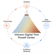
A digital twin to accelerate volcano science and unify geodetic and seismic observations
Emerging computational and data assimilation approaches and increasing data volumes imply an opportunity to greatly accelerate both fundamental volcano science and hazard assessment and forecasting.