
On December 20, 2020, an eruption began in Halema‘uma‘u at Kīlauea Volcano’s summit, ending a two-year eruptive pause. The water lake that appeared at the bottom of Halema‘uma‘u in late July 2019, which had grown to be over 50 meters (55 yards) deep and more than 10 acres in surface area, quickly vaporized and was replaced by a growing lava lake.
Katherine (Katie) M. Mulliken
Geologist and external engagement coordinator at the USGS Hawaiian Volcano Observatory (HVO).
Working closely with HVO scientists, seismic analysts, field engineers, network managers, and the Scientist-in-Charge, I help HVO to communicate about the work we do monitoring earthquakes, eruptions, and associated hazards in Hawaii. I manage the weekly "Volcano Watch" column, coordinate social and traditional media, and administer HVO website content. Every January, I lead "Volcano Awareness Month" during which HVO and partners provide in-person events around the Island of Hawaiʻi.
I have been involved in eruption response efforts since 2018, including on Kīlauea East Rift Zone, Southwest Rift Zone, several within Kaluapele (Kīlauea summit caldera), and Mauna Loa in 2022. Additionally, I have responded to numerous earthquakes, earthquake swarms, and intrusive events in Hawaii.
Prior to working for HVO, I worked for several years as an Alaska Volcano Observatory geologist at the Alaska Division of Geological & Geophysical Surveys. I also have training as an archaeologist and spent several years doing archaeological survey and excavation work in remote parts of the State of Alaska.
Science and Products
Filter Total Items: 37

What’s happening at Kīlauea Volcano?
On December 20, 2020, an eruption began in Halema‘uma‘u at Kīlauea Volcano’s summit, ending a two-year eruptive pause. The water lake that appeared at the bottom of Halema‘uma‘u in late July 2019, which had grown to be over 50 meters (55 yards) deep and more than 10 acres in surface area, quickly vaporized and was replaced by a growing lava lake.

USGS Volcano Observatories in 2020: Past 10 Years; The Future
USGS Volcano Observatories in 2020: Past 10 Years; The FutureTalk by Tina Neal–USGS Alaska Volcano Observatory geologist and former USGS Hawaiian Volcano Observatory Scientist-in-Charge. Talk originally presented at the American Geophysical Union Fall Meeting 2020.

May 29, 2020—Updated aerial map of Kīlauea summit
The May 29 overflight provided updated aerial photographs of Kīlauea summit, covering the caldera floor and showing the current size of the water lake in Halema‘uma‘u crater.
The May 29 overflight provided updated aerial photographs of Kīlauea summit, covering the caldera floor and showing the current size of the water lake in Halema‘uma‘u crater.

What will you do when Earth’s largest active volcano erupts?
What will you do when Earth’s largest active volcano erupts?In 2019, the Volcano Alert Level for Mauna Loa was elevated from “NORMAL” to “ADVISORY” due to increased seismicity and deformation at the volcano. This alert level does not mean an eruption is imminent, but it is a fact that Mauna Loa, which has erupted 33 times since 1843 (most recently in 1984), will erupt again. What will you do when it does?

What can lava tell us? Deciphering Kīlauea’s 2018 eruption
What can lava tell us? Deciphering Kīlauea’s 2018 eruptionThe 2018 eruption on Kīlauea’s lower East Rift Zone spewed around a billion cubic yards of lava into Puna. From the moment the eruption began, samples of lava were collected and rapidly analyzed by a team of USGS Hawaiian Volcano Observatory and University of Hawaiʻi at Hilo scientists.

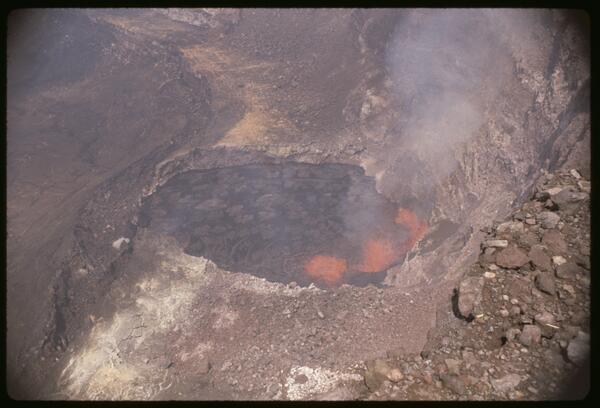
What’s happening at Kīlauea Volcano’s summit?
Kīlauea Volcano's summit has been in an eruptive pause since the 2018 events ended over a year ago. Nevertheless, it remains a dynamic place. Ongoing inflation and seismicity indicate that the summit magma chamber is gradually recharging.
Kīlauea Volcano's summit has been in an eruptive pause since the 2018 events ended over a year ago. Nevertheless, it remains a dynamic place. Ongoing inflation and seismicity indicate that the summit magma chamber is gradually recharging.

Sampling the water in Halema‘uma‘u - Kīlauea Volcano
Sampling the water in Halema‘uma‘u - Kīlauea VolcanoUSGS Hawaiian Volcano Observatory scientists Frank Younger and Patricia Nadeau talk about sampling the water at the bottom of Halemaʻumaʻu, a crater at the summit of Kīlauea Volcano. The water appeared in July 2019 and has steadily risen since then.

Water appears in Halemaʻumaʻu - Kīlauea Volcano
USGS Hawaiian Volcano Observatory scientists Matt Patrick and Jim Kauahikaua talk about the water that appeared at the bottom of Halemaʻumaʻu, a crater at the summit of Kīlauea Volcano, in July 2019 and continues to rise today. They address why it appeared, how it’s monitored, and its potential hazards.
USGS Hawaiian Volcano Observatory scientists Matt Patrick and Jim Kauahikaua talk about the water that appeared at the bottom of Halemaʻumaʻu, a crater at the summit of Kīlauea Volcano, in July 2019 and continues to rise today. They address why it appeared, how it’s monitored, and its potential hazards.
April 1982 Kaluapele Eruption
The April 30, 1982, Kaluapele eruption was a short-lived summit event that lasted about 19 hours. Lava erupted from a 3,200-foot-long fissure northeast of Halemaʻumaʻu crater, producing low fountains 15–30 feet high, with bursts up to 160 feet.
The April 30, 1982, Kaluapele eruption was a short-lived summit event that lasted about 19 hours. Lava erupted from a 3,200-foot-long fissure northeast of Halemaʻumaʻu crater, producing low fountains 15–30 feet high, with bursts up to 160 feet.
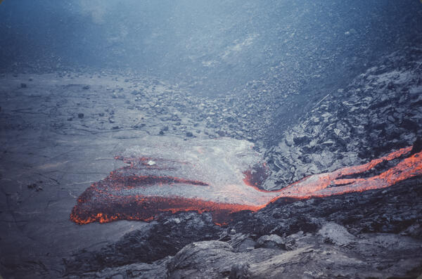
November 1979 Pauahi Eruption
The November 16, 1979, eruption near Pauahi Crater was a brief, one-day event on the upper East Rift Zone. It was preceded by two months of increased seismic activity, summit inflation, and lava erupting from fissures west of, within, and east of the crater.
The November 16, 1979, eruption near Pauahi Crater was a brief, one-day event on the upper East Rift Zone. It was preceded by two months of increased seismic activity, summit inflation, and lava erupting from fissures west of, within, and east of the crater.
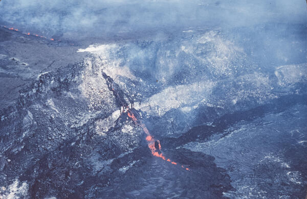
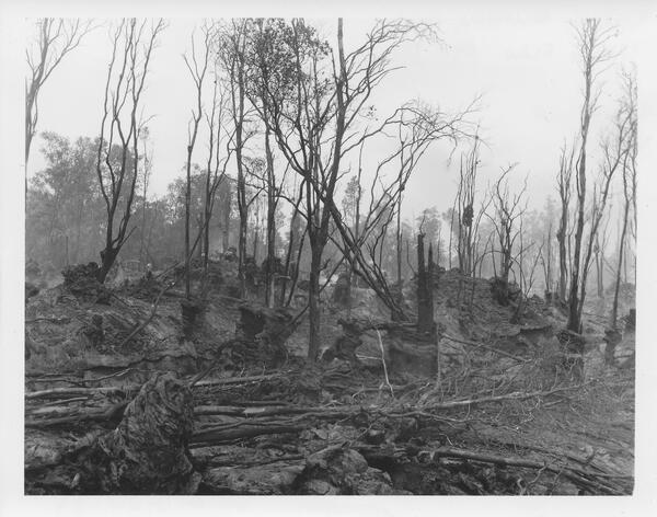
September 1977 Kalalu/Puu Kauka Eruption
The September 1977 eruption of Kīlauea began after nearly two years of dormancy, with activity breaking out on September 13 along a 3.5-mile-long fissure system between the prehistoric cones of Kalalua and Puʻu Kauka.
The September 1977 eruption of Kīlauea began after nearly two years of dormancy, with activity breaking out on September 13 along a 3.5-mile-long fissure system between the prehistoric cones of Kalalua and Puʻu Kauka.
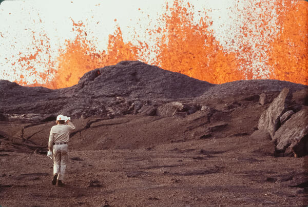
July 1974 Keanakākoʻi Eruption
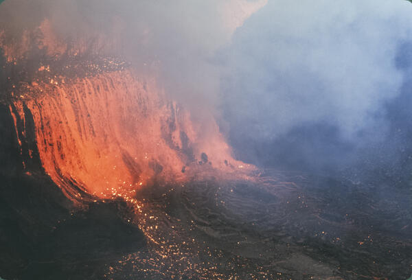
The July 19–22, 1974, Keanakākoʻi eruption was a dramatic summit event triggered by a sudden increase in seismicity and summit deflation. Lava fountains up to 180 feet high erupted from fissures north and south of Keanakākoʻi Crater and on the caldera floor, sending lava flows about 1.5 miles southward and across the caldera floor.
The July 19–22, 1974, Keanakākoʻi eruption was a dramatic summit event triggered by a sudden increase in seismicity and summit deflation. Lava fountains up to 180 feet high erupted from fissures north and south of Keanakākoʻi Crater and on the caldera floor, sending lava flows about 1.5 miles southward and across the caldera floor.
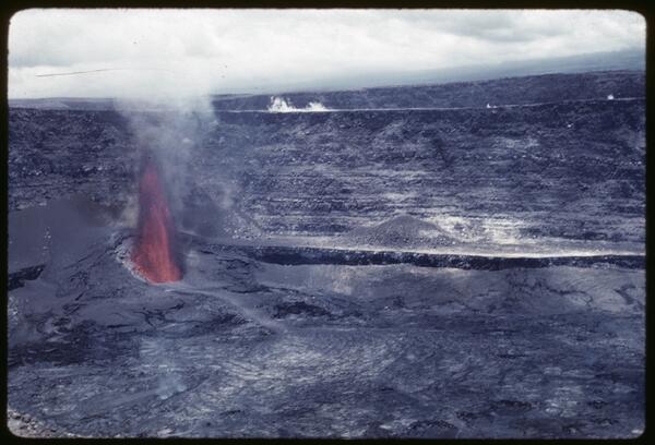
1969 Rift Eruption near Nāpau Crater
The February 1969 rift eruption near Nāpau Crater was a brief but dynamic precursor to the long-lived Maunaulu eruption that began in May of that year. This week-long event featured lava fountaining from multiple fissures along a 2.5-mile stretch of Kīlauea’s upper East Rift Zone.
The February 1969 rift eruption near Nāpau Crater was a brief but dynamic precursor to the long-lived Maunaulu eruption that began in May of that year. This week-long event featured lava fountaining from multiple fissures along a 2.5-mile stretch of Kīlauea’s upper East Rift Zone.
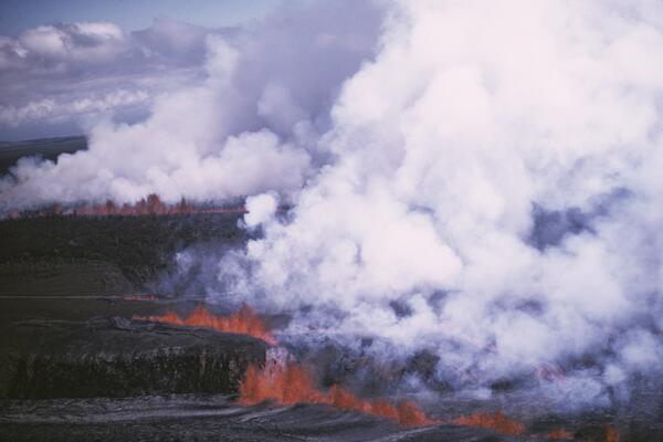
1961 Fissure Eruption near Nāpau Crater
The 1961 fissure eruption near Nāpau Crater was a short-lived but notable event on Kīlauea’s East Rift Zone, occurring in late September. Over two days, lava erupted from vents along a 13-mile stretch, producing 13 small flows and lava fountains that reached heights of up to 400 feet, with the largest flows occurring near Pāhoa.
The 1961 fissure eruption near Nāpau Crater was a short-lived but notable event on Kīlauea’s East Rift Zone, occurring in late September. Over two days, lava erupted from vents along a 13-mile stretch, producing 13 small flows and lava fountains that reached heights of up to 400 feet, with the largest flows occurring near Pāhoa.
July 1961 Summit Eruption
The July 1961 eruption at Halemaʻumaʻu was the third summit eruption of that year, continuing the pattern of vigorous volcanic activity at Kīlauea. This event featured sustained lava fountaining and further infilling of the crater, building upon the changes initiated by the February and March eruptions.
The July 1961 eruption at Halemaʻumaʻu was the third summit eruption of that year, continuing the pattern of vigorous volcanic activity at Kīlauea. This event featured sustained lava fountaining and further infilling of the crater, building upon the changes initiated by the February and March eruptions.
February 1961 Halemaʻumaʻu Summit Eruption
The February 1961 summit eruption of Kīlauea marked the beginning of a year of intense volcanic activity, characterized by three distinct summit eruptive phases.
The February 1961 summit eruption of Kīlauea marked the beginning of a year of intense volcanic activity, characterized by three distinct summit eruptive phases.
Science and Products
Filter Total Items: 37
What’s happening at Kīlauea Volcano?
On December 20, 2020, an eruption began in Halema‘uma‘u at Kīlauea Volcano’s summit, ending a two-year eruptive pause. The water lake that appeared at the bottom of Halema‘uma‘u in late July 2019, which had grown to be over 50 meters (55 yards) deep and more than 10 acres in surface area, quickly vaporized and was replaced by a growing lava lake.
On December 20, 2020, an eruption began in Halema‘uma‘u at Kīlauea Volcano’s summit, ending a two-year eruptive pause. The water lake that appeared at the bottom of Halema‘uma‘u in late July 2019, which had grown to be over 50 meters (55 yards) deep and more than 10 acres in surface area, quickly vaporized and was replaced by a growing lava lake.
USGS Volcano Observatories in 2020: Past 10 Years; The Future
USGS Volcano Observatories in 2020: Past 10 Years; The FutureTalk by Tina Neal–USGS Alaska Volcano Observatory geologist and former USGS Hawaiian Volcano Observatory Scientist-in-Charge. Talk originally presented at the American Geophysical Union Fall Meeting 2020.
May 29, 2020—Updated aerial map of Kīlauea summit
The May 29 overflight provided updated aerial photographs of Kīlauea summit, covering the caldera floor and showing the current size of the water lake in Halema‘uma‘u crater.
The May 29 overflight provided updated aerial photographs of Kīlauea summit, covering the caldera floor and showing the current size of the water lake in Halema‘uma‘u crater.
What will you do when Earth’s largest active volcano erupts?
What will you do when Earth’s largest active volcano erupts?In 2019, the Volcano Alert Level for Mauna Loa was elevated from “NORMAL” to “ADVISORY” due to increased seismicity and deformation at the volcano. This alert level does not mean an eruption is imminent, but it is a fact that Mauna Loa, which has erupted 33 times since 1843 (most recently in 1984), will erupt again. What will you do when it does?
What can lava tell us? Deciphering Kīlauea’s 2018 eruption
What can lava tell us? Deciphering Kīlauea’s 2018 eruptionThe 2018 eruption on Kīlauea’s lower East Rift Zone spewed around a billion cubic yards of lava into Puna. From the moment the eruption began, samples of lava were collected and rapidly analyzed by a team of USGS Hawaiian Volcano Observatory and University of Hawaiʻi at Hilo scientists.
What’s happening at Kīlauea Volcano’s summit?
Kīlauea Volcano's summit has been in an eruptive pause since the 2018 events ended over a year ago. Nevertheless, it remains a dynamic place. Ongoing inflation and seismicity indicate that the summit magma chamber is gradually recharging.
Kīlauea Volcano's summit has been in an eruptive pause since the 2018 events ended over a year ago. Nevertheless, it remains a dynamic place. Ongoing inflation and seismicity indicate that the summit magma chamber is gradually recharging.
Sampling the water in Halema‘uma‘u - Kīlauea Volcano
Sampling the water in Halema‘uma‘u - Kīlauea VolcanoUSGS Hawaiian Volcano Observatory scientists Frank Younger and Patricia Nadeau talk about sampling the water at the bottom of Halemaʻumaʻu, a crater at the summit of Kīlauea Volcano. The water appeared in July 2019 and has steadily risen since then.
Water appears in Halemaʻumaʻu - Kīlauea Volcano
USGS Hawaiian Volcano Observatory scientists Matt Patrick and Jim Kauahikaua talk about the water that appeared at the bottom of Halemaʻumaʻu, a crater at the summit of Kīlauea Volcano, in July 2019 and continues to rise today. They address why it appeared, how it’s monitored, and its potential hazards.
USGS Hawaiian Volcano Observatory scientists Matt Patrick and Jim Kauahikaua talk about the water that appeared at the bottom of Halemaʻumaʻu, a crater at the summit of Kīlauea Volcano, in July 2019 and continues to rise today. They address why it appeared, how it’s monitored, and its potential hazards.
April 1982 Kaluapele Eruption
The April 30, 1982, Kaluapele eruption was a short-lived summit event that lasted about 19 hours. Lava erupted from a 3,200-foot-long fissure northeast of Halemaʻumaʻu crater, producing low fountains 15–30 feet high, with bursts up to 160 feet.
The April 30, 1982, Kaluapele eruption was a short-lived summit event that lasted about 19 hours. Lava erupted from a 3,200-foot-long fissure northeast of Halemaʻumaʻu crater, producing low fountains 15–30 feet high, with bursts up to 160 feet.
November 1979 Pauahi Eruption
The November 16, 1979, eruption near Pauahi Crater was a brief, one-day event on the upper East Rift Zone. It was preceded by two months of increased seismic activity, summit inflation, and lava erupting from fissures west of, within, and east of the crater.
The November 16, 1979, eruption near Pauahi Crater was a brief, one-day event on the upper East Rift Zone. It was preceded by two months of increased seismic activity, summit inflation, and lava erupting from fissures west of, within, and east of the crater.
September 1977 Kalalu/Puu Kauka Eruption
The September 1977 eruption of Kīlauea began after nearly two years of dormancy, with activity breaking out on September 13 along a 3.5-mile-long fissure system between the prehistoric cones of Kalalua and Puʻu Kauka.
The September 1977 eruption of Kīlauea began after nearly two years of dormancy, with activity breaking out on September 13 along a 3.5-mile-long fissure system between the prehistoric cones of Kalalua and Puʻu Kauka.
July 1974 Keanakākoʻi Eruption
The July 19–22, 1974, Keanakākoʻi eruption was a dramatic summit event triggered by a sudden increase in seismicity and summit deflation. Lava fountains up to 180 feet high erupted from fissures north and south of Keanakākoʻi Crater and on the caldera floor, sending lava flows about 1.5 miles southward and across the caldera floor.
The July 19–22, 1974, Keanakākoʻi eruption was a dramatic summit event triggered by a sudden increase in seismicity and summit deflation. Lava fountains up to 180 feet high erupted from fissures north and south of Keanakākoʻi Crater and on the caldera floor, sending lava flows about 1.5 miles southward and across the caldera floor.
1969 Rift Eruption near Nāpau Crater
The February 1969 rift eruption near Nāpau Crater was a brief but dynamic precursor to the long-lived Maunaulu eruption that began in May of that year. This week-long event featured lava fountaining from multiple fissures along a 2.5-mile stretch of Kīlauea’s upper East Rift Zone.
The February 1969 rift eruption near Nāpau Crater was a brief but dynamic precursor to the long-lived Maunaulu eruption that began in May of that year. This week-long event featured lava fountaining from multiple fissures along a 2.5-mile stretch of Kīlauea’s upper East Rift Zone.
1961 Fissure Eruption near Nāpau Crater
The 1961 fissure eruption near Nāpau Crater was a short-lived but notable event on Kīlauea’s East Rift Zone, occurring in late September. Over two days, lava erupted from vents along a 13-mile stretch, producing 13 small flows and lava fountains that reached heights of up to 400 feet, with the largest flows occurring near Pāhoa.
The 1961 fissure eruption near Nāpau Crater was a short-lived but notable event on Kīlauea’s East Rift Zone, occurring in late September. Over two days, lava erupted from vents along a 13-mile stretch, producing 13 small flows and lava fountains that reached heights of up to 400 feet, with the largest flows occurring near Pāhoa.
July 1961 Summit Eruption
The July 1961 eruption at Halemaʻumaʻu was the third summit eruption of that year, continuing the pattern of vigorous volcanic activity at Kīlauea. This event featured sustained lava fountaining and further infilling of the crater, building upon the changes initiated by the February and March eruptions.
The July 1961 eruption at Halemaʻumaʻu was the third summit eruption of that year, continuing the pattern of vigorous volcanic activity at Kīlauea. This event featured sustained lava fountaining and further infilling of the crater, building upon the changes initiated by the February and March eruptions.
February 1961 Halemaʻumaʻu Summit Eruption
The February 1961 summit eruption of Kīlauea marked the beginning of a year of intense volcanic activity, characterized by three distinct summit eruptive phases.
The February 1961 summit eruption of Kīlauea marked the beginning of a year of intense volcanic activity, characterized by three distinct summit eruptive phases.