
Lauren Privette holds a large ice block from a frozen lake at Treehaven education center in northern Wisconsin.
Lauren Privette
Lauren Privette is a software developer on the Web Informatics & Mapping (WIM) team. She builds full stack web applications that make USGS science more impactful and accessible - from APIs and data pipelines to intuitive user interfaces. She is passionate about working across mission areas, connecting people, data, and tools organization-wide.
Real-Time Flood Impacts Map Application
Real-Time Flood Impacts Map Application
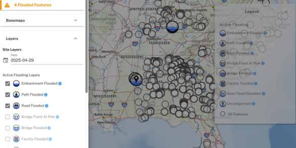
The Real-Time Flood Impacts (RTFI) Map displays the locations (called “Flood Impact Locations”) where the USGS has measured the height of critical safety or infrastructure features that may be vulnerable to flood impacts. Some examples of flood impact locations include stream and river embankments; roads and bridges; pedestrian paths; buildings; and more.
Real-Time Flood Impacts API
Real-Time Flood Impacts API
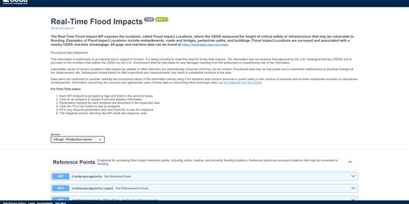
The Real-Time Flood Impacts (RTFI) API exposes the locations, called Flood Impact Locations, where the USGS measured the height of critical safety or infrastructure that may be vulnerable to flooding. Developers can now access real-time flood impact data programmatically through this REST API.
Science and Products

Providing Major Storm and Short-Term Flood Event Data
During major storms or other short-term events, the USGS collects streamflow and additional data to help document high-water events. This data is uploaded to the Short-Term Network (STN) for long-term archival and served out to the public through the Flood Event Viewer (FEV) which provides convenient, map-based access to downloadable event-based data.

ICE! Ice Jam Hazard Mobile-Friendly Website
Ice jams are a major hazard. The project team worked with the US Army Corps of Engineers, National Weather Service, Silver Jackets, and USGS stakeholders to develop a mobile-friendly prototype of an Ice Jam Hazard website and reporting system. The prototype shows how ice jam conditions can be recorded nationwide. The public can view and download ice jam information. Historic ice jam...

Lauren Privette
Lauren Privette holds a large ice block from a frozen lake at Treehaven education center in northern Wisconsin.
Science and Products
Providing Major Storm and Short-Term Flood Event Data
During major storms or other short-term events, the USGS collects streamflow and additional data to help document high-water events. This data is uploaded to the Short-Term Network (STN) for long-term archival and served out to the public through the Flood Event Viewer (FEV) which provides convenient, map-based access to downloadable event-based data.
ICE! Ice Jam Hazard Mobile-Friendly Website
Ice jams are a major hazard. The project team worked with the US Army Corps of Engineers, National Weather Service, Silver Jackets, and USGS stakeholders to develop a mobile-friendly prototype of an Ice Jam Hazard website and reporting system. The prototype shows how ice jam conditions can be recorded nationwide. The public can view and download ice jam information. Historic ice jam...
Lauren Privette
Lauren Privette holds a large ice block from a frozen lake at Treehaven education center in northern Wisconsin.
Lauren Privette holds a large ice block from a frozen lake at Treehaven education center in northern Wisconsin.