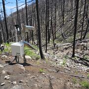
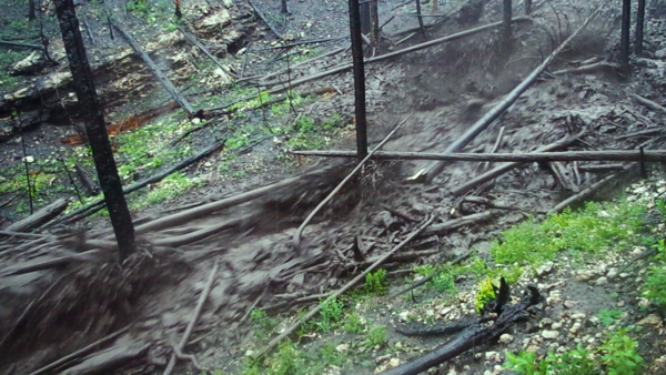
A landslide monitoring station within the footprint of the 2016 Fish Fire in the San Gabriel Mountains of southern California. The station collects surface and subsurface data to monitor and detect changes in local hillslope hydrologic conditions.
Olivia Hoch
Olivia is a Geologist in the Landslide Hazard Program in Golden, CO.
Professional Experience
2022 – present, Geologist, USGS Geologic Hazards Science Center
Education and Certifications
MS, Geoscience, University of Arizona
BA, Earth Science, Vassar College
Science and Products
Postfire Landslide Monitoring Station: “Las Lomas” (2016 Fish Fire) near Duarte, California
Postfire Landslide Monitoring Station: “Maria Ygnacio” (2019 Cave Fire) near Santa Barbara, California
Postfire Landslide Monitoring Station: "Chips" (2021 Dixie Fire) near Belden, CA
Postfire Landslide Monitoring Station: "Chambers" (2021 Dixie Fire) near Belden, CA
Seattle Area, Washington
Preliminary Landslide Inventory for Landslides Triggered by Hurricane Helene (September 2024)
Imagery and digital surface model for the Slumgullion landslide, Lake City, Colorado, June 3, 2024
Rainfall, Video, and Geophone Data from the Hermit's Peak/ Calf Canyon Fire Burn Area, New Mexico, June 2022 to June 2024
Rainfall, Volumetric soil-water content, Video, and Geophone Data from the Calwood Fire Burn Area, Colorado, April 2021 to November 2023
Tadpole Fire Debris Flow and Wood Collector Measurements May 2021
Tadpole Fire Field Measurements following the 8 September 2020 Debris Flow, Gila National Forest, NM
Post-wildfire debris-flow monitoring data, 2019 Woodbury Fire, Superstition Mountains, Arizona, USA November 2019 to February 2020
A landslide monitoring station within the footprint of the 2016 Fish Fire in the San Gabriel Mountains of southern California. The station collects surface and subsurface data to monitor and detect changes in local hillslope hydrologic conditions.
Characteristics of debris-flow-prone watersheds and debris-flow-triggering rainstorms following the Tadpole Fire, New Mexico, USA
The influence of large woody debris on post-wildfire debris flow sediment storage
Science and Products
Postfire Landslide Monitoring Station: “Las Lomas” (2016 Fish Fire) near Duarte, California
Postfire Landslide Monitoring Station: “Maria Ygnacio” (2019 Cave Fire) near Santa Barbara, California
Postfire Landslide Monitoring Station: "Chips" (2021 Dixie Fire) near Belden, CA
Postfire Landslide Monitoring Station: "Chambers" (2021 Dixie Fire) near Belden, CA
Seattle Area, Washington
Preliminary Landslide Inventory for Landslides Triggered by Hurricane Helene (September 2024)
Imagery and digital surface model for the Slumgullion landslide, Lake City, Colorado, June 3, 2024
Rainfall, Video, and Geophone Data from the Hermit's Peak/ Calf Canyon Fire Burn Area, New Mexico, June 2022 to June 2024
Rainfall, Volumetric soil-water content, Video, and Geophone Data from the Calwood Fire Burn Area, Colorado, April 2021 to November 2023
Tadpole Fire Debris Flow and Wood Collector Measurements May 2021
Tadpole Fire Field Measurements following the 8 September 2020 Debris Flow, Gila National Forest, NM
Post-wildfire debris-flow monitoring data, 2019 Woodbury Fire, Superstition Mountains, Arizona, USA November 2019 to February 2020
A landslide monitoring station within the footprint of the 2016 Fish Fire in the San Gabriel Mountains of southern California. The station collects surface and subsurface data to monitor and detect changes in local hillslope hydrologic conditions.