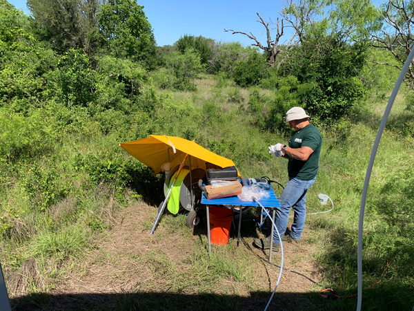
Patty Ging is a hydrologist with the U.S. Geological Survey (USGS) in Austin, TX. Her interests include various water-quality studies.
Patty's first project with the USGS combined with her masters degree work was on the Bull Creek watershed in the Austin, TX area which was evaluating stream water quality with respect to development. After completing masters degree, she joined the National Water Quality Assessment (NAWQA) program mainly dealing with surface water quality in the South-Central Texas study area and the Trinity River study area. She has been involved in many aspects of the NAWQA program including data management and regional analysis of surface water quality. Patty now oversees all the NAWQA work in Texas including surface water and ground water sampling.
Career Highlights
Use of nitrate isotopes to determine sources of nutrients in small urban watersheds
Water quality studies throughout the state of Texas
Comparison of water quality with two sampling procedures
Organic Compounds in stream water used for public supply
SPARROW modeling of nutrients to the Gulf of Mexico
Water quality in areas overlying hydrocarbon production areas in Texas
Education and Certifications
Patty received a bachelors (1991) and masters degree (1995) in Geology from the University of Texas in Austin.
Science and Products
National Water-Quality Assessment Project in Texas - Groundwater Activities
National Water-Quality Assessment Project in Texas - Surface Water Activities
Edwards Aquifer Studies in Texas
Chemical Composition of Bed Sediment and Water Samples Collected in the Houston Ship Channel or Patrick Bayou outlet near the Patrick Bayou Superfund Site, Deer Park, Texas, 2021
Water-Quality and Depth to Water for Groundwater Wells Primarily Completed in the Ogallala Aquifer within the North Plains Groundwater Conservation District, Texas Panhandle, 2012–13 and 2019–20
Water-Quality Data and Geophysical Logs for Determination of Saline Groundwater in Selected Aquifers in Texas, 2021
Geochemical Analysis Results of Hueco Bolson Production Well Groundwater Samples - Transboundary Aquifer Assessment Program
Water Quality Data at Brazos River near Rosharon, from July to December 2017-A period that includes the Landfall of Hurricane Harvey
Depth to water and water quality in groundwater wells in the Ogallala aquifer within the North Plains Groundwater Conservation District, Texas Panhandle, 2019–20, and comparison to 2012–13 conditions
Hydrogeologic framework, geochemistry, groundwater-flow system, and aquifer hydraulic properties used in the development of a conceptual model of the Ogallala, Edwards-Trinity (High Plains), and Dockum aquifers in and near Gaines, Terry, and Yoakum Counti
Geochemical assessment of the Hueco Bolson, New Mexico and Texas, 2016–17
Water-quality comparison of the Gulf Coast aquifer system at various scales in Texas from National Water-Quality Assessment groundwater studies, 2013–15
Water-quality comparison of the Gulf Coast aquifer system and Carrizo-Wilcox aquifer in Texas from National Water-Quality Assessment Project Principal Aquifer Surveys, 2013 and 2015
Pecos River Basin salinity assessment, Santa Rosa Lake, New Mexico, to the confluence of the Pecos River and the Rio Grande, Texas, 2015
Methane and benzene in drinking-water wells overlying the Eagle Ford, Fayetteville, and Haynesville Shale hydrocarbon production areas
The National Water-Quality Assessment (NAWQA) Program planned monitoring and modeling activities for Texas, 2013–23
Sources and Delivery of Nutrients to the Northwestern Gulf of Mexico from Streams in the South-Central United States
Geochemical evolution processes and water-quality observations based on results of the National Water-Quality Assessment Program in the San Antonio segment of the Edwards aquifer, Texas, 1996-2006
Organic compounds in Elm Fork Trinity River water used for public supply near Carrollton, Texas, 2002–05
Comparison of temperature, specific conductance, pH, and dissolved oxygen at selected basic fixed sites in south-central Texas, 1996-98
Science and Products
- Science
National Water-Quality Assessment Project in Texas - Groundwater Activities
The USGS National Water-Quality Assessment (NAWQA) Project was established by Congress in 1992 to answer the following question:What is the status of the Nation’s water quality and is it getting better or worse?Since 1992, NAWQA has been a primary source of nationally consistent data and information on the quality of the Nation’s streams and groundwater. Data and information obtained from...National Water-Quality Assessment Project in Texas - Surface Water Activities
The USGS National Water-Quality Assessment (NAWQA) Project was established by Congress in 1992 to answer the following question:What is the status of the Nation’s water quality and is it getting better or worse? Since 1992, NAWQA has been a primary source of nationally consistent data and information on the quality of the Nation’s streams and groundwater. Data and information obtained from...Edwards Aquifer Studies in Texas
The Edwards aquifer in south-central Texas is one of the most productive aquifers in the Nation and is the primary source of water for the rapidly growing San Antonio area. Springs issuing from the Edwards aquifer provide habitat for several threatened and endangered species, serve as locations for recreational activities, and supply downstream users. The USGS Oklahoma-Texas Water Science Center... - Data
Chemical Composition of Bed Sediment and Water Samples Collected in the Houston Ship Channel or Patrick Bayou outlet near the Patrick Bayou Superfund Site, Deer Park, Texas, 2021
Patrick Bayou, a section of the Houston Ship Channel near Deer Park, Texas, has accumulated permitted industrial wastewater discharges, municipal wastewater treatment plant effluent, and stormwater runoff from adjacent industrial facilities and nearby urban and residential areas. These discharges are suspected to be the primary sources of the sediment contamination in the Patrick Bayou section ofWater-Quality and Depth to Water for Groundwater Wells Primarily Completed in the Ogallala Aquifer within the North Plains Groundwater Conservation District, Texas Panhandle, 2012–13 and 2019–20
The Ogallala aquifer is contained in the Tertiary-age Ogallala Formation in the Texas Panhandle and is the primary water-bearing hydrogeologic unit of the High Plains aquifer system. The Ogallala aquifer is the primary source of water used for agricultural and municipal purposes in the Texas Panhandle. The Dockum aquifer is contained in the formations that compose the Triassic-age Dockum Group andWater-Quality Data and Geophysical Logs for Determination of Saline Groundwater in Selected Aquifers in Texas, 2021
The availability of groundwater-quality data along with geophysical information for relatively deep wells (wells generally more than 300 feet deep) containing saline water (dissolved-solids concentrations greater than 2,000 milligrams per liter)) is limited throughout the state of Texas. Water-quality samples are important for calibrating estimates of groundwater salinity derived from geophysicalGeochemical Analysis Results of Hueco Bolson Production Well Groundwater Samples - Transboundary Aquifer Assessment Program
The Transboundary Aquifer Assessment Act was established to systematically assess priority aquifers along the U.S.-Mexico international boundary. The priority aquifers that were specified include the Hueco-Mesilla Bolsons aquifer in Texas and New Mexico and its counterpart in Mexico, the Conejos-Medanos Aquifer system, and the Santa Cruz and San Pedro aquifers in Arizona (Texas Water Development BWater Quality Data at Brazos River near Rosharon, from July to December 2017-A period that includes the Landfall of Hurricane Harvey
In late August and early September 2017, Hurricane Harvey made landfall on the southeastern coastline of Texas and produced a record amount of rainfall, leading to widespread flooding. From August 25 through September 1, 2017, some areas in southeastern Texas received more than 60 inches of rain with large areas receiving at least 40 inches of rain. Hurricane Harvey was the largest rainfall event - Multimedia
- Publications
Filter Total Items: 24
Depth to water and water quality in groundwater wells in the Ogallala aquifer within the North Plains Groundwater Conservation District, Texas Panhandle, 2019–20, and comparison to 2012–13 conditions
The Ogallala aquifer is the primary source of water for agricultural and municipal purposes in the Texas Panhandle. Because most of the groundwater in the Texas Panhandle is withdrawn from the Ogallala aquifer, information on the quality of groundwater in the Ogallala aquifer in this part of Texas is useful for resource characterization. During 2012–13, the U.S. Geological Survey in cooperation wiAuthorsCraig A. Mobley, Patricia B. GingHydrogeologic framework, geochemistry, groundwater-flow system, and aquifer hydraulic properties used in the development of a conceptual model of the Ogallala, Edwards-Trinity (High Plains), and Dockum aquifers in and near Gaines, Terry, and Yoakum Counti
In 2014, the U.S. Geological Survey, in cooperation with Llano Estacado Underground Water Conservation District, Sandy Land Underground Water Conservation District, and South Plains Underground Water Conservation District (hereinafter referred to collectively as the “UWCDs”), began a multiphase study in and near Gaines, Terry, and Yoakum Counties, Texas, to develop a regional conceptual model of tAuthorsAndrew P. Teeple, Patricia B. Ging, Jonathan V. Thomas, David S. Wallace, Jason D. PayneGeochemical assessment of the Hueco Bolson, New Mexico and Texas, 2016–17
Understanding groundwater quality in transboundary aquifers like the Hueco Bolson is important for the 2.7 million people along the United States and Mexico border living in and near the combined metropolitan areas of Ciudad Juárez, Mexico, and El Paso, Texas, who rely on groundwater for water supply. To better understand water-quality conditions in the Mexico–New Mexico–Texas transboundary area,AuthorsPatricia B. Ging, Delbert G. Humberson, Scott J. IkardWater-quality comparison of the Gulf Coast aquifer system at various scales in Texas from National Water-Quality Assessment groundwater studies, 2013–15
One of the objectives of the U.S. Geological Survey National Water-Quality Assessment (NAWQA) Project is to assess groundwater quality in aquifers that are important sources of drinking water such as the coastal lowlands aquifer system, which is often referred to in Texas as the “Gulf Coast aquifer system.” The Gulf Coast aquifer system extends from Louisiana to Mexico and is a source of groundwatAuthorsPatricia B. GingWater-quality comparison of the Gulf Coast aquifer system and Carrizo-Wilcox aquifer in Texas from National Water-Quality Assessment Project Principal Aquifer Surveys, 2013 and 2015
The U.S. Geological Survey’s National Water-Quality Assessment (NAWQA) Project assessed the quality of groundwater in aquifers that are important sources of drinking water in the United States. One major aquifer in Texas that was assessed by NAWQA in 2013 is the coastal lowlands aquifer system, which is often referred to in Texas as the “Gulf Coast aquifer system.” The coastal lowlands aquifer sysAuthorsPatricia B. GingPecos River Basin salinity assessment, Santa Rosa Lake, New Mexico, to the confluence of the Pecos River and the Rio Grande, Texas, 2015
The elevated salinity of the Pecos River throughout much of its length is of paramount concern to water users and water managers. Dissolved-solids concentrations in the Pecos River exceed 3,000 milligrams per liter in many of its reaches in the study area, from Santa Rosa Lake, New Mexico, to the confluence of the Pecos River with the Rio Grande, Texas. The salinity of the Pecos River increases doAuthorsNatalie A. Houston, Jonathan V. Thomas, Patricia B. Ging, Andrew P. Teeple, Diana E. Pedraza, David S. WallaceMethane and benzene in drinking-water wells overlying the Eagle Ford, Fayetteville, and Haynesville Shale hydrocarbon production areas
Water wells (n = 116) overlying the Eagle Ford, Fayetteville, and Haynesville Shale hydrocarbon production areas were sampled for chemical, isotopic, and groundwater-age tracers to investigate the occurrence and sources of selected hydrocarbons in groundwater. Methane isotopes and hydrocarbon gas compositions indicate most of the methane in the wells was biogenic and produced by the CO2 reductionAuthorsPeter B. McMahon, Jeannie R. B. Barlow, Mark A. Engle, Kenneth Belitz, Patricia B. Ging, Andrew G. Hunt, Bryant C. Jurgens, Yousif K. Kharaka, Roland W. Tollett, Timothy M. KresseThe National Water-Quality Assessment (NAWQA) Program planned monitoring and modeling activities for Texas, 2013–23
The U.S. Geological Survey’s (USGS) National Water-Quality Assessment (NAWQA) Program was established by Congress in 1992 to answer the following question: What is the status of the Nation’s water quality and is it getting better or worse? Since 1992, NAWQA has been a primary source of nationally consistent data and information on the quality of the Nation’s streams and groundwater. Data and inforAuthorsPatricia GingSources and Delivery of Nutrients to the Northwestern Gulf of Mexico from Streams in the South-Central United States
SPAtially Referenced Regressions On Watershed attributes (SPARROW) models were developed to estimate nutrient inputs [total nitrogen (TN) and total phosphorus (TP)] to the northwestern part of the Gulf of Mexico from streams in the South‐Central United States (U.S.). This area included drainages of the Lower Mississippi, Arkansas‐White‐Red, and Texas‐Gulf hydrologic regions. The models were standaAuthorsRichard A. Rebich, Natalie A. Houston, Scott V. Mize, Daniel Pearson, Patricia B. Ging, Hornig C. EvanGeochemical evolution processes and water-quality observations based on results of the National Water-Quality Assessment Program in the San Antonio segment of the Edwards aquifer, Texas, 1996-2006
As part of the National Water-Quality Assessment Program, the U.S. Geological Survey collected and analyzed groundwater samples during 1996-2006 from the San Antonio segment of the Edwards aquifer of central Texas, a productive karst aquifer developed in Cretaceous-age carbonate rocks. These National Water-Quality Assessment Program studies provide an extensive dataset of groundwater geochemistryAuthorsMaryLynn Musgrove, Lynne Fahlquist, Natalie A. Houston, Richard J. Lindgren, Patricia B. GingOrganic compounds in Elm Fork Trinity River water used for public supply near Carrollton, Texas, 2002–05
Organic compounds studied in this U.S. Geological Survey (USGS) assessment generally are man-made, including pesticides, solvents, gasoline hydrocarbons, personal-care and domestic-use products, refrigerants, and propellants. A total of 103 of 277 compounds were detected at least once among the 30 samples of source water for a community water system on the Elm Fork Trinity River near Carrollton, TAuthorsPatricia B. Ging, Gregory C. Delzer, Pixie A. HamiltonComparison of temperature, specific conductance, pH, and dissolved oxygen at selected basic fixed sites in south-central Texas, 1996-98
One component of the surface-water part of the U.S. Geological Survey National Water-Quality Assessment Program is the use of continuous water-quality monitors to help characterize the spatial and temporal distribution of general water quality in relation to hydrologic conditions. During 1996-98, six continuous water-quality monitors in the South-Central Texas study unit collected water temperaturAuthorsPatricia B. Ging, Cassi L. Otero