
Sarah Dunn (Former Employee)
Science and Products
Conceptual hydrogeologic framework and groundwater budget near the southeastern part of Puget Sound, Washington Conceptual hydrogeologic framework and groundwater budget near the southeastern part of Puget Sound, Washington
More than 1 million people live within the active model area (AMA) in the southeastern part of the lowlands surrounding Puget Sound, or Puget Lowland, Washington, and groundwater is the source for approximately one-half of their public, domestic, and irrigation water demands. The 887-square-mile AMA, located in King and Pierce Counties, represents the area of analysis for the conceptual
Authors
Wendy B. Welch, Valerie A.L. Bright, Andrew S. Gendaszek, Sarah B. Dunn, Alexander O. Headman, Elisabeth T. Fasser
Predicting probabilities of late summer surface flow presence in a glaciated mountainous headwater region Predicting probabilities of late summer surface flow presence in a glaciated mountainous headwater region
Accurate mapping of streams that maintain surface flow during annual baseflow periods in mountain headwater streams is important for informing water availability for human consumption and is a fundamental determinant of in-channel conditions for stream-dwelling organisms. Yet accurate mapping that captures local spatial variability and associated local controls on surface flow presence...
Authors
Kristin L. Jaeger, Roy Sando, Sarah B. Dunn, Andrew S. Gendaszek
Changes in suspended-sediment yields under divergent land-cover disturbance histories: A comparison of two large watersheds, Olympic Mountains, USA Changes in suspended-sediment yields under divergent land-cover disturbance histories: A comparison of two large watersheds, Olympic Mountains, USA
Improvements in timber harvest practices and reductions in harvest volumes over the past half century are commonly presumed to have reduced sediment loads in many western US rivers. However, direct assessments in larger watersheds are relatively sparse. Here, we compare 2019–21 sediment concentrations against those of the late 1970s in the Bogachiel and Calawah River watersheds, adjacent...
Authors
Kristin L. Jaeger, Scott W. Anderson, Sarah B. Dunn
Groundwater and surface-water data collection for the Walla Walla River Basin, Washington, 2018–22 Groundwater and surface-water data collection for the Walla Walla River Basin, Washington, 2018–22
The semi-arid Walla Walla River Basin (WWRB) spans 1777 square miles in the states of Washington and Oregon and supports a diverse agricultural region as well as cities and rural communities that are partially reliant on groundwater. Historically, surface water and groundwater data have been collected in the WWRB by several entities including federal, state, local, and tribal governments
Authors
Elisabeth T. Fasser, Sarah B. Dunn
Beyond streamflow: Call for a national data repository of streamflow presence for streams and rivers in the United States Beyond streamflow: Call for a national data repository of streamflow presence for streams and rivers in the United States
Observations of the presence or absence of surface water in streams are useful for characterizing streamflow permanence, which includes the frequency, duration, and spatial extent of surface flow in streams and rivers. Such data are particularly valuable for headwater streams, which comprise the vast majority of channel length in stream networks, are often non-perennial, and are...
Authors
Kristin L. Jaeger, Konrad Hafen, Jason B. Dunham, Ken M. Fritz, Stephanie K. Kampf, Theodore B. Barnhart, Kendra E. Kaiser, Roy Sando, Sherri L Johnson, Ryan R. McShane, Sarah Beth Dunn
Non-USGS Publications**
Dunn, S.B., Rathburn, S.L., Wohl, E., n.d. Post-fire sediment attenuation in beaver ponds, Rocky Mountains, CO and WY, USA. Earth Surface Processes and Landforms n/a. https://doi.org/10.1002/esp.5970
Persico, L.P., McFadden, L.D., McAuliffe, J.R., Rittenour, T.M., Stahlecker, T.E., Dunn, S.B., Brody, S.A.T., 2021. Late Quaternary geochronologic record of soil formation and erosion: Effects of climate change on Mojave Desert hillslopes (Nevada, USA). Geology 50: 54–59. DOI: 10.1130/G49270.1. url: https://doi.org/10.1130/G49270.1
Wohl, E., Uno, H., Dunn, S.B., Kemper, J.T., Marshall, A., Means-Brous, M., Scamardo, J.E., Triantafillou, S.P., n.d. Why wood should move in rivers. River Research and Applications n/a. DOI: 10.1002/rra.4114. url: https://doi.org/10.1002/rra.4114
Wohl, E., Rathburn, S., Dunn, S., Iskin, E., Katz, A., Marshall, A., Means-Brous, M., Scamardo, J., Triantafillou, S., Uno, H., 2024. Geomorphic context in process-based river restoration. River Research and Applications 40, 322–340. https://doi.org/10.1002/rra.4236
**Disclaimer: The views expressed in Non-USGS publications are those of the author and do not represent the views of the USGS, Department of the Interior, or the U.S. Government.
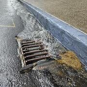
Integrating Stormwater Drainage into USGS StreamStats Application for the Duwamish and Lower Green River
The U.S. Geological Survey (USGS) is developing a Duwamish and Lower Green River Storm Drain StreamStats application to help communities and decision-makers address stormwater challenges in the Duwamish and lower Green River watershed. This free, publicly accessible tool will allow users to delineate stormwater drainage areas and calculate basin characteristics, supporting climate resiliency and...
Sediment computed tomography (CT) scans, photographs, and core-log descriptions from Conconully Reservoir, Okanogan County, WA, 2022-2023 Sediment computed tomography (CT) scans, photographs, and core-log descriptions from Conconully Reservoir, Okanogan County, WA, 2022-2023
This data release contains information on four sediment cores that were collected by the U.S. Geological Survey in Conconully Reservoir, Okanogan County, Washington, in June 2022 and October 2023. Data include the location each sediment core was collected, descriptions of the sediment profile of two of the cores (i.e., texture, color, structure, and visible constituents), photographs of...
Sediment and dissolved oxygen data to support fine sediment intrusion in Chinook salmon spawning gravels, Sauk River, Washington Sediment and dissolved oxygen data to support fine sediment intrusion in Chinook salmon spawning gravels, Sauk River, Washington
This Data Release contains supporting data to evaluate fine sediment infiltration into gravels in identified locations of Chinook spawning habitat at three sites on the Sauk River, located in western Washington. Fine sediment infiltration into the river substrate that salmonid fish species use to spawn has been shown to increase mortality during the incubation and pre-emergence phase...
Surface water presence field observation points for Mt. Rainier and surrounding area, WA, July 2018 - September 2020 Surface water presence field observation points for Mt. Rainier and surrounding area, WA, July 2018 - September 2020
This dataset includes spatial locations where surface water presence observations were collected during the late summer baseflow period in Mt. Rainier National Park and surrounding area in Washington State, July 2018 - September 2020. Stream flow status (continuous flow, discontinuous flow, and dry) were recorded using the FLOwPER (FLOw PERmanence) field survey available in the Survey...
Supporting data for and predictions from streamflow permanence modeling in Mount Rainier National Park and surrounding area, Washington, 2018-2020 Supporting data for and predictions from streamflow permanence modeling in Mount Rainier National Park and surrounding area, Washington, 2018-2020
This data release contains spatially gridded geospatial data (rasters), R scripts, and supporting files to run Random Forest models to predict the probability of late summer surface flow in Mount Rainier and surrounding area in Washington State for 2018–20. Gridded geospatial data that describes the physical conditions of Mount Rainier National Park and surrounding area are used to...
Supporting Spatial Data for Sediment Studies in the Bogachiel and Calawah River Watersheds, Washington Supporting Spatial Data for Sediment Studies in the Bogachiel and Calawah River Watersheds, Washington
This Data Release provides spatial data to support analysis of land cover change and channel width change in the Bogachiel and Calawah River basins, Washington. This supports a larger analysis that quantifies suspended-sediment yields for the two basins for water years 1977-1978 and more recently, for water years 2019-2021. Collectively the study evaluates influences of hydrology...
Supporting data for and predictions from streamflow permanence modeling in Mt. Rainier National Park and surrounding area, Washington, 2018-2020 Supporting data for and predictions from streamflow permanence modeling in Mt. Rainier National Park and surrounding area, Washington, 2018-2020
Note: this data release has been deprecated. Find the updated version here: https://doi.org/10.5066/P942QL23 In June, 2022, the Mount Rainier Streamflow Permanence model was revised to replace monthly climatic covariates with seven-month summaries to address peer-review comments related to inclusion of correlated covariates into the model. Replacement of the monthly covariates resulted...
Science and Products
Conceptual hydrogeologic framework and groundwater budget near the southeastern part of Puget Sound, Washington Conceptual hydrogeologic framework and groundwater budget near the southeastern part of Puget Sound, Washington
More than 1 million people live within the active model area (AMA) in the southeastern part of the lowlands surrounding Puget Sound, or Puget Lowland, Washington, and groundwater is the source for approximately one-half of their public, domestic, and irrigation water demands. The 887-square-mile AMA, located in King and Pierce Counties, represents the area of analysis for the conceptual
Authors
Wendy B. Welch, Valerie A.L. Bright, Andrew S. Gendaszek, Sarah B. Dunn, Alexander O. Headman, Elisabeth T. Fasser
Predicting probabilities of late summer surface flow presence in a glaciated mountainous headwater region Predicting probabilities of late summer surface flow presence in a glaciated mountainous headwater region
Accurate mapping of streams that maintain surface flow during annual baseflow periods in mountain headwater streams is important for informing water availability for human consumption and is a fundamental determinant of in-channel conditions for stream-dwelling organisms. Yet accurate mapping that captures local spatial variability and associated local controls on surface flow presence...
Authors
Kristin L. Jaeger, Roy Sando, Sarah B. Dunn, Andrew S. Gendaszek
Changes in suspended-sediment yields under divergent land-cover disturbance histories: A comparison of two large watersheds, Olympic Mountains, USA Changes in suspended-sediment yields under divergent land-cover disturbance histories: A comparison of two large watersheds, Olympic Mountains, USA
Improvements in timber harvest practices and reductions in harvest volumes over the past half century are commonly presumed to have reduced sediment loads in many western US rivers. However, direct assessments in larger watersheds are relatively sparse. Here, we compare 2019–21 sediment concentrations against those of the late 1970s in the Bogachiel and Calawah River watersheds, adjacent...
Authors
Kristin L. Jaeger, Scott W. Anderson, Sarah B. Dunn
Groundwater and surface-water data collection for the Walla Walla River Basin, Washington, 2018–22 Groundwater and surface-water data collection for the Walla Walla River Basin, Washington, 2018–22
The semi-arid Walla Walla River Basin (WWRB) spans 1777 square miles in the states of Washington and Oregon and supports a diverse agricultural region as well as cities and rural communities that are partially reliant on groundwater. Historically, surface water and groundwater data have been collected in the WWRB by several entities including federal, state, local, and tribal governments
Authors
Elisabeth T. Fasser, Sarah B. Dunn
Beyond streamflow: Call for a national data repository of streamflow presence for streams and rivers in the United States Beyond streamflow: Call for a national data repository of streamflow presence for streams and rivers in the United States
Observations of the presence or absence of surface water in streams are useful for characterizing streamflow permanence, which includes the frequency, duration, and spatial extent of surface flow in streams and rivers. Such data are particularly valuable for headwater streams, which comprise the vast majority of channel length in stream networks, are often non-perennial, and are...
Authors
Kristin L. Jaeger, Konrad Hafen, Jason B. Dunham, Ken M. Fritz, Stephanie K. Kampf, Theodore B. Barnhart, Kendra E. Kaiser, Roy Sando, Sherri L Johnson, Ryan R. McShane, Sarah Beth Dunn
Non-USGS Publications**
Dunn, S.B., Rathburn, S.L., Wohl, E., n.d. Post-fire sediment attenuation in beaver ponds, Rocky Mountains, CO and WY, USA. Earth Surface Processes and Landforms n/a. https://doi.org/10.1002/esp.5970
Persico, L.P., McFadden, L.D., McAuliffe, J.R., Rittenour, T.M., Stahlecker, T.E., Dunn, S.B., Brody, S.A.T., 2021. Late Quaternary geochronologic record of soil formation and erosion: Effects of climate change on Mojave Desert hillslopes (Nevada, USA). Geology 50: 54–59. DOI: 10.1130/G49270.1. url: https://doi.org/10.1130/G49270.1
Wohl, E., Uno, H., Dunn, S.B., Kemper, J.T., Marshall, A., Means-Brous, M., Scamardo, J.E., Triantafillou, S.P., n.d. Why wood should move in rivers. River Research and Applications n/a. DOI: 10.1002/rra.4114. url: https://doi.org/10.1002/rra.4114
Wohl, E., Rathburn, S., Dunn, S., Iskin, E., Katz, A., Marshall, A., Means-Brous, M., Scamardo, J., Triantafillou, S., Uno, H., 2024. Geomorphic context in process-based river restoration. River Research and Applications 40, 322–340. https://doi.org/10.1002/rra.4236
**Disclaimer: The views expressed in Non-USGS publications are those of the author and do not represent the views of the USGS, Department of the Interior, or the U.S. Government.
Integrating Stormwater Drainage into USGS StreamStats Application for the Duwamish and Lower Green River
The U.S. Geological Survey (USGS) is developing a Duwamish and Lower Green River Storm Drain StreamStats application to help communities and decision-makers address stormwater challenges in the Duwamish and lower Green River watershed. This free, publicly accessible tool will allow users to delineate stormwater drainage areas and calculate basin characteristics, supporting climate resiliency and...
Sediment computed tomography (CT) scans, photographs, and core-log descriptions from Conconully Reservoir, Okanogan County, WA, 2022-2023 Sediment computed tomography (CT) scans, photographs, and core-log descriptions from Conconully Reservoir, Okanogan County, WA, 2022-2023
This data release contains information on four sediment cores that were collected by the U.S. Geological Survey in Conconully Reservoir, Okanogan County, Washington, in June 2022 and October 2023. Data include the location each sediment core was collected, descriptions of the sediment profile of two of the cores (i.e., texture, color, structure, and visible constituents), photographs of...
Sediment and dissolved oxygen data to support fine sediment intrusion in Chinook salmon spawning gravels, Sauk River, Washington Sediment and dissolved oxygen data to support fine sediment intrusion in Chinook salmon spawning gravels, Sauk River, Washington
This Data Release contains supporting data to evaluate fine sediment infiltration into gravels in identified locations of Chinook spawning habitat at three sites on the Sauk River, located in western Washington. Fine sediment infiltration into the river substrate that salmonid fish species use to spawn has been shown to increase mortality during the incubation and pre-emergence phase...
Surface water presence field observation points for Mt. Rainier and surrounding area, WA, July 2018 - September 2020 Surface water presence field observation points for Mt. Rainier and surrounding area, WA, July 2018 - September 2020
This dataset includes spatial locations where surface water presence observations were collected during the late summer baseflow period in Mt. Rainier National Park and surrounding area in Washington State, July 2018 - September 2020. Stream flow status (continuous flow, discontinuous flow, and dry) were recorded using the FLOwPER (FLOw PERmanence) field survey available in the Survey...
Supporting data for and predictions from streamflow permanence modeling in Mount Rainier National Park and surrounding area, Washington, 2018-2020 Supporting data for and predictions from streamflow permanence modeling in Mount Rainier National Park and surrounding area, Washington, 2018-2020
This data release contains spatially gridded geospatial data (rasters), R scripts, and supporting files to run Random Forest models to predict the probability of late summer surface flow in Mount Rainier and surrounding area in Washington State for 2018–20. Gridded geospatial data that describes the physical conditions of Mount Rainier National Park and surrounding area are used to...
Supporting Spatial Data for Sediment Studies in the Bogachiel and Calawah River Watersheds, Washington Supporting Spatial Data for Sediment Studies in the Bogachiel and Calawah River Watersheds, Washington
This Data Release provides spatial data to support analysis of land cover change and channel width change in the Bogachiel and Calawah River basins, Washington. This supports a larger analysis that quantifies suspended-sediment yields for the two basins for water years 1977-1978 and more recently, for water years 2019-2021. Collectively the study evaluates influences of hydrology...
Supporting data for and predictions from streamflow permanence modeling in Mt. Rainier National Park and surrounding area, Washington, 2018-2020 Supporting data for and predictions from streamflow permanence modeling in Mt. Rainier National Park and surrounding area, Washington, 2018-2020
Note: this data release has been deprecated. Find the updated version here: https://doi.org/10.5066/P942QL23 In June, 2022, the Mount Rainier Streamflow Permanence model was revised to replace monthly climatic covariates with seven-month summaries to address peer-review comments related to inclusion of correlated covariates into the model. Replacement of the monthly covariates resulted...