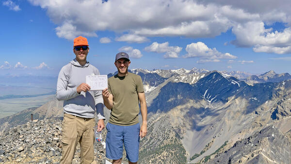
When you work for the USGS in Idaho, what do you do on the weekend? Climb USGS Peak, of course! Idaho Falls-based USGS hydrologic technicians Jeff Zingre and Tate Wilson-Johns celebrate on the summit of Idaho's 10th highest peak.
Tim Merrick
Tim Merrick is the Public Information Officer for the UGSS Idaho Water Science Center in Boise, Idaho. He manages center's communications, media relations, outreach, and publishing.
Prior to joining the USGS in 2005, Tim worked for more than two decades as a technical writer developing user and developer documentation for corporations including HP, Microsoft, Micron Technology, and Idaho Power Company.
Professional Experience
2005 - Present, Public Information Officer, Idaho Water Science Center, U.S. Geological Survey
2002 - 2005, Technical Writer, Micron Technology
Education and Certifications
M.L.I.S., 2008, University of Washington Information School
B.A. English, 1990, University of Arizona, Cum laude
Affiliations and Memberships*
National Association of Government Communicators
Public Relations Society of America
Northwest Science Writers Association
Science and Products
When you work for the USGS in Idaho, what do you do on the weekend? Climb USGS Peak, of course! Idaho Falls-based USGS hydrologic technicians Jeff Zingre and Tate Wilson-Johns celebrate on the summit of Idaho's 10th highest peak.
U.S. Geological Survey hydrologist Tyler King helps a citizen volunteer test a water sample for dissolved oxygen as part of the 2019 Watershed Watch in the lower Boise River watershed of southwestern Idaho. Watershed Watch is an annual citizen science event sponsored by the City of Boise. The USGS is an event co-sponsor.
USGS hydrologic technician Michael Allen collects streamflow data from the Boise River at streamgage station 13206000 using an acoustic Doppler current profiler.
Samples collected form coho salmon that will be used to develop environmental DNA (eDNA) assays for the species. Water samples from aquatic ecosystems are compared against the assays to identify the presence and location of species in those ecosystems.
Samples from various aquatic species and other material necessary to create environemntal DNA (eDNA) assays are stored at the Snake River Field Station in Boise. Water samples from aquatic ecosystems are compared against the assays to identify the presence and location of species in those ecosystems.
USGS hydrologic technicians Erin Murray (far left) and Russ Miller collect water-quality data from the Boise River with citizen volunteers as part of the 2014 Boise Watershed Watch. Watershed Watch is an annual community outreach effort of the City of Boise's WaterShed Environmental Education Center. The USGS is an annual event co-sponsor.
U.S. Geological Survey hydrographer Doug Ott inspects the gagehouse at streamgage stations 13317000, Salmon River at White Bird, Idaho, May 10, 2013. The flow at the gage was approximately 40,000 cubic feet per second at the time of this photo.
USGS biologist Dorene MacCoy and a group of citizen volunteers prepare to collect and record water-quality data as part of the October 27 Watershed Watch citizen science event on the Boise River in Boise, ID.
USGS biologist Dorene MacCoy and a group of citizen volunteers collect and record water-quality data as part of the October 27 Watershed Watch citizen science event on the Boise River in Boise, ID.
USGS biologist Dorene MacCoy helps citizen volunteers identify macroinvertebrates collected from the Boise River as part of the October 27 Watershed Watch citizen science event in Boise, ID.
USGS biologist Dorene MacCoy helps citizen volunteers test a water-quality sample as part of the October 27 Watershed Watch citizen science event on the Boise River in Boise, ID.
USGS biologist Dorene MacCoy helps a citizen volunteer record water-quality data as part of the October 27 Watershed Watch citizen science event on the Boise River in Boise, ID.
U.S. Geological Survey hydrologic technicians prepare to use an acoustic Doppler current profiler to measure streamflow on the Boise River in Boise's Veterans Memorial Park as part of a study of phosphorus mass balance.
U.S. Geological Survey hydrologic technicians use an acoustic Doppler current profiler to measure streamflow on the Boise River in Boise's Veterans Memorial Park as part of a study of phosphorus mass balance.
A U.S. Geological Survey hydrologic technician wades into the Boise River with an acoustic Doppler current profiler to measure streamflow in the river at Boise's Veterans Memorial Park, August 21, 2012, as part of a study of phosphorus mass balance.
U.S. Geological Survey hydrologic technicians use an acoustic Doppler current profiler to measure streamflow on the Boise River in Boise's Veterans Memorial Park as part of a study of phosphorus mass balance.
USGS scientists used this multiparameter display system attached to a water-quality sonde and the accompanying data sheet as they collected water-quality data from the lower Boise River near Veterans Memorial Parkway in Boise, ID.
Beginning April 26, the Boise River of southwestern Idaho reached flood stage. The USGS responded by installing three rapid deployment streamgages on bridges near Eagle, Star, and Parma, Idaho to provide additional information to emergency response teams. In this photo USGS hydrologic technicians install a rapid deployment streamgage on the U.S.
*Disclaimer: Listing outside positions with professional scientific organizations on this Staff Profile are for informational purposes only and do not constitute an endorsement of those professional scientific organizations or their activities by the USGS, Department of the Interior, or U.S. Government