U.S. flag

An official website of the United States government

Images

Images of Clear Lake Volcanic Field.

Filter Total Items: 34
A geologist in a blue shirt and khakis supports a basketball-sized chunk of lava on his knee. A bright white "rind" makes up about half of the chunk, surrounding a core of dark gray lava speckled with white crystals. A marker rests on the chunk for a sense of scale, and similar white chunks of lava make up the background of the photo.
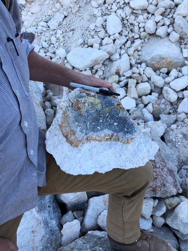
A heavily hydrothermally-altered sample of lava from the Clear Lake Volcanic Field

Geologists often break off the weathered surfaces of rocks in the field to get at the fresh, clean cores. This makes it easier to see the original mineralogy of the rock in question without oxidation, alteration, or other environmental impacts. USGS photo by D. Blatter

Geologists often break off the weathered surfaces of rocks in the field to get at the fresh, clean cores. This makes it easier to see the original mineralogy of the rock in question without oxidation, alteration, or other environmental impacts. USGS photo by D. Blatter

A geologist in tan pants, a blue button-down shirt and an orange hat stands with one foot on a boulder at the side of a road, holding up a baggie of rocks. Behind him the ground has been scraped bare by construction equipment.
Basalt, Clear Lake Volcanic Field

These freshly excavated boulders along Spruce Grove Road are basalt, which is an iron and magnesium-rich rock that’s fairly uncommon in the Clear Lake Volcanic Field.

These freshly excavated boulders along Spruce Grove Road are basalt, which is an iron and magnesium-rich rock that’s fairly uncommon in the Clear Lake Volcanic Field.

A male geologist in an orange ballcap and blue button-down shirt holds a rock hammer in one hand and a rock in the other.
Eruption Episode 3 rocks, Clear Lake Volcanic Field, California

Eruption episode 3 is the most voluminous in the history of the Clear Lake Volcanic Field. Episode 3 rocks are of intermediate composition, primarily dacite, and make up many of the topographic high points in the field, including Mt. Konocti, where this photo is taken.

Eruption episode 3 is the most voluminous in the history of the Clear Lake Volcanic Field. Episode 3 rocks are of intermediate composition, primarily dacite, and make up many of the topographic high points in the field, including Mt. Konocti, where this photo is taken.

This photo looks across an active rock quarry at a conical hill that has been mined, revealing a dark red interior
Clearlake Oaks cinder cone, Clear Lake Volcanic Field, California

Cinder cones (or scoria cones) are relatively small, steep-sided volcanoes that are constructed around a single vent when lava is ejected into the air, breaks into smaller pieces, and builds up around the sides of the vent. This photo is looking across the quarry which exposes the interior of a cinder cone east of Clearlake Oaks in the Clear Lake Volcanic Field.

Cinder cones (or scoria cones) are relatively small, steep-sided volcanoes that are constructed around a single vent when lava is ejected into the air, breaks into smaller pieces, and builds up around the sides of the vent. This photo is looking across the quarry which exposes the interior of a cinder cone east of Clearlake Oaks in the Clear Lake Volcanic Field.

A view on a clear day, looking down from a high volcanic peak at a cratered promontory in the blue waters of Clear Lake.
Buckingham Peninsula, Clear Lake, CA

Located at the midpoint of Clear Lake in Lake County, California, Buckingham Peninsula shows evidence of young explosive volcanism in the Clear Lake Volcanic Field. Little Borax Lake, enclosed within the Buckingham golf course, is a water-filled maar crater, as is Horseshoe Bay to its northeast. USGS photo by J. Ball.

Located at the midpoint of Clear Lake in Lake County, California, Buckingham Peninsula shows evidence of young explosive volcanism in the Clear Lake Volcanic Field. Little Borax Lake, enclosed within the Buckingham golf course, is a water-filled maar crater, as is Horseshoe Bay to its northeast. USGS photo by J. Ball.

Two USGS scientists  wearing USGS shirts and baseball caps stand next to a rusting wellhead pipe and concrete well casing on a gravel field. One holds a gas analyzer with tubing; the other takes notes on a yellow clipboard. A green valley and low mountain ridges rise in the background under a clear blue sky.
Sampling gas at Kelseyville, California's Gas Hill

USGS scientists Deb Bergfeld and Laura Clor collect samples of the gas from the old Gas Hill wellhead in Kelseyville, CA. USGS photo by Jen Lewicki.

USGS scientists Deb Bergfeld and Laura Clor collect samples of the gas from the old Gas Hill wellhead in Kelseyville, CA. USGS photo by Jen Lewicki.

Mount Konocti, a 1,312 m (4,305 ft) mountain on the eastern shore o...

Mt. Konocti erupted during the most recent stage of volcanism (01. Ma to 10,000 years ago), and a future eruption from the same site would be devastating to the nearby inhabitants.

Mount Konocti on the western shore of Clear Lake, California

Mount Konocti, a mostly dacitic composite cone, on the western shore of Clear Lake, California. Thurston Lake is in the foreground.

A sepia-toned historical photograph shows an open field with people standing near a row of wooden-framed well structures and pipes. A thin jet of gas or water sprays upward from two of the wells. Forested hills and a mountain rise in the background.
Kelseyville Gas Wells, ca.1910

Photograph of men at the Kelseyville Gas Wells, ca.1910, by M. Rieder. Courtesy of California Historical Society Collection, University of Southern California Digital Libraries. 

Photograph of men at the Kelseyville Gas Wells, ca.1910, by M. Rieder. Courtesy of California Historical Society Collection, University of Southern California Digital Libraries. 

Was this page helpful?