
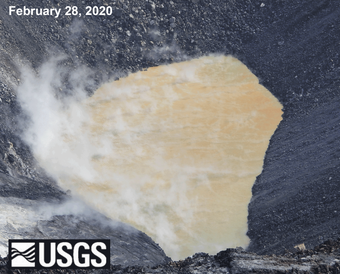
Ponded water first appeared at the bottom of Halema‘uma‘u crater at the summit of Kīlauea Volcano in late July 2019. The pond slowly deepened until December 20, 2020, when an eruption from the crater wall sent lava pouring into the lake, which caused it to boil off.


A water lake at Kīlauea summit, July 2019–December 2020
A water lake was present within Halema‘uma‘u, a crater in the summit caldera of Kīlauea, from July 2019 until December 2020. Scientists of the U.S. Geological Survey Hawaiian Volcano Observatory (HVO) monitored growth of this water lake, which was significant for its potential hazard implications and for being the largest volume of water observed within Kīlauea caldera in at least 200 years. The water lake was quickly boiled away by lava and replaced by a lava lake when fissures opened in the wall of Halema‘uma‘u on the evening of December 20, 2020.
Appearance of the water lake
A large eruption occurred in lower East Rift Zone at Kīlauea during the summit of 2018. As the eruption progressed, depleting the shallow magma reservoir at the summit of Kīlauea, the unsupported roof of part of the reservoir collapsed, deepening Halema‘uma‘u and adjacent parts of the caldera floor. Halema‘uma‘u became a pit more than 1,600 feet (500 meters) deeper.
Geophysical surveys have shown that water lies beneath the surface Kīlauea’s summit. A research well in the southern part of Kīlauea’s caldera (drilled in 1973) with a depth of 1.2 km (0.7 miles), contains 80–85°Celsius (176–185°Fahrenheit) water at an elevation similar to that of Halema‘uma‘u after the 2018 summit collapse.
HVO scientists hypothesized that water could eventually become visible on the surface given the depth of Halema‘uma‘u relative to the elevation of the local water table. Indeed, ponded water was first observed at the base of Halema‘uma‘u on July 25, 2019, during a routine overflight of Kīlauea summit. At first so small that it was barely identifiable as water, the pond slowly deepened and grew, ultimately becoming a lake more than eight acres (three hectares) in surface area and more than 50 meters (164 feet) deep.
Water lake growth, monitoring, and characterization
HVO staff monitored the Halema‘uma‘u water lake over the 17 months that it was present. The existing HVO geophysical monitoring network at Kīlauea summit, consisting of instruments to monitor summit seismicity, ground deformation, and volcanic gas emissions, was supplemented by other techniques to track the development of the lake. Webcams provided near-real-time visual and thermal imagery of the water lake to track color, circulation, and temperature. Field visits to the caldera rim collected lake-surface elevation measurements to derive rise rates and lake depth. Aerial surveys collected imagery for modeling lake surface area and volume. Unoccupied Aircraft Systems (UAS) flights collected water samples.
Visual and thermal imagery provided insight into water lake color, circulation, and temperature over time. Initially, the lake was predominantly bluish-green in color, but it became more orange-brown as it grew. Distinct boundaries often separated zones of different color, which sometimes coincided with temperature—and possibly chemical—differences, indicating the influx of warmer groundwater. Lake surface temperatures did not fluctuate greatly, remaining within the range of 70–85 degrees Celsius (158–185 degrees Fahrenheit); these hot temperatures indicated that the water lake was being heated by the volcano’s magmatic system.
Lake surface level was monitored and tracked by HVO geologists using a laser rangefinder. By measuring the vertical distance between the lake surface and a spot of known elevation, lake depth could be derived. Initially, the lake level rose approximately 0.75 meters (2.5 feet) each week, though that rise rate gradually slowed; by December 2020, the lake had reached a depth of approximately 50 meters (164 feet).
During overflights of Kīlauea summit, HVO scientists collected aerial imagery used to create models of the lake from which more detailed surface area and volume measurements could be made. By September 2020 (the last aerial survey prior to the lake’s disappearance), the water lake had grown to more than eight acres (three hectares) in surface area and nearly one million cubic meters (over 250 million gallons) in volume—equivalent to about 400 Olympic-sized swimming pools.
With permission from Hawai‘i Volcanoes National Park, and in consultation with the their Kūpuna council group, which includes Native Hawaiian organizations and individuals, as well as other interested parties, the water lake was sampled three times via UAS: in October 2019, January 2020, and October 2020. UAS were piloted down to the lake surface from the crater rim, over a kilometer away. Isotopic analyses of the water samples indicated the source of the water to be rain that percolated down through rocks to become groundwater at the summit of Kīlauea. However, the lake water chemistry differed from groundwater samples obtained at the nearby well. The lake water was mildly acidic, with a pH of about 4, likely due to dissolved sulfur deposits within the collapsed crater and dissolved volcanic gases (carbon dioxide—CO2, sulfur dioxide—SO2, hydrogen sulfide—H2S, hydrogen chloride—HCl, and hydrogen fluoride—HF) from magma below. These chemicals allowed the water to react with basaltic rocks in the crater wall. Iron, calcium, and sulfate, common in the wall, combined to form minerals that precipitated from the lake water and contributed to its varied colors, ranging from green to orange to brown. Occasionally, solid material was visible floating on the surface of the lake, though the material was never sampled or identified.
Significance of the water lake
The large body of water at the summit of Kīlauea was significant for being unprecedented in recent history and for the eruptive implications of its presence.
Though groundwater below the surface in the summit region of Kīlauea has been well-documented by past geophysical studies, a water lake had not been observed on the surface within the summit caldera or Halema‘uma‘u for at least the past 200 years. Native Hawaiian chants and oral traditions provide insight into past volcanic activity, chronicling Pele—the volcano deity whose home is Halema‘uma‘u at the summit of Kīlauea. Conflicts between Pele and other deities, including Kamapua‘a (a pig deity) and Hi‘iakaikapoliopele (Hi‘iaka—Pele’s younger sister), suggest that she was threatened by water in the past. In one chant, Hi‘iaka digs deeply beneath Kīlauea’s summit eventually refraining from penetrating a layer that would keep water from dousing Pele’s fires forever. This repeated digging through deeper layers, approaching the depth of water, is reminiscent of the 2018 Kīlauea summit collapse, which was so deep as to eventually expose the water table.
Deposits around Kīlauea’s summit hint at surface water partially contributing to an explosive period of Kīlauea’s history 200–500 years ago These deposits show textures and structures suggesting that magma interacted with water as it was erupting, perhaps causing, or contributing to, an eruption’s explosiveness. Though groundwater has always been present in the Kīlauea summit region, not all summit eruptions have been explosive. Previous non-explosive summit eruptions are thought to involve slowly-rising magma, enabling enough time to develop a “steam-sleeve” around the slowly rising magma. Alternatively, rapidly-rising magma encountering a large-enough body of water below or above the surface might trigger more explosive eruptions.
Crater lakes at other active volcanoes in the world have exhibited changes in color, chemistry, temperature, and circulation prior to eruptions. HVO scientists continuously monitored the appearance, temperature, and circulation of the water lake at Kīlauea summit for clues as to changes in hazards or precursors for a summit eruption. The water lake was one of the hottest monitored volcanic crater lakes on Earth, and it did exhibit differences in color and circulation throughout its existence, though none preceded the December 2020 eruption that ended the water lake. However, other geophysical monitoring data provided clues that an eruption was forthcoming, most notably summit inflation and seismicity associated with a likely shallow intrusion of magma in late November and early December 2020. The water lake did not exhibit any detectable changes associated with this intrusion, however, which occurred several weeks prior to the eruption in Halema‘uma‘u on the evening of December 20, 2020. The eruption, which began as fissures in the north and northwest wall of Halema‘uma‘u, generated a vigorous steam plume as the water lake was boiled off by lava pouring into it. Within an hour and a half, the water lake had been completely vaporized and replaced with a lava lake, thus ending a brief but unique period in Kīlauea’s recent history.
"Volcano Watch" articles about Kīlauea Summit Water
- "Water was in Kīlauea caldera before the 2018 summit collapse" – published Aug. 13, 2020
- "How hot is Kīlauea's summit water lake?" – published Aug. 6, 2020
- "Kīlauea Volcano's summit water lake is one-year old" – published Jul. 30, 2020
- "Scientists look to Hawaiian chants for mention of past crater lakes" – published Jan. 2, 2020
- "Pondering the pond: what Halema‘uma‘u water chemistry tells us" – published Nov. 14, 2019
- "What does water in Halema‘uma‘u mean?" – published Aug. 15, 2019
- "HVO now tracking ponds of water, not lava, at Kīlauea's summit" – published Aug. 9, 2019
- "Water or not water: that is (or was) the question" – published Aug. 1, 2019

Other USGS Kīlauea Summit Water Resources
- INFOGRAPHIC: One year of observations of Kīlauea's summit lake
- VIDEO: What's happening at Kīlauea Volcano's summit? – published Jan. 20, 2020
- VIDEO: Sampling the water in Halema‘uma‘u – Kīlauea Volcano – published Dec. 10, 2019
- VIDEO: Water appears in Halema‘uma‘u – Kīlauea Volcano – published Oct. 10, 2019

Notable Media Coverage of Kīlauea Summit Water
- Article published in September 2020: "From Lava to Water: A New Era at Kīlauea"—read it in Eos, the American Geophysical Union's science news publication
- On December 3, 2019, HVO research geologist Matt Patrick updated the Hawai‘i County Council on the Halema‘uma‘u crater lake at the summit of Kīlauea Volcano. The presentation, which was requested by the council, also summarized the implications of the crater lake for hazards. See the full presentation on Big Island Video News.
- On August 21, 2019, HVO geophysicist Jim Kauahikaua discussed the water pond in Halema‘uma‘u and what it means in a 19-minute "Island Conversations" interview aired on Hawai‘i radio stations. Listen to the full interview at B93/B97 or Big Island Video News, which includes a transcription.
Ponded water first appeared at the bottom of Halema‘uma‘u crater at the summit of Kīlauea Volcano in late July 2019. The pond slowly deepened until December 20, 2020, when an eruption from the crater wall sent lava pouring into the lake, which caused it to boil off.
A water lake at Kīlauea summit, July 2019–December 2020
A water lake was present within Halema‘uma‘u, a crater in the summit caldera of Kīlauea, from July 2019 until December 2020. Scientists of the U.S. Geological Survey Hawaiian Volcano Observatory (HVO) monitored growth of this water lake, which was significant for its potential hazard implications and for being the largest volume of water observed within Kīlauea caldera in at least 200 years. The water lake was quickly boiled away by lava and replaced by a lava lake when fissures opened in the wall of Halema‘uma‘u on the evening of December 20, 2020.
Appearance of the water lake
A large eruption occurred in lower East Rift Zone at Kīlauea during the summit of 2018. As the eruption progressed, depleting the shallow magma reservoir at the summit of Kīlauea, the unsupported roof of part of the reservoir collapsed, deepening Halema‘uma‘u and adjacent parts of the caldera floor. Halema‘uma‘u became a pit more than 1,600 feet (500 meters) deeper.
Geophysical surveys have shown that water lies beneath the surface Kīlauea’s summit. A research well in the southern part of Kīlauea’s caldera (drilled in 1973) with a depth of 1.2 km (0.7 miles), contains 80–85°Celsius (176–185°Fahrenheit) water at an elevation similar to that of Halema‘uma‘u after the 2018 summit collapse.
HVO scientists hypothesized that water could eventually become visible on the surface given the depth of Halema‘uma‘u relative to the elevation of the local water table. Indeed, ponded water was first observed at the base of Halema‘uma‘u on July 25, 2019, during a routine overflight of Kīlauea summit. At first so small that it was barely identifiable as water, the pond slowly deepened and grew, ultimately becoming a lake more than eight acres (three hectares) in surface area and more than 50 meters (164 feet) deep.
Water lake growth, monitoring, and characterization
HVO staff monitored the Halema‘uma‘u water lake over the 17 months that it was present. The existing HVO geophysical monitoring network at Kīlauea summit, consisting of instruments to monitor summit seismicity, ground deformation, and volcanic gas emissions, was supplemented by other techniques to track the development of the lake. Webcams provided near-real-time visual and thermal imagery of the water lake to track color, circulation, and temperature. Field visits to the caldera rim collected lake-surface elevation measurements to derive rise rates and lake depth. Aerial surveys collected imagery for modeling lake surface area and volume. Unoccupied Aircraft Systems (UAS) flights collected water samples.
Visual and thermal imagery provided insight into water lake color, circulation, and temperature over time. Initially, the lake was predominantly bluish-green in color, but it became more orange-brown as it grew. Distinct boundaries often separated zones of different color, which sometimes coincided with temperature—and possibly chemical—differences, indicating the influx of warmer groundwater. Lake surface temperatures did not fluctuate greatly, remaining within the range of 70–85 degrees Celsius (158–185 degrees Fahrenheit); these hot temperatures indicated that the water lake was being heated by the volcano’s magmatic system.
Lake surface level was monitored and tracked by HVO geologists using a laser rangefinder. By measuring the vertical distance between the lake surface and a spot of known elevation, lake depth could be derived. Initially, the lake level rose approximately 0.75 meters (2.5 feet) each week, though that rise rate gradually slowed; by December 2020, the lake had reached a depth of approximately 50 meters (164 feet).
During overflights of Kīlauea summit, HVO scientists collected aerial imagery used to create models of the lake from which more detailed surface area and volume measurements could be made. By September 2020 (the last aerial survey prior to the lake’s disappearance), the water lake had grown to more than eight acres (three hectares) in surface area and nearly one million cubic meters (over 250 million gallons) in volume—equivalent to about 400 Olympic-sized swimming pools.
With permission from Hawai‘i Volcanoes National Park, and in consultation with the their Kūpuna council group, which includes Native Hawaiian organizations and individuals, as well as other interested parties, the water lake was sampled three times via UAS: in October 2019, January 2020, and October 2020. UAS were piloted down to the lake surface from the crater rim, over a kilometer away. Isotopic analyses of the water samples indicated the source of the water to be rain that percolated down through rocks to become groundwater at the summit of Kīlauea. However, the lake water chemistry differed from groundwater samples obtained at the nearby well. The lake water was mildly acidic, with a pH of about 4, likely due to dissolved sulfur deposits within the collapsed crater and dissolved volcanic gases (carbon dioxide—CO2, sulfur dioxide—SO2, hydrogen sulfide—H2S, hydrogen chloride—HCl, and hydrogen fluoride—HF) from magma below. These chemicals allowed the water to react with basaltic rocks in the crater wall. Iron, calcium, and sulfate, common in the wall, combined to form minerals that precipitated from the lake water and contributed to its varied colors, ranging from green to orange to brown. Occasionally, solid material was visible floating on the surface of the lake, though the material was never sampled or identified.
Significance of the water lake
The large body of water at the summit of Kīlauea was significant for being unprecedented in recent history and for the eruptive implications of its presence.
Though groundwater below the surface in the summit region of Kīlauea has been well-documented by past geophysical studies, a water lake had not been observed on the surface within the summit caldera or Halema‘uma‘u for at least the past 200 years. Native Hawaiian chants and oral traditions provide insight into past volcanic activity, chronicling Pele—the volcano deity whose home is Halema‘uma‘u at the summit of Kīlauea. Conflicts between Pele and other deities, including Kamapua‘a (a pig deity) and Hi‘iakaikapoliopele (Hi‘iaka—Pele’s younger sister), suggest that she was threatened by water in the past. In one chant, Hi‘iaka digs deeply beneath Kīlauea’s summit eventually refraining from penetrating a layer that would keep water from dousing Pele’s fires forever. This repeated digging through deeper layers, approaching the depth of water, is reminiscent of the 2018 Kīlauea summit collapse, which was so deep as to eventually expose the water table.
Deposits around Kīlauea’s summit hint at surface water partially contributing to an explosive period of Kīlauea’s history 200–500 years ago These deposits show textures and structures suggesting that magma interacted with water as it was erupting, perhaps causing, or contributing to, an eruption’s explosiveness. Though groundwater has always been present in the Kīlauea summit region, not all summit eruptions have been explosive. Previous non-explosive summit eruptions are thought to involve slowly-rising magma, enabling enough time to develop a “steam-sleeve” around the slowly rising magma. Alternatively, rapidly-rising magma encountering a large-enough body of water below or above the surface might trigger more explosive eruptions.
Crater lakes at other active volcanoes in the world have exhibited changes in color, chemistry, temperature, and circulation prior to eruptions. HVO scientists continuously monitored the appearance, temperature, and circulation of the water lake at Kīlauea summit for clues as to changes in hazards or precursors for a summit eruption. The water lake was one of the hottest monitored volcanic crater lakes on Earth, and it did exhibit differences in color and circulation throughout its existence, though none preceded the December 2020 eruption that ended the water lake. However, other geophysical monitoring data provided clues that an eruption was forthcoming, most notably summit inflation and seismicity associated with a likely shallow intrusion of magma in late November and early December 2020. The water lake did not exhibit any detectable changes associated with this intrusion, however, which occurred several weeks prior to the eruption in Halema‘uma‘u on the evening of December 20, 2020. The eruption, which began as fissures in the north and northwest wall of Halema‘uma‘u, generated a vigorous steam plume as the water lake was boiled off by lava pouring into it. Within an hour and a half, the water lake had been completely vaporized and replaced with a lava lake, thus ending a brief but unique period in Kīlauea’s recent history.
"Volcano Watch" articles about Kīlauea Summit Water
- "Water was in Kīlauea caldera before the 2018 summit collapse" – published Aug. 13, 2020
- "How hot is Kīlauea's summit water lake?" – published Aug. 6, 2020
- "Kīlauea Volcano's summit water lake is one-year old" – published Jul. 30, 2020
- "Scientists look to Hawaiian chants for mention of past crater lakes" – published Jan. 2, 2020
- "Pondering the pond: what Halema‘uma‘u water chemistry tells us" – published Nov. 14, 2019
- "What does water in Halema‘uma‘u mean?" – published Aug. 15, 2019
- "HVO now tracking ponds of water, not lava, at Kīlauea's summit" – published Aug. 9, 2019
- "Water or not water: that is (or was) the question" – published Aug. 1, 2019
Other USGS Kīlauea Summit Water Resources
- INFOGRAPHIC: One year of observations of Kīlauea's summit lake
- VIDEO: What's happening at Kīlauea Volcano's summit? – published Jan. 20, 2020
- VIDEO: Sampling the water in Halema‘uma‘u – Kīlauea Volcano – published Dec. 10, 2019
- VIDEO: Water appears in Halema‘uma‘u – Kīlauea Volcano – published Oct. 10, 2019
Notable Media Coverage of Kīlauea Summit Water
- Article published in September 2020: "From Lava to Water: A New Era at Kīlauea"—read it in Eos, the American Geophysical Union's science news publication
- On December 3, 2019, HVO research geologist Matt Patrick updated the Hawai‘i County Council on the Halema‘uma‘u crater lake at the summit of Kīlauea Volcano. The presentation, which was requested by the council, also summarized the implications of the crater lake for hazards. See the full presentation on Big Island Video News.
- On August 21, 2019, HVO geophysicist Jim Kauahikaua discussed the water pond in Halema‘uma‘u and what it means in a 19-minute "Island Conversations" interview aired on Hawai‘i radio stations. Listen to the full interview at B93/B97 or Big Island Video News, which includes a transcription.