U.S. flag

An official website of the United States government

Images

Kīlauea images of eruptive activity, field work, and more.

Filter Total Items: 2957
Silver fissures and lava flows taken during an overflight of Kīlauea upper Southwest Rift Zone
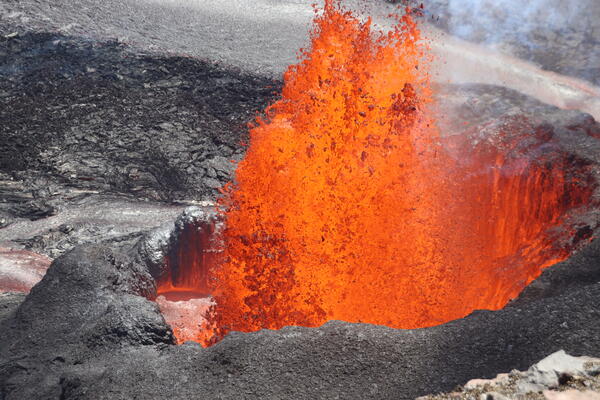
March 14, 2025—View of Kīlauea December 1974 fissures and lava flows

An aerial view of the December 31, 1974 fissures and lava flows taken during an overflight of Kīlauea summit and upper Southwest Rift Zone on March 14, 2025. The 1974 eruption lasted 6 hours and occurred in Kīlauea's upper Southwest Rift Zone.

An aerial view of the December 31, 1974 fissures and lava flows taken during an overflight of Kīlauea summit and upper Southwest Rift Zone on March 14, 2025. The 1974 eruption lasted 6 hours and occurred in Kīlauea's upper Southwest Rift Zone.

Wide aerial view of Kīlauea summit caldera
March 14, 2025—Kīlauea summit eruption overflight

Hawaiian Volcano Observatory geologists captured this aerial view of Kīlauea summit on March 14, 2025, during a helicopter overflight. Three days after the end of episode 13 of the ongoing eruption, the north and south cones are degassing in the southwest corner of Halema‘uma‘u.

Hawaiian Volcano Observatory geologists captured this aerial view of Kīlauea summit on March 14, 2025, during a helicopter overflight. Three days after the end of episode 13 of the ongoing eruption, the north and south cones are degassing in the southwest corner of Halema‘uma‘u.

Close up aerial view of the north vent cone degassing in the southwest corner of Halema‘uma‘u
March 14, 2025 — Kīlauea eruption remains on pause during summit overflight

On the morning of March 14, USGS Hawaiian Volcano Observatory scientists conducted an overflight of Kīlauea summit to capture thermal and surficial imagery of the ongoing (paused) eruption. Three days after the end of episode 13, this telephoto aerial view shows the north cone degassing in the southwest corner of Halema‘uma‘u.

On the morning of March 14, USGS Hawaiian Volcano Observatory scientists conducted an overflight of Kīlauea summit to capture thermal and surficial imagery of the ongoing (paused) eruption. Three days after the end of episode 13, this telephoto aerial view shows the north cone degassing in the southwest corner of Halema‘uma‘u.

A scientist works on servicing volcano monitoring equipment with steaming volcanic vents in background
HVO geologist services webcam day after episode 13 at Kīlauea

On March 12, a USGS Hawaiian Volcano Observatory geologist on the southwest rim of Kaluapele (Kīlauea summit caldera) serviced the S2cam webcam. A plume of water vapor and volcanic gas rises from the two vents of the ongoing eruption within Halema‘uma‘u crater, one day after the 13th episode of the eruption. USGS photo by N. Deligne.

On March 12, a USGS Hawaiian Volcano Observatory geologist on the southwest rim of Kaluapele (Kīlauea summit caldera) serviced the S2cam webcam. A plume of water vapor and volcanic gas rises from the two vents of the ongoing eruption within Halema‘uma‘u crater, one day after the 13th episode of the eruption. USGS photo by N. Deligne.

A shovel is stuck into a thick deposit of gray/brown volcanic tephra
Crater Rim Drive tephra blanket

The section of Crater Rim Drive downwind of the recent fountaining, and in an area closed to the public due to volcanic hazards, has been covered by numerous layers of tephra in the past several months. The tire tracks are centered over the Crater Rim Drive roadway, where USGS scientists access critical volcano monitoring sites.

The section of Crater Rim Drive downwind of the recent fountaining, and in an area closed to the public due to volcanic hazards, has been covered by numerous layers of tephra in the past several months. The tire tracks are centered over the Crater Rim Drive roadway, where USGS scientists access critical volcano monitoring sites.

Molten lava fountain erupting from a vent of dark cooled lava
Episode 13 fountaining at Kīlauea summit

On the morning of March 11, the north vent was producing lava fountains about 50 meters (160 feet) high, with fountaining emerging from a small, sloshing pond held within the walls of the north vent cone. The pond can be seen in the lower left portion of the photo, as well as the lava spillway which exits through a notch in the cone that is obscured in this view.

On the morning of March 11, the north vent was producing lava fountains about 50 meters (160 feet) high, with fountaining emerging from a small, sloshing pond held within the walls of the north vent cone. The pond can be seen in the lower left portion of the photo, as well as the lava spillway which exits through a notch in the cone that is obscured in this view.

A scientist walks on a blanket of gray tephra with tire tracks over the buried pavement
Kīlauea summit tephra blanket from episodic fountaining

An HVO geologist returns from a tephra collection bucket at the summit of Kīlauea, carrying a new sample. The outgassing plume from the vents is carried over the roadway, now covered by over 50 cm (20 inches) of tephra in places. All samples are collected in coordination with, and after receiving permission from, Hawai‘i Volcanoes National Park. USGS photo by M.

An HVO geologist returns from a tephra collection bucket at the summit of Kīlauea, carrying a new sample. The outgassing plume from the vents is carried over the roadway, now covered by over 50 cm (20 inches) of tephra in places. All samples are collected in coordination with, and after receiving permission from, Hawai‘i Volcanoes National Park. USGS photo by M.

Scientist looks through a laser rangefinder at steaming vents within a crater to make measurements
Field visit following episode 13 fountaining

A USGS Hawaiian Volcano Observatory geologist uses a handheld laser rangefinder on the southwest rim of Kaluapele (Kīlauea summit caldera) to measure the height of the recently active cones within Halema‘uma‘u. USGS photo taken on March 12, 2025, by M. Patrick.

A USGS Hawaiian Volcano Observatory geologist uses a handheld laser rangefinder on the southwest rim of Kaluapele (Kīlauea summit caldera) to measure the height of the recently active cones within Halema‘uma‘u. USGS photo taken on March 12, 2025, by M. Patrick.

Zoomed in view of two inactive lava vents with white volcanic gas plumes being emitted
Kīlauea south vent cone within Halema‘uma‘u

A closeup view of the south cone at the summit of Kīlauea, showing the semi-molten nature of the cone flanks. During fountaining, lava accumulates on the cone's flanks at such a high rate that the material remains hot and semi-molten, despite the appearance of cooled, solid material on the surface.

A closeup view of the south cone at the summit of Kīlauea, showing the semi-molten nature of the cone flanks. During fountaining, lava accumulates on the cone's flanks at such a high rate that the material remains hot and semi-molten, despite the appearance of cooled, solid material on the surface.

An orange broken bucket is partially buried by a thick blanket of gray/brown tephra
Tephra blanket from Kīlauea summit fountaining episodes

An orange five-gallon plastic bucket, secured by heavy weights, was one of several used to collect tephra from the ongoing lava fountaining at the summit of Kīlauea. The episode 13 fountaining, however, cast large bombs (some of them molten) in this particular area, battering the ground.

An orange five-gallon plastic bucket, secured by heavy weights, was one of several used to collect tephra from the ongoing lava fountaining at the summit of Kīlauea. The episode 13 fountaining, however, cast large bombs (some of them molten) in this particular area, battering the ground.

Lava fountains erupt from side-by-side vents within a crater
Episode 13 fountaining at Kīlauea summit

On March 11, HVO geologists observed episode 13 of the ongoing Kīlauea summit eruption from the western caldera rim. Lava fountains from the north vent (left) and south vent (right) were feeding channelized flows across the floor of Halema‘uma‘u crater. USGS photo by M. Patrick.

On March 11, HVO geologists observed episode 13 of the ongoing Kīlauea summit eruption from the western caldera rim. Lava fountains from the north vent (left) and south vent (right) were feeding channelized flows across the floor of Halema‘uma‘u crater. USGS photo by M. Patrick.

Orange lava fountains erupting from a crater wall
Episode 13 fountaining at Kīlauea summit

Episode 13 fountaining began early on March 11 and continued through an HVO helicopter overflight of the Kīlauea summit region around 10:00 a.m. Visibility was slightly hampered by passing showers.

Episode 13 fountaining began early on March 11 and continued through an HVO helicopter overflight of the Kīlauea summit region around 10:00 a.m. Visibility was slightly hampered by passing showers.

Geologist approaching an active lava flow
Episode 13 fountaining at Kīlauea summit

During a March 11 Hawaiian Volcano Observatory eruption monitoring flight at Kīlauea summit, scientists landed to make observations and collect samples. At the front of the channelized flow from the episode 13 north vent fountain in Halema‘uma‘u crater, a USGS geologist walks the flow margin to find a safe spot to collect a molten lava sample.

During a March 11 Hawaiian Volcano Observatory eruption monitoring flight at Kīlauea summit, scientists landed to make observations and collect samples. At the front of the channelized flow from the episode 13 north vent fountain in Halema‘uma‘u crater, a USGS geologist walks the flow margin to find a safe spot to collect a molten lava sample.

Color photograph of lava fountaining
March 11, 2025 — Episode 13 of lava fountaining at Kīlauea summit

In this image captured on USGS Hawaiian Volcano Observatory research camera S2cam, fountains erupt with similar heights from the north and south vents during episode 13 on March 11, 2025. The maximum fountain height during this episode was 215 meters (700 feet), measured at the north vent. USGS photo. 

In this image captured on USGS Hawaiian Volcano Observatory research camera S2cam, fountains erupt with similar heights from the north and south vents during episode 13 on March 11, 2025. The maximum fountain height during this episode was 215 meters (700 feet), measured at the north vent. USGS photo. 

Lava flow with silver crust and hot molten lava visible underneath
Episode 13 fountaining at Kīlauea summit

On the Halema‘uma‘u crater floor, the front of a fast-moving channelized lava flow from the north vent fountain was composed of slabby pāhoehoe. USGS photo taken on March 11, 2025, by M. Patrick.

On the Halema‘uma‘u crater floor, the front of a fast-moving channelized lava flow from the north vent fountain was composed of slabby pāhoehoe. USGS photo taken on March 11, 2025, by M. Patrick.

Close up view of lava fountain building up a cone around it
Episode 13 fountaining at Kīlauea summit

A telephoto view of the northern vent fountain within Halema‘uma‘u crater. The steep septum separating the north and south fountains was under constant barrage today by molten lava falling from the fountains, with the steep walls on the inside of the cones in a state of constant dripping and flowing back into crater. USGS photo by M.

A telephoto view of the northern vent fountain within Halema‘uma‘u crater. The steep septum separating the north and south fountains was under constant barrage today by molten lava falling from the fountains, with the steep walls on the inside of the cones in a state of constant dripping and flowing back into crater. USGS photo by M.

Close up photo of a scientist collecting eruption data
Episode 13 fountaining at Kīlauea summit

A USGS geologist uses a handheld laser rangefinder to measure eruption features during the 13th episode of the Kīlauea summit eruption. USGS photo taken on March 11 from the western rim of Halema‘uma‘u by M. Patrick.

A USGS geologist uses a handheld laser rangefinder to measure eruption features during the 13th episode of the Kīlauea summit eruption. USGS photo taken on March 11 from the western rim of Halema‘uma‘u by M. Patrick.

A USGS vehicle is seen on top of a road covered by volcanic tephra
Episode 13 fountaining at Kīlauea summit

The closed portion of Crater Rim Drive, just west of the active vents, has been covered by a deep layer of tephra falling out downwind from the recent lava fountains. In this section, the deposit is only a few inches thick, but farther down the road the tephra has accumulated into drifts that are up to about a half meter (or half a yard) thick.

The closed portion of Crater Rim Drive, just west of the active vents, has been covered by a deep layer of tephra falling out downwind from the recent lava fountains. In this section, the deposit is only a few inches thick, but farther down the road the tephra has accumulated into drifts that are up to about a half meter (or half a yard) thick.

Color photograph of lava fountain
March 11, 2025—North vent lava fountain

The north vent in Halema‘uma‘u crater was producing lava fountains about 160 feet (50 meters) high on the morning of March 11, with these fountains emerging from a small, sloshing pond inside the walls of the vent's spatter cone.

The north vent in Halema‘uma‘u crater was producing lava fountains about 160 feet (50 meters) high on the morning of March 11, with these fountains emerging from a small, sloshing pond inside the walls of the vent's spatter cone.

Color photograph of lava within vent
March 10, 2025—Low level spattering between eruptive episodes at Kīlauea volcano

On March 10, 2025, field teams saw low-level spattering from a small opening within north cone, active during recent eruptive episodes of the ongoing eruption at Halema‘uma‘u, Kīlauea volcano. This indicates that magma is very close to the surface. This photo was taken at 1:32 p.m. H.S.T., looking down nearly 600 feet (183 meters) above the crater floor.

On March 10, 2025, field teams saw low-level spattering from a small opening within north cone, active during recent eruptive episodes of the ongoing eruption at Halema‘uma‘u, Kīlauea volcano. This indicates that magma is very close to the surface. This photo was taken at 1:32 p.m. H.S.T., looking down nearly 600 feet (183 meters) above the crater floor.

Color map showing eruption extent
March 10, 2025—Kīlauea summit eruption reference map

This reference map depicts the Kīlauea summit eruption within Halema‘uma‘u crater that began on December 23, 2024. As of this posting on March 10, the eruption has had twelve episodes, with a thirteenth likely to occur the next 24 hours.

This reference map depicts the Kīlauea summit eruption within Halema‘uma‘u crater that began on December 23, 2024. As of this posting on March 10, the eruption has had twelve episodes, with a thirteenth likely to occur the next 24 hours.

Was this page helpful?