
The closed portion of Crater Rim Drive, just west of the active vents, has been covered by a deep layer of tephra falling out downwind from the recent lava fountains. In this section, the deposit is only a few inches thick, but farther down the road the tephra has accumulated into drifts that are up to about a half meter (or half a yard) thick.
Images
Kīlauea images of eruptive activity, field work, and more.
Filter Total Items: 3024

Episode 13 fountaining at Kīlauea summit
The closed portion of Crater Rim Drive, just west of the active vents, has been covered by a deep layer of tephra falling out downwind from the recent lava fountains. In this section, the deposit is only a few inches thick, but farther down the road the tephra has accumulated into drifts that are up to about a half meter (or half a yard) thick.
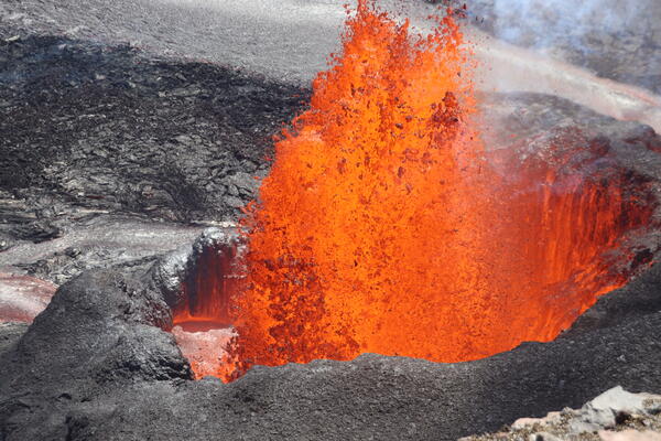
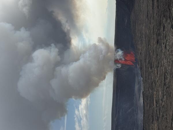
March 11, 2025—North vent lava fountain
The north vent in Halema‘uma‘u crater was producing lava fountains about 160 feet (50 meters) high on the morning of March 11, with these fountains emerging from a small, sloshing pond inside the walls of the vent's spatter cone.
The north vent in Halema‘uma‘u crater was producing lava fountains about 160 feet (50 meters) high on the morning of March 11, with these fountains emerging from a small, sloshing pond inside the walls of the vent's spatter cone.
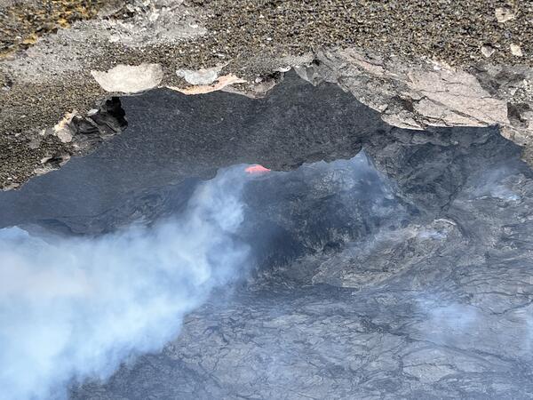
March 10, 2025—Low level spattering between eruptive episodes at Kīlauea volcano
March 10, 2025—Low level spattering between eruptive episodes at Kīlauea volcanoOn March 10, 2025, field teams saw low-level spattering from a small opening within north cone, active during recent eruptive episodes of the ongoing eruption at Halema‘uma‘u, Kīlauea volcano. This indicates that magma is very close to the surface. This photo was taken at 1:32 p.m. H.S.T., looking down nearly 600 feet (183 meters) above the crater floor.

March 10, 2025—Kīlauea summit eruption reference map
March 10, 2025—Kīlauea summit eruption reference mapThis reference map depicts the Kīlauea summit eruption within Halema‘uma‘u crater that began on December 23, 2024. As of this posting on March 10, the eruption has had twelve episodes, with a thirteenth likely to occur the next 24 hours.

March 6, 2025 — Damage from a lava bomb ejected during episode 12 lava fountaining
March 6, 2025 — Damage from a lava bomb ejected during episode 12 lava fountainingUSGS Hawaiian Volcano Observatory (HVO) collects tephra from lava fountaining in buckets. Each bucket has a weight inside to prevent high winds from blowing the bucket away; some of these weights are milk jugs filled with sand.

March 6, 2025 — Gas plume a day after the end of episode 12 at Kīlauea's summit
March 6, 2025 — Gas plume a day after the end of episode 12 at Kīlauea's summitA day after the end of episode 12 of the ongoing eruption at Kīlauea's summit, volcanic gas emissions continue from the recently active north and south cones on the western edge of Halema‘uma‘u. Most of the gas consists of water vapor (the primary volcanic gas), with sulfur dioxide (SO2) and other gases.

March 6, 2025 — Remnant of cone from June 2023 eruption surrounded by lava of current Kīlauea eruption
March 6, 2025 — Remnant of cone from June 2023 eruption surrounded by lava of current Kīlauea eruptionLava flows from the eruption which started on December 23, 2024, within Halema‘uma‘u at the summit of Kīlauea volcano, have buried most of the cone from the June 2023 eruption, seen here in the upper middle of photo. This telephoto was taken north of the degassing north and south cones, and is looking toward to the south through the volcanic gas plume.

March 5, 2025 — Kīlauea lava flows
With permission from Hawaiʻi Volcanoes National Park, USGS-Hawaiian Volcano Observatory staff geologists conducted a monitoring overflight of Kīlauea summit eruption area at approximately 10 a.m. HST on March 5, 2025. During the flight, the team landed briefly on the floor of Halemaʻumaʻu to collect a molten sample of lava.
With permission from Hawaiʻi Volcanoes National Park, USGS-Hawaiian Volcano Observatory staff geologists conducted a monitoring overflight of Kīlauea summit eruption area at approximately 10 a.m. HST on March 5, 2025. During the flight, the team landed briefly on the floor of Halemaʻumaʻu to collect a molten sample of lava.
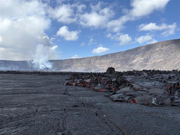
March 5, 2025 — Views from the floor of Halemaʻumaʻu, Kīlauea volcano
March 5, 2025 — Views from the floor of Halemaʻumaʻu, Kīlauea volcanoA view across of the new lava flows on the floor of Halemaʻumaʻu, looking towards the active north and south vents on the west wall of the crater. USGS photo by D. Downs on March 5, 2025.
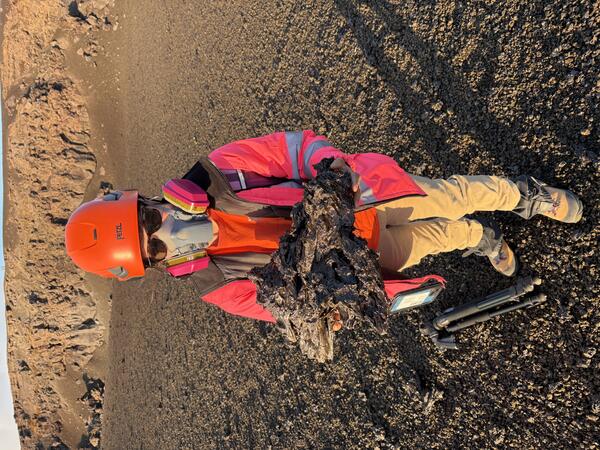
March 5, 2025 — Tephra clast erupting during episode 12 of Kīlauea summit eruption
March 5, 2025 — Tephra clast erupting during episode 12 of Kīlauea summit eruptionDuring the lava fountains of episode 12, which reached approximately 300 feet (90 meters) high, tephra particles traveled through the air to be deposited on the crater rim down wind. This clast was about 16 inches (40 centimeters) long. The tephra clasts formed during the recent lava fountains are very bubble rich and delicate, breaking easily when they are moved.

March 4, 2025 — Lava textures at Kīlauea
A telephoto image of episode 12's lava fountains show the varied textures of motel material as it leaves the vent. In the fountain you can see the formation of both cinder and spatter. Cinders are glassy, vesicular, pyroclastic fragments that fall to the ground in an essentially solid condition. These are the smaller, darker particles in the figure.
A telephoto image of episode 12's lava fountains show the varied textures of motel material as it leaves the vent. In the fountain you can see the formation of both cinder and spatter. Cinders are glassy, vesicular, pyroclastic fragments that fall to the ground in an essentially solid condition. These are the smaller, darker particles in the figure.
March 4, 2025 — Kīlauea episode 12 eruption and plume
March 4, 2025 — Kīlauea episode 12 eruption and plumeThis view of episode 12 of the Kīlauea summit eruption in Halemaʻumaʻu was taken the evening of March 4, 2025, from the Kaluapele overlook near Kīlauea Military Camp in Hawaiʻi Volcanoes National Park. USGS photo by K. Mulliken.
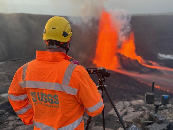
March 4, 2025 — USGS scientist monitors Kīlauea eruption
March 4, 2025 — USGS scientist monitors Kīlauea eruptionA USGS Hawaiian Volcano Observatory scientist monitors episode 12 of the ongoing Kīlauea eruption during the evening of March 4, 2025. While working in the hazardous closed area of Hawaiʻi Volcanoes National Park, USGS staff wear personal protective equipment, including high-visibility clothing, hard helmets, gas masks, gloves, and eye protection. USGS photo by M.

March 4, 2025 — Lava flows in Halema‘uma‘u, Kīlauea volcano
March 4, 2025 — Lava flows in Halema‘uma‘u, Kīlauea volcanoDuring a USGS Hawaiian Volcano Observatory Kīlauea eruption monitoring overflight on March 4, 2025, geology field crews sampled a viscous molten lava flow on the eastern margin of the lake. This flow is likely an ooze out from the molten lake interior, and represents lava erupted in previous episodes.

March 4, 2025 — Minor activity at the summit of Kīlauea
March 4, 2025 — Minor activity at the summit of KīlaueaCoincident with a scheduled USGS Hawaiian Volcano Observatory eruption monitoring overflight the morning of Tuesday, March 4, 2025, Kīlauea's ongoing eruption in Halema‘uma‘u started to show minor activity at both eruptive vents. This aerial view of the vents taken at 8:04 a.m.

March 4, 2025 — Kaluapele panorama
A panoramic view of Kaluapele, the caldera at the summit of Kīlauea volcano, taken from the Volcano House Hotel overlook in Hawaiʻi Volcanoes National Park. The intermittently active vents on the west wall of the caldera are visibly degassing in the shadowed background of the image, while Mauna Loa is illuminated in the sunlight.
A panoramic view of Kaluapele, the caldera at the summit of Kīlauea volcano, taken from the Volcano House Hotel overlook in Hawaiʻi Volcanoes National Park. The intermittently active vents on the west wall of the caldera are visibly degassing in the shadowed background of the image, while Mauna Loa is illuminated in the sunlight.

March 4, 2025 — Kīlauea summit monitoring overflight
March 4, 2025 — Kīlauea summit monitoring overflightOnly weak vent activity was observed on the USGS Hawaiian Volcano Observatory monitoring helicopter overflight of Kīlauea summit at 8 a.m. HST on March 4, 2025. Weak effusive activity continued throughout the day until around 2 p.m., when fountaining started with more vigor, producing a larger flow across the crater floor. USGS photo by M. Patrick.

March 4, 2025 — Kīlauea summit eruption sample
A USGS Hawaiian Volcano Observatory geologist collected of molten sample of lava in the eastern portion of Halema‘uma‘u crater the morning of March 4, 2025. In this portion of the crater, far from the eruptive vents, lava has slowly oozed out in recent days as residue from earlier episodes.
A USGS Hawaiian Volcano Observatory geologist collected of molten sample of lava in the eastern portion of Halema‘uma‘u crater the morning of March 4, 2025. In this portion of the crater, far from the eruptive vents, lava has slowly oozed out in recent days as residue from earlier episodes.
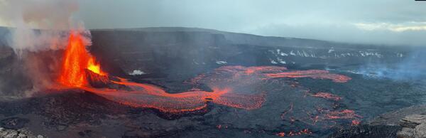
March 4, 2025 — Overview of episode 12 of Kīlauea summit eruption
March 4, 2025 — Overview of episode 12 of Kīlauea summit eruptionDuring the early evening of March 4, 2025, USGS scientists captured this view of both the north and south vent erupting lava fountains during episode 12 of the ongoing Kīlauea summit eruption. During this episode, lava fountains reached up to 250-300 feet (80-90 meters) in height. USGS photo by M. Patrick.

March 4, 2025 — Episode 12 at the summit of Kīlauea
March 4, 2025 — Episode 12 at the summit of KīlaueaEpisode 12 of the ongoing Halemaʻumaʻu eruption began a fountaining phase at 2 p.m. HST on March 4. Several small lava flows came from the south vent during the morning and early afternoon of March 4. At 2:00 p.m. HST, fountaining began at the north vent.

March 4, 2025 — Kīlauea eruption episode 12
Both the north and south vents have been active in the ongoing episode 12 of the Kīlauea summit eruption in Halemaʻumaʻu. Lava fountains feed lava flows that cover part of the floor of Halemaʻumaʻu. USGS photo by L. Gallant.
Both the north and south vents have been active in the ongoing episode 12 of the Kīlauea summit eruption in Halemaʻumaʻu. Lava fountains feed lava flows that cover part of the floor of Halemaʻumaʻu. USGS photo by L. Gallant.