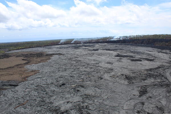
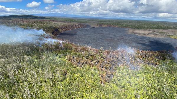
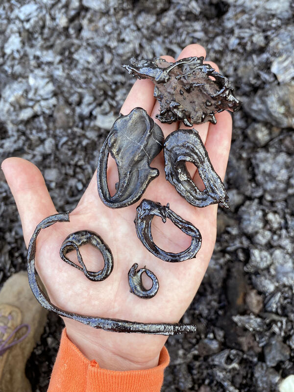
U.S. flag

An official website of the United States government

Images

Kīlauea images of eruptive activity, field work, and more.

Filter Total Items: 2923
Color photograph of field engineer adjusting volcano-monitoring instrument
July 2, 2024 — Leveling the UWE tiltmeter at the summit of Kīlauea

On July 2, 2024, HVO field engineers re-leveled the UWE tiltmeter located near Uēkahuna bluff in Hawaiʻi Volcanoes National Park. The instrument has recently approached the edge of its scale range, having recorded over 300 microradians of deformation since it was last re-leveled in August 2018.

On July 2, 2024, HVO field engineers re-leveled the UWE tiltmeter located near Uēkahuna bluff in Hawaiʻi Volcanoes National Park. The instrument has recently approached the edge of its scale range, having recorded over 300 microradians of deformation since it was last re-leveled in August 2018.

Color photograph of field engineer vacuuming sand from a borehole
July 2, 2024 — Leveling the UWE tiltmeter at the summit of Kīlauea

Before the UWE tiltmeter could be leveled, sand had to removed from the six-meter-deep (20 feet) borehole housing the tiltmeter. HVO field engineers use a high-power vacuum to remove the sand, in order to access the tiltmeter. USGS image by M. Warren.

Before the UWE tiltmeter could be leveled, sand had to removed from the six-meter-deep (20 feet) borehole housing the tiltmeter. HVO field engineers use a high-power vacuum to remove the sand, in order to access the tiltmeter. USGS image by M. Warren.

View down a borehole hosting a volcano-monitoring instrument
July 2, 2024 — Leveling the UWE tiltmeter at the summit of Kīlauea

A view down the borehole that houses the UWE tiltmeter. The UWE tiltmeter was installed in 1999 and it is an important instrument within HVO's Kīlauea monitoring network, providing data on the pressurization levels within the shallow magma storage body beneath Halema‘uma‘u. USGS image by M. Warren. 

A view down the borehole that houses the UWE tiltmeter. The UWE tiltmeter was installed in 1999 and it is an important instrument within HVO's Kīlauea monitoring network, providing data on the pressurization levels within the shallow magma storage body beneath Halema‘uma‘u. USGS image by M. Warren. 

Color photograph of a volcanic crater
Puhimau Crater on Kīlauea

View of Puhimau Crater, one of the many craters visible just off of Chain of Craters Road within Hawaiʻi Volcanoes National Park. USGS photo by K. Mulliken. 

View of Puhimau Crater, one of the many craters visible just off of Chain of Craters Road within Hawaiʻi Volcanoes National Park. USGS photo by K. Mulliken. 

Color photograph of a sign marking where lava flows crossed a road
May 1973 lava flows on Kīlauea’s upper East Rift Zone

Location where the May 1973 lava flows on Kīlauea’s upper East Rift Zone cross Chain of Craters Road in Hawaiʻi Volcanoes National Park. USGS image by K. Mulliken. 

Location where the May 1973 lava flows on Kīlauea’s upper East Rift Zone cross Chain of Craters Road in Hawaiʻi Volcanoes National Park. USGS image by K. Mulliken. 

Color map showing distribution of volcanic features
Kīlauea upper East Rift Zone reference map

This reference map depicts the features on Kīlauea's upper East Rift Zone. Chain of Craters Road in Hawaiʻi Volcanoes National Park follows the path of the upper East Rift Zone. Pit craters, thermal areas, and lava flows are evidence of a long history of magma moving along this rift zone pathway.

This reference map depicts the features on Kīlauea's upper East Rift Zone. Chain of Craters Road in Hawaiʻi Volcanoes National Park follows the path of the upper East Rift Zone. Pit craters, thermal areas, and lava flows are evidence of a long history of magma moving along this rift zone pathway.

Color graphic showing ground deformation at summit of volcano
June 29, 2024—InSAR image of Kīlauea ground deformation

This map shows recent deformation at Kīlauea, over the timeframe of June 13 to June 29, 2024. Data was recorded by the Italian Space Agency's (ASI) Cosmo-SkyMED satellite. Colored fringes denote areas of ground deformation, with more fringes indicating more deformation.  Each color cycle represents 1.5 cm (0.6 in) of ground motion.

This map shows recent deformation at Kīlauea, over the timeframe of June 13 to June 29, 2024. Data was recorded by the Italian Space Agency's (ASI) Cosmo-SkyMED satellite. Colored fringes denote areas of ground deformation, with more fringes indicating more deformation.  Each color cycle represents 1.5 cm (0.6 in) of ground motion.

Color photograph of field engineer hiking through forest
June 25, 2024 — Webcam upgrade for Kīlauea summit and Southwest Rift Zone

HVO physical science technicians maintain dozens of HVO field stations across the Island of Hawai‘i, providing an opportunity to work in remote wilderness areas. Here, an HVO physical science technician carries out the old webcam along the Mauna Loa trail on a beautiful day. USGS photo by M. Patrick.

HVO physical science technicians maintain dozens of HVO field stations across the Island of Hawai‘i, providing an opportunity to work in remote wilderness areas. Here, an HVO physical science technician carries out the old webcam along the Mauna Loa trail on a beautiful day. USGS photo by M. Patrick.

Color photograph of scientist checking computer in the field
June 25, 2024 — Webcam upgrade for Kīlauea summit and Southwest Rift Zone

An HVO geologist tests the upgraded KPcam connection to see if newly acquired images are being transmitted to the observatory. During the most recent Kīlauea eruption on June 3, the KPcam captured the glow as lava began erupting on the surface of the Southwest Rift Zone. USGS photo by M. Warren.

An HVO geologist tests the upgraded KPcam connection to see if newly acquired images are being transmitted to the observatory. During the most recent Kīlauea eruption on June 3, the KPcam captured the glow as lava began erupting on the surface of the Southwest Rift Zone. USGS photo by M. Warren.

Color photograph of field engineer adjusting volcano monitoring equipment
June 25, 2024 — Webcam upgrade for Kīlauea summit and Southwest Rift Zone

An HVO field engineer adjusts the view of the upgraded KPcam, which is fixed on a mast a couple meters (yards) above the ground surface. The camera is located on the south flank of Mauna Loa, at an elevation of about 2,000 meters (6,700 feet) above sea level, and provides expansive views to the southeast of Kīlauea. USGS photo by M. Warren.

An HVO field engineer adjusts the view of the upgraded KPcam, which is fixed on a mast a couple meters (yards) above the ground surface. The camera is located on the south flank of Mauna Loa, at an elevation of about 2,000 meters (6,700 feet) above sea level, and provides expansive views to the southeast of Kīlauea. USGS photo by M. Warren.

Color photograph of scientist installing webcam on mast
June 25, 2024 — Webcam upgrade for Kīlauea summit and Southwest Rift Zone

An HVO geologist attaches the upgraded KPcam to the mast. Like all HVO webcams, the KPcam is in box that protects it against the weather and elements. USGS photo by M. Warren.

Color photograph of field engineers installing webcam
June 25, 2024 — Webcam upgrade for Kīlauea summit and Southwest Rift Zone

The KPcam, a webcam on the flank of Mauna Loa that looks south towards Kīlauea summit and the Southwest Rift Zone, was upgraded on June 25 by HVO staff. The new webcam will provide a higher quality image and slightly wider field of view. This photo shows HVO physical science technicians removing the old webcam. USGS photo by M. Patrick.

The KPcam, a webcam on the flank of Mauna Loa that looks south towards Kīlauea summit and the Southwest Rift Zone, was upgraded on June 25 by HVO staff. The new webcam will provide a higher quality image and slightly wider field of view. This photo shows HVO physical science technicians removing the old webcam. USGS photo by M. Patrick.

Color photograph of field engineer servicing a webcam station
June 25, 2024 — Webcam upgrade for Kīlauea summit and Southwest Rift Zone

An HVO physical science technician checks the wiring on the new webcam, attached to the top of the mast, that looks towards the summit and Southwest Rift Zone of Kīlauea. USGS photo by M. Patrick.

Color photograph of a mast with an antenna and webcam fixed to it
June 25, 2024 — Webcam upgrade for Kīlauea summit and Southwest Rift Zone

The upgraded KPcam is located in the white box, fixed on a mast about a couple meters (yards) high. The camera view, which is the southeast, captures the uppermost portions of Kīlauea's middle East Rift Zone, the summit region, and the upper part of Kīlauea's Southwest Rift Zone.

The upgraded KPcam is located in the white box, fixed on a mast about a couple meters (yards) high. The camera view, which is the southeast, captures the uppermost portions of Kīlauea's middle East Rift Zone, the summit region, and the upper part of Kīlauea's Southwest Rift Zone.

Color photograph of volcano monitoring station
June 25, 2024 — Webcam upgrade for Kīlauea summit and Southwest Rift Zone

Energy from solar panels at the KPcam site is stored in large batteries, which power the camera. Images captured by the camera are relayed, via an antenna, back to the observatory. USGS image by M. Warren.

Energy from solar panels at the KPcam site is stored in large batteries, which power the camera. Images captured by the camera are relayed, via an antenna, back to the observatory. USGS image by M. Warren.

Color image showing deformation at summit of volcano
June 13, 2024—InSAR image of deformation following Kīlauea Southwest Rift Zone eruption

This map shows deformation following the recent eruption at Kīlauea on June 3, 2024.  It covers from June 6 to June 13, 2024, and is recorded by the Italian Space Agency's (ASI) Cosmo-SkyMED satellite. Colored fringes denote areas of ground deformation, with more fringes indicating more deformation.  Each color cycle represents 1.5 cm (0.6 in) of

This map shows deformation following the recent eruption at Kīlauea on June 3, 2024.  It covers from June 6 to June 13, 2024, and is recorded by the Italian Space Agency's (ASI) Cosmo-SkyMED satellite. Colored fringes denote areas of ground deformation, with more fringes indicating more deformation.  Each color cycle represents 1.5 cm (0.6 in) of

Color map showing ground deformation on volcano
June 6, 2024—InSAR image of deformation during Kīlauea Southwest Rift Zone eruption

This map shows recent deformation spanning the recent eruption at Kīlauea.  It covers from May 28 to June 6, 2024, and is recorded by the Italian Space Agency's (ASI) Cosmo-SkyMED satellite. Colored fringes denote areas of ground deformation, with more fringes indicating more deformation.  Each color cycle represents 1.5 cm (0.6 in) of ground mot

This map shows recent deformation spanning the recent eruption at Kīlauea.  It covers from May 28 to June 6, 2024, and is recorded by the Italian Space Agency's (ASI) Cosmo-SkyMED satellite. Colored fringes denote areas of ground deformation, with more fringes indicating more deformation.  Each color cycle represents 1.5 cm (0.6 in) of ground mot

Color photograph of lava flow and volcanic gas
June 6, 2024 — Aerial overview of inactive Fissures 3 and 4 on the Southwest Rift Zone of Kīlauea

Aerial overview of fissures 3 and 4 of the now paused Kīlauea Southwest Rift Zone eruption that began on June 3, 2024. During an overflight at approximately 8:15 a.m. HST on June 6, 2024, USGS Hawaiian Volcano Observatory scientists observed persistent gas emissions and no active lava. USGS Image by A.R. Nalesnik.

Aerial overview of fissures 3 and 4 of the now paused Kīlauea Southwest Rift Zone eruption that began on June 3, 2024. During an overflight at approximately 8:15 a.m. HST on June 6, 2024, USGS Hawaiian Volcano Observatory scientists observed persistent gas emissions and no active lava. USGS Image by A.R. Nalesnik.

Color photograph of field engineers installing new instrumentation
June 6, 2024 — Installing a new seismometer on Kīlauea Southwest Rift Zone

On June 6, USGS Hawaiian Volcano Observatory field engineers installed a new seismometer on the Southwest Rift Zone of Kīlauea to monitor earthquakes. The new seismic station is co-located at an existing monitoring station consisting of a GPS and high-resolution gas monitoring equipment.

On June 6, USGS Hawaiian Volcano Observatory field engineers installed a new seismometer on the Southwest Rift Zone of Kīlauea to monitor earthquakes. The new seismic station is co-located at an existing monitoring station consisting of a GPS and high-resolution gas monitoring equipment.

Color photograph of seismometer buried in the ground
June 6, 2024 — New seismometer at station KOSM on the Southwest Rift Zone of Kīlauea

The new seismometer at station KOSM on the Southwest Rift Zone of Kīlauea being buried in the ground, with permission from Hawai'i Volcanoes National Park. This photo was taken before the seismometer was totally buried.

Color map of recent lava flows
June 6, 2024 — Kīlauea Southwest Rift Zone eruption

This reference map depicts the June 3, 2024, eruption along Kīlauea's Southwest Rift Zone. The lava flows are shown in pink, covering about 99 acres (40 hectares); this number represents a slight increase from that reported Monday, June 3, due to minor flow expansion in the hours following that morning's helicopter overflight.

This reference map depicts the June 3, 2024, eruption along Kīlauea's Southwest Rift Zone. The lava flows are shown in pink, covering about 99 acres (40 hectares); this number represents a slight increase from that reported Monday, June 3, due to minor flow expansion in the hours following that morning's helicopter overflight.

Was this page helpful?