
A wide view of the lava lake in Halema‘uma‘u taken during a helicopter overflight on the morning of November 9, 2021. Lava is once again visible in the spillway of the west vent after a brief drop in activity on Monday, November 8.
Images
Kīlauea images of eruptive activity, field work, and more.
Filter Total Items: 3089

A view of the plume rising above Halema‘uma‘u
A wide view of the lava lake in Halema‘uma‘u taken during a helicopter overflight on the morning of November 9, 2021. Lava is once again visible in the spillway of the west vent after a brief drop in activity on Monday, November 8.

November 9, 2021—Kīlauea summit thermal map
A helicopter overflight on November 9, 2021, at approximately 8:30 a.m. HST allowed for aerial visual and thermal imagery to be collected of Halema‘uma‘u crater at the summit of Kīlauea. The scale of the thermal map ranges from blue to red, with blue colors indicative of cooler temperatures and red colors indicative of warmer temperatures.
A helicopter overflight on November 9, 2021, at approximately 8:30 a.m. HST allowed for aerial visual and thermal imagery to be collected of Halema‘uma‘u crater at the summit of Kīlauea. The scale of the thermal map ranges from blue to red, with blue colors indicative of cooler temperatures and red colors indicative of warmer temperatures.

Eruption in Halema‘uma‘u, Kīlauea summit - Nov 8, 2021
Eruption in Halema‘uma‘u, Kīlauea summit - Nov 8, 2021Despite the temporary decrease in activity at Halema‘uma‘u crater, at the summit of Kīlauea, spattering was still visible within the west vent cone. This telephoto image was taken from the western rim of the crater during a lower level of eruptive activity on November 8, 2021. USGS photo by J.M. Chang.

Eruption in Halema‘uma‘u, Kīlauea summit - Nov 8, 2021
Eruption in Halema‘uma‘u, Kīlauea summit - Nov 8, 2021The extent of the active lava lake surface (lower right) within Halema‘uma‘u crater, at the summit of Kīlauea, had decreased substantially over the previous day and (at the time of this photo) was limited to the area around the west vent. This photo was taken at 5:48 p.m. HST on November 8, 2021, from the western rim of the crater. USGS photo by J.M. Chang.

November 4, 2021—Kīlauea summit eruption reference map
November 4, 2021—Kīlauea summit eruption reference mapThis reference map depicts the ongoing Kīlauea summit eruption on November 4, 2021. One eruptive vent is active within Halema‘uma‘u at this time, along the western edge of the rising lava lake.

Eruption within Halema‘uma‘u crater, Kīlauea summit - November 3, 2021
Eruption within Halema‘uma‘u crater, Kīlauea summit - November 3, 2021A photo of the west vent and active western portion of the lava lake within Halema‘uma‘u, at Kīlauea summit. The eastern side of the lava lake (out of view to the right), has a stagnant solidified crust on the surface. USGS photo taken by L. DeSmither on November 3, 2021.

Eruption within Halema‘uma‘u crater, Kīlauea summit - November 3, 2021
Eruption within Halema‘uma‘u crater, Kīlauea summit - November 3, 2021The vent in the western wall of Halema‘uma‘u continues to erupt at the summit of Kīlauea. Volcanic gas emissions, primarily from the west vent (right), remain elevated. Sulfur dioxide (SO2) emission rates were measured at around 3,600 tonnes per day on October 28, 2021. USGS photo taken on November 3, 2021, by L. DeSmither.

Eruption within Halema‘uma‘u crater, Kīlauea summit - November 3, 2021
Eruption within Halema‘uma‘u crater, Kīlauea summit - November 3, 2021A telephoto image of the west vent in Halema‘uma‘u, taken from the northwest rim on November 3. Low roiling lava continues to erupt from the west vent, with occasional larger bursts of spatter. The spatter cone that has built up since the eruption began on September 29, contains ponded lava that supplies the lava lake through the tubed-over spillway.

Eruption within Halema‘uma‘u crater, Kīlauea summit - November 3, 2021
Eruption within Halema‘uma‘u crater, Kīlauea summit - November 3, 2021A telephoto image of the west vent in Halema‘uma‘u crater at the summit of Kīlauea. Ponded lava within the spatter cone supplies lava into the lava lake through the tubed-over spillway. The fast-moving lava stream is incandescent as it enters into the lava lake at the base of the cone.

Halema‘uma‘u crater at Kīlauea summit - November 2, 2021
Halema‘uma‘u crater at Kīlauea summit - November 2, 2021The extent of the active surface of the lava lake (orange) within Halema‘uma‘u crater, at the summit of Kīlauea, is clearly delineated as the sun sets on November 2, 2021. Photo taken at 5:56 p.m. HST from the west rim. USGS photo by J.M. Chang.

West vent fountain sequence, Halema‘uma‘u, Kīlauea summit—Nov. 1, 2021
West vent fountain sequence, Halema‘uma‘u, Kīlauea summit—Nov. 1, 2021A sequence of telephoto images of the west vent (spanning 4 seconds), within Halema‘uma‘u at Kīlauea summit. The west vent continues to produce low-level lava fountains (seen here), which are forming an elevated pond of lava within the spatter cone.

Halema‘uma‘u lava lake at Kīlauea summit - November 1, 2021
Halema‘uma‘u lava lake at Kīlauea summit - November 1, 2021A telephoto image of the northeast margin of the lava lake within Halema‘uma‘u, at Kīlauea summit, on November 1, 2021. The lava lake has now risen high enough to start covering the lowest portion of the down-dropped block on the north side of Halema‘uma‘u.

Tracking magma movement using olivine crystal “clocks”
Tracking magma movement using olivine crystal “clocks”Images of olivine from Hawaiian volcanoes. In olivine the abundance of magnesium (Mg) is expressed as the forsterite content (Fo)—which is a ratio of how much Mg there is compared to the iron (Fe). Left: Green olivine from Mauna Loa’s 1852 eruption, viewed under a microscope. USGS 

Lava lake in Halema‘uma‘u, Kīlauea summit - November 1, 2021
Lava lake in Halema‘uma‘u, Kīlauea summit - November 1, 2021A wide view of the lava lake in Halema‘uma‘u, at the summit of Kīlauea, on November 1, 2021. This view, looking east, shows the west vent (bottom center) which continues to supply lava to the active portion of the lava lake, while the eastern portion (far side of lake) is crusted over.
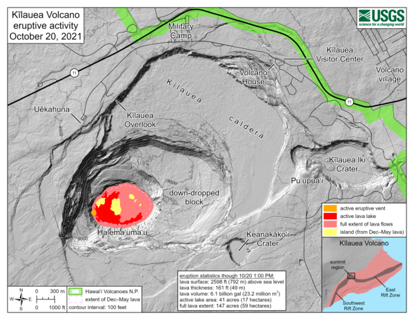
October 20, 2021—Kīlauea summit eruption reference map
October 20, 2021—Kīlauea summit eruption reference mapThis reference map depicts the ongoing Kīlauea summit eruption on October 20, 2021. Only one eruptive vent is active within Halema‘uma‘u at this time, along the western edge of the rising lava lake.

October 15, 2021—Kīlauea summit eruption thermal map
October 15, 2021—Kīlauea summit eruption thermal mapThis detailed thermal map of the Halema‘uma‘u lava lake is a zoomed-in version of the broader map above, constructed from imagery collected during a helicopter overflight on October 15, 2021, at approximately 7:30 a.m. HST.

West vent in Halema‘uma‘u, Kīlauea summit eruption—Oct. 15 2021
West vent in Halema‘uma‘u, Kīlauea summit eruption—Oct. 15 2021A close-up view of the west vent on the western crater wall of Halema‘uma‘u, at Kīlauea summit. Fountaining and lava spatter has built a cone around the vent. Lava pools in the cone and then pours into the lava lake through a small spillway. This photo was taken during a monitoring helicopter overflight on October 15, 2021. USGS photo by N. Deligne.

West vent in Halema‘uma‘u, Kīlauea summit eruption—Oct. 15 2021
West vent in Halema‘uma‘u, Kīlauea summit eruption—Oct. 15 2021A telephoto view of the west vent supplying lava to the lava lake in Halema‘uma‘u, at Kīlauea summit. In the bottom right, the western fissure complex from the Dec. 2020–May 2021 eruption is visible as a spiny dull dark brown and red feature.

Scientist collects data—Kīlauea eruption overflight—Oct. 15, 2021
Scientist collects data—Kīlauea eruption overflight—Oct. 15, 2021Hawaiian Volcano Observatory scientists make observations and collect data during Kīlauea eruption overflights. The data collected is used to construct updated topographic and thermal maps of the lava lake surface and surrounding area.

Active west vent in Halema‘uma‘u—October 15, 2021
A telephoto image of the the west vent taken on the morning of October 15, during an HVO helicopter overflight of Kīlauea summit. Low lava fountaining activity continues from the vent in the western wall of Halema‘uma‘u.
A telephoto image of the the west vent taken on the morning of October 15, during an HVO helicopter overflight of Kīlauea summit. Low lava fountaining activity continues from the vent in the western wall of Halema‘uma‘u.

Halema‘uma‘u Lave Lake—October 15, 2021
The eruption within Halema‘uma‘u continues. Lava fountaining from the western vent (center) feeds a rising lava lake. Activity has decreased over the past week and much of the eastern half of the lake surface (seen here in the foreground) has cooled and formed a solid crust.
The eruption within Halema‘uma‘u continues. Lava fountaining from the western vent (center) feeds a rising lava lake. Activity has decreased over the past week and much of the eastern half of the lake surface (seen here in the foreground) has cooled and formed a solid crust.