
Image showing the active lava lake (silvery area), the west vent complex (lower right), and the main island (upper left) within Halema‘uma‘u crater, at the summit of Kīlauea. Orange lava can be seen spattering on the east side of the active lava lake. USGS photo taken at 9:35 a.m. HST on November 10, 2022, by J.M. Chang.
Images
Kīlauea images of eruptive activity, field work, and more.
Filter Total Items: 3141

November 10, 2022 — Kīlauea Summit Eruption
Image showing the active lava lake (silvery area), the west vent complex (lower right), and the main island (upper left) within Halema‘uma‘u crater, at the summit of Kīlauea. Orange lava can be seen spattering on the east side of the active lava lake. USGS photo taken at 9:35 a.m. HST on November 10, 2022, by J.M. Chang.

November 10, 2022 — Kīlauea Summit Eruption
Panoramic view of Halema‘uma‘u crater, at the summit of Kīlauea, looking eastward from the west rim. HVO scientists continue to monitor Halema‘uma‘u as the summit eruption continues. USGS photo taken on November 10, 2022, by J.M. Chang.
Panoramic view of Halema‘uma‘u crater, at the summit of Kīlauea, looking eastward from the west rim. HVO scientists continue to monitor Halema‘uma‘u as the summit eruption continues. USGS photo taken on November 10, 2022, by J.M. Chang.

October 31, 2022—Kīlauea summit eruption reference map
October 31, 2022—Kīlauea summit eruption reference mapThis reference map depicts the ongoing Kīlauea summit eruption on October 31, 2022. One eruptive vent (orange) is active within Halema‘uma‘u, on the western side of the crater floor. An adjacent pond (purple) is feeding lava to a larger lake (red) via a crusted-over tube.

October 28, 2022 — Kīlauea Summit Aerial Observations
October 28, 2022 — Kīlauea Summit Aerial ObservationsA west-facing aerial view of Halema‘uma‘u crater at the summit of Kīlauea. The right side of the image is framed by the scarp, above the black lava within Halema‘uma‘u, that formed during the 2018 summit collapse. In the center foreground, is the down-dropped block within Kaluapele (the summit caldera), that also formed in 2018.

October 28, 2022 — Kīlauea Summit Aerial Observations
October 28, 2022 — Kīlauea Summit Aerial ObservationsA southwest-facing view of the eruption within Halema‘uma‘u, at the summit of Kīlauea. Diffuse steam and volcanic gases are emitted from the crater floor and eruption site. The most recent Kīlauea summit sulfur dioxide (SO2) emission rate was measured on October 22, 2022, at approximately 700 tonnes per day (t/d). USGS image by K. Mulliken.

October 28, 2022—Kīlauea summit thermal map
A helicopter overflight on October 28, 2022, allowed for aerial visual and thermal imagery to be collected of Halema‘uma‘u crater at the summit of Kīlauea. The active lake surface is limited to the western portion of the crater.
A helicopter overflight on October 28, 2022, allowed for aerial visual and thermal imagery to be collected of Halema‘uma‘u crater at the summit of Kīlauea. The active lake surface is limited to the western portion of the crater.

Halema‘uma‘u crater and lava lake—12 October 2022
Panoramic view of Halema‘uma‘u crater, looking east, at Kīlauea summit. Lava continues to erupt from the west vent complex into the active lava lake. USGS photo taken by F. Trusdell on the morning of October 12, 2022.
Panoramic view of Halema‘uma‘u crater, looking east, at Kīlauea summit. Lava continues to erupt from the west vent complex into the active lava lake. USGS photo taken by F. Trusdell on the morning of October 12, 2022.

Halema‘uma‘u lava lake—12 October 2022
Image of the Kīlauea summit eruption within Halema‘uma‘u crater. The western vent complex (fuming cones in foreground), Halema‘uma‘u lava lake and south pond (silvery surface in center), and large island (darker lava in upper left) and all visible in this view from the west rim. Incandescent lava spatter is visible at the east end of the active lava lake.
Image of the Kīlauea summit eruption within Halema‘uma‘u crater. The western vent complex (fuming cones in foreground), Halema‘uma‘u lava lake and south pond (silvery surface in center), and large island (darker lava in upper left) and all visible in this view from the west rim. Incandescent lava spatter is visible at the east end of the active lava lake.

October 5, 2022 - Active lava lake and western vent complex within Halema‘uma‘u
October 5, 2022 - Active lava lake and western vent complex within Halema‘uma‘uThe eruption continues within Halema‘uma‘u at the summit of Kīlauea. This telephoto, looking east from the rim of Halema‘uma‘u, shows the active lava lake (center), with active lava ponds to the southeast (upper right) and west (lower center). The silvery surface of these three features is the active lava.

October 5, 2022 - Active lava lake and crater floor within Halema‘uma‘u, Kīlauea
October 5, 2022 - Active lava lake and crater floor within Halema‘uma‘u, KīlaueaView of over half of the crater floor and active lava lake (center right) within Halema‘uma‘u at the summit of Kīlauea on October 5, 2022. In this view looking east, all but the southwest portion of Halema‘uma‘u's crater floor is visible. USGS photo by N. Deligne.

UAS mission at Kīlauea summit - October 5, 2022
This photo shows a Unoccupied Aircraft System (UAS) unit staged for take-off on October 5, 2022. Data from this flight will be used to construct an updated high resolution map of Halema‘uma‘u at the summit of Kīlauea.
This photo shows a Unoccupied Aircraft System (UAS) unit staged for take-off on October 5, 2022. Data from this flight will be used to construct an updated high resolution map of Halema‘uma‘u at the summit of Kīlauea.

October 5, 2022—Kīlauea summit UAS thermal maps
Uncrewed aircraft systems (UAS) flights on October 5, 2022, allowed for aerial visual and thermal imagery to be collected of Halema‘uma‘u crater at the summit of Kīlauea. The active lake surface is limited to the western portion of the crater.
Uncrewed aircraft systems (UAS) flights on October 5, 2022, allowed for aerial visual and thermal imagery to be collected of Halema‘uma‘u crater at the summit of Kīlauea. The active lake surface is limited to the western portion of the crater.

2022 Kīlauea GPS Campaign
In September 2022, HVO scientists set up GPS equipment at various benchmarks on Kīlauea volcano as part of routine annual deformation monitoring. USGS photo by A.P. Ellis.
In September 2022, HVO scientists set up GPS equipment at various benchmarks on Kīlauea volcano as part of routine annual deformation monitoring. USGS photo by A.P. Ellis.
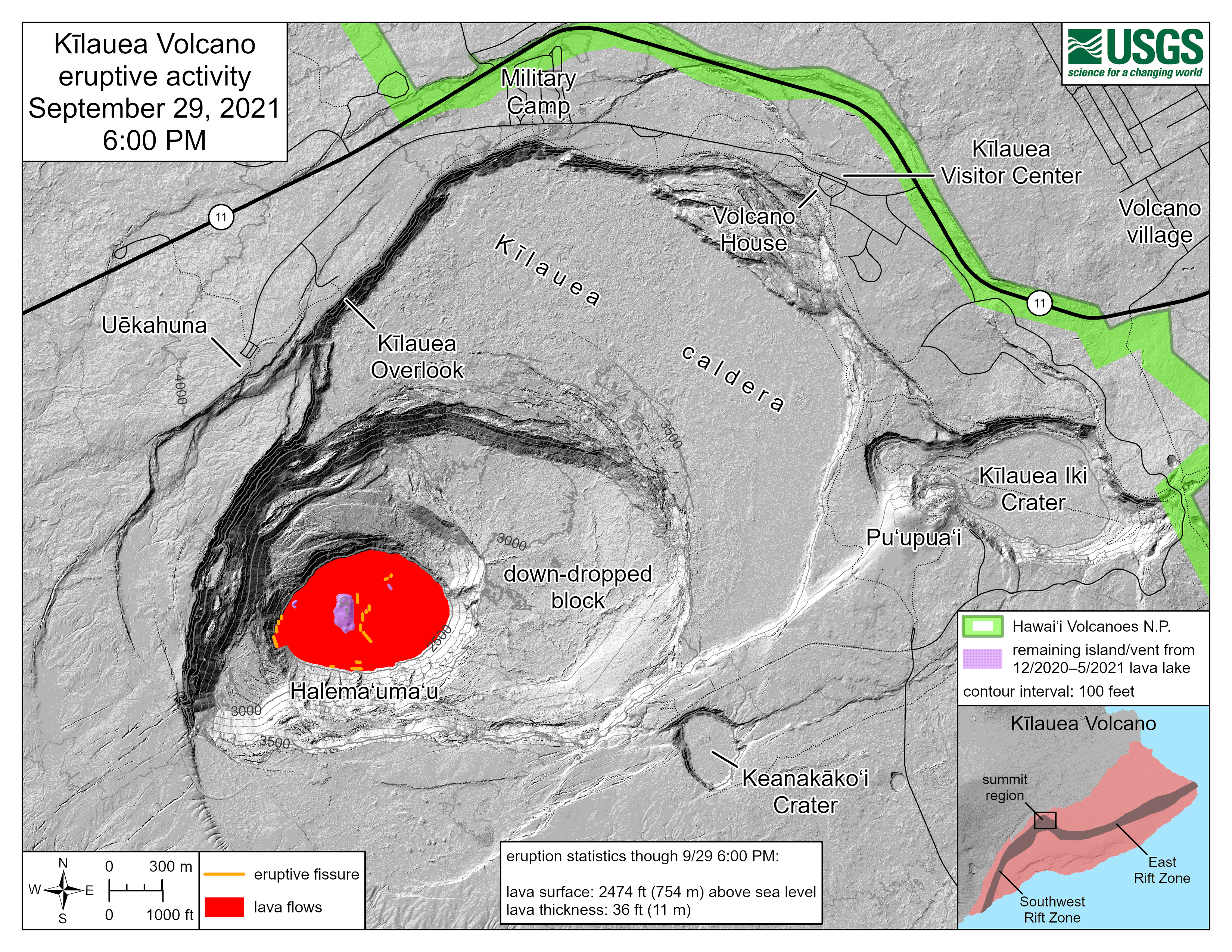
Kīlauea summit eruption reference maps over the past year
Kīlauea summit eruption reference maps over the past yearThis animated gif shows one year of reference maps depicting the ongoing Kīlauea summit eruption, which began on September 29, 2021. The animated gif shows how the active lava lake has decreased in area over the past year, while the crater floor has grown in area.

KWcam image September 29, 2022, at 11:03 a.m. HST
This image, taken from the KWcam around 11 am on September 29, 2022, shows the lava lake and ongoing eruption within Halemaʻumaʻu crater, at the summit of Kīlauea volcano.
This image, taken from the KWcam around 11 am on September 29, 2022, shows the lava lake and ongoing eruption within Halemaʻumaʻu crater, at the summit of Kīlauea volcano.

Kīlauea summit eruption reference map gif of the past year
Kīlauea summit eruption reference map gif of the past yearThis animated gif shows one year of reference maps depicting the ongoing Kīlauea summit eruption, which began on September 29, 2021. The animated gif shows how the active lava lake has decreased in area over the past year, while the crater floor has grown in area.

September 27, 2022, KWcam image of Halemaʻumaʻu crater at Kīlauea's summit
September 27, 2022, KWcam image of Halemaʻumaʻu crater at Kīlauea's summitKWcam image taken on September 27, 2022. The floor of Halemaʻumaʻu has grown in area and elevation due to the ongoing eruption in crater. The island that formed on December 20, 2020, is surrounded by younger lava flows so what is seen on the surface of Halemaʻumaʻu crater floor today represents the oldest and youngest deposits from these recent eruptions!

September 23, 2022 — Kīlauea
On September 20, 2022, a slight drop in lava lake level at the summit of Kīlauea resulted in stagnation of the small lava pond that was supplied by the main lava lake. The drop in lava level left a narrow bridge of solidified lava over the pathway between these two areas USGS photo by M. Patrick.
On September 20, 2022, a slight drop in lava lake level at the summit of Kīlauea resulted in stagnation of the small lava pond that was supplied by the main lava lake. The drop in lava level left a narrow bridge of solidified lava over the pathway between these two areas USGS photo by M. Patrick.

September 23, 2022 — Slight drop in lava lake level at Kīlauea summit
September 23, 2022 — Slight drop in lava lake level at Kīlauea summitFollowing a slight drop in the lava lake and subsidence of the crater floor on September 20, at the summit of Kīlauea, the lava lake level has remained several meters (above ten feet) below its rim. USGS photo by M. Patrick on September 23, 2022.