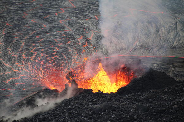
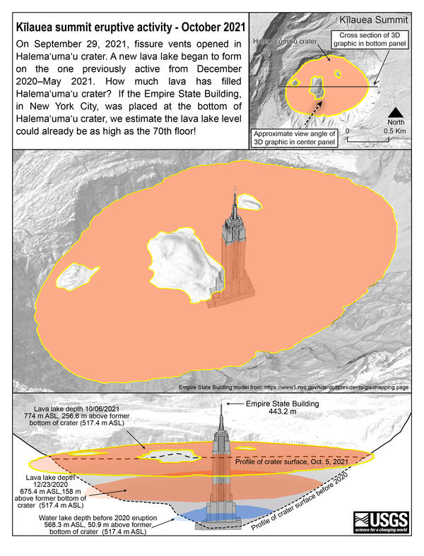
U.S. flag

An official website of the United States government

Images

Kīlauea images of eruptive activity, field work, and more.

Filter Total Items: 2978
More of Kīlauea's lava lake surface in Halema‘uma‘u crater has solidified in recent weeks, evident in this May 13 aerial view
Kīlauea summit overflight - May 13

More of Kīlauea's lava lake surface in Halema‘uma‘u crater has solidified in recent weeks, as is evident in this aerial view taken yesterday, May 13. However, gas emissions and small patches of active lava on the surface indicate that the eruption continues. Most recently, gas emissions were measured as 225 tonnes per day on May 12.

More of Kīlauea's lava lake surface in Halema‘uma‘u crater has solidified in recent weeks, as is evident in this aerial view taken yesterday, May 13. However, gas emissions and small patches of active lava on the surface indicate that the eruption continues. Most recently, gas emissions were measured as 225 tonnes per day on May 12.

A low, oblique aerial view of the west vent in Halema‘uma‘u at Kīlauea's summit
Kīlauea summit overflight - May 13

A low, oblique aerial view of the west vent in Halema‘uma‘u at Kīlauea's summit (upper right) taken during an overflight on May 13. The area of active lava has slowly been decreasing in recent weeks, but not all of the lava lake surface has stagnated. Portions of the lake surface continue to resurface via a process called foundering.

A low, oblique aerial view of the west vent in Halema‘uma‘u at Kīlauea's summit (upper right) taken during an overflight on May 13. The area of active lava has slowly been decreasing in recent weeks, but not all of the lava lake surface has stagnated. Portions of the lake surface continue to resurface via a process called foundering.

Near Kīlauea Visitor Center, the Ha‘akulamanu trail within Hawai‘i Volcanoes National Park passes through the Sulphur Banks area
Kīlauea summit overflight - May 13

Near Kīlauea Visitor Center, the Ha‘akulamanu trail within Hawai‘i Volcanoes National Park passes through the Sulphur Banks area.

Near Kīlauea Visitor Center, the Ha‘akulamanu trail within Hawai‘i Volcanoes National Park passes through the Sulphur Banks area.

USGS Hawaiian Volcano Observatory geologists observed fluid lava on the surface of the lava lake in Halema‘uma‘u, at the summit
Halema‘uma‘u lava lake, Kīlauea summit eruption—May 13, 2021

USGS Hawaiian Volcano Observatory geologists observed fluid lava on the surface of the lava lake in Halema‘uma‘u, at the summit of Kīlauea, while monitoring the eruption on May 13. Two areas of ponded lava exhibited foundering, during which more-dense solidified crust sinks into the lava lake and is replaced by less-dense liquid lava from below.

USGS Hawaiian Volcano Observatory geologists observed fluid lava on the surface of the lava lake in Halema‘uma‘u, at the summit of Kīlauea, while monitoring the eruption on May 13. Two areas of ponded lava exhibited foundering, during which more-dense solidified crust sinks into the lava lake and is replaced by less-dense liquid lava from below.

Digital elevation model of crater and lava lake
Halema‘uma‘u DEM May 13, 2021

A helicopter overflight on May 13, 2021, at approximately 11:30 a.m. HST allowed for aerial visual and thermal imagery to be collected of the eruption within Halema‘uma‘u crater at the summit of Kīlauea Volcano. The visual images were used to create a digital elevation model (DEM) of the crater, shown here.

A helicopter overflight on May 13, 2021, at approximately 11:30 a.m. HST allowed for aerial visual and thermal imagery to be collected of the eruption within Halema‘uma‘u crater at the summit of Kīlauea Volcano. The visual images were used to create a digital elevation model (DEM) of the crater, shown here.

The eruption in Halema‘uma‘u, at the summit of Kīlauea, continues
Halema‘uma‘u lava lake, Kīlauea summit eruption—May 13, 2021

The eruption in Halema‘uma‘u, at the summit of Kīlauea, continues. Gas emissions, last measured on May 12, were 225 tonnes per day. This photo, taken on May 13, shows the bluish-tinged plume of volcanic gas being emitted from the western vent complex within Halema‘uma‘u crater. USGS image by K. Mulliken.

The eruption in Halema‘uma‘u, at the summit of Kīlauea, continues. Gas emissions, last measured on May 12, were 225 tonnes per day. This photo, taken on May 13, shows the bluish-tinged plume of volcanic gas being emitted from the western vent complex within Halema‘uma‘u crater. USGS image by K. Mulliken.

A wide view of Halema‘uma‘u from the western crater rim, at the summit of Kīlauea
Halema‘uma‘u eruption activity on May 12, 2021 — Kīlauea summit

A wide view of Halema‘uma‘u from the western crater rim, at the summit of Kīlauea. The west vent (lower left) continues to supply lava into the lake through a submerged inlet. Much of the western active lava lake surface has crusted over in the last few weeks as the effusion rate remains low. USGS photograph taken by D. Downs on May 12, 2021.

A wide view of Halema‘uma‘u from the western crater rim, at the summit of Kīlauea. The west vent (lower left) continues to supply lava into the lake through a submerged inlet. Much of the western active lava lake surface has crusted over in the last few weeks as the effusion rate remains low. USGS photograph taken by D. Downs on May 12, 2021.

A close up view of the western portion of the lava lake within Halema‘uma‘u, at Kīlauea summit
Halema‘uma‘u eruption activity on May 12, 2021 — Kīlauea summit

A close up view of the western portion of the lava lake within Halema‘uma‘u, at Kīlauea summit. A weak gas plume is emitted from the western fissure vent (left), with the most recent sulfur dioxide emission rate measured at 150 tonnes per day on May 11. USGS photograph taken by D. Downs on May 12, 2021 from the west rim of Halema‘uma‘u.

A close up view of the western portion of the lava lake within Halema‘uma‘u, at Kīlauea summit. A weak gas plume is emitted from the western fissure vent (left), with the most recent sulfur dioxide emission rate measured at 150 tonnes per day on May 11. USGS photograph taken by D. Downs on May 12, 2021 from the west rim of Halema‘uma‘u.

Color map of lava lake at volcano summit
May 7, 2021—Kīlauea summit eruption contour map

This map of Halema‘uma‘u at the summit of Kīlauea shows 20 m (66 ft) contour lines (dark gray) that mark locations of equal elevation above sea level (asl). The map shows that the lava lake has filled 229 m (751 ft) of the crater, to an elevation of 746 m (2448 ft) asl since the eruption began on December 20, 2020.

This map of Halema‘uma‘u at the summit of Kīlauea shows 20 m (66 ft) contour lines (dark gray) that mark locations of equal elevation above sea level (asl). The map shows that the lava lake has filled 229 m (751 ft) of the crater, to an elevation of 746 m (2448 ft) asl since the eruption began on December 20, 2020.

Color photograph of lava lake
Lava lake in Halema‘uma‘u - Kīlauea, May 7 2021

The lava lake in Halema‘uma‘u crater, at the summit of Kīlauea, remains active, as seen in this view looking northwest. The active surface lava area continues to decrease in size, and activity is weaker, with only occasional localized surface foundering.

The lava lake in Halema‘uma‘u crater, at the summit of Kīlauea, remains active, as seen in this view looking northwest. The active surface lava area continues to decrease in size, and activity is weaker, with only occasional localized surface foundering.

Color photograph of lava lake
Close-up view of active western portion of Halema‘uma‘u lava lake

This close-up view of the active western portion of the Halema‘uma‘u lava lake at the summit of Kīlauea was captured on Thursday, May 6 through the lens of a laser rangefinder used by HVO scientists to measure distances to features within the crater.

This close-up view of the active western portion of the Halema‘uma‘u lava lake at the summit of Kīlauea was captured on Thursday, May 6 through the lens of a laser rangefinder used by HVO scientists to measure distances to features within the crater.

Color photograph of lava lake
Halema‘uma‘u lava lake, May 6, 2021

View of the active surface lava in the western portion of Halema‘uma‘u, at the summit of Kīlauea Volcano. The west vent (upper left) continues to erupt lava into the lava lake through an inlet near the base of the cone.

View of the active surface lava in the western portion of Halema‘uma‘u, at the summit of Kīlauea Volcano. The west vent (upper left) continues to erupt lava into the lava lake through an inlet near the base of the cone.

Color photograph of lava lake
Halema‘uma‘u eruptive activity on 05 May 2021

Lava continues to flow from the western vent (bottom left) into the lava lake at Halema‘uma‘u Crater at the summit of Kīlauea Volcano, Island of Hawai‘i. A portion of the active surface of the lava lake can be seen here with orange, incandescent lava between the west vent and the main island. This photograph was taken on Wednesday, March 5, 2021, at 12:37 p.m.

Lava continues to flow from the western vent (bottom left) into the lava lake at Halema‘uma‘u Crater at the summit of Kīlauea Volcano, Island of Hawai‘i. A portion of the active surface of the lava lake can be seen here with orange, incandescent lava between the west vent and the main island. This photograph was taken on Wednesday, March 5, 2021, at 12:37 p.m.

HVO scientists hiked along the closed Crater Rim Road on April 30th to retrieve acoustic (sound) sensors for a scientific study
View of Kīlauea's September 1982 lava flow lobe — April 30, 2021

HVO scientists hiked along the closed Crater Rim Road on April 30th to retrieve acoustic (sound) sensors for a scientific study. This section of the road was damaged by earthquake activity during the 2018 Kīlauea summit caldera collapse. This stretch of road traverses part of the September 1982 lava flow, visible as a lobe of black rock on the right of the road.

HVO scientists hiked along the closed Crater Rim Road on April 30th to retrieve acoustic (sound) sensors for a scientific study. This section of the road was damaged by earthquake activity during the 2018 Kīlauea summit caldera collapse. This stretch of road traverses part of the September 1982 lava flow, visible as a lobe of black rock on the right of the road.

Hiking along the rim of the 2018 collapse area at the summit of Kīlauea
View of Kīlauea summit eruption gas plume from southeast — April 30

While hiking along the rim of the 2018 collapse area at the summit of Kīlauea, HVO scientists visited a site to the southeast of Halema‘uma‘u known as Akanikōlea—a culturally-significant place that is featured in Hawaiian legends.

While hiking along the rim of the 2018 collapse area at the summit of Kīlauea, HVO scientists visited a site to the southeast of Halema‘uma‘u known as Akanikōlea—a culturally-significant place that is featured in Hawaiian legends.

On Friday, April 30, lava continued to erupt from the west vent in Halema‘uma‘u at the summit of Kīlauea Volcano
Halema‘uma‘u lava lake, Kīlauea summit eruption—April 30, 2021

On Friday, April 30, lava continued to erupt from the west vent in Halema‘uma‘u at the summit of Kīlauea Volcano. Active surface lava (center of the photo) was limited to the center of the previously active lake surface, where the north (right) and south (left) sides have cooled and crusted over (appearing darker in the image). This photo was taken around 2 p.m.

On Friday, April 30, lava continued to erupt from the west vent in Halema‘uma‘u at the summit of Kīlauea Volcano. Active surface lava (center of the photo) was limited to the center of the previously active lake surface, where the north (right) and south (left) sides have cooled and crusted over (appearing darker in the image). This photo was taken around 2 p.m.

The lava lake in Halema‘uma‘u crater, at the summit of Kīlauea, remains active
View of lava lake in Halema‘uma‘u—Kīlauea, April 27, 2021

The lava lake in Halema‘uma‘u crater, at the summit of Kīlauea, remains active, as seen in this view looking north. Active surface lava is limited to the western (left) portion of the lake between the main island and the western fissure complex.

The lava lake in Halema‘uma‘u crater, at the summit of Kīlauea, remains active, as seen in this view looking north. Active surface lava is limited to the western (left) portion of the lake between the main island and the western fissure complex.

A close-up view of the west vent spatter cones and lava lake inlet in Halema‘uma‘u Crater at the summit of Kīlauea Volcano
Close-up view of the west vent and inlet at Halema‘uma‘u

A close-up view of the west vent spatter cones (bottom left) and inlet where lava is entering the lava lake (center right) in Halema‘uma‘u Crater at the summit of Kīlauea Volcano. A piece of crust, that solidified near the inlet, broke off and was being transported away from the inlet. This photograph was taken on April 26, 2021, at 1:51 p.m.

A close-up view of the west vent spatter cones (bottom left) and inlet where lava is entering the lava lake (center right) in Halema‘uma‘u Crater at the summit of Kīlauea Volcano. A piece of crust, that solidified near the inlet, broke off and was being transported away from the inlet. This photograph was taken on April 26, 2021, at 1:51 p.m.

On Monday, April 26, 2021, lava continued to flow from the western vent into the active lava lake in Halema‘uma‘u Crater
View of Halema‘uma‘u lava lake from the west, April 26, 2021

On Monday, April 26, 2021, lava continued to flow from the western vent (bottom left) into the active lava lake (center) in Halema‘uma‘u Crater at the summit of Kīlauea Volcano. The active lava lake surface continues to shrink as areas on the north (upper left) and south (center right) sides cool and solidify. This photograph was taken at 1:03 p.m.

On Monday, April 26, 2021, lava continued to flow from the western vent (bottom left) into the active lava lake (center) in Halema‘uma‘u Crater at the summit of Kīlauea Volcano. The active lava lake surface continues to shrink as areas on the north (upper left) and south (center right) sides cool and solidify. This photograph was taken at 1:03 p.m.

Color photograph of lava lake surface
April 22, 2021- Close-up view of Halema‘uma‘u lava lake crusting-over

This zoomed-in photo of the far southwest end of the active lava lake within Halema‘uma‘u at Kīlauea's summit was captured on Thursday, April 22, and it illustrates the process by which parts of the lava lake become inactive.

This zoomed-in photo of the far southwest end of the active lava lake within Halema‘uma‘u at Kīlauea's summit was captured on Thursday, April 22, and it illustrates the process by which parts of the lava lake become inactive.

Color map of lava
April 23, 2021—Kīlauea summit eruption contour map

This map of Halema‘uma‘u at the summit of Kīlauea shows 20 m (66 ft) contour lines (dark gray) that mark locations of equal elevation above sea level (asl). The map shows that the lava lake has filled 228 m (748 ft) of the crater, to an elevation of 745 m (2444 ft) asl since the eruption began on December 20, 2020.

This map of Halema‘uma‘u at the summit of Kīlauea shows 20 m (66 ft) contour lines (dark gray) that mark locations of equal elevation above sea level (asl). The map shows that the lava lake has filled 228 m (748 ft) of the crater, to an elevation of 745 m (2444 ft) asl since the eruption began on December 20, 2020.

Was this page helpful?