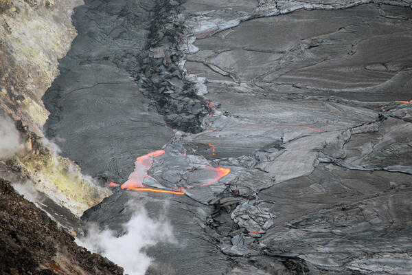
Lava continues to eruption from a vent on the western wall of Halema‘uma‘u crater and flow into the lava lake. The active area of the lava lake remains similar in size to the previous week. In the foreground, a down-dropped block containing a segment of the old Crater Rim Drive can be seen. The southeast flank of Mauna Loa is in the background.
Images
Kīlauea images of eruptive activity, field work, and more.
Lava continues to eruption from a vent on the western wall of Halema‘uma‘u crater and flow into the lava lake. The active area of the lava lake remains similar in size to the previous week. In the foreground, a down-dropped block containing a segment of the old Crater Rim Drive can be seen. The southeast flank of Mauna Loa is in the background.
November 19, 2021—Kīlauea summit eruption reference map
November 19, 2021—Kīlauea summit eruption reference mapThis reference map depicts the ongoing Kīlauea summit eruption on November 19, 2021. One eruptive vent is active within Halema‘uma‘u at this time, along the western edge of the rising lava lake.
November 19, 2021—Kīlauea summit eruption reference map
November 19, 2021—Kīlauea summit eruption reference mapThis reference map depicts the ongoing Kīlauea summit eruption on November 19, 2021. One eruptive vent is active within Halema‘uma‘u at this time, along the western edge of the rising lava lake.
A telephoto photograph of the roiling 4-7 meter (13-23 ft) lava fountains of the western vent in Halema‘uma‘u crater at the summit of Kīlauea. The spatter cone is nearly circular, with only one outlet letting lava cascade east into the lake. Concentric lava crust rings form around where lava enters the lake from a single source with persistent flux.
The ongoing eruption at Kīlauea summit continues to fill Halemaʻumaʻu crater with lava. A gas plume rises from the active vent on the west (left) side of the crater as lava flows from the vent into the rising lava lake (black surface).
Aerial view of eastern half of Kīlauea summit caldera
Aerial view of eastern half of Kīlauea summit calderaAerial view looking northeast of the eastern half of the Kīlauea summit caldera, taken during a helicopter overflight of the Kīlauea summit on the morning of November 16, 2021. The current lava lake in Halema‘uma‘u is visible in bottom left, and scarps associated with 2018 Kīlauea summit collapse are prominent in the center of the photo.
Aerial view of eastern half of Kīlauea summit caldera
Aerial view of eastern half of Kīlauea summit calderaAerial view looking northeast of the eastern half of the Kīlauea summit caldera, taken during a helicopter overflight of the Kīlauea summit on the morning of November 16, 2021. The current lava lake in Halema‘uma‘u is visible in bottom left, and scarps associated with 2018 Kīlauea summit collapse are prominent in the center of the photo.
Thermal image of Halema‘uma‘u lava lake on November 16, 2021
Thermal image of Halema‘uma‘u lava lake on November 16, 2021This thermal image is looking west and shows the lava lake in Halema‘uma‘u, at the summit of Kīlauea. The active lava on the surface is limited to the west side of the lake, near the west vent. The eastern portion is solidified at the surface, with small ooze-outs often active along the lake perimeter.
Thermal image of Halema‘uma‘u lava lake on November 16, 2021
Thermal image of Halema‘uma‘u lava lake on November 16, 2021This thermal image is looking west and shows the lava lake in Halema‘uma‘u, at the summit of Kīlauea. The active lava on the surface is limited to the west side of the lake, near the west vent. The eastern portion is solidified at the surface, with small ooze-outs often active along the lake perimeter.
A helicopter overflight on November 16, 2021, at approximately 8:30 a.m. HST allowed for aerial visual and thermal imagery to be collected of Halema‘uma‘u crater at the summit of Kīlauea. The scale of the thermal map ranges from blue to red, with blue colors indicative of cooler temperatures and red colors indicative of warmer temperatures.
Lava flow onto lowest exposed Kīlauea summit down-dropped block
Lava flow onto lowest exposed Kīlauea summit down-dropped blockThe elevation of the surface of the lava lake within Halema‘uma‘u crater has now risen slightly above the level of the lowest down-dropped block from the 2018 collapse of Kīlauea summit. Overnight on November 15, 2021, a lava break-out from the edge of the lake allowed lava to flow onto the surface on the block.
Lava flow onto lowest exposed Kīlauea summit down-dropped block
Lava flow onto lowest exposed Kīlauea summit down-dropped blockThe elevation of the surface of the lava lake within Halema‘uma‘u crater has now risen slightly above the level of the lowest down-dropped block from the 2018 collapse of Kīlauea summit. Overnight on November 15, 2021, a lava break-out from the edge of the lake allowed lava to flow onto the surface on the block.
HVO geologists observed ongoing eruptive activity with Halema‘uma‘u crater during a helicopter overflight of the Kīlauea summit on the morning of November 16, 2021. Lava continues to erupt from a vent on the west side (far side in this photo) of Halema‘uma‘u. Low winds allowed the plume to rise vertically above the crater.
During a helicopter overflight of Kīlauea summit on the morning of November 16, 2021, this aerial view (looking southwest) of the lava flow erupted in September 1982 was captured. The September 1982 lava flow exited Kīlauea summit caldera through a narrow gap, visible near the center of the photo.
A helicopter overflight on November 16, 2021, at approximately 8:30 a.m. HST allowed for aerial visual and thermal imagery to be collected of Halema‘uma‘u crater at the summit of Kīlauea. The scale of the thermal map ranges from blue to red, with blue colors indicative of cooler temperatures and red colors indicative of warmer temperatures.
During a helicopter overflight on November 16, 2021, HVO scientists monitored a thermal steaming area near Heiheiahulu, on Kīlauea's middle East Rift Zone. The expanse of this thermal area has not changed or expanded significantly since the previous overflight of the area in March 2021.
November 15, 2021 — Kīlauea, flow on south side of west vent cone
November 15, 2021 — Kīlauea, flow on south side of west vent coneA telephoto view of the flow on the south side of the west vent cone within Halema‘uma‘u crater, at the summit of Kīlauea. The direction of flow is from the west (bottom) to the east (top). Entrained pieces of solidified crust (black) can be seen in the flow and can be used to determine the direction of flow.
November 15, 2021 — Kīlauea, flow on south side of west vent cone
November 15, 2021 — Kīlauea, flow on south side of west vent coneA telephoto view of the flow on the south side of the west vent cone within Halema‘uma‘u crater, at the summit of Kīlauea. The direction of flow is from the west (bottom) to the east (top). Entrained pieces of solidified crust (black) can be seen in the flow and can be used to determine the direction of flow.
A view of the active west vent within Halema‘uma‘u crater, at the summit of Kīlauea, on November 15, 2021. A new flow has developed on the south side of the west vent cone (right side of photo), with lava moving from a source near the base of the cone toward the lava lake. Photo taken at 12:55 p.m. HST from the western rim of the crater. USGS photo by J.M.
November 12, 2021 — Kīlauea telephoto view of west vent spatter
November 12, 2021 — Kīlauea telephoto view of west vent spatterA telephoto view of spatter erupting from the west vent in Halema‘uma‘u crater, at the summit of Kīlauea. Photo taken at 2:42 p.m. HST on Nov. 12, 2021, from the western rim. USGS photo by J.M. Chang.
November 12, 2021 — Kīlauea telephoto view of west vent spatter
November 12, 2021 — Kīlauea telephoto view of west vent spatterA telephoto view of spatter erupting from the west vent in Halema‘uma‘u crater, at the summit of Kīlauea. Photo taken at 2:42 p.m. HST on Nov. 12, 2021, from the western rim. USGS photo by J.M. Chang.
Overflow of Halema‘uma‘u lava lake levee—Kīlauea summit
Overflow of Halema‘uma‘u lava lake levee—Kīlauea summitA telephoto view of a small overflow to the north of the west vent in Halema‘uma‘u crater, at the summit of Kīlauea. The flow direction is from east (top) to west (bottom) in the photo, and the height of the overflow is approximately 1 meter (3.3 feet). Black chunks of cooled crust can be seen entrained in the flow. Photo taken at 1:18 p.m. HST on Nov.
Overflow of Halema‘uma‘u lava lake levee—Kīlauea summit
Overflow of Halema‘uma‘u lava lake levee—Kīlauea summitA telephoto view of a small overflow to the north of the west vent in Halema‘uma‘u crater, at the summit of Kīlauea. The flow direction is from east (top) to west (bottom) in the photo, and the height of the overflow is approximately 1 meter (3.3 feet). Black chunks of cooled crust can be seen entrained in the flow. Photo taken at 1:18 p.m. HST on Nov.
November 12, 2021 — Kīlauea West vent cone and overflow
November 12, 2021 — Kīlauea West vent cone and overflowView of the west vent cone and outlet channel in Halema‘uma‘u crater, at the summit of Kīlauea. On the lower left is an overflow (orange), where lava breached a levee and started flowing into a lower area to the west. Photo taken at 1:40 p.m. HST on Nov. 12, 2021, from the western rim. USGS photo by J.M. Chang.
November 12, 2021 — Kīlauea West vent cone and overflow
November 12, 2021 — Kīlauea West vent cone and overflowView of the west vent cone and outlet channel in Halema‘uma‘u crater, at the summit of Kīlauea. On the lower left is an overflow (orange), where lava breached a levee and started flowing into a lower area to the west. Photo taken at 1:40 p.m. HST on Nov. 12, 2021, from the western rim. USGS photo by J.M. Chang.
Lava continues to erupt from the west vent in Halema‘uma‘u, and supply the lava lake through a spillway in the spatter cone. On November 12, a small overflow of the perched lava lake levee was visible from the western crater rim. Overflows are an important process for building up perched levees, as they help add height and stability.
November 12, 2021 — Kīlauea telephoto view of overflow
November 12, 2021 — Kīlauea telephoto view of overflowA telephoto view of the overflow north of the west vent in Halema‘uma‘u crater, at the summit of Kīlauea. The flow direction is from east (top) to west (bottom) in the photo, and the height of the overflow is approximately 1 meter (3.3 feet). Black chunks of cooled crust can be seen entrained in the flow. Photo taken at 1:18 p.m. HST on Nov.
November 12, 2021 — Kīlauea telephoto view of overflow
November 12, 2021 — Kīlauea telephoto view of overflowA telephoto view of the overflow north of the west vent in Halema‘uma‘u crater, at the summit of Kīlauea. The flow direction is from east (top) to west (bottom) in the photo, and the height of the overflow is approximately 1 meter (3.3 feet). Black chunks of cooled crust can be seen entrained in the flow. Photo taken at 1:18 p.m. HST on Nov.
November 11, 2021—Kīlauea summit eruption reference map
November 11, 2021—Kīlauea summit eruption reference mapThis reference map depicts the ongoing Kīlauea summit eruption on November 11, 2021. One eruptive vent is active within Halema‘uma‘u at this time, along the western edge of the rising lava lake.
November 11, 2021—Kīlauea summit eruption reference map
November 11, 2021—Kīlauea summit eruption reference mapThis reference map depicts the ongoing Kīlauea summit eruption on November 11, 2021. One eruptive vent is active within Halema‘uma‘u at this time, along the western edge of the rising lava lake.
HVO geologists conducted a helicopter overflight of Halema‘uma‘u, at the summit of Kīlauea, on the morning of November 9. A gas plume can be seen rising from the west vent along the crater wall (center left). Mauna Loa is visible in the background. USGS photo by B. Carr.