An official website of the United States government
Here's how you know
Official websites use .gov
A .gov website belongs to an official government organization in the United States.
Secure .gov websites use HTTPS
A lock () or https:// means you’ve safely connected to the .gov website. Share sensitive information only on official, secure websites.
A new eruption at Kīlauea's summit began at approximately 3:20 p.m. HST on September 29, 2021. Lava activity is currently confined within Halema'uma'u crater. Gas emissions and seismic activity at the summit remain elevated. HVO field crews—equipped with specialized safety gear—monitor the eruption from within the closed area of Hawai‘i V
HVO scientists collect detailed data to assess hazards and understand how the eruption is evolving at Kīlauea's summit, all of which are shared with the National Park Service and emergency managers. Access to this hazardous area is by permission from, and in coordination with, Hawai‘i Volcanoes National Park.
A new Kīlauea summit eruption within Halema‘uma‘u crater began at approximately 3:20 p.m. HST on September 29, 2021, with fountains appearing on the central crater floor, creating a new lava lake. This video shows numerous fountaining sources in the central portion of the lava lake during the evening of September 29, 2021. USGS video by M. Patrick.
A new Kīlauea summit eruption within Halema‘uma‘u crater began at approximately 3:20 p.m. HST on September 29, 2021, with fountains appearing on the central crater floor, where a lava lake had been active from December 2020 until May 2021. Just after 4:40 p.m., a new vent opened on the west wall of the crater, and the initial moments were captured in this video. USGS video by M. Patrick.
A new Kīlauea summit eruption within Halema‘uma‘u crater began at approximately 3:20 p.m. HST on September 29, 2021, with fountains appearing on the central crater floor, creating a new lava lake. This video shows numerous vents active on the west crater wall. USGS video by M. Patrick.
A new Kīlauea summit eruption within Halema‘uma‘u crater began at approximately 3:20 p.m. HST on September 29, 2021, with fountains appearing on the central crater floor, creating a new lava lake. This video shows the dominant fountain, south of the lake center, on the evening of September 29, 2021. USGS video by M. Patrick.
Kīlauea volcano is erupting. With the summit eruption continuing through the night, HVO scientists monitor the eruption for changes in activity and volcanic hazards. High levels of volcanic gases are the primary hazard of concern, as this hazard can have far-reaching effects down-wind. USGS photo taken by D. Downs.
Tephra from the recent eruption within Halema'uma'u, at Kīlauea summit, is accumulating downwind of the active vents. Tephra is a term that describes products of an eruption that travel through the air before being deposited. Tephra products include cinder, pumice, Pele’s Hair and Pele’s tears, which form during lava fountaining, and are light weight and can be wafted downwind with the plume. This photo shows a piece of tephra, approximately 10 cm (4 inches) long that was deposited southwest of the crater. USGS image by K. Lynn.
A Hawaiian Volcano Observatory geologist collects a sample of tephra from the recent eruption within Halema'uma'u, at Kīlauea summit. Geochemical analyses of these eruption products will provide information about magma storage prior to the eruption. USGS image by K. Lynn.
The eruption within Halema'uma'u, at Kīlauea summit within Hawai'i Volcanoes National Park, continues at dawn on September 30, 2021. Fountaining at multiple fissure locations on the base and west wall of the crater continues, and a lava lake is growing within Halema'uma'u. The Kīlauea summit webcams provide near real-time views of this activity: https://www.usgs.gov/volcanoes/kilauea/summit-webcams. USGS image by B. Carr.
The ongoing Kīlauea summit eruption within Halema'uma'u crater continues to feed low lava fountains in the center of the lava lake (pictured) and along the western wall of Halema'uma'u. This telephoto image is looking east at the center of the rising lava lake. The solid dark area below the fountains is the "lava island" that formed in December 2020 in the opeining hours of the last summit eruption. USGS photo taken by M. Patrick on September 29, 2021.
A telephoto image of one of the low lava fountains near the center of the growing Halema'uma'u lava lake. The ongoing eruption at the summit of Kīlauea is confined within Halema'uma'u, with numerous lava fountains producing lava and volcanic gases. Hawaiian Volcano Observatory scientists are monitoring the new eruption from an area within Hawai'i Volcanoes National Park that remains closed to the public due to safety reasons. USGS photo by M. Patrick.
Telephoto aerial image of eruption in Halemaʻumaʻu at Kīlauea Volcano's summit taken during an overflight at approximately 7:30 a.m. HST on September 30, 2021. The active vent in the west wall of Halemaʻumaʻu is vigorously fountaining, and is one of many fountaining sources active in the lava lake right now. The currently inactive west vent, which erupted during the December 2020-May 2021 eruption in Halemaʻumaʻu, is visible in the lower right corner of the image. USGS image by K. Mulliken.
Oblique aerial image of eruption in Halemaʻumaʻu at Kīlauea Volcano's summit taken during an overflight at approximately 7:30 a.m. HST on September 30, 2021. This view shows multiple active spattering sources in southern central part of Halemaʻumaʻu, and associated plumes of volcanic gas. The island that formed during the early phase of the December 2020-May 2021 eruption is visible in the lower right portion of the image and the steep south wall of Halemaʻumaʻu is visible in the background. USGS image by K. Mulliken.
Oblique telephoto aerial image of eruption in Halemaʻumaʻu at Kīlauea Volcano's summit taken during an overflight at approximately 7:30 a.m. HST on September 30, 2021. Spattering sources on the east side of the island that formed in the previous December 2020-May 2021 eruption are visible in the foreground of the image, whereas the prominent vent in the west wall is visible in the background. USGS image by K. Mulliken.
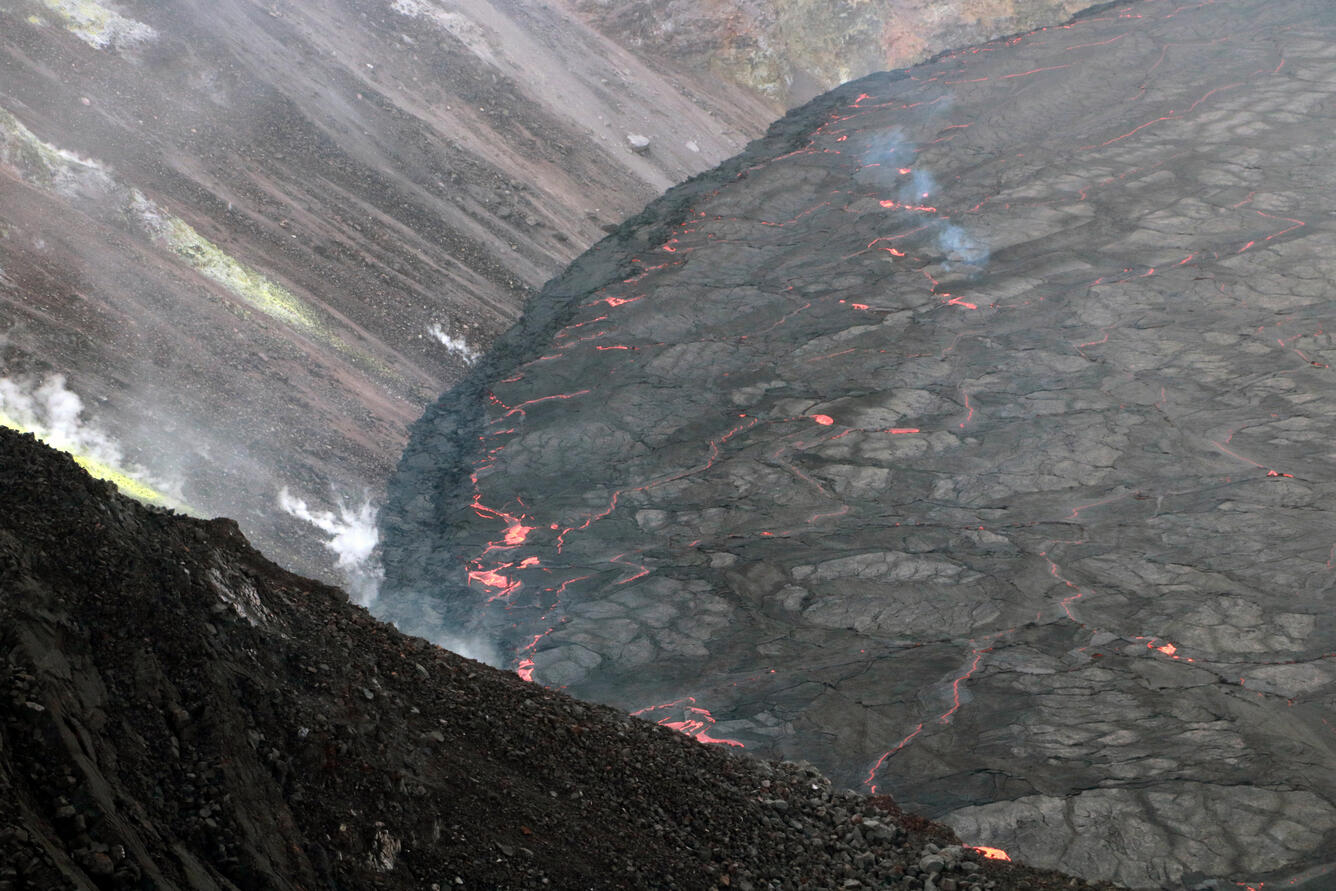
Telephoto aerial image of eruption in Halemaʻumaʻu at Kīlauea Volcano's summit taken during an overflight at approximately 7:30 a.m. HST on September 30, 2021. This photo shows the eastern portoin of the nascent lava lake, where it meets the wall of Halemaʻumaʻu crater. The lava lake has not exhibited widespread circulation overnight, with localized and discontinuous areas of crustal foundering (a process by which cool lava crust on the surface of the lava lake is overridden by less-dense liquid from below causing the crust to sink into the underlying lake lava). A narrow levee, visible as the darker band where the lava lake meets the crater wall, is forming along the perimeter of the lava lake. USGS image by K. Mulliken.
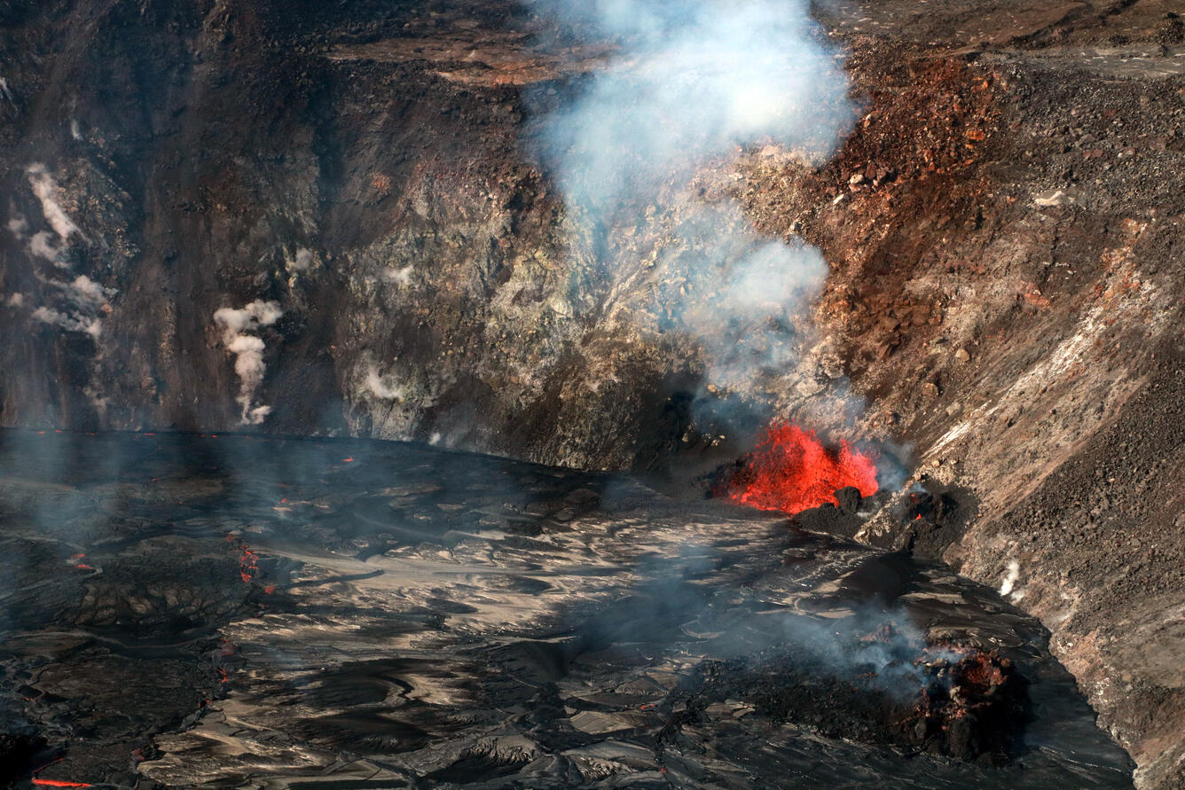
Telephoto aerial image of eruption in Halemaʻumaʻu at Kīlauea Volcano's summit taken during an overflight at approximately 7:30 a.m. HST on September 30, 2021. This photo shows two of the many spattering sources active in the base of Halemaʻumaʻu, feeding the growing lava lake. The south wall of Halemaʻumaʻu crater is visible in the upper left portion of the image. USGS image by K. Mulliken.
Telephoto aerial image of eruption in Halemaʻumaʻu at Kīlauea Volcano's summit taken during an overflight at approximately 7:30 a.m. HST on September 30, 2021. A series of fountains in the central portion of the lava lake are visible, as well as the prominent vent in the west wall of Halemaʻumaʻu. The island, which formed during the early phase of the December 2020-May 2021 eruption within Halemaʻumaʻu, remains above the new lava lake surface and is visible in the center of the photo. USGS image by K. Mulliken.
Telephoto aerial image of eruption in Halemaʻumaʻu at Kīlauea Volcano's summit taken during an overflight at approximately 7:30 a.m. HST on September 30, 2021. This photo shows several of the fountaining sources on the base of Halemaʻumaʻu, which are only a few meters (yards) high. USGS image by K. Mulliken.
Aerial image of eruption in Halemaʻumaʻu at Kīlauea Volcano's summit taken during an overflight at approximately 7:30 a.m. HST on September 30, 2021. The nascent lava lake has been rising approximately one meter (yard) an hour since the eruption began. The lava lake has not exhibited widespread circulation overnight, with localized and discontinuous areas of crustal foundering (a process by which cool lava crust on the surface of the lava lake is overridden by less-dense liquid from below causing the crust to sink into the underlying lake lava). USGS image by K. Mulliken.
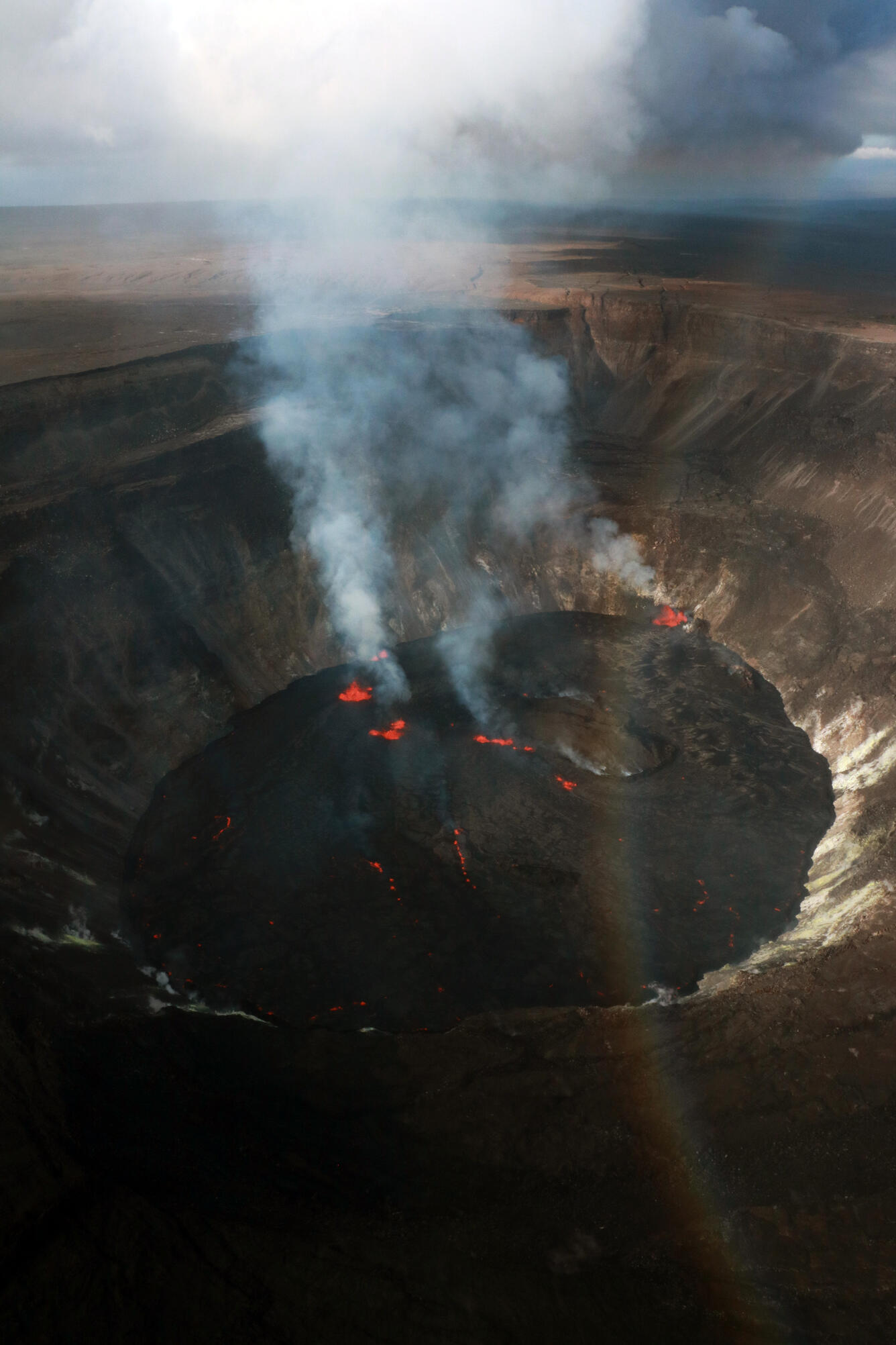
Aerial image of eruption in Halemaʻumaʻu at Kīlauea Volcano's summit taken during an overflight at approximately 7:30 a.m. HST on September 30, 2021. Lava continues to erupt from multiple vents along the floor and western wall of Halemaʻumaʻu crater. As of this afternoon all lava activity is confined within Halemaʻumaʻu Crater. Seismicity and volcanic gas emission rates remain elevated. USGS image by K. Mulliken.
Aerial image of eruption in Halemaʻumaʻu at Kīlauea Volcano's summit taken during an overflight at approximately 7:30 a.m. HST on September 30, 2021. In this image, multiple active fountaining sources are visible in the central and western portions of Halemaʻumaʻu. The maximum fountain height so far, observed yesterday, was estimated to be 25-30 m (82-98 ft) high, though most fountains are currently only a few meters (yards) high. USGS image by K. Mulliken.
Aerial image of eruption in Halemaʻumaʻu at Kīlauea Volcano's summit taken during an overflight at approximately 7:30 a.m. HST on September 30, 2021. The eruption is generating a vigorous plume of volcanic gas, including sulfur dioxide, being transported downwind. Sulfur dioxide emission rates were estimated at around 85,000 tonnes per day just after the eruption started yesterday afternoon at 3:21 p.m. HST. A rainbow is also visible; rainbows are often observed over Halema‘uma‘u, as mist and rain move across the caldera. USGS image by K. Mulliken.
An eruption in Halema‘uma‘u crater, at the summit of Kīlauea, began yesterday afternoon and continues this morning. During an overflight at approximately 7:30 a.m. HST on September 30, 2021, several fountaining sources were active in the crater, including those in the lake center and on the west wall. USGS video by M. Patrick.
This thermal image was taken during the morning overflight and looks west across Halema‘uma‘u crater, at the summit of Kīlauea. Several fountains are emerging through the active lake surface, in addition to fountaining on the west margin of the lake. The island remains near the center of the lake, and a small portion of the western cone, active during the previous eruption earlier this year, is still exposed. USGS image by M. Patrick.
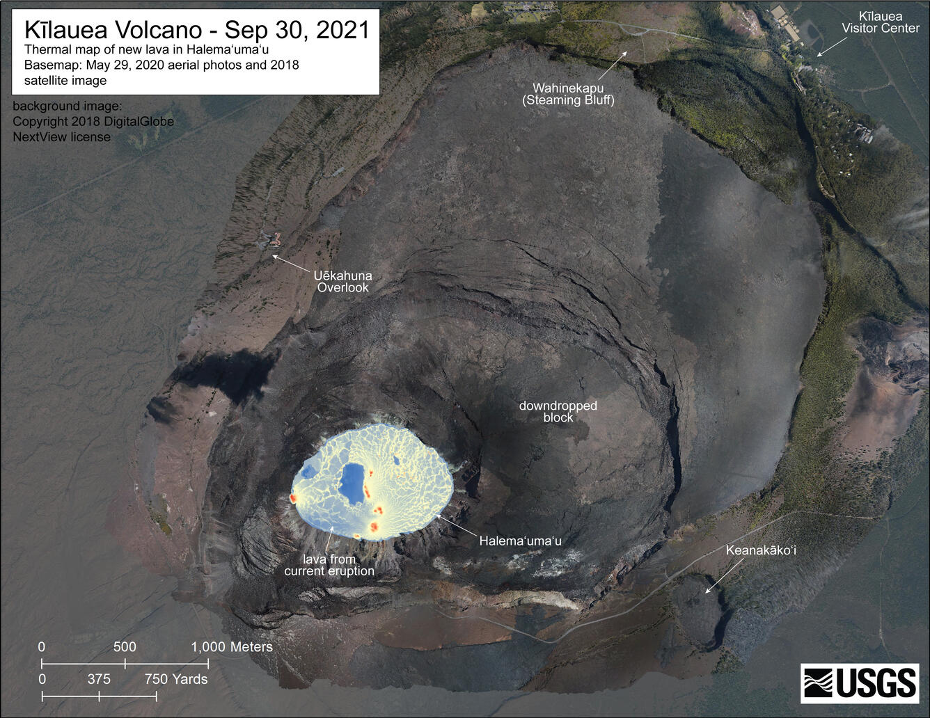
A helicopter overflight on September 30, 2021, at approximately 7:30 a.m. HST allowed for aerial visual and thermal imagery to be collected of Halema‘uma‘u crater at the summit of Kīlauea. This thermal map shows a closer view of the new lava lake within Halema‘uma‘u. The scale of the thermal map ranges from blue to red, with blue colors indicative of cooler temperatures and red colors indicative of warmer temperatures. The dimensions of the new lava lake are 980 m (1070 yd) E-W axis and 710 m (780 yd) in N-S axis. The estimated area of the lake is about 52 hectares (127 acres). USGS map by M. Patrick.
A helicopter overflight on September 30, 2021, at approximately 7:30 a.m. HST allowed for aerial visual and thermal imagery to be collected of Halema‘uma‘u crater at the summit of Kīlauea. This thermal map shows the extent of the new lava lake within Halema‘uma‘u. The scale of the thermal map ranges from blue to red, with blue colors indicative of cooler temperatures and red colors indicative of warmer temperatures. The dimensions of the new lava lake are 980 m (1070 yd) E-W axis and 710 m (780 yd) in N-S axis. The estimated area of the lake is about 52 hectares (127 acres). USGS map by M. Patrick.
This image from the northwest rim of Halema'uma'u crater was taken in the late morning on September 29, 2021, just a few hours before the new Kīlauea summit eruption began. The solidified lava lake (center) was emplaced between December 2020 and May 2021. USGS photo taken by L. Gallant.
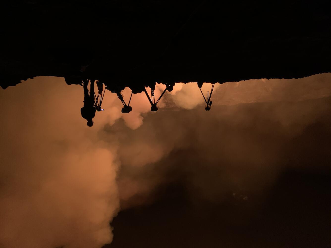
Photo of the new lava lake within Halema'uma'u crater at Kīlauea summit taken early in the morning on September 30. This view from the northwest rim of Halema'uma'u shows two webcams facing the new eruption, with fissures producing lava that is accumulating within the crater. USGS Hawaiian Volcano Observatory scientists continue to monitor the ongoing eruption from within an area of Hawai'i Volcanoes National Park that remains closed to the public due to safety concerns. USGS photo taken by L. Gallant.
This timelapse image sequence shows the opening sequence of the new eruption in Halema‘uma‘u crater, at the summit of Kīlauea. The first few moments are shown on a loop several times to highlight the visible uplift of the crater floor, just before the appearance of new fissures. To see the uplift, focus on the nearest portion of the island in the center of the crater. This shows the bulging of the ground as magma was intruding towards the surface. The remainder of the video shows the spreading of lava across the former lava lake as the fountaining continues.