
Schematic illustration of waterfall formation in which a hard rock that is more resistant to erosion is atop a softer rock that is less resistant to erosion. Source: Wikimedia (https://commons.wikimedia.org/wiki/File:WaterfallCreationDiagram.svg).
Images
Images of Yellowstone.
Filter Total Items: 697

Schematic illustration of waterfall formation
Schematic illustration of waterfall formation in which a hard rock that is more resistant to erosion is atop a softer rock that is less resistant to erosion. Source: Wikimedia (https://commons.wikimedia.org/wiki/File:WaterfallCreationDiagram.svg).

Installing geophysical boreholes in Yellowstone
UNAVCO engineers drilling a borehole for instrument installation (left). Aerial view of borehole casing used to protect instruments from the elements found below the surface (right).
UNAVCO engineers drilling a borehole for instrument installation (left). Aerial view of borehole casing used to protect instruments from the elements found below the surface (right).

Gas flows up, appearing to boil, through the water of Alluvium Cree...
Gas flows up, appearing to boil, through the water of Alluvium Cree...Gas flows up, appearing to boil, through the water of Alluvium Creek, Brimstone Basin, Yellowstone. Large funnel is used to trap gas, which is then sent to a collection bottle through the tubing.

Gas flux measurement taken over altered ground at Brimstone Basin
Gas flux measurement taken over altered ground at Brimstone BasinGas flux measurement being taken over altered ground at Brimstone Basin, Yellowstone.
Gas flux measurement taken over altered ground at Brimstone Basin
Gas flux measurement taken over altered ground at Brimstone BasinGas flux measurement being taken over altered ground at Brimstone Basin, Yellowstone.

Terrace Springs, northeast of Madison Junction, Yellowstone National Park
Terrace Springs, northeast of Madison Junction, Yellowstone National ParkThe water at Terrace Springs, northeast of Madison Junction in Yellowstone National Park, is relatively cold (about 60 °C or 140 °F), but the water is still saturated with CO2-rich bubbles. Photo by Shaul Hurwitz in September 2008.
Sulfur flow at Brimstone Basin, Yellowstone National Park
Sulfur flow at Brimstone Basin, Yellowstone National ParkA sulfur flow over acid-sulfate ground at Brimstone Basin near the eastern shore of Yellowstone Lake. The flows formed when native sulfur deposits were ignited during a forest fire. Photo by Shaul Hurwitz, September 2008.

Roadcut in the Lava Creek Tuff near Tuff Cliff, Yellowstone National Park
Roadcut in the Lava Creek Tuff near Tuff Cliff, Yellowstone National ParkRoadcut in light pink ash-flow deposits of the Lava Creek Tuff on Grand Loop Road near Tuff Cliff. The color and closely spaced jointing are characteristic of the Lava Creek Tuff map unit. The steep faces and dense nature of the roadcut exposures indicate that a moderate degree of welding occurred and has not been subsequently modified by hydrothermal al

Lower Falls and Grand Canyon of the Yellowstone River
Lower Falls and Grand Canyon of the Yellowstone RiverLower Falls and Grand Canyon of the Yellowstone River. The river here is eroding young, post-caldera rhyolite that was softened by hydrothermal alteration. The V shape of the canyon indicates that the river is actively eroding in response to regional uplift. Photo by Richard Tollo, George Washington University, August 12, 2008.

Narrow Gauge spring, Mammoth Hot Springs, Yellowstone National Park
Narrow Gauge spring, Mammoth Hot Springs, Yellowstone National ParkNarrow Gauge spring, Mammoth Hot Springs, Yellowstone National Park. Vent area is between the two trees on top of the travertine deposits. Terraced pools form due to deposition of travertine from the fluids as they cool and degas carbon dioxide.
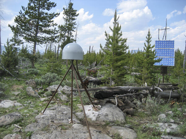
GPS station P714 in Panther Meadow, Yellowstone National Park
GPS station P714 in Panther Meadow, Yellowstone National ParkGPS station P714, located in Panther Meadow south of Mammoth Hot Springs in Yellowstone National Park. Photo by EarthScope Consortium, June 2008.
GPS station P714 in Panther Meadow, Yellowstone National Park
GPS station P714 in Panther Meadow, Yellowstone National ParkGPS station P714, located in Panther Meadow south of Mammoth Hot Springs in Yellowstone National Park. Photo by EarthScope Consortium, June 2008.

Strike-slip earthquake focal mechanism
Left hand plot shows a focal mechanism from an earthquake where the fault is horizontal (red line), and the motion is right-lateral strike skip. The initial direction of wave motion (either back toward the source or away from the source is shown by the arrows. Right hand plot shows the associated beachball diagram, with compressional (“C”) and tensional
Left hand plot shows a focal mechanism from an earthquake where the fault is horizontal (red line), and the motion is right-lateral strike skip. The initial direction of wave motion (either back toward the source or away from the source is shown by the arrows. Right hand plot shows the associated beachball diagram, with compressional (“C”) and tensional
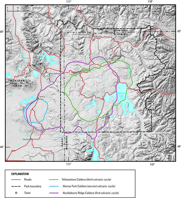
Digital elevation model of Yellowstone National Park and vicinity
Digital elevation model of Yellowstone National Park and vicinityDigital elevation model of Yellowstone National Park and vicinity, showing the location of the calderas formed during each of Yellowstone’s three most recent volcanic cycles. The youngest caldera-forming eruption produced Yellowstone Caldera (green line), located within Yellowstone National Park.

Contact between Huckleberry Ridge Tuff ignimbrite members B and C
Contact between Huckleberry Ridge Tuff ignimbrite members B and CThe contact (red arrow) between Huckleberry Ridge Tuff ignimbrite members B and C is marked by a time break of probably years to a few decades.
Contact between Huckleberry Ridge Tuff ignimbrite members B and C
Contact between Huckleberry Ridge Tuff ignimbrite members B and CThe contact (red arrow) between Huckleberry Ridge Tuff ignimbrite members B and C is marked by a time break of probably years to a few decades.

Southern tip of the Lemhi Range, eastern Snake River Plain. showing the wall of the Blue Creek caldera
Southern tip of the Lemhi Range, eastern Snake River Plain. showing the wall of the Blue Creek calderaSouthern tip of the Lemhi Range on the northeastern margin of the eastern Snake River Plain showing the caldera wall of the 6.27 million year old Blue Creek caldera, in the Heise volcanic field. Also shown are other units from the Heise volcanic field including the Kilgore Tuff and the Blacktail Creek Tuff. In the foreground is the much thicker sequence

Eruption of Daisy Geyser, Yellowstone National Park
Eruption of Daisy Geyser, Yellowstone National ParkAn eruption of Daisy Geyser in the Upper Geyser Basin of Yellowstone National Park. The geyser erupts boiling water at about 93 °C (200 °F). Photo by Shaul Hurwitz on April 12, 2007.
Eruption of Daisy Geyser, Yellowstone National Park
Eruption of Daisy Geyser, Yellowstone National ParkAn eruption of Daisy Geyser in the Upper Geyser Basin of Yellowstone National Park. The geyser erupts boiling water at about 93 °C (200 °F). Photo by Shaul Hurwitz on April 12, 2007.
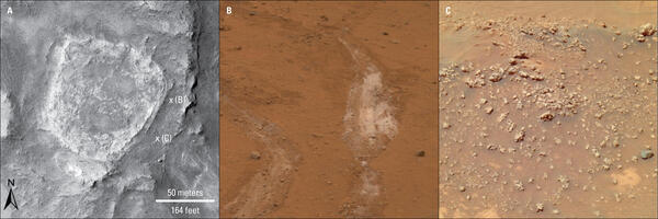
Hydrothermal deposits on Mars
Hydrothermal deposits on Mars. (A) This image was acquired by the Mars Reconnaissance Orbiter's High Resolution Imaging Science Experiment camera on November 22, 2006. It shows a bright plateau of layered rocks about 90 meters (98 yards) across called, “Home Plate.” NASA image: PSP_001513_1655_red; Image Credit: NASA/JPL-Caltech/Univ. of Arizona.
Hydrothermal deposits on Mars. (A) This image was acquired by the Mars Reconnaissance Orbiter's High Resolution Imaging Science Experiment camera on November 22, 2006. It shows a bright plateau of layered rocks about 90 meters (98 yards) across called, “Home Plate.” NASA image: PSP_001513_1655_red; Image Credit: NASA/JPL-Caltech/Univ. of Arizona.

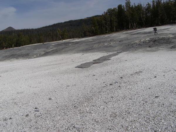
Air photo showing newly thermal areas on Mallard Lake resurgent dome
Air photo showing newly thermal areas on Mallard Lake resurgent domeNational Agriculture Imagery Program natural-color image from September 9, 2006, showing newly mapped thermal areas (outlined in yellow) on the north side of the Mallard Lake resurgent dome.

Guardian Geyser and Norris Geyser Basin, Yellowstone National Park
Guardian Geyser and Norris Geyser Basin, Yellowstone National ParkGuardian Geyser and Norris Geyser Basin, Yellowstone National Park.
Guardian Geyser and Norris Geyser Basin, Yellowstone National Park
Guardian Geyser and Norris Geyser Basin, Yellowstone National ParkGuardian Geyser and Norris Geyser Basin, Yellowstone National Park.

Excelsior Geyser and Grand Prismatic Spring, Yellowstone
Excelsior Geyser and Grand Prismatic Spring, YellowstoneAerial view of Excelsior Geyser (in the foreground) and Grand Prismatic Spring in Yellowstone’s Midway Geyser Basin. The colors around the thermal features are locations of different thermophile communities. These thermophiles fix carbon, both from the atmosphere and from the hot water. Credit Jim Peaco; June 22, 2006; Catalog #20386d; Original #IT8M4075

Old Faithful in eruption
Old Faithful Geyser in eruption. Under Yellowstone Research Permit YELL-SCI-8030, 13 mineralized wood specimens were collected from the geyser mound. The dates of the mineralized wood samples imply that such eruptions did not take place for over a century between the mid-13th to mid-14th centuries.
Old Faithful Geyser in eruption. Under Yellowstone Research Permit YELL-SCI-8030, 13 mineralized wood specimens were collected from the geyser mound. The dates of the mineralized wood samples imply that such eruptions did not take place for over a century between the mid-13th to mid-14th centuries.

Rangers attempting to clean trash out of Morning Glory Pool in 1975.
Rangers attempting to clean trash out of Morning Glory Pool in 1975.Rangers attempting to clean trash out of Morning Glory Pool in September 1975. National Park Service photograph Dan Ing.
Rangers attempting to clean trash out of Morning Glory Pool in 1975.
Rangers attempting to clean trash out of Morning Glory Pool in 1975.Rangers attempting to clean trash out of Morning Glory Pool in September 1975. National Park Service photograph Dan Ing.