
MD-DE-DC WSC Capabilities Sites
There's a lot of talent at the Maryland, Delaware, Washington, DC Water Science Center!
Explore the MD-DE-DC Water Science Center's expertise and capabilities. We work with federal, state, and local governments, universities, and non-profits on water issues.
Whether you need a streamgage to monitor a local waterway, a long-term study about a watershed, or a pertinent hydrologic question that needs answering, reach out to us and we can work with you.
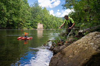
The Surface Water Team monitors stage, streamflow, and precipitation at locations in Maryland, Delaware, the District of Columbia, and beyond, providing water data vital for the protection of life and property, and supporting investigative research that describes and improves our region's understanding of extreme hydrologic events, including droughts, flood hazards, and coastal or bay storm surge and inundation.
The MD-DE-DC Water Science Center measures, analyzes, and predicts the water quality of surface water and groundwater. We collect and analyze automated continuous data and collect water samples for lab analysis. These data help us detect, quantify, and explain changes to water quality over time, understand how natural conditions and human activities affect water quality, and predict water quality in unsampled areas and into the future.
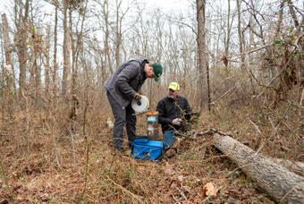
The MD-DE-DC groundwater program studies groundwater resources across the region through groundwater monitoring and in-depth studies. Our monitoring and research address groundwater flow, availability, age, water supply and use, water resource modeling, and contaminant fate and transport.
Contaminant Fate & Biroremediation
The Contaminant Fate and Bioremediation (FAB) team researches the transport, fate, and degradation of organic and inorganic contaminants in groundwater, surface water, water treatment systems, and wetlands using innovative and proven methods.
We have expertise in PFAS, chlorinated solvents, polychlorinated biphenyls, nitroaromatics, metals, nutrients and trace organic compounds.

The Geomorphology Team studies sediment movement in streams and rivers, aquatic habitats, and how flooding shapes waterways. We work with cooperators in federal, state, and local government to meet their needs. The team’s innovative approaches include hydraulic flow modeling, sediment source tracking, GIS-based morphological analyses, GNSS land surveys, and lidar analyses.
In Maryland, public supply water is delivered to users for domestic, commercial, and industrial purposes. Most is used for public services, such as public pools, parks, firefighting, water and wastewater treatment, and municipal buildings, and some is unaccounted for because of leaks, flushing, tower maintenance, and other system losses. 5.7 million Marylanders get their water from the public supply.
Coding & Statistical Data Science
The MD-DE-DC WSC has long since been a leader in the fields of Coding and Statistical Data Science. Some of the most promising talent in water science is currently based here. From the application and customization of statistical applications to developing modules in-house, making sense of large datasets by applying various modeling and visualization techniques to demonstrate theories.

The Water Resources Mission Area creates a wide variety of spatial products from GIS datasets, online mappers and decision-support tools, data visualizations, and traditional static maps. Some of the most complex and dynamic mapping in the USGS is directly linked to the talented geographers and spatial analysts that lend their expertise to projects like SPARROW, the National Hydrography Dataset, StreamStats, and the National Map. Data sets that populate the metadata sheets attached to these applications are lengthy and reliable, created by dedicated staff with an impeccable attention to detail.
Our labs assure reliability, reproducibility, and high quality of its data and information through adherence to USGS Fundamental Science Practices for publications. The use of comprehensive internal and external QA/QC processes to monitor method and analyst performance insure that our labs meet their commitment to publish high quality data of known and documented quality. External, independent oversight is provided by the USGS Branch of Quality Services as our labs are inspected by USGS qualified safety professionals.

The USGS is at the forefront of devising new techniques and computer software to solve practical problems in the study of water resources. Predictive models are needed to make informed decisions in many emerging areas related to the effects of water resources development. New models and methods enhance all USGS water programs. State and local governments as well as scientists and engineers in the private sector regularly use USGS models as an integral part of their work.
Other Areas of Expertise in the MD-DE-DC Water Science Center
The MD-DE-DC Water Science Center has developed extensive capabilities for monitoring and predicting harmful algal blooms (HABs). Our team has designed a carefully characterized SI-traceable hyperspectral microscope system to identify cyanobacteria and other algal taxa, supporting both satellite and field-based remote sensing research.
Water North Atlantic-Appalachian AI/ML Capabilities
Artificial Intelligence (AI) and Machine Learning (ML) includes a broad suite of flexible data-driven empirical approaches to perform tasks that are difficult to implement using conventional methods. AI and ML harness the power of computing resources to evaluate the underlying patterns and relationships within a dataset without explicit instructions.
The North Atlantic-Appalachian AI/ML Capability Team is comprised of staff with a wide variety of scientific backgrounds who are united by the desire to improve how data is collected and interpreted using AI and ML. As AI/ML is a rapidly changing and evolving field of data science, the capability team is a resource for sharing information, connecting problems with expert knowledge, and lowering the barriers for entry into applying AI/ML to solve earth science problems.
Northeast Region Urban Landscapes Capabilities Team
A resource to assist the Region and its Science Centers for developing regional science programs that provide technical support on impacts of urban development on water resources and ecosystems. Objectives include:
• Build expertise to help communities understand their natural resources and effects of urbanization
• Develop expertise in the effects of climate change and natural disasters on urban waters and ecology
• Interface with other Federal agencies
• Create a technical vision for urban waters science
• Support the Urban Waters Federal Partnership
Northeast Region Coastal Science Capabilities Team
Advancing the Northeast Region as a leader in coastal-science programs, including:
• Linking Flood Inundation Mapping (FIM) in riverine and coastal regions
• Major coastal flood, surge, and wave response, including rapid deployment and post-flood documentation activities
• Coastal erosion hazards and coastal processes and risk
• Documenting/understanding effects of coastal storms and flooding on coastal landscapes and ecosystems
• Linking surge, wave, tide, and river runoff for comprehensive coastal, sediment transport, hydrodynamic, and oceanographic modeling
Northeast Region Flood Science Capabilities Team
Advancing the Northeast Region as a leader in flood-science and decision support programs. The Team will be a resource to assist the Region and its Science Centers to develop and maintain flood programs. Objectives include:
• Flood Inundation Mapping (FIM) and flood vulnerability modeling
• Major flood response, including rapid deployment and post-flood activities
• Fluvial erosion hazards (FEH)
• Effects of floods on ecosystems
• Statistical hydrology and flood prediction in a future of non-stationarity measurements of discharge
• Streamgage-network evaluation