
Cheryl Dieter
Cheryl is a hydrologist at the U.S. Geological Survey, Maryland-Delaware-DC Water Science Center. Her current work is focussed on water-use data and research in the United States. She is currently working on projects to identify gaps in water-use data throughout the U.S., national water-use models, and water use in MD, DE, and DC.
Science and Products

Accessing Water Use Data
The USGS provides historic and recent water use data for the United States including the District of Columbia, Puerto Rico, and the U.S. Virgin Islands. This page provides an up-to-date guide to accessing, downloading, and using USGS water use data.

Water Use in the United States
Since 1950, the USGS has regularly produced nationwide water‑use data, creating one of the most comprehensive pictures of how water is used across the United States. Building on this rich historical record, these data give water managers a critical foundation to evaluate long‑term trends, plan strategically, and identify and quantify water availability so they can design more adaptive, resilient...

Withdrawals for Bottled Water
USGS is compiling data on locations and volumes of water withdrawals for bottled water production and learning how, when, and where bottled water withdrawals result in changes to groundwater levels, spring flows, and water quality.

Anacostia Water Quality Monitoring Project
The broad goal of the study is to significantly expand data collection at the Northeast Branch Anacostia and Northwest Branch Anacostia to include water-quality sampling and analysis for a wide suite of natural and anthropogenic constituents (nutrients, sediment, metals, bacteria, and organics such as PCBs and PAHs). MD-DE-DC WSC Project #LF00BK4

Anacostia Water Quality Monitoring Project
The broad goal of the study is to significantly expand data collection at the Northeast Branch Anacostia and Northwest Branch Anacostia to include water-quality sampling and analysis for a wide suite of natural and anthropogenic constituents (nutrients, sediment, metals, bacteria, and organics such as PCB (Polychlorinated Biphenyls) and PAH (Polycyclic aromatic hydrocarbons).

Water Use & Water Supply Capabilities at MD-DE-DC
The MD-DE-DC WSC works with state and local agencies to collect, estimate, review, and compile water use information. Data are used in USGS groundwater and watershed models, and other USGS studies. The data are also compiled and incorporated into the USGS national estimates of water-use. WSC staff currently participate in various national water use projects focused on improving water use estimates...
Changes in Water Use Categories
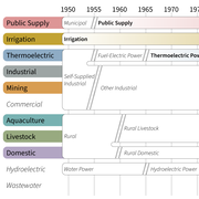
Water use terminology in the series of USGS Water Use Circulars, first published for the year 1950, has changed over time. Some categories were renamed but retained essentially the same definition, while other changes split existing categories or shifted components of one category to another.

Hydrogeology and Groundwater Quality of the Anacostia River Watershed
The Anacostia River has been subjected to dredging, filling, contamination, and other human influences for over 200 years. The result of these activities is that the river has been seriously degraded from its natural state. Many groups have been working to reduce the effects of environmental degradation on the water quality and living resources of the Anacostia River, primarily by focusing on...
Science and Products
Accessing Water Use Data
The USGS provides historic and recent water use data for the United States including the District of Columbia, Puerto Rico, and the U.S. Virgin Islands. This page provides an up-to-date guide to accessing, downloading, and using USGS water use data.
Water Use in the United States
Since 1950, the USGS has regularly produced nationwide water‑use data, creating one of the most comprehensive pictures of how water is used across the United States. Building on this rich historical record, these data give water managers a critical foundation to evaluate long‑term trends, plan strategically, and identify and quantify water availability so they can design more adaptive, resilient...
Withdrawals for Bottled Water
USGS is compiling data on locations and volumes of water withdrawals for bottled water production and learning how, when, and where bottled water withdrawals result in changes to groundwater levels, spring flows, and water quality.
Anacostia Water Quality Monitoring Project
The broad goal of the study is to significantly expand data collection at the Northeast Branch Anacostia and Northwest Branch Anacostia to include water-quality sampling and analysis for a wide suite of natural and anthropogenic constituents (nutrients, sediment, metals, bacteria, and organics such as PCBs and PAHs). MD-DE-DC WSC Project #LF00BK4
Anacostia Water Quality Monitoring Project
The broad goal of the study is to significantly expand data collection at the Northeast Branch Anacostia and Northwest Branch Anacostia to include water-quality sampling and analysis for a wide suite of natural and anthropogenic constituents (nutrients, sediment, metals, bacteria, and organics such as PCB (Polychlorinated Biphenyls) and PAH (Polycyclic aromatic hydrocarbons).
Water Use & Water Supply Capabilities at MD-DE-DC
The MD-DE-DC WSC works with state and local agencies to collect, estimate, review, and compile water use information. Data are used in USGS groundwater and watershed models, and other USGS studies. The data are also compiled and incorporated into the USGS national estimates of water-use. WSC staff currently participate in various national water use projects focused on improving water use estimates...
Changes in Water Use Categories
Water use terminology in the series of USGS Water Use Circulars, first published for the year 1950, has changed over time. Some categories were renamed but retained essentially the same definition, while other changes split existing categories or shifted components of one category to another.
Hydrogeology and Groundwater Quality of the Anacostia River Watershed
The Anacostia River has been subjected to dredging, filling, contamination, and other human influences for over 200 years. The result of these activities is that the river has been seriously degraded from its natural state. Many groups have been working to reduce the effects of environmental degradation on the water quality and living resources of the Anacostia River, primarily by focusing on...