
Subsea Permafrost and Associated Methane Hydrate on the U.S. Arctic Ocean Margin
A new publication by USGS and BOEM provides the most complete information to date about the seaward extent of remaining subsea permafrost and possible relict gas hydrate beneath the U.S. Beaufort Sea margin at the edge of the Arctic Ocean.
This article is part of the April 2017 issue of the Sound Waves newsletter.
A collaboration between USGS Coastal and Marine Geology Program researchers and Bruce Herman, now retired from the Bureau of Ocean Energy Management (BOEM) in Anchorage, Alaska, has produced the most complete information to date about the seaward extent of remaining subsea permafrost and possible relict gas hydrate beneath the U.S. Beaufort Sea margin at the edge of the Arctic Ocean. Using industry seismic reflection data and legacy borehole logs, the recent publications provide critical insights about the contemporary state of subsea permafrost and establish a baseline for tracking continued degradation of the permafrost as the oceans warm.
Permafrost, which is ground that has been at temperatures colder than 32°F (0°C) for more than two years, forms when average air temperatures are cold enough to cause sustained freezing of water trapped in sediments. On the Alaskan North Slope, permafrost that retains ice in sediment pore spaces (ice-bearing permafrost) is more than 1800 feet (550 meters) thick near Prudhoe Bay, based on studies led by USGS geologist Timothy Collett in the 1980s. Most of the continuous permafrost that remains at high northern latitudes in North America and Siberia formed during Ice Ages (global cooling events) in the late Pleistocene (between 2.6 million years ago and 11,700 years ago).

Despite its name, subsea permafrost does not form under the ocean. Instead, subsea permafrost refers to permafrost that formed on land and that was subsequently inundated as sea level rose up to 390 feet (120 meters) starting ~18,000 years ago. On an annual basis, Arctic Ocean coastal waters are warmer than ambient air temperatures by at least 18°F (10°C), meaning that permafrost usually starts to thaw once flooded. The contemporary distribution of subsea permafrost beneath an Arctic Ocean continental shelf has implications for the initial state of the permafrost, the timing of sea-level rise, and the intensity of millennial-scale warming.

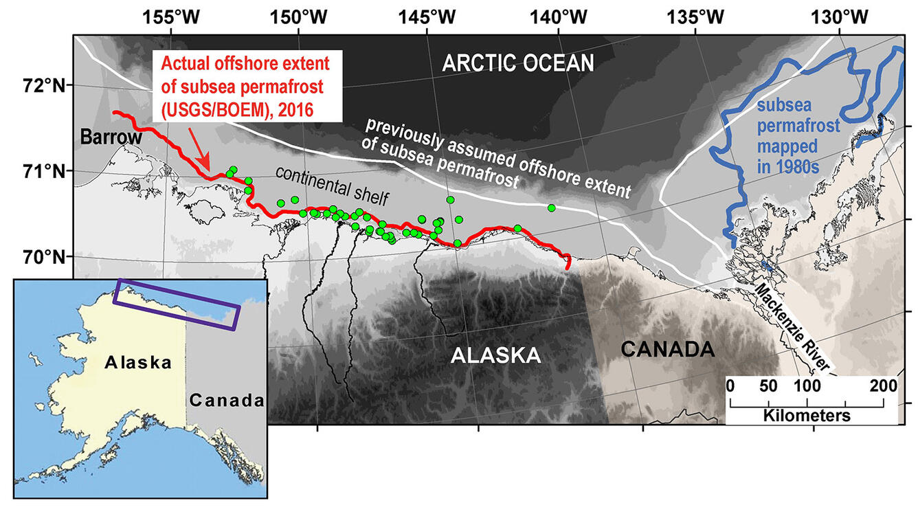
The new research challenges long-held assumptions about the offshore extent of subsea permafrost on the U.S. Arctic Ocean continental margin. Past maps have placed the seaward extent of subsea permafrost at the approximate edge of the continental shelf, in water depths of about 330 feet (100 meters). Based on the analysis of geophysical data sets, USGS and BOEM researchers conclude that most of the remaining subsea permafrost on the U.S. Arctic Ocean margin lies close to the present-day shoreline and in water less than 66 feet (20 meters) deep.
Aimee Devaris, the USGS Regional Director for the Alaska Region, notes that, “These collaborative studies have been effective in advancing our understanding of the present and future state of the Arctic Ocean on the Alaskan margin. The work is useful for the U.S. government, as well as being relevant internationally to the research interests of Arctic Council countries.”
The limited extent of subsea permafrost on the U.S. margin contrasts with much better preservation of such permafrost on the Canadian part of the margin. Recent research on the offshore extent of subsea permafrost on the Kara Sea margin is more consistent with the findings in the U.S. Arctic Ocean. The reasons for different patterns of subsea permafrost preservation on Arctic Ocean margins are a topic of active research. The persistence of subsea permafrost on the Canadian Beaufort margin compared to the U.S. Beaufort Sea and Kara Sea margins may reflect the development of thicker or more widely distributed permafrost offshore Canada at the Last Glacial Maximum (~18,000 years ago), slower inundation during sea-level rise since that time, the effect of freshwater discharge from the Mackenzie River, or other processes.
Subsea permafrost degradation also has implications for the potential release of methane from the seafloor into the ocean and/or atmosphere. Gas hydrate, an icelike form of water and concentrated gas that is stable at low temperatures and moderate pressures, often occurs within and beneath permafrost. Methane is the most common gas sequestered in hydrate deposits, and sediment warming that leads to permafrost thaw may also cause the breakdown of gas hydrate and the release of methane. Even when no gas hydrate is present, carbon that has long been frozen in sediments may be transformed into methane by microbes after permafrost thaws. Nearly 99 percent of global gas hydrate deposits outside of Antarctica occur in deep water settings, but the remaining fraction is associated with permafrost (including subsea permafrost) at high northern latitudes.
In a recent USGS-led review paper, Arctic Ocean continental shelf sediments that presently host subsea permafrost were identified as one of the few gas hydrate settings in which long-term (millennial-scale) climate change processes could be driving contemporary breakdown of the methane hydrate. Methane released at the seafloor is often transformed into carbon dioxide due to microbial activity in the water column, a process that makes ocean waters more acidic. Some fraction of methane may also travel through the water column and reach the atmosphere on shallow continental shelves. Methane is a potent greenhouse gas, and the escape of methane to the atmosphere can exacerbate global warming.
The recently published subsea permafrost papers show that relict gas hydrate that originally formed in or beneath permafrost may still be present on the east-central part of the U.S. Arctic Ocean continental shelf. When these new findings about relict hydrates are combined with data collected on USGS Gas Hydrates Project field expeditions that acquired geophysical and geochemical data on the U.S. Beaufort continental shelf, it is clear that several factors control the distribution of different populations of methane with depth below the seafloor and with distance from the shoreline.
The recently completed studies use all the publicly available seismic and borehole logging data to constrain subsea permafrost distribution beneath the U.S. Arctic Ocean continental shelf. To develop more detailed maps of subsea permafrost and relict gas hydrate deposits will require the acquisition of new data or access to privately held datasets. Recent surveys conducted by the Scripps Institute of Oceanography use electrical methods to infer the distribution of frozen sea floor sediments offshore Prudhoe Bay, Alaska, and represent an important first step in acquiring data to complement the USGS and BOEM studies.
This research was partially supported by USGS-DOE Interagency agreements DE-FE0023495 and DE-FE0002911, by a 2010-2012 DOE NETL/NRC Methane Hydrate Postdoctoral Fellowship to L.B. under DE-FC26-05NT42248, and by BOEM.
The full citations for the papers are:
Brothers, L.L., Herman, B.M., Hart, P.E., and Ruppel, C.D., 2016, Subsea ice-bearing permafrost on the U.S. Beaufort Margin—1. Minimum seaward extent defined from multichannel seismic reflection data: Geochemistry, Geophysics, Geosystems, 17, 4354–4365, doi:10.1002/2016GC006584.
Ruppel, C.D., Herman, B.M., Brothers, L.L., and Hart, P.E., 2016, Subsea ice-bearing permafrost on the U.S. Beaufort Margin—2. Borehole constraints: Geochemistry, Geophysics, Geosystems, 17, 4333–4353, doi:10.1002/2016GC006582.
Ruppel, C.D., and Kessler, J.D., 2017, The interaction of climate change and methane hydrates: Reviews of Geophysics, 55, 126–168, doi:10.1002/2016RG000534.
Brothers, L.L., Hart, P.E., and Ruppel, C.D., 2012, Minimum distribution of subsea ice-bearing permafrost on the U.S. Beaufort Sea continental shelf: Geophysical Research Letters, 39, L15501, doi:10.1029/2012GL052222.