U.S. flag

An official website of the United States government

Images

Browse images from a wide range of science topics covered by USGS. All items in this gallery are considered public domain unless otherwise noted.

Filter Total Items: 1610
Person in a blue jacket working at a weather station in the snow with mountains in the background
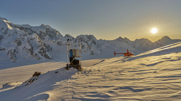
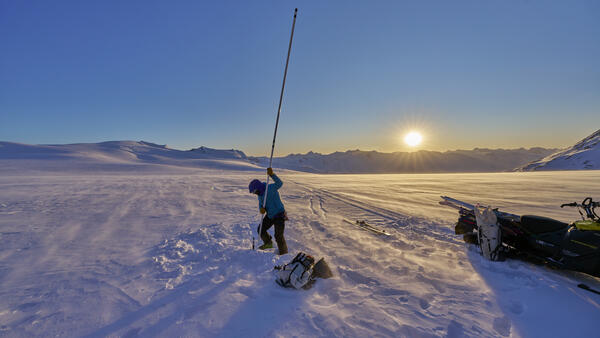
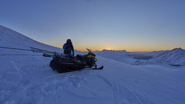
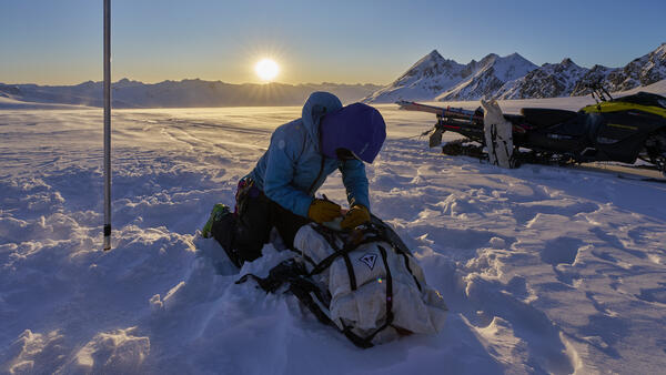
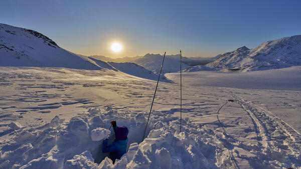
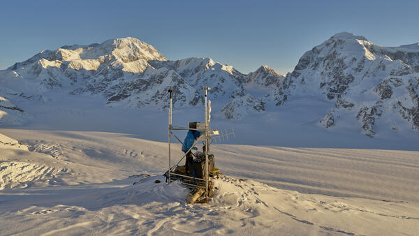
Installing a camera at the Mt. Foraker weather station in Denali National Park

Zan Frederick (USGS) installing a camera on the Mt. Foraker weather station, located on the southeast ridge at 7,826'. Mt. McKinley (20,320 ft) and Mt. Hunter (14,573 ft) are in the background. This site is a collaboration between USGS, Denali National Park, and the National Park Service Inventory and Monitoring program.

Zan Frederick (USGS) installing a camera on the Mt. Foraker weather station, located on the southeast ridge at 7,826'. Mt. McKinley (20,320 ft) and Mt. Hunter (14,573 ft) are in the background. This site is a collaboration between USGS, Denali National Park, and the National Park Service Inventory and Monitoring program.

Person in blue jacket at a weather station on snow with the sunshine, mountains, and a red helicopter in the background
Camera installation at the Mt. Foraker weather station in Denali National Park

Zan Frederick (USGS) installing a camera on the Mt. Foraker weather station, located on the southeast ridge at 7,826'. This site is a collaboration between USGS, Denali National Park, and the National Park Service Inventory and Monitoring program. The camera transmits low-latency images once daily in winter and hourly during the busy summer season.

Zan Frederick (USGS) installing a camera on the Mt. Foraker weather station, located on the southeast ridge at 7,826'. This site is a collaboration between USGS, Denali National Park, and the National Park Service Inventory and Monitoring program. The camera transmits low-latency images once daily in winter and hourly during the busy summer season.

Black outline of Alaska with purple, orange, and green circles with numbers and a bar plot corresponding to the colors
Bar plot showing the percentage of Chinook salmon with evidence of heat stress across Alaska

Bar plot showing the percentage of Chinook salmon with evidence of heat stress in each group based on the heat shock protein 70 (HSP70) protein concentration data. Map indicates sample collection locations. Sample groups are arranged by region from north to south: Norton Sound (purple), Yukon (orange), and Kuskokwim (green).

Bar plot showing the percentage of Chinook salmon with evidence of heat stress in each group based on the heat shock protein 70 (HSP70) protein concentration data. Map indicates sample collection locations. Sample groups are arranged by region from north to south: Norton Sound (purple), Yukon (orange), and Kuskokwim (green).

Person on skis standing on a glacier.
Zan Frederick (USGS) on upper Wolverine Glacier

Wind driven snow transport across the glacier surface near site Y on upper Wolverine Glacier.

Snow pit on glacier with sun setting in background.
Zan Frederick (USGS) digging a snowpit

At site S on Wolverine Glacier. Zan digs down to the previous summer surface to see where the ablation stake intersects the melt surface. This will allow scientists to calculate the ablation (melt) from the previous summer.

At site S on Wolverine Glacier. Zan digs down to the previous summer surface to see where the ablation stake intersects the melt surface. This will allow scientists to calculate the ablation (melt) from the previous summer.

Person with a backpack skiing down a glacier.
Zan Frederick (USGS) skiing down Wolverine Glacier to Paradise Lake

The wind was too strong for a helicopter to land, therefore, glaciologist skied down Wolverine Glacier to Paradise Lake.

Person holding a lake stake vertically on a glacier.
Zan Frederick (USGS) extending a mass balance stake

Extending a mass balance stake at site EC on upper wolverine glacier. These stakes are used to measure snow accumulation and ablation (melt). 

Extending a mass balance stake at site EC on upper wolverine glacier. These stakes are used to measure snow accumulation and ablation (melt). 

Person standing near a snowmachine on a glacier.
Zan Frederick (USGS) packing gear at sunset on Wolverine Glacier
Landsat image of Columbia Glacier in 2025.
Columbia Glacier 2025

Landsat 9 image of Columbia Glacier, Alaska on Sept. 17, 2025.

Landsat 9 image of Columbia Glacier, Alaska on Sept. 17, 2025.

Black and white three-ring binders with content labels.
Shelf of legacy seabird data

A shelf full of legacy data collected on seabirds in Cook Inlet and Glacier Bay, Alaska.

White and brown carboard boxes stacked on top of each other.
Physical data ready for archive

Alaska Science Center Data Management staff organize, scan, and digitally archive physical data. Once published as part of a data release, the physical data are organized and placed into banker boxes, labeled with pertinent information, such as the data release DOI, and moved to a secure location.

Alaska Science Center Data Management staff organize, scan, and digitally archive physical data. Once published as part of a data release, the physical data are organized and placed into banker boxes, labeled with pertinent information, such as the data release DOI, and moved to a secure location.

Brown vegetation and a small stream.
Acidic waters kill and blacken vegetation as they plunge downhill towards the Nakolikurok Creek

Orange streams are increasingly common in the Brooks Range of northern Alaska. The orange stream color reflects oxidized iron, but also often indicates elevated heavy metal concentrations. Our ongoing study aims to document these occurrences and the timing of their onset.

Pale orange river entering clear blue river.
An orange tributary of the Kugururok River in Alaska's Noatak National Preserve

Orange streams are increasingly common in the Brooks Range of northern Alaska. The orange stream color reflects oxidized iron, but also often indicates elevated heavy metal concentrations. Our ongoing study aims to document these occurrences and the timing of their onset.

Orange streams are increasingly common in the Brooks Range of northern Alaska. The orange stream color reflects oxidized iron, but also often indicates elevated heavy metal concentrations. Our ongoing study aims to document these occurrences and the timing of their onset.

A pale orange and clear blue river mixing.
Mixing of an orange tributary and Kugururok River, Noatak National Preserve, Alaska

Orange streams are increasingly common in the Brooks Range of northern Alaska. The orange stream color reflects oxidized iron, but also often indicates elevated heavy metal concentrations. Our ongoing study aims to document these occurrences and the timing of their onset.

Orange streams are increasingly common in the Brooks Range of northern Alaska. The orange stream color reflects oxidized iron, but also often indicates elevated heavy metal concentrations. Our ongoing study aims to document these occurrences and the timing of their onset.

pale orange river flowing into a clear blue river.
An orange tributary of the Kugururok River in Noatak National Preserve, Alaska

Orange streams are increasingly common in the Brooks Range of northern Alaska. The orange stream color reflects oxidized iron, but also often indicates elevated heavy metal concentrations. Our ongoing study aims to document these occurrences and the timing of their onset.

Orange streams are increasingly common in the Brooks Range of northern Alaska. The orange stream color reflects oxidized iron, but also often indicates elevated heavy metal concentrations. Our ongoing study aims to document these occurrences and the timing of their onset.

Black vegetation surrounding a creek.
An acid seep on the Nakolikurok Creek

Orange streams are increasingly common in the Brooks Range of northern Alaska. The orange stream color reflects oxidized iron, but also often indicates elevated heavy metal concentrations. Our ongoing study aims to document these occurrences and the timing of their onset.

Orange streams are increasingly common in the Brooks Range of northern Alaska. The orange stream color reflects oxidized iron, but also often indicates elevated heavy metal concentrations. Our ongoing study aims to document these occurrences and the timing of their onset.

Pale orange creek flowing into clear blue river.
Orange waters mixing in to the mainstem of the Kugururok River

Orange streams are increasingly common in the Brooks Range of northern Alaska. The orange stream color reflects oxidized iron, but also often indicates elevated heavy metal concentrations. Our ongoing study aims to document these occurrences and the timing of their onset.

Orange streams are increasingly common in the Brooks Range of northern Alaska. The orange stream color reflects oxidized iron, but also often indicates elevated heavy metal concentrations. Our ongoing study aims to document these occurrences and the timing of their onset.

Bear tracks in an orange-stained river.
Bear tracks in an orange tributary of the Kugururok River, Noatak National Preserve, Alaska

Orange streams are increasingly common in the Brooks Range of northern Alaska. The orange stream color reflects oxidized iron, but also often indicates elevated heavy metal concentrations. Our ongoing study aims to document these occurrences and the timing of their onset.

Orange streams are increasingly common in the Brooks Range of northern Alaska. The orange stream color reflects oxidized iron, but also often indicates elevated heavy metal concentrations. Our ongoing study aims to document these occurrences and the timing of their onset.

A white net in an orange creek.
Drift net collecting samples in orange tributary of Anatok Creek, Kobuk Valley National Park, Alaska

Orange streams are increasingly common in the Brooks Range of northern Alaska. The orange stream color reflects oxidized iron, but also often indicates elevated heavy metal concentrations. Our ongoing study aims to document these occurrences and the timing of their onset.

Faint orange creek running through green brush.
Anatok Creek, Kobuk Valley National Park, Alaska

Orange streams are increasingly common in the Brooks Range of northern Alaska. The orange stream color reflects oxidized iron, but also often indicates elevated heavy metal concentrations. Our ongoing study aims to document these occurrences and the timing of their onset.

Orange streams are increasingly common in the Brooks Range of northern Alaska. The orange stream color reflects oxidized iron, but also often indicates elevated heavy metal concentrations. Our ongoing study aims to document these occurrences and the timing of their onset.

Was this page helpful?