

An IfSAR DEM image (left) is highlighting the presence of several steep-sided pingos and thaw lake basins. IfSAR data was collected for Alaska between 2012-2020.
Images
Browse images from a wide range of science topics covered by USGS. All items in this gallery are considered public domain unless otherwise noted.
Filter Total Items: 1611

Map of data contributors and primary sampling methods
Map of data contributors and primary sampling methodsThis map is showing data contributors and primary sampling methods for Alaska Forage Fish Database (AFFD).
Map of data contributors and primary sampling methods
Map of data contributors and primary sampling methodsThis map is showing data contributors and primary sampling methods for Alaska Forage Fish Database (AFFD).

Forage fish occurrence map
Map of locations within the Alaska Forage Fish Database where forage species were encountered (color). Grey points represent sites where sampling occurred, but the specific forage species was not encountered.
Map of locations within the Alaska Forage Fish Database where forage species were encountered (color). Grey points represent sites where sampling occurred, but the specific forage species was not encountered.

Weather station on Kahiltna Glacier
USGS scientist Louis Sass assesses an on-glacier weather station on the Kahiltna Glacier in Denali National Park, Alaska. This weather station is located at Kahiltna Base Camp, where climbers attempting to summit Denali begin their ascent. Sultana (Mt. Foraker) is visible in the background.
USGS scientist Louis Sass assesses an on-glacier weather station on the Kahiltna Glacier in Denali National Park, Alaska. This weather station is located at Kahiltna Base Camp, where climbers attempting to summit Denali begin their ascent. Sultana (Mt. Foraker) is visible in the background.
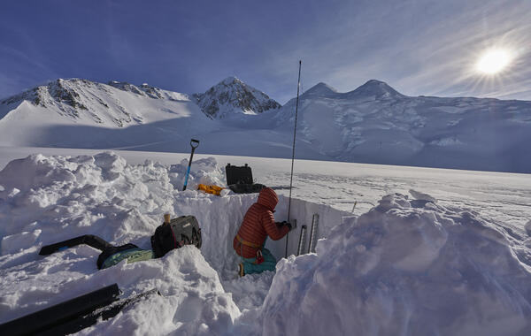
Sampling a snow pit on Kahiltna Glacier
Emily Baker (USGS) sampling a snow-pit on Kahiltna Glacier at 3,055 m (10,023 feet).
Emily Baker (USGS) sampling a snow-pit on Kahiltna Glacier at 3,055 m (10,023 feet).
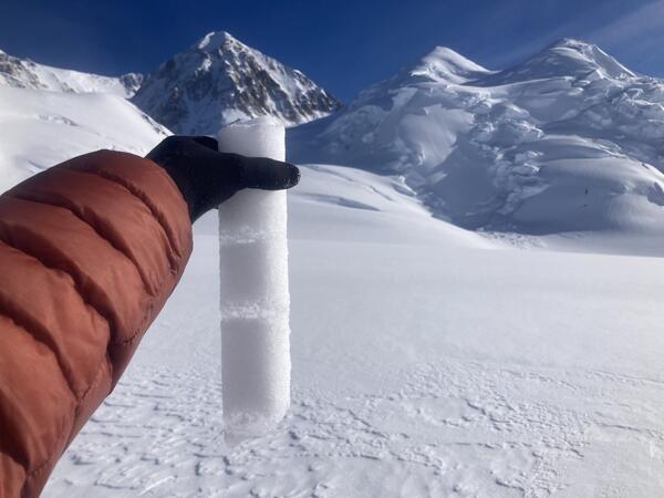
Internal accumulation layers on Kahiltna Glacier
A core section from Kahiltna Glacier at 3,055 m (10,023 feet) on September 30, 2024, showing ice layers in finegrained snow. These "internal accumulation" layers form when water from surface melt percolates into the snowpack and refreezes.
A core section from Kahiltna Glacier at 3,055 m (10,023 feet) on September 30, 2024, showing ice layers in finegrained snow. These "internal accumulation" layers form when water from surface melt percolates into the snowpack and refreezes.
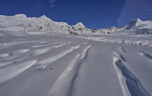
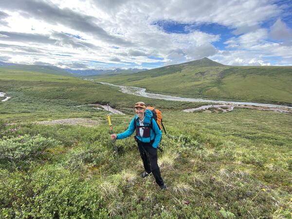
Flying over Kennicott Glacier
These are large glaciers, and even with a helicopter they make you feel very small. Here the scale of the crevasses is illustrated by the small helicopter shadow. This is typical of the complicated topography and significant relief that is common on larger glaciers in Alaska.
These are large glaciers, and even with a helicopter they make you feel very small. Here the scale of the crevasses is illustrated by the small helicopter shadow. This is typical of the complicated topography and significant relief that is common on larger glaciers in Alaska.

Drone on beach
USGS uses small uncrewed aerial systems, also known as drones for science, to survey walrus herds and carcasses on remote Alaskan beaches. The USGS visual observer, Christina Ahlstrom, keeps her eyes on the survey drone while the remote pilot prepares it to survey the walrus herd that is visible in the distance behind her on the beach.
USGS uses small uncrewed aerial systems, also known as drones for science, to survey walrus herds and carcasses on remote Alaskan beaches. The USGS visual observer, Christina Ahlstrom, keeps her eyes on the survey drone while the remote pilot prepares it to survey the walrus herd that is visible in the distance behind her on the beach.

Walrus carcasses
Aerial survey drone prepared for flight positioned on the beach near walrus calf carcasses. When sea ice retreats from large regions of the Chukchi Sea large herds of female and young walruses come to shore to rest.
Aerial survey drone prepared for flight positioned on the beach near walrus calf carcasses. When sea ice retreats from large regions of the Chukchi Sea large herds of female and young walruses come to shore to rest.
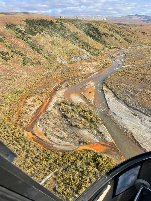
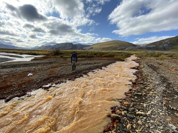
Orange staining in a side channel of the Nakolikurok Creek
Orange staining in a side channel of the Nakolikurok CreekOrange streams are increasingly common in the Brooks Range of northern Alaska. The orange stream color reflects oxidized iron, but also often indicates elevated heavy metal concentrations. Our ongoing study aims to document these occurrences and the timing of their onset.
Emergence of acidic waters from a seep in the Agashashok River Watershed
Emergence of acidic waters from a seep in the Agashashok River WatershedOrange streams are increasingly common in the Brooks Range of northern Alaska. The orange stream color reflects oxidized iron, but also often indicates elevated heavy metal concentrations. Our ongoing study aims to document these occurrences and the timing of their onset.
An orange tributary of the Igning River, Gates of the Arctic National Park and Preserve, Alaska
An orange tributary of the Igning River, Gates of the Arctic National Park and Preserve, AlaskaOrange streams are increasingly common in the Brooks Range of northern Alaska. The orange stream color reflects oxidized iron, but also often indicates elevated heavy metal concentrations. Our ongoing study aims to document these occurrences and the timing of their onset.

Signage
Sign along a wall adjacent to a parking lot in downtown Anchorage warn motorists and passersby about the hazard presented by unreinforced masonry walls.
Sign along a wall adjacent to a parking lot in downtown Anchorage warn motorists and passersby about the hazard presented by unreinforced masonry walls.

Streamflow measurement
Streamflow measurement at the U.S. Geological Survey Chester Creek streamgage. U.S. Geological Survey hydrologic technician using an acoustic Doppler current profiler to measure streamflow.
Streamflow measurement at the U.S. Geological Survey Chester Creek streamgage. U.S. Geological Survey hydrologic technician using an acoustic Doppler current profiler to measure streamflow.

A pair of Long-billed Murrelets
The photo is of two Long-billed Murrelets seen near Grewingk Glacier in Kachemak Bay, Cook Inlet, Alaska. This pair of uncommon visitors was spotted in Kachemak Bay during the annual USGS survey of seabirds and small pelagic fish in Cook Inlet.
The photo is of two Long-billed Murrelets seen near Grewingk Glacier in Kachemak Bay, Cook Inlet, Alaska. This pair of uncommon visitors was spotted in Kachemak Bay during the annual USGS survey of seabirds and small pelagic fish in Cook Inlet.
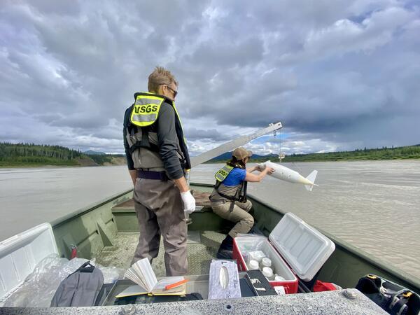
USGS staff collecting water quality samples on the Yukon River at Eagle
USGS staff collecting water quality samples on the Yukon River at EagleUSGS staff sample the Yukon River for cyanide after a heap leach failure occurred upstream at the Eagle Gold Mine in the Yukon, Canada.
USGS staff collecting water quality samples on the Yukon River at Eagle
USGS staff collecting water quality samples on the Yukon River at EagleUSGS staff sample the Yukon River for cyanide after a heap leach failure occurred upstream at the Eagle Gold Mine in the Yukon, Canada.
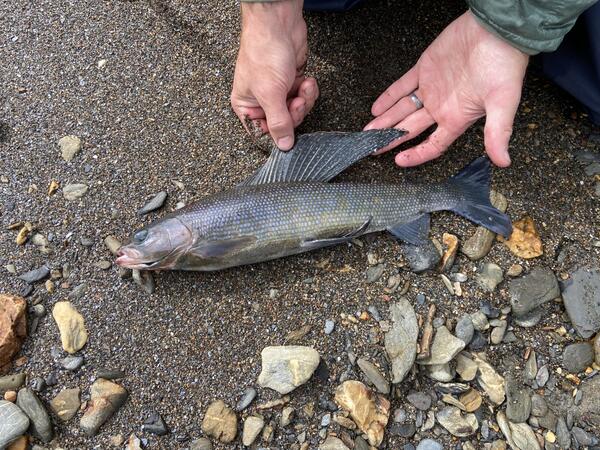
Arctic Grayling (Thymallus arctus) caught in the Nakolikuruk River near an orange tributary, Noatak National Preserve, Alaska
Arctic Grayling (Thymallus arctus) caught in the Nakolikuruk River near an orange tributary, Noatak National Preserve, AlaskaOrange streams are increasingly common in the Brooks Range of northern Alaska. The orange stream color reflects oxidized iron, but also often indicates elevated heavy metal concentrations. Our ongoing study aims to document these occurrences and the timing of their onset.
Surveying for "rusting rivers" in the Nakolikurok Creek watershed, Noatak National Preserve, Alaska
Surveying for "rusting rivers" in the Nakolikurok Creek watershed, Noatak National Preserve, AlaskaOrange streams are increasingly common in the Brooks Range of northern Alaska. The orange stream color reflects oxidized iron, but also often indicates elevated heavy metal concentrations. Our ongoing study aims to document these occurrences and the timing of their onset.

Ground temperature monitoring
A scientist is examining the cable number from a set of legacy borehole sites for permafrost ground temperature monitoring in Utqiagvik, Alaska (part of USGS research at the Naval Arctic Research Laboratory from the 1950s to 1970s).
A scientist is examining the cable number from a set of legacy borehole sites for permafrost ground temperature monitoring in Utqiagvik, Alaska (part of USGS research at the Naval Arctic Research Laboratory from the 1950s to 1970s).
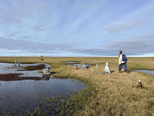
Legacy borehole site, Alaska
A scientist is walking by a set of legacy borehole sites for permafrost ground temperature monitoring in Utqiagvik, Alaska (part of USGS research at the Naval Arctic Research Laboratory from the 1950s to 1970s). Some of the wooden housings that covered these boreholes have since toppled over; others are submerged in pools of the thawing landscape.
A scientist is walking by a set of legacy borehole sites for permafrost ground temperature monitoring in Utqiagvik, Alaska (part of USGS research at the Naval Arctic Research Laboratory from the 1950s to 1970s). Some of the wooden housings that covered these boreholes have since toppled over; others are submerged in pools of the thawing landscape.

Permafrost ground temperature monitoring
A scientist is holding the cable top at a recently relocated site for permafrost ground temperature monitoring in Utqiagvik, Alaska (part of USGS research at the Naval Arctic Research Laboratory from the 1950s to 1970s).
A scientist is holding the cable top at a recently relocated site for permafrost ground temperature monitoring in Utqiagvik, Alaska (part of USGS research at the Naval Arctic Research Laboratory from the 1950s to 1970s).