
Black Brant Flock. Photo taken at Icy Cape study site. Icy Cape is part of the National Petroleum Reserve-Alaska (NPR-A) on the Arctic Coastal Plain. This was one of many study site locations of waterbird-oriented ecosystem studies in the National Petroleum Reserve-Alaska from 1974-1992.
Images
Browse images from a wide range of science topics covered by USGS. All items in this gallery are considered public domain unless otherwise noted.
Filter Total Items: 1611

Black Brant Flock, Ice Cape, Alaska
Black Brant Flock. Photo taken at Icy Cape study site. Icy Cape is part of the National Petroleum Reserve-Alaska (NPR-A) on the Arctic Coastal Plain. This was one of many study site locations of waterbird-oriented ecosystem studies in the National Petroleum Reserve-Alaska from 1974-1992.

landscape 5 of Icy Cape, Alaska
1980 photo of biologist sitting on land at Icy Cape Alaska. Icy Cape is part of the National Petroleum Reserve-Alaska (NPR-A) on the Arctic Coastal Plain. This was one of many study site locations of waterbird-oriented ecosystem studies in the National Petroleum Reserve-Alaska from 1974-1992.
1980 photo of biologist sitting on land at Icy Cape Alaska. Icy Cape is part of the National Petroleum Reserve-Alaska (NPR-A) on the Arctic Coastal Plain. This was one of many study site locations of waterbird-oriented ecosystem studies in the National Petroleum Reserve-Alaska from 1974-1992.

Long-tailed Jaeger chick, Alaska
Long-tailed Jaeger chick, Alaska. Photo taken at Icy Cape study site. Icy Cape is part of the National Petroleum Reserve-Alaska (NPR-A) on the Arctic Coastal Plain. This was one of many study site locations of waterbird-oriented ecosystem studies in the National Petroleum Reserve-Alaska from 1974-1992.
Long-tailed Jaeger chick, Alaska. Photo taken at Icy Cape study site. Icy Cape is part of the National Petroleum Reserve-Alaska (NPR-A) on the Arctic Coastal Plain. This was one of many study site locations of waterbird-oriented ecosystem studies in the National Petroleum Reserve-Alaska from 1974-1992.

Biologist measuring long-tailed Jaeger chick, Alaska
Biologist measuring long-tailed Jaeger chick, AlaskaBiologist measuring long-tailed Jaeger chick at study site at Icy Cape Alaska. Icy Cape is part of the National Petroleum Reserve-Alaska (NPR-A) on the Arctic Coastal Plain. This was one of many study site locations of waterbird-oriented ecosystem studies in the National Petroleum Reserve-Alaska from 1974-1992.

Lemming, Icy Cape, Alaska
Biologist holding lemming. Photo taken at Icy Cape study site. Icy Cape is part of the National Petroleum Reserve-Alaska (NPR-A) on the Arctic Coastal Plain. This was one of many study site locations of waterbird-oriented ecosystem studies in the National Petroleum Reserve-Alaska from 1974-1992.
Biologist holding lemming. Photo taken at Icy Cape study site. Icy Cape is part of the National Petroleum Reserve-Alaska (NPR-A) on the Arctic Coastal Plain. This was one of many study site locations of waterbird-oriented ecosystem studies in the National Petroleum Reserve-Alaska from 1974-1992.

Bairds Sandpiper nest at Point Storkersen, Alaska
Collecting habitat information at a Baird's Sandpiper nest study site at Point Storkersen on the Arctic coastal plain of Alaska. This was one of many study site locations of waterbird-oriented ecosystem studies in the National Petroleum Reserve-Alaska from 1974-1992.
Collecting habitat information at a Baird's Sandpiper nest study site at Point Storkersen on the Arctic coastal plain of Alaska. This was one of many study site locations of waterbird-oriented ecosystem studies in the National Petroleum Reserve-Alaska from 1974-1992.

Caribou on the tundra at Point Storkersen, Alaska
Caribou on the tundra at Point Storkersen on the Arctic coastal plain of Alaska. This was one of many study site locations of waterbird-oriented ecosystem studies in the National Petroleum Reserve-Alaska from 1974-1992.
Caribou on the tundra at Point Storkersen on the Arctic coastal plain of Alaska. This was one of many study site locations of waterbird-oriented ecosystem studies in the National Petroleum Reserve-Alaska from 1974-1992.

Blooming moss campion at Point Storkersen on the Arctic coastal plain of Alaska
Blooming moss campion at Point Storkersen on the Arctic coastal plain of AlaskaPhoto of moss campion flowering at Point Storkersen on the Arctic coastal plain of Alaska. Moss campion or cushion pink, is a small mountain-dwelling wildflower that is common all over the high arctic and tundra. This was one of many study site locations of waterbird-oriented ecosystem studies in the National Petroleum Reserve-Alaska from 1974-1992.

Banded Buff-breasted Sandpiper chick at Point Storkersen, Alaska
Banded Buff-breasted Sandpiper chick at Point Storkersen, AlaskaBanded Buff-breasted Sandpiper chick at Point Storkersen on the Arctic coastal plain of Alaska. This was one of many study site locations of waterbird-oriented ecosystem studies in the National Petroleum Reserve-Alaska from 1974-1992.

Scientist examining the body condition of a Buff-breasted Sandpiper chick
Scientist examining the body condition of a Buff-breasted Sandpiper chickShorebird nests and broods were monitored daily as part of a long-term study to determine reproductive success of multiple species. The tundra habitat around Pt. Storkersen supports a diversity of shorebird and waterfowl species.

Northwest Island Lake, Alaska
Northwest Island Lake located in the Teshekpuk Lake Special Management Area of the National Petroleum Reserve-Alaska (NPR-A) on the Arctic Coastal Plain. This area provides important habitat for migratory birds. This was one of many study site locations of waterbird-oriented ecosystem studies in the National Petroleum Reserve-Alaska from 1974-1992.
Northwest Island Lake located in the Teshekpuk Lake Special Management Area of the National Petroleum Reserve-Alaska (NPR-A) on the Arctic Coastal Plain. This area provides important habitat for migratory birds. This was one of many study site locations of waterbird-oriented ecosystem studies in the National Petroleum Reserve-Alaska from 1974-1992.

Arctic Foxes on the Arctic coastal plain of Alaska
Arctic Foxes on the Arctic coastal plain of AlaskaTwo Arctic Foxes at Point Storkersen on the Arctic coastal plain of Alaska. This was one of many study site locations of waterbird-oriented ecosystem studies in the National Petroleum Reserve-Alaska from 1974-1992.

A flock of waterfowl flying over Izembek Lagoon
A flock of waterfowl flying over Izembek Lagoon on the outskirts of Izembek National Wildlife Refuge on the Alaska Peninsula. Scientists observed the response of Black Brant and other geese to the disturbance of aircraft overflights during a long-term study in the 1980s.
A flock of waterfowl flying over Izembek Lagoon on the outskirts of Izembek National Wildlife Refuge on the Alaska Peninsula. Scientists observed the response of Black Brant and other geese to the disturbance of aircraft overflights during a long-term study in the 1980s.

Repeat oblique photographs of Gulkana glaciers in Alaska.
Repeat oblique photographs of Gulkana glaciers in Alaska.Repeat oblique photographs of Gulkana glaciers in Alaska. 1967, Unknown USGS photographer. 2016, L. Sass, USGS.
Repeat oblique photographs of Gulkana glaciers in Alaska.
Repeat oblique photographs of Gulkana glaciers in Alaska.Repeat oblique photographs of Gulkana glaciers in Alaska. 1967, Unknown USGS photographer. 2016, L. Sass, USGS.
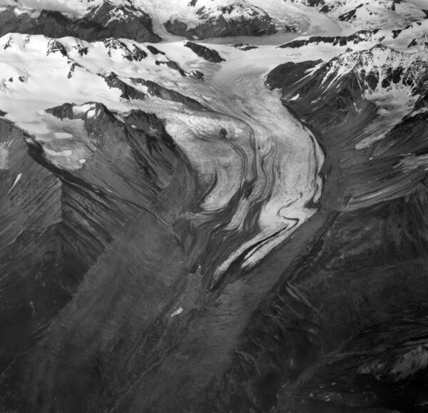
Gulkana Glacier 1967
Gulkana Glacier. Ice flowing from four tributaries unites to form the main glacier. Irregular and folded medial moraines suggest that this glacier surges, but no recent advances have been observed. In recent decades the glacier has been shrinking rapidly; note the large barren area in front of the terminus recently exposed by the melting ice.
Gulkana Glacier. Ice flowing from four tributaries unites to form the main glacier. Irregular and folded medial moraines suggest that this glacier surges, but no recent advances have been observed. In recent decades the glacier has been shrinking rapidly; note the large barren area in front of the terminus recently exposed by the melting ice.

Repeat oblique photographs of Wolverine glacier in Alaska.
Repeat oblique photographs of Wolverine glacier in Alaska.Repeat oblique photographs of Wolverine glacier in Alaska. 1966 image by unknown USGS photographer; 2015 image by L. Sass, USGS.
Repeat oblique photographs of Wolverine glacier in Alaska.
Repeat oblique photographs of Wolverine glacier in Alaska.Repeat oblique photographs of Wolverine glacier in Alaska. 1966 image by unknown USGS photographer; 2015 image by L. Sass, USGS.
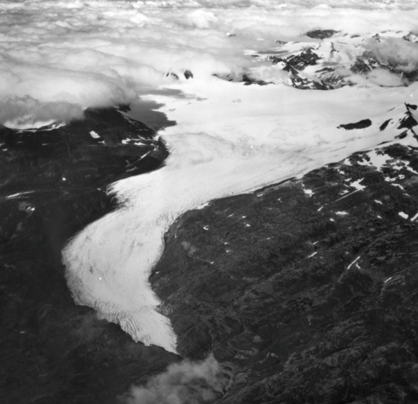
Wolverine Glacier 1966
Wolverine Glacier. The glacier heads in a broad basin but terminates in a narrow gorge. Crevasses indicate this glacier is flowing quite rapidly. Relatively little retreat in recent decades is demonstrated by the narrow areas of recently exposed bedrock along the margins of the ice. Seward district, Alaska Gulf region, Alaska. September 3, 1966.
Wolverine Glacier. The glacier heads in a broad basin but terminates in a narrow gorge. Crevasses indicate this glacier is flowing quite rapidly. Relatively little retreat in recent decades is demonstrated by the narrow areas of recently exposed bedrock along the margins of the ice. Seward district, Alaska Gulf region, Alaska. September 3, 1966.

New control tower for Anchorage International Airport
New control tower for Anchorage International AirportAlbum caption: New control tower for Anchorage International Airport, built by Federal Aviation Agency at a cost of \$850,000. One of the first of the new 0-type towers in the nation, it was operational by February, 1965. Anchorage district, Cook Inlet region, Alaska. n.d. (Photo by Federal Aviation Agency).

The village of Portage, Alaska
The village of Portage, Alaska at the head of Turnagain Arm of Cook Inlet, is flooded at high tide as a result of 6 feet of tectonic subsidence during the earthquake.
The village of Portage, Alaska at the head of Turnagain Arm of Cook Inlet, is flooded at high tide as a result of 6 feet of tectonic subsidence during the earthquake.

Two buildings on hillside
Compare the damage sustained by the Hillside apartment building on left side and the adjacent three-story wood-frame dwelling with tall chimney. In general, wood frame buildings in Anchorage sustained little damage from seismic vibrations.
Compare the damage sustained by the Hillside apartment building on left side and the adjacent three-story wood-frame dwelling with tall chimney. In general, wood frame buildings in Anchorage sustained little damage from seismic vibrations.

Government Hill elementary school
Close-up of the elementary school which was destroyed by the Government Hill landslide. Subsidence of the graben at the head of the Government Hill landslide in Anchorage tore apart an elementary school and converted the schoolyard into a jumble of fissures, scarps, and tilted and subsided blocks of broken ground.
Close-up of the elementary school which was destroyed by the Government Hill landslide. Subsidence of the graben at the head of the Government Hill landslide in Anchorage tore apart an elementary school and converted the schoolyard into a jumble of fissures, scarps, and tilted and subsided blocks of broken ground.