
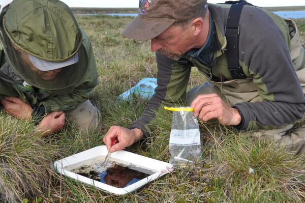
Ninespine stickleback experimental release. The addition of small-bodied ninespine stickleback to fishless thermokarst ponds provided valuable information on their ability to influence invertebrate prey. Through consumption, ninespine stickleback substantially reduced invertebrate biomass during the 6-week experiment.
Fish and aquatic habitats in Alaska support important commercial, sport, and subsistence fisheries and provide forage fish that support wildlife populations. The USGS Alaska Science Center conducts interdisciplinary research to inform local, state, federal, and international policy makers regarding conservation of fish, aquatic species, and their habitats. We work collaboratively with hydrologists, geologists and other biologists to study fish and aquatic systems in an ecosystem based framework. The goal of our current research effort is to improve our understanding of the biocomplexity, resilience, and function of aquatic ecosystems to better inform future predictions of fish and aquatic ecosystems as they respond to a changing environment.
Return to Ecosystems
- Assessing Heat Stress in Migrating Yukon River Chinook Salmon
- Nearshore Fish Surveys in the Beaufort Sea
- Sockeye Salmon Migrating at the Northern Edge of Their Distribution
- Effect of Elodea spp. on Fish Performance Mediated Through Food Web Interactions
- Hydro-Ecology of Arctic Thawing (HEAT): Ecology or Hydrology
- Primary production sources and bottom-up limitations in nearshore ecosystems
- Lake Trout Biochronologies as Long-term Climate and Productivity Indicators in Alaska Lake Ecosystems
- Ecosystem Shifts in Arctic Seas
- Condition of Forage Fish in Prince William Sound during the marine heatwave
- Arctic Lake Food Webs
- Winter Habitat of juvenile Dolly Varden in the Canning River
- Beavers Impacting Tundra Ecosystems (BITE)

Sources/Usage: Public Domain. View Media Details
Below are multimedia items associated with this project.
Filter Total Items: 100

Ninespine stickleback experimental release
Ninespine stickleback experimental release. The addition of small-bodied ninespine stickleback to fishless thermokarst ponds provided valuable information on their ability to influence invertebrate prey. Through consumption, ninespine stickleback substantially reduced invertebrate biomass during the 6-week experiment.

Tanalian Mountain and Hardenburg Bay in Lake Clark, Alaska
Reflections of Tanalian Mountain and Hardenburg Bay in Lake Clark, Alaska. Near Port Alsworth.
Reflections of Tanalian Mountain and Hardenburg Bay in Lake Clark, Alaska. Near Port Alsworth.

Ice wedge polygons on the north slope of Alaska
Ice wedge polygons near the Chipp River area on the north slope of Alaska
Ice wedge polygons near the Chipp River area on the north slope of Alaska
Sorting through invertebrates from a north slope lake of Alaska
As part of the Changing Arctic Ecosystem project, two biologists sampling invertebrates near the Chipp River area.
As part of the Changing Arctic Ecosystem project, two biologists sampling invertebrates near the Chipp River area.

A north slope camp
An enhanced photo of camp on the north slope.

Clear Montana Bill Creek flowing into volcanically silted creek
A clear Montana Bill Creek flowing into volcanically silted creek. Coho salmon are seen holding in the clear water area. Aerial surveys were done after the eruption of the Redoubt volcano to determine the condition of fish streams.
A clear Montana Bill Creek flowing into volcanically silted creek. Coho salmon are seen holding in the clear water area. Aerial surveys were done after the eruption of the Redoubt volcano to determine the condition of fish streams.

Salmon in Montana Bill Creek after the Redoubt Volcano 2009 eruption
A coho salmon holding in Montana Bill Creek after the Redoubt volcano eruption.
A coho salmon holding in Montana Bill Creek after the Redoubt volcano eruption.

Cannery Creek after the Redoubt Volcano eruption of 2009
Cannery Creek on the west side of Cook Inlet, Alaska. Aerial surveys were done after the eruption of the Redoubt volcano to determine the condition of fish streams.
Cannery Creek on the west side of Cook Inlet, Alaska. Aerial surveys were done after the eruption of the Redoubt volcano to determine the condition of fish streams.

Redoubt Volcano panorama with the Drift River Delta
A panorama of the Redoubt Volcano after the 2009 eruption and the Drift River delta in the foreground
A panorama of the Redoubt Volcano after the 2009 eruption and the Drift River delta in the foreground

Drift River lahar from shore after the Redoubt Volcano 2009 eruption
Drift River on the west side of Cook Inlet, Alaska. Lahars from the eruption of Redoubt are evident. Surveys were done after the eruption of the Redoubt volcano to determine the condition of fish streams.
Drift River on the west side of Cook Inlet, Alaska. Lahars from the eruption of Redoubt are evident. Surveys were done after the eruption of the Redoubt volcano to determine the condition of fish streams.

A Drift River lahar after the Redoubt Volcano 2009 eruption
Drift River on the west side of Cook Inlet, Alaska. Lahars from the eruption of Redoubt are evident. Surveys were done after the eruption of the Redoubt volcano to determine the condition of fish streams. Alaska Department of Fish and Game had done surveys in this particular area and found coho salmon before the eruption.
Drift River on the west side of Cook Inlet, Alaska. Lahars from the eruption of Redoubt are evident. Surveys were done after the eruption of the Redoubt volcano to determine the condition of fish streams. Alaska Department of Fish and Game had done surveys in this particular area and found coho salmon before the eruption.

The lower Drift River after the Redoubt Volcano 2009 eruption
Lower Drift River with tremendous amount of silt from the lahars. Aerial surveys were done after the eruption of the Redoubt volcano to determine the condition of fish streams.
Lower Drift River with tremendous amount of silt from the lahars. Aerial surveys were done after the eruption of the Redoubt volcano to determine the condition of fish streams.

View across the Drift River after the Redoubt Volcano 2009 eruption
View of the amount of lahar deposit from across the river and the amount of deposit the river has eroded out to sea in about 6 months. Surveys were done after the eruption of the Redoubt volcano to determine the condition of fish streams.
View of the amount of lahar deposit from across the river and the amount of deposit the river has eroded out to sea in about 6 months. Surveys were done after the eruption of the Redoubt volcano to determine the condition of fish streams.

Aerial view of the Lake Clark National Park and Preserve area
Aerial views of Tuxedni Bay on the west side of Cook Inlet, Alaska. This was during surveys for juvenile salmon distribution for the Anadromous Fish Catalog for the State of Alaska.
Aerial views of Tuxedni Bay on the west side of Cook Inlet, Alaska. This was during surveys for juvenile salmon distribution for the Anadromous Fish Catalog for the State of Alaska.

Upper Crescent River, Alaska
Upper Crescent River on the west side of Cook Inlet, Alaska. Surveys were done after the eruption of the Redoubt volcano to determine the condition of fish streams.
Upper Crescent River on the west side of Cook Inlet, Alaska. Surveys were done after the eruption of the Redoubt volcano to determine the condition of fish streams.

Aerial view of the Lake Clark National Park and Preserve area
Aerial views of Tuxedni Bay on the west side of Cook Inlet, Alaska. This was during surveys for juvenile salmon distribution for the Anadromous Fish Catalog for the State of Alaska.
Aerial views of Tuxedni Bay on the west side of Cook Inlet, Alaska. This was during surveys for juvenile salmon distribution for the Anadromous Fish Catalog for the State of Alaska.

The Drift River near Redoubt Volcano after the 2009 eruption
Aerial surveys were done after the eruption of the Redoubt volcano to determine the condition of fish streams.
Aerial surveys were done after the eruption of the Redoubt volcano to determine the condition of fish streams.

Aerial view of the Lake Clark National Park and Preserve area
Aerial views of Tuxedni Bay on the west side of Cook Inlet, Alaska. This was during surveys for juvenile salmon distribution for the Anadromous Fish Catalog for the State of Alaska.
Aerial views of Tuxedni Bay on the west side of Cook Inlet, Alaska. This was during surveys for juvenile salmon distribution for the Anadromous Fish Catalog for the State of Alaska.

A tributary of Lake Clark, Alaska
Aerial views of streams on the west side of Cook Inlet, Alaska. This was during surveys for juvenile salmon distribution for the Anadromous Fish Catalog for the State of Alaska.
Aerial views of streams on the west side of Cook Inlet, Alaska. This was during surveys for juvenile salmon distribution for the Anadromous Fish Catalog for the State of Alaska.

An aerial view of a tributary to Lake Clark, Alaska
Aerial views of streams on the west side of Cook Inlet, Alaska. This was during surveys for juvenile salmon distribution for the Anadromous Fish Catalog for the State of Alaska.
Aerial views of streams on the west side of Cook Inlet, Alaska. This was during surveys for juvenile salmon distribution for the Anadromous Fish Catalog for the State of Alaska.

Drift River lahars after the Redoubt Volcano 2009 eruption
Drift River on the west side of Cook Inlet, Alaska. Lahars from the eruption of Redoubt are evident. Aerial surveys were done after the eruption of the Redoubt volcano to determine the condition of fish streams.
Drift River on the west side of Cook Inlet, Alaska. Lahars from the eruption of Redoubt are evident. Aerial surveys were done after the eruption of the Redoubt volcano to determine the condition of fish streams.
Fish and aquatic habitats in Alaska support important commercial, sport, and subsistence fisheries and provide forage fish that support wildlife populations. The USGS Alaska Science Center conducts interdisciplinary research to inform local, state, federal, and international policy makers regarding conservation of fish, aquatic species, and their habitats. We work collaboratively with hydrologists, geologists and other biologists to study fish and aquatic systems in an ecosystem based framework. The goal of our current research effort is to improve our understanding of the biocomplexity, resilience, and function of aquatic ecosystems to better inform future predictions of fish and aquatic ecosystems as they respond to a changing environment.
Return to Ecosystems
- Assessing Heat Stress in Migrating Yukon River Chinook Salmon
- Nearshore Fish Surveys in the Beaufort Sea
- Sockeye Salmon Migrating at the Northern Edge of Their Distribution
- Effect of Elodea spp. on Fish Performance Mediated Through Food Web Interactions
- Hydro-Ecology of Arctic Thawing (HEAT): Ecology or Hydrology
- Primary production sources and bottom-up limitations in nearshore ecosystems
- Lake Trout Biochronologies as Long-term Climate and Productivity Indicators in Alaska Lake Ecosystems
- Ecosystem Shifts in Arctic Seas
- Condition of Forage Fish in Prince William Sound during the marine heatwave
- Arctic Lake Food Webs
- Winter Habitat of juvenile Dolly Varden in the Canning River
- Beavers Impacting Tundra Ecosystems (BITE)
Sources/Usage: Public Domain. View Media Details
Below are multimedia items associated with this project.
Filter Total Items: 100
Ninespine stickleback experimental release
Ninespine stickleback experimental release. The addition of small-bodied ninespine stickleback to fishless thermokarst ponds provided valuable information on their ability to influence invertebrate prey. Through consumption, ninespine stickleback substantially reduced invertebrate biomass during the 6-week experiment.
Ninespine stickleback experimental release. The addition of small-bodied ninespine stickleback to fishless thermokarst ponds provided valuable information on their ability to influence invertebrate prey. Through consumption, ninespine stickleback substantially reduced invertebrate biomass during the 6-week experiment.
Tanalian Mountain and Hardenburg Bay in Lake Clark, Alaska
Reflections of Tanalian Mountain and Hardenburg Bay in Lake Clark, Alaska. Near Port Alsworth.
Reflections of Tanalian Mountain and Hardenburg Bay in Lake Clark, Alaska. Near Port Alsworth.
Ice wedge polygons on the north slope of Alaska
Ice wedge polygons near the Chipp River area on the north slope of Alaska
Ice wedge polygons near the Chipp River area on the north slope of Alaska
Sorting through invertebrates from a north slope lake of Alaska
As part of the Changing Arctic Ecosystem project, two biologists sampling invertebrates near the Chipp River area.
As part of the Changing Arctic Ecosystem project, two biologists sampling invertebrates near the Chipp River area.
A north slope camp
An enhanced photo of camp on the north slope.
Clear Montana Bill Creek flowing into volcanically silted creek
A clear Montana Bill Creek flowing into volcanically silted creek. Coho salmon are seen holding in the clear water area. Aerial surveys were done after the eruption of the Redoubt volcano to determine the condition of fish streams.
A clear Montana Bill Creek flowing into volcanically silted creek. Coho salmon are seen holding in the clear water area. Aerial surveys were done after the eruption of the Redoubt volcano to determine the condition of fish streams.
Salmon in Montana Bill Creek after the Redoubt Volcano 2009 eruption
A coho salmon holding in Montana Bill Creek after the Redoubt volcano eruption.
A coho salmon holding in Montana Bill Creek after the Redoubt volcano eruption.
Cannery Creek after the Redoubt Volcano eruption of 2009
Cannery Creek on the west side of Cook Inlet, Alaska. Aerial surveys were done after the eruption of the Redoubt volcano to determine the condition of fish streams.
Cannery Creek on the west side of Cook Inlet, Alaska. Aerial surveys were done after the eruption of the Redoubt volcano to determine the condition of fish streams.
Redoubt Volcano panorama with the Drift River Delta
A panorama of the Redoubt Volcano after the 2009 eruption and the Drift River delta in the foreground
A panorama of the Redoubt Volcano after the 2009 eruption and the Drift River delta in the foreground
Drift River lahar from shore after the Redoubt Volcano 2009 eruption
Drift River on the west side of Cook Inlet, Alaska. Lahars from the eruption of Redoubt are evident. Surveys were done after the eruption of the Redoubt volcano to determine the condition of fish streams.
Drift River on the west side of Cook Inlet, Alaska. Lahars from the eruption of Redoubt are evident. Surveys were done after the eruption of the Redoubt volcano to determine the condition of fish streams.
A Drift River lahar after the Redoubt Volcano 2009 eruption
Drift River on the west side of Cook Inlet, Alaska. Lahars from the eruption of Redoubt are evident. Surveys were done after the eruption of the Redoubt volcano to determine the condition of fish streams. Alaska Department of Fish and Game had done surveys in this particular area and found coho salmon before the eruption.
Drift River on the west side of Cook Inlet, Alaska. Lahars from the eruption of Redoubt are evident. Surveys were done after the eruption of the Redoubt volcano to determine the condition of fish streams. Alaska Department of Fish and Game had done surveys in this particular area and found coho salmon before the eruption.
The lower Drift River after the Redoubt Volcano 2009 eruption
Lower Drift River with tremendous amount of silt from the lahars. Aerial surveys were done after the eruption of the Redoubt volcano to determine the condition of fish streams.
Lower Drift River with tremendous amount of silt from the lahars. Aerial surveys were done after the eruption of the Redoubt volcano to determine the condition of fish streams.
View across the Drift River after the Redoubt Volcano 2009 eruption
View of the amount of lahar deposit from across the river and the amount of deposit the river has eroded out to sea in about 6 months. Surveys were done after the eruption of the Redoubt volcano to determine the condition of fish streams.
View of the amount of lahar deposit from across the river and the amount of deposit the river has eroded out to sea in about 6 months. Surveys were done after the eruption of the Redoubt volcano to determine the condition of fish streams.
Aerial view of the Lake Clark National Park and Preserve area
Aerial views of Tuxedni Bay on the west side of Cook Inlet, Alaska. This was during surveys for juvenile salmon distribution for the Anadromous Fish Catalog for the State of Alaska.
Aerial views of Tuxedni Bay on the west side of Cook Inlet, Alaska. This was during surveys for juvenile salmon distribution for the Anadromous Fish Catalog for the State of Alaska.
Upper Crescent River, Alaska
Upper Crescent River on the west side of Cook Inlet, Alaska. Surveys were done after the eruption of the Redoubt volcano to determine the condition of fish streams.
Upper Crescent River on the west side of Cook Inlet, Alaska. Surveys were done after the eruption of the Redoubt volcano to determine the condition of fish streams.
Aerial view of the Lake Clark National Park and Preserve area
Aerial views of Tuxedni Bay on the west side of Cook Inlet, Alaska. This was during surveys for juvenile salmon distribution for the Anadromous Fish Catalog for the State of Alaska.
Aerial views of Tuxedni Bay on the west side of Cook Inlet, Alaska. This was during surveys for juvenile salmon distribution for the Anadromous Fish Catalog for the State of Alaska.
The Drift River near Redoubt Volcano after the 2009 eruption
Aerial surveys were done after the eruption of the Redoubt volcano to determine the condition of fish streams.
Aerial surveys were done after the eruption of the Redoubt volcano to determine the condition of fish streams.
Aerial view of the Lake Clark National Park and Preserve area
Aerial views of Tuxedni Bay on the west side of Cook Inlet, Alaska. This was during surveys for juvenile salmon distribution for the Anadromous Fish Catalog for the State of Alaska.
Aerial views of Tuxedni Bay on the west side of Cook Inlet, Alaska. This was during surveys for juvenile salmon distribution for the Anadromous Fish Catalog for the State of Alaska.
A tributary of Lake Clark, Alaska
Aerial views of streams on the west side of Cook Inlet, Alaska. This was during surveys for juvenile salmon distribution for the Anadromous Fish Catalog for the State of Alaska.
Aerial views of streams on the west side of Cook Inlet, Alaska. This was during surveys for juvenile salmon distribution for the Anadromous Fish Catalog for the State of Alaska.
An aerial view of a tributary to Lake Clark, Alaska
Aerial views of streams on the west side of Cook Inlet, Alaska. This was during surveys for juvenile salmon distribution for the Anadromous Fish Catalog for the State of Alaska.
Aerial views of streams on the west side of Cook Inlet, Alaska. This was during surveys for juvenile salmon distribution for the Anadromous Fish Catalog for the State of Alaska.
Drift River lahars after the Redoubt Volcano 2009 eruption
Drift River on the west side of Cook Inlet, Alaska. Lahars from the eruption of Redoubt are evident. Aerial surveys were done after the eruption of the Redoubt volcano to determine the condition of fish streams.
Drift River on the west side of Cook Inlet, Alaska. Lahars from the eruption of Redoubt are evident. Aerial surveys were done after the eruption of the Redoubt volcano to determine the condition of fish streams.