
Developing Spatial Data on Mineral Deposits Found on Abandoned Mine Lands
Better understanding of mineral deposits and their impact on the environment, including the water system, is necessary for the protection of public health. The USGS is working with other federal and state agencies to identify the environmental behavior of these deposits and their waste products. USGS scientists are using geospatial data (data that can be mapped) to prioritize abandoned mine land sites that are of concern in California.
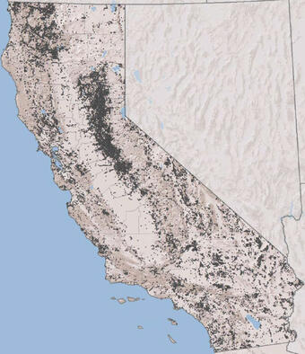
Since 2016, the USGS has been involved in a joint effort with the U.S. Army Corps of Engineers, U.S. Environmental Protection Agency, and California Department of Toxic Substances Control to identify mineral deposit types in abandoned mine lands in California. The USGS role in this partnership has been to identify deposit types for approximately 40,000 of the 42,700 California mine site entries in its Mineral Resources Data System (MRDS).
USGS mineral deposit type classifications are useful in evaluating chemical risk factors at abandoned mine sites. To date, USGS scientists have identified 282 different categories for MRDS entries. Scientists also developed a draft of relative hazard rankings for each deposit type, for prioritizing abandoned mine lands for preliminary risk assessment. Preliminary results indicate that the ranking schemes identify most mine sites known to be risks to human health and the environment, along with other sites that may warrant investigation. This information has proven critical to identifying areas of concern.
Below are other science projects associated with this project.

Examining Erosion at Malakoff Diggins State Historic Park, a Sierra Nevada Gold Mine

Technical Support to the U.S. EPA for Leviathan Mine, Alpine County, California

Iron Mountain: An Extraordinary and Extreme Environment
Better understanding of mineral deposits and their impact on the environment, including the water system, is necessary for the protection of public health. The USGS is working with other federal and state agencies to identify the environmental behavior of these deposits and their waste products. USGS scientists are using geospatial data (data that can be mapped) to prioritize abandoned mine land sites that are of concern in California.
Since 2016, the USGS has been involved in a joint effort with the U.S. Army Corps of Engineers, U.S. Environmental Protection Agency, and California Department of Toxic Substances Control to identify mineral deposit types in abandoned mine lands in California. The USGS role in this partnership has been to identify deposit types for approximately 40,000 of the 42,700 California mine site entries in its Mineral Resources Data System (MRDS).
USGS mineral deposit type classifications are useful in evaluating chemical risk factors at abandoned mine sites. To date, USGS scientists have identified 282 different categories for MRDS entries. Scientists also developed a draft of relative hazard rankings for each deposit type, for prioritizing abandoned mine lands for preliminary risk assessment. Preliminary results indicate that the ranking schemes identify most mine sites known to be risks to human health and the environment, along with other sites that may warrant investigation. This information has proven critical to identifying areas of concern.
Below are other science projects associated with this project.
Examining Erosion at Malakoff Diggins State Historic Park, a Sierra Nevada Gold Mine
Technical Support to the U.S. EPA for Leviathan Mine, Alpine County, California