
Feature Mapping
Feature Mapping
Center of Excellence for Geospatial Information Science (CEGIS)
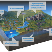
Feature mapping is about marking specific elements like roads, buildings, and natural features on maps to understand landscapes better.
This helps planners make decisions about development and conservation. CEGIS uses feature mapping to study how landscapes change over time, which helps them plan for things like managing forests and predicting floods.


Filter Total Items: 3

2026 18th CEGIS Annual Research Meeting
The Center of Excellence for Geospatial Information Science (CEGIS) is proud to host the 2026 18th CEGIS Annual Research Meeting June 23-25, 2026, in Denver, Colorado. The annual research meeting is a special occasion to celebrate our accomplishments, explore ongoing projects, and foster collaboration for future endeavors. This year's gathering featured a broad range of presentations from our...
2025 CEGIS Annual Research Meeting
The Center of Excellence for Geospatial Information Science (CEGIS) was proud to host the 2025 CEGIS Annual Research Meeting July 22-24, 2025. The annual research meeting is a special occasion to celebrate our accomplishments, explore ongoing projects, and foster collaboration for future endeavors. This year's gathering featured a broad range of presentations from our researchers and their...
Feature mapping
Feature mapping is about identifying specific elements like roads, buildings, and natural features on maps to understand landscapes better. This helps planners make decisions about development and conservation. CEGIS uses feature mapping to study how landscapes change over time, which helps them plan for things like managing forests and predicting floods.