
Terrain
Center of Excellence for Geospatial Information Science (CEGIS)
CEGIS conducts research to better understand the Earth’s surface (terrain) and to create detailed maps.
CEGIS researchers use advanced technology and scientific methods to collect data about the land, including its elevation, shape, and features.
This research is crucial for enhancing our understanding of Earth's surface and making informed decisions related to land and environmental management.
Feature mapping
Feature mapping is about marking specific elements like roads, buildings, and natural features on maps to understand landscapes better.
This helps planners make decisions about development and conservation. CEGIS uses feature mapping to study how landscapes change over time, which helps them plan for things like managing forests and predicting floods.
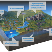
Hydrography/hypsography integration
Hydrography/Hypsography integration, aka Hydro/hypso, involves combining information about water (hydro) and elevation (hypso) to study how water moves across different landscapes.
It helps scientists understand where water flows, accumulates, and how it shapes the land. This helps scientists figure out how to manage water resources and predict flooding or erosion.
Image processing
Image processing helps us study and understand different types of landscapes. It uses satellite, airplane, and other images to make detailed maps of the land and its features.
By using special techniques, like pulling out specific details or making 3D models, image processing helps scientists learn more about the land and how it changes over time.

2026 18th CEGIS Annual Research Meeting
2025 CEGIS Annual Research Meeting

Image processing

Hydrography/hypsography integration
Feature mapping

National terrain mapping
