
Ecological Structure and Function, Large-River Floodplains
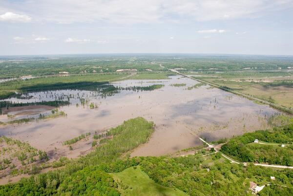
This project seeks to develop tools and datasets that provide insights to the common ground between flood-risk reduction and ecosystem services on large-river floodplains of the Central United States. Floodplains of large rivers are valued for their agricultural productivity and development potential, but recent floods have demonstrated the high costs and lack of resiliency when floodplains are inundated, especially due to erosion and deposition associated with levee breaks. The potential ecological benefits of conservation lands in floodplains also have been recognized, including contributions to recreation, flood-risk reduction, nutrient processing, and biodiversity. Questions faced by decisionmakers are where and how to optimize land uses in floodplains to achieve the greatest net social benefits. A direct and pressing information need relates to design for levee setbacks that provide naturalized land between a levee and the river.
This research has been carried out as a collaboration among the USGS-Columbia Environmental Research Center, USGS-Upper Midwest Environmental Sciences Center, University of Missouri, Southern Illinois University-Carbondale, and The Nature Conservancy
Objectives
The objectives of this project are to provide tools and understanding that can be used to inform floodplain management decisions. Specific objectives include:

- Quantify the spatial and temporal patterns of inundation indices, such as duration, seasonality, extent, and magnitude, for large-river floodplains.
- Develop tools and metrics for distilling, summarizing, and visualizing spatial-temporal patterns of inundation on floodplains.
- Assess the relationships between inundation indices and spatial-temporal patterns of ecosystem services, including habitat availability, biodiversity, recreation, and nutrient processing potential on floodplain lands.
- Generate tools to evaluate alternative design scenarios, including management of levees, topography, vegetation communities, and sedimentation, and how those factors influence the patterns of connectivity and ecosystem services on large-river floodplains.
Approach
Our approach to developing quantitative models of floodplain connectivity has been based on information needed by managers and restorers of floodplain lands (Jacobson and others, 2011). A survey of floodplain conservation land managers indicated that their greatest need was for understanding patterns of present and future inundation (Bouska and others, 2016).

As a result, we developed a range of hydrology and hydraulic modeling tools to evaluate floodplain inundation over a spectrum of spatial and temporal resolutions. These range from steady state 1-dimensional hydraulic models based on frequency statistics (Jacobson and others, 2007; Chojnacki and others, 2012), to unsteady 1-dimensional, high resolution models (Bulliner and others, 2020), to multi-dimensional hydrodynamic models (Jacobson and others, 2015; Erwin and others, 2018). The 1-dimensional unsteady modeling was recently expanded and analyzed in the context of climate change (Jacobson and others, 2022). Present efforts emphasize high-resolution multi-dimensional modeling of floodplains to explore optimal levee-setback designs. For synthesis to a broader scale we also developed a hydrogeomorphic classification of connectivity of large rivers of the Upper Midwest broad-scale classification of large rivers of the Central United States (Jacobson and others, 2019).
Results
Some key results of this research are:
- Floodplain connectivity on the Lower Missouri River is jointly controlled by levee constriction and by long-term geomorphic adjustments to the channel that creates juxtaposed reaches with variable channel incision (hence variable floodplain inundation potential).
- Floodplain connectivity – and flood hazard – is likely to increase under future climate-change conditions as annual and spring-season runoff increase.
- Levee setbacks that provide additional connected floodplain contribute to decreases in flood stages as long as vegetation-induced hydraulic roughness and commonly associated floodplain deposition do not combine to decrease conveyance.
- Flood attenuation is possible when considering modest floods of 2-5 year return interval but is less likely for floods of > 10-year return interval that effectively fill the floodplain. on the floodplains of the Missouri and Middle Mississippi Rivers.
- Whereas denitrification can be substantial in inundated floodplain wetlands, calculations indicate that potential denitrification is small compared to the flux of nitrogen in the Missouri River, amounting to an average of 3.6% as an annual average if all levees were removed.
Return to Riverine Habitat Dynamics
Return to Large River Ecology, Restoration, and Management
Return to River Studies
This project seeks to develop tools and datasets that provide insights to the common ground between flood-risk reduction and ecosystem services on large-river floodplains of the Central United States. Floodplains of large rivers are valued for their agricultural productivity and development potential, but recent floods have demonstrated the high costs and lack of resiliency when floodplains are inundated, especially due to erosion and deposition associated with levee breaks. The potential ecological benefits of conservation lands in floodplains also have been recognized, including contributions to recreation, flood-risk reduction, nutrient processing, and biodiversity. Questions faced by decisionmakers are where and how to optimize land uses in floodplains to achieve the greatest net social benefits. A direct and pressing information need relates to design for levee setbacks that provide naturalized land between a levee and the river.
This research has been carried out as a collaboration among the USGS-Columbia Environmental Research Center, USGS-Upper Midwest Environmental Sciences Center, University of Missouri, Southern Illinois University-Carbondale, and The Nature Conservancy
Objectives
The objectives of this project are to provide tools and understanding that can be used to inform floodplain management decisions. Specific objectives include:
- Quantify the spatial and temporal patterns of inundation indices, such as duration, seasonality, extent, and magnitude, for large-river floodplains.
- Develop tools and metrics for distilling, summarizing, and visualizing spatial-temporal patterns of inundation on floodplains.
- Assess the relationships between inundation indices and spatial-temporal patterns of ecosystem services, including habitat availability, biodiversity, recreation, and nutrient processing potential on floodplain lands.
- Generate tools to evaluate alternative design scenarios, including management of levees, topography, vegetation communities, and sedimentation, and how those factors influence the patterns of connectivity and ecosystem services on large-river floodplains.
Approach
Our approach to developing quantitative models of floodplain connectivity has been based on information needed by managers and restorers of floodplain lands (Jacobson and others, 2011). A survey of floodplain conservation land managers indicated that their greatest need was for understanding patterns of present and future inundation (Bouska and others, 2016).
As a result, we developed a range of hydrology and hydraulic modeling tools to evaluate floodplain inundation over a spectrum of spatial and temporal resolutions. These range from steady state 1-dimensional hydraulic models based on frequency statistics (Jacobson and others, 2007; Chojnacki and others, 2012), to unsteady 1-dimensional, high resolution models (Bulliner and others, 2020), to multi-dimensional hydrodynamic models (Jacobson and others, 2015; Erwin and others, 2018). The 1-dimensional unsteady modeling was recently expanded and analyzed in the context of climate change (Jacobson and others, 2022). Present efforts emphasize high-resolution multi-dimensional modeling of floodplains to explore optimal levee-setback designs. For synthesis to a broader scale we also developed a hydrogeomorphic classification of connectivity of large rivers of the Upper Midwest broad-scale classification of large rivers of the Central United States (Jacobson and others, 2019).
Results
Some key results of this research are:
- Floodplain connectivity on the Lower Missouri River is jointly controlled by levee constriction and by long-term geomorphic adjustments to the channel that creates juxtaposed reaches with variable channel incision (hence variable floodplain inundation potential).
- Floodplain connectivity – and flood hazard – is likely to increase under future climate-change conditions as annual and spring-season runoff increase.
- Levee setbacks that provide additional connected floodplain contribute to decreases in flood stages as long as vegetation-induced hydraulic roughness and commonly associated floodplain deposition do not combine to decrease conveyance.
- Flood attenuation is possible when considering modest floods of 2-5 year return interval but is less likely for floods of > 10-year return interval that effectively fill the floodplain. on the floodplains of the Missouri and Middle Mississippi Rivers.
- Whereas denitrification can be substantial in inundated floodplain wetlands, calculations indicate that potential denitrification is small compared to the flux of nitrogen in the Missouri River, amounting to an average of 3.6% as an annual average if all levees were removed.
Return to Riverine Habitat Dynamics
Return to Large River Ecology, Restoration, and Management
Return to River Studies