An official website of the United States government
Here's how you know
Official websites use .gov
A .gov website belongs to an official government organization in the United States.
Secure .gov websites use HTTPS
A lock () or https:// means you’ve safely connected to the .gov website. Share sensitive information only on official, secure websites.
When the Moderate Resolution Imaging Spectroradiometer (MODIS) was first launched into low Earth orbit 24 years ago, it held the promise of daily and weekly vegetation monitoring data for a host of potential scientific applications.
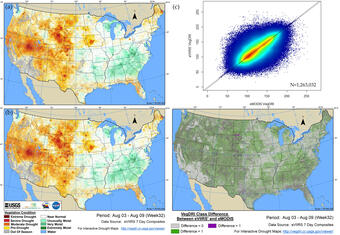
Comparison of Vegetation Drought Response Index (VegDRI) results from EROS expedited Moderate Resolution Imaging Spectroradiometer (eMODIS) (a) and transformed EROS expedited Visible Infrared Imaging Radiometer Suite (eVIIRS') (b) for week 32, 2020 (August 3, 2020 to August 9, 2020). (c) relationship between eMODIS and eVIIRS’ VegDRI values, associated statistics are presented in Table 2, week 32 column. (d) VegDRI classification differences pixel by pixel.
MODIS data, available through NASA’s USGS EROS-based Land Processes Distributed Active Archive Center (LP DAAC), have since proven their worth many times over.
EROS MODIS Normalized Difference Vegetation Index (eMODIS NDVI) and eMODIS Global Land Surface Temperature (LST) data products, meanwhile, have allowed users to more easily apply MODIS data to operational science applications such as VegDRI and QuickDRI.
For years, the eMODIS NDVI and eMODIS Global LST products built at EROS have been a vital vegetation monitoring resource for a wide range of government, academic and commercial research teams.
However, the NASA Terra and Aqua satellites that carry MODIS sensors have nearly reached the end of their lifespan. This will soon bring an end to the era of MODIS data.
The Visible Infrared Imaging Radiometer Suite (VIIRS) instrument aboard the joint NASA/NOAA Suomi National Polar-orbiting Partnership (Suomi NPP) and NOAA-20 satellites will serve as the successor to MODIS. VIIRS enables a new generation of operational moderate resolution-imaging capabilities, following in the footsteps of the Advanced Very High-Resolution Radiometer (AVHRR) on NOAA satellites, and MODIS on Terra and Aqua.
EROS began building EROS VIIRS, or eVIIRS, composites in 2021. The move came in anticipation of the end of the mission life for MODIS. Many users have already switched to eVIIRS composites.
EROS Center teams are now asking users to begin to switch your projects from eMODIS products to the comparable eVIIRS products as soon as possible.
EROS welcomes feedback from the user community on eVIIRS and encourages feedback to USGS EROS User Services.
The eVIIRS NDVI and Global LST composites are available on EarthExplorer (EE). VegDRI and QuickDRI production has transitioned to VIIRS sensor products, and users have been pleased with the results. Web viewers for Vegetation Dynamics Drought Viewer that host these and other products for monitoring drought in the contiguous United States are available in EE alongside eVIIRS NDVI and Global LST..
Please evaluate the eVIIRS products for future use. Barring any satellite data collection or processing issues, eMODIS products will be produced through the summer of 2022. Production of eMODIS products will cease by Oct. 1, 2022.
Read more about eMODIS, eVIIRS, and the various applications that built using the data products at this link.
The EROS Visible Infrared Imaging Radiometer Suite (eVIIRS) Land Surface Temperature (LST) collection is based on the Visible Infrared Imaging Radiometer Suite (VIIRS) data acquired by this VIIRS instrument. VIIRS is aboard the joint NASA/NOAA Suomi National Polar-orbiting Partnership (Suomi NPP) and NOAA-20 satellites.
USGS EROS Archive - Vegetation Monitoring - eVIIRS Land Surface Temperature (LST)
The EROS Visible Infrared Imaging Radiometer Suite (eVIIRS) Land Surface Temperature (LST) collection is based on the Visible Infrared Imaging Radiometer Suite (VIIRS) data acquired by this VIIRS instrument. VIIRS is aboard the joint NASA/NOAA Suomi National Polar-orbiting Partnership (Suomi NPP) and NOAA-20 satellites.
The Earth Resources Observation and Science (EROS) Center Visible Infrared Imaging Radiometer Suite (eVIIRS) collection is based on the Suomi National Polar-orbiting Partnership (S-NPP) Visible Infrared Imaging Radiometer Suite (VIIRS) data acquired by the NPP, which is the result of a partnership between the National Aeronautics and Space Administration (NASA) and the National Oceanic and...
USGS EROS Archive - Vegetation Monitoring - EROS Visible Infrared Imaging Radiometer Suite (eVIIRS)
The Earth Resources Observation and Science (EROS) Center Visible Infrared Imaging Radiometer Suite (eVIIRS) collection is based on the Suomi National Polar-orbiting Partnership (S-NPP) Visible Infrared Imaging Radiometer Suite (VIIRS) data acquired by the NPP, which is the result of a partnership between the National Aeronautics and Space Administration (NASA) and the National Oceanic and...
The EROS Moderate Resolution Imaging Spectroradiometer (eMODIS) Land Surface Temperature (LST) collection is based on the Moderate Resolution Imaging Spectroradiometer (MODIS) data acquired by the National Aeronautics and Space Administration's (NASA) Earth Observing System (EOS). Note: The eMODIS datasets are no longer being produced after October 1st, 2022. These datasets will remain available...
USGS EROS Archive - Vegetation Monitoring - eMODIS Land Surface Temperature
The EROS Moderate Resolution Imaging Spectroradiometer (eMODIS) Land Surface Temperature (LST) collection is based on the Moderate Resolution Imaging Spectroradiometer (MODIS) data acquired by the National Aeronautics and Space Administration's (NASA) Earth Observing System (EOS). Note: The eMODIS datasets are no longer being produced after October 1st, 2022. These datasets will remain available...
Similar in methodology to VegDRI, QuickDRI is a hybrid drought index that incorporates multiple sources of input data informative of drought or rapidly drying conditions. The QuickDRI methodology includes many steps shown in Figure 1.
Similar in methodology to VegDRI, QuickDRI is a hybrid drought index that incorporates multiple sources of input data informative of drought or rapidly drying conditions. The QuickDRI methodology includes many steps shown in Figure 1.
The VegDRI is a hybrid drought index that incorporates multiple sources of input data informative of drought stress. The VegDRI methodology includes many steps shown in Figure 1 and our publications can be consulted for further technical details.
The VegDRI is a hybrid drought index that incorporates multiple sources of input data informative of drought stress. The VegDRI methodology includes many steps shown in Figure 1 and our publications can be consulted for further technical details.
Weekly VegDRI maps integrate remote sensing, climate, and biophysical data to provide timely drought information for the conterminous United States. (2009-present)
USGS EROS Archive - Vegetation Monitoring - Vegetation Drought Response Index (VegDRI)
Weekly VegDRI maps integrate remote sensing, climate, and biophysical data to provide timely drought information for the conterminous United States. (2009-present)
Hear podcasts on Normalized Difference Vegetation Index (NDVI), the Famine Early Warning Systems Network (FEWS NET), which use eMODIS and eVIIRS, and on the satellite constellation that includes NASA's Terra and Aqua satellites, which carry the MODIS instrument.
Eyes on Earth Episode 26 – Satellite Constellations
Between them, Landsats 7 and 8 image the entire land surface of Earth every eight days. The USGS orbiters are just two of many Earth observing satellites flying at the same altitude and collecting data at the same time of day.
Between them, Landsats 7 and 8 image the entire land surface of Earth every eight days. The USGS orbiters are just two of many Earth observing satellites flying at the same altitude and collecting data at the same time of day.
Eyes on Earth Episode 12 – Plant Health via Satellite (NDVI)
A farmer at the foot of a corn stalk can tell how well the plant is faring. That same farmer might survey his entire field for crop health. But assessing the health of crops or forests at regional, national, and international scales requires remote sensing, most often via satellite.
A farmer at the foot of a corn stalk can tell how well the plant is faring. That same farmer might survey his entire field for crop health. But assessing the health of crops or forests at regional, national, and international scales requires remote sensing, most often via satellite.
Nearly 85 million people around the world are currently considered “food insecure,” and that figure continues to grow. Remote sensing technology enables scientists to feed data into the Famine Early Warning Systems Network (FEWS NET), which in turn can issue alerts that guide the distribution of humanitarian aid.
Nearly 85 million people around the world are currently considered “food insecure,” and that figure continues to grow. Remote sensing technology enables scientists to feed data into the Famine Early Warning Systems Network (FEWS NET), which in turn can issue alerts that guide the distribution of humanitarian aid.
QuickDRI, VegDRI Showed Their Value in Montana Drought of 2017
In the spring of 2017, almost no one in Montana saw the drought coming. Not when winter snowpack and early rains soaked the landscapes with adequate...
The EROS Visible Infrared Imaging Radiometer Suite (eVIIRS) Land Surface Temperature (LST) collection is based on the Visible Infrared Imaging Radiometer Suite (VIIRS) data acquired by this VIIRS instrument. VIIRS is aboard the joint NASA/NOAA Suomi National Polar-orbiting Partnership (Suomi NPP) and NOAA-20 satellites.
USGS EROS Archive - Vegetation Monitoring - eVIIRS Land Surface Temperature (LST)
The EROS Visible Infrared Imaging Radiometer Suite (eVIIRS) Land Surface Temperature (LST) collection is based on the Visible Infrared Imaging Radiometer Suite (VIIRS) data acquired by this VIIRS instrument. VIIRS is aboard the joint NASA/NOAA Suomi National Polar-orbiting Partnership (Suomi NPP) and NOAA-20 satellites.
The Earth Resources Observation and Science (EROS) Center Visible Infrared Imaging Radiometer Suite (eVIIRS) collection is based on the Suomi National Polar-orbiting Partnership (S-NPP) Visible Infrared Imaging Radiometer Suite (VIIRS) data acquired by the NPP, which is the result of a partnership between the National Aeronautics and Space Administration (NASA) and the National Oceanic and...
USGS EROS Archive - Vegetation Monitoring - EROS Visible Infrared Imaging Radiometer Suite (eVIIRS)
The Earth Resources Observation and Science (EROS) Center Visible Infrared Imaging Radiometer Suite (eVIIRS) collection is based on the Suomi National Polar-orbiting Partnership (S-NPP) Visible Infrared Imaging Radiometer Suite (VIIRS) data acquired by the NPP, which is the result of a partnership between the National Aeronautics and Space Administration (NASA) and the National Oceanic and...
The EROS Moderate Resolution Imaging Spectroradiometer (eMODIS) Land Surface Temperature (LST) collection is based on the Moderate Resolution Imaging Spectroradiometer (MODIS) data acquired by the National Aeronautics and Space Administration's (NASA) Earth Observing System (EOS). Note: The eMODIS datasets are no longer being produced after October 1st, 2022. These datasets will remain available...
USGS EROS Archive - Vegetation Monitoring - eMODIS Land Surface Temperature
The EROS Moderate Resolution Imaging Spectroradiometer (eMODIS) Land Surface Temperature (LST) collection is based on the Moderate Resolution Imaging Spectroradiometer (MODIS) data acquired by the National Aeronautics and Space Administration's (NASA) Earth Observing System (EOS). Note: The eMODIS datasets are no longer being produced after October 1st, 2022. These datasets will remain available...
Similar in methodology to VegDRI, QuickDRI is a hybrid drought index that incorporates multiple sources of input data informative of drought or rapidly drying conditions. The QuickDRI methodology includes many steps shown in Figure 1.
Similar in methodology to VegDRI, QuickDRI is a hybrid drought index that incorporates multiple sources of input data informative of drought or rapidly drying conditions. The QuickDRI methodology includes many steps shown in Figure 1.
The VegDRI is a hybrid drought index that incorporates multiple sources of input data informative of drought stress. The VegDRI methodology includes many steps shown in Figure 1 and our publications can be consulted for further technical details.
The VegDRI is a hybrid drought index that incorporates multiple sources of input data informative of drought stress. The VegDRI methodology includes many steps shown in Figure 1 and our publications can be consulted for further technical details.
Weekly VegDRI maps integrate remote sensing, climate, and biophysical data to provide timely drought information for the conterminous United States. (2009-present)
USGS EROS Archive - Vegetation Monitoring - Vegetation Drought Response Index (VegDRI)
Weekly VegDRI maps integrate remote sensing, climate, and biophysical data to provide timely drought information for the conterminous United States. (2009-present)
Hear podcasts on Normalized Difference Vegetation Index (NDVI), the Famine Early Warning Systems Network (FEWS NET), which use eMODIS and eVIIRS, and on the satellite constellation that includes NASA's Terra and Aqua satellites, which carry the MODIS instrument.
Eyes on Earth Episode 26 – Satellite Constellations
Between them, Landsats 7 and 8 image the entire land surface of Earth every eight days. The USGS orbiters are just two of many Earth observing satellites flying at the same altitude and collecting data at the same time of day.
Between them, Landsats 7 and 8 image the entire land surface of Earth every eight days. The USGS orbiters are just two of many Earth observing satellites flying at the same altitude and collecting data at the same time of day.
Eyes on Earth Episode 12 – Plant Health via Satellite (NDVI)
A farmer at the foot of a corn stalk can tell how well the plant is faring. That same farmer might survey his entire field for crop health. But assessing the health of crops or forests at regional, national, and international scales requires remote sensing, most often via satellite.
A farmer at the foot of a corn stalk can tell how well the plant is faring. That same farmer might survey his entire field for crop health. But assessing the health of crops or forests at regional, national, and international scales requires remote sensing, most often via satellite.
Nearly 85 million people around the world are currently considered “food insecure,” and that figure continues to grow. Remote sensing technology enables scientists to feed data into the Famine Early Warning Systems Network (FEWS NET), which in turn can issue alerts that guide the distribution of humanitarian aid.
Nearly 85 million people around the world are currently considered “food insecure,” and that figure continues to grow. Remote sensing technology enables scientists to feed data into the Famine Early Warning Systems Network (FEWS NET), which in turn can issue alerts that guide the distribution of humanitarian aid.
QuickDRI, VegDRI Showed Their Value in Montana Drought of 2017
In the spring of 2017, almost no one in Montana saw the drought coming. Not when winter snowpack and early rains soaked the landscapes with adequate...