
Annual NLCD Characteristics, Constraints, and Caveats
This page provides information about specific artifacts that were discovered in review of Annual National Land Cover Database (NLCD) Collection 1.0 or provided by user feedback. These show up in the products listed below.
The annual NLCD Collection 1 Science Products contain known caveats and limitations. Overall considerations regarding the full data set or the NLCD approach are described below.
Land Cover
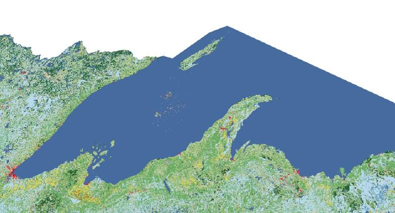
- Water Bodies: Pixelated developed, barren, and other out-of-place land cover calls over water, particularly Lake Superior, are attributed to input issues related to artifacts in the leaf-on/off imagery used.
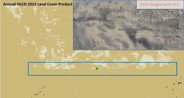
- Shrubs/Grassland Classification Artifacts: Linear artifacts of “blockiness” can be seen in some geographic areas, particularly the desert Southwest where the new spatial AI/ML approach had difficulty differentiating between shrub/scrub and grassland/herbaceous.
- Land cover values are generally associated with an annual July 1st date due to many of the processing steps either centered around that date or use the date explicitly. In this case, spectral change in the second half of the year will be seen in the next year’s land cover.
Not all land cover changes are expected to have an associated spectral change. Gradual changes are modeled within the deep learning architecture, and post classification can produce additional cover changes.
Media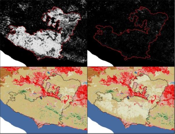 Sources/Usage: Public Domain. View Media Details
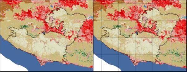
Images above show the Woolsey fire that started on November 8th, 2019. The top left image shows the Annual NLCD spectral day change of year product where you can clearly see the Woolsey fire. Top right image displays the lack of disturbance the following year in 2019 using the spectral day of change product. The bottom two images (bottom left 2018, bottom right 2019) show the land cover changes after the Woolsey fire.
Fractional Impervious Surface
- Value/Range Truncation: Linear regression predictions produced values outside of the accepted 0-100 value range and were not properly truncated. This can cause values to be greater than 100 and, in some cases, cause a buffer underflow for the UINT8 data type.
Land Cover Confidence
- Value/Range Truncation: Linear regression predictions and the nature of the ensemble approach can give values greater than 100, which were not properly truncated.
- Confidence Value Misrepresentations: The wrong class can be referenced for the associated confidence value due to modeling on an expanded set of classes which get cross-walked to the final land cover calls. This often results in a much lower confidence value than intended.
Spectral Change Day of Year
- Striping can occur within detected change areas related to input data (e.g., Landsat 7 SLC-Off stripes).
- A spectral change does not directly translate to a land cover change and can be an ephemeral or low intensity event (e.g., low intensity fire, tree thinning, urban resurfacing …).
Back to the About Annual NLCD page.

About Annual NLCD
This page provides information about specific artifacts that were discovered in review of Annual National Land Cover Database (NLCD) Collection 1.0 or provided by user feedback. These show up in the products listed below.
The annual NLCD Collection 1 Science Products contain known caveats and limitations. Overall considerations regarding the full data set or the NLCD approach are described below.
Land Cover
- Water Bodies: Pixelated developed, barren, and other out-of-place land cover calls over water, particularly Lake Superior, are attributed to input issues related to artifacts in the leaf-on/off imagery used.
- Shrubs/Grassland Classification Artifacts: Linear artifacts of “blockiness” can be seen in some geographic areas, particularly the desert Southwest where the new spatial AI/ML approach had difficulty differentiating between shrub/scrub and grassland/herbaceous.
- Land cover values are generally associated with an annual July 1st date due to many of the processing steps either centered around that date or use the date explicitly. In this case, spectral change in the second half of the year will be seen in the next year’s land cover.
Not all land cover changes are expected to have an associated spectral change. Gradual changes are modeled within the deep learning architecture, and post classification can produce additional cover changes.
Media
Sources/Usage: Public Domain. View Media DetailsImages above show the Woolsey fire that started on November 8th, 2019. The top left image shows the Annual NLCD spectral day change of year product where you can clearly see the Woolsey fire. Top right image displays the lack of disturbance the following year in 2019 using the spectral day of change product. The bottom two images (bottom left 2018, bottom right 2019) show the land cover changes after the Woolsey fire.
Fractional Impervious Surface
- Value/Range Truncation: Linear regression predictions produced values outside of the accepted 0-100 value range and were not properly truncated. This can cause values to be greater than 100 and, in some cases, cause a buffer underflow for the UINT8 data type.
Land Cover Confidence
- Value/Range Truncation: Linear regression predictions and the nature of the ensemble approach can give values greater than 100, which were not properly truncated.
- Confidence Value Misrepresentations: The wrong class can be referenced for the associated confidence value due to modeling on an expanded set of classes which get cross-walked to the final land cover calls. This often results in a much lower confidence value than intended.
Spectral Change Day of Year
- Striping can occur within detected change areas related to input data (e.g., Landsat 7 SLC-Off stripes).
- A spectral change does not directly translate to a land cover change and can be an ephemeral or low intensity event (e.g., low intensity fire, tree thinning, urban resurfacing …).
Back to the About Annual NLCD page.