
About Annual NLCD
Annual NLCD Collection 1.2 is available, adding 2025 data!
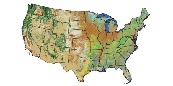
Improving information on the characteristics of land cover, understanding the basic drivers of change, and identifying of potential consequences of change on human and natural systems can empower greater insight into the impacts and feedback of human activity and other drivers. To meet its needs, the geospatial community has called for a new generation of monitoring data and information as input for many applications. Land use land cover (LULC) and land change products need to span larger geographic extents, over longer time periods, at higher spatial resolutions, and provide more systematic and consistent information on change than ever before. To help meet growing user demands, the United States Geological Survey (USGS) has developed the Annual National Land Cover Database (NLCD) Collection 1 Science Products.
Science Product User Guide

Science Product User Guide provides in-depth information on Annual NLCD products and methods and is available for download.
Frequently Asked Questions (FAQs)
The FAQ page list commonly asked questions pertaining to the Annual National Land Cover Database.


Annual NLCD Objectives
- Perform annual monitoring of national land cover and land change (historic and current)
- Create, validate, and distribute map products
- Establish provenance and documentation, transparency, and openness
- Use continuous R&D to enhance change detection, augment classification, reduce latency, and add improvements
- Assess causes and consequences of change through time (assessments, projections)
Legacy NLCD
Since 1992, the NLCD has characterized land cover and land cover change nationwide through processing the Landsat satellite record of the Earth. Legacy NLCD provides data at 30-meter spatial resolution, spatial reference, and descriptive data for characteristics of the land surface such as thematic class (e.g., urban, agriculture, and forest), percent impervious surface, and percent tree canopy cover. In earlier releases, NLCD has included map products across nine epochs from 2001 to 2021 (2001, 2004, 2006, 2008, 2011, 2013, 2016, 2019, and 2021). Learn more about the history of NLCD.
New Collection of Annual NLCD Products
Scientists at the Earth Resources Observation and Science (EROS) Center have developed an integrated science framework to deliver annual land cover and land-cover change products with similar spatial and thematic characteristics as legacy, multi-year USGS LULC products. To provide the most relevant land cover and land cover change information for the Nation, mapped land cover (and derived products) should involve regular repeated production, updating and improvement based on robust research, and validation of land cover and land cover change.
Annual NLCD involves a new methodology using an ensemble of chained deep learning models and harmonic time series analysis. This method supports the creation of validated annual land cover and related products crossing 4 decades and updated on an annual basis. Starting in 2024, USGS produced an annual record of land cover and fractional impervious surface for the conterminous U.S. initially covering the period from 1985 to 2023. An annual update made in June 2025 added 2024 information to the time series, and an update in June 2026 added 2025 information. Products for Alaska and Hawaii are planned for 2027.
Citation
U.S. Geological Survey (USGS), 2024, Annual NLCD Collection 1 Science Products: U.S. Geological Survey data release, https://doi.org/10.5066/P94UXNTS
2023 Annual NLCD Poster
Download the 2023 Annual NLCD poster!

Annual NLCD Frequently Asked Questions (FAQs)
Many commonly asked questions can be found on the Annual NLCD FAQ page. Click here to access the FAQ page.
Annual NLCD Characteristics, Constraints, and Caveats
To learn more about the specific artifacts that were discovered in the review of the Annual NLCD, please click here on the link.
Back to the Annual NLCD landing page.
Related Articles
-
Annual NLCD Collection 1.2 Now Available Annual NLCD Collection 1.2 Now Available
The U.S. Geological Survey (USGS) is excited to announce the release of the Annual National Land Cover Database (NLCD) Conterminous U.S. (CU), Collection 1.2. This release builds on the popular Annual NLCD CU Collection 1.0 by extending the dataset through 2025.
Annual NLCD Lengthens Land Cover Record to 40 Years Annual NLCD Lengthens Land Cover Record to 40 Years
The U.S. Geological Survey (USGS) Earth Resources Observation and Science (EROS) Center and the National Land Cover Database (NLCD) project are excited to announce the release of Annual NLCD Conterminous U.S. (CU) Collection 1.1.
USGS Releases New Products that Map Four Decades of Land Cover Change USGS Releases New Products that Map Four Decades of Land Cover Change
RESTON, Va. — The U.S. Geological Survey today released a newly updated and improved National Land Cover Database, known as Annual NLCD, which offers insights into the changing characteristics of landscapes across the conterminous United States from 1985 to 2023.
USGS Reinvents Widely Used NLCD USGS Reinvents Widely Used NLCD
On your next drive, really look at what covers the landscape: Sprawling housing developments? Crowded skyscrapers? Parking lots? Farm fields? Forests? Rivers? The USGS has led the way in accurately mapping this land cover across the country with the National Land Cover Database (NLCD) for more than two decades. Now NLCD debuts big improvements under a new name: Annual NLCD.
Annual NLCD’s Insights Rely on Long Landsat Record Annual NLCD’s Insights Rely on Long Landsat Record
Sometimes it takes distance to really see something. Take the Earth observing Landsat satellites. They’re orbiting 438 miles above us, but they capture data about what’s on the ground surrounding us—and in remote places that very few have walked.
NLCD: Landscape Info Supporting our Safety and Economic Well-being NLCD: Landscape Info Supporting our Safety and Economic Well-being
Hurricane flooding. City planning. A new natural gas pipeline. Preparing for future events—whether sudden or expected—requires high-quality data to ensure our safety, economic well-being and business needs. The National Land Cover Database (NLCD) is a proven data source filling the need in these circumstances and many others for the private sector, all levels of government and universities.
NLCD’s Path from Early Landscape Snapshot to Decades of Change NLCD’s Path from Early Landscape Snapshot to Decades of Change
The widely used National Land Cover Database (NLCD) has long been the foundational land cover source for scientists, resource managers, and decision-makers across the United States, trusted for its accurate and unbiased data. Here, we’re exploring the evolution of NLCD through its reinvention this year as Annual NLCD.
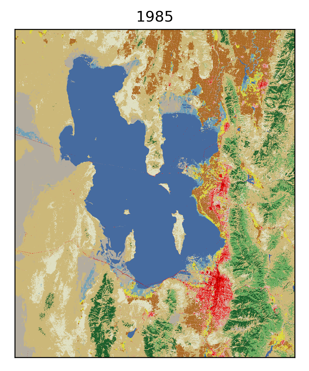
Plenty of Water in Prairie Potholes Plenty of Water in Prairie Potholes
The landscape of the Prairie Pothole Region of North and South Dakota formed when glaciers from the last ice age receded. The potholes are shallow depressional wetlands left behind by the glaciers now popular with migratory waterfowl.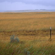
When Crops Take a Break When Crops Take a Break
Agricultural crops are grown on nearly 16% of the land across the lower 48 states. Thanks to the Landsat Satellite Program and the U.S. Geological Survey’s Annual National Land Cover Database (NLCD), we can tell where cropland has remained stable as cropland over the past 39 years. We can also see where it has changed from something else into cropland, or from cropland into something else.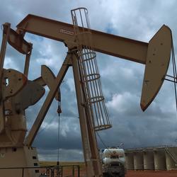
A View of Vigorous Growth: Williston, North Dakota A View of Vigorous Growth: Williston, North Dakota
When we think of growth across the United States, we tend to think of medium or large cities with suburbs that expand into the surrounding area, such as cropland or forest or even desert. But growth happens in small towns, too—sometimes quite quickly for very specific reasons.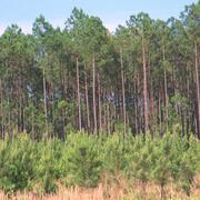
Watching the ‘Wood Basket’ of the U.S. Watching the ‘Wood Basket’ of the U.S.
The southeastern United States is an important wood-producing region of the world, sometimes referred to as the wood basket. The state of Georgia is a global forestry leader, and according to the Georgia Forestry Commission, Georgia has more acres of plantations, timberland and privately owned timberland than any other state (GFC, 2025).
Annual NLCD Assessment: Phosphate Mining and Land Cover Change Annual NLCD Assessment: Phosphate Mining and Land Cover Change
Populations around the world are increasing (US Census Bureau, 2023). As agriculture tries to keep up with feeding this growing population, the use of phosphate fertilizers has risen (FAO, 2019). Phosphorus is a nutrient required for plant growth, and there is no substitute.
-
-
Stories of Change on our Landscape Stories of Change on our Landscape
Scientists, private industry and all levels of government have relied on the definitive National Land Cover Database (NLCD) for years to detail what can be found on the ground, from grassland and cropland to forests and wetlands. Thanks to Landsat's continuous record, Annual NLCD allows people to see 40 years of change, with updates added each year.
Related Multimedia
-
-

Visualizing Land Cover with MRLC Tools
This video is a recording of a previous webinar entitled: “Visualizing Land Cover with MRLC Tools”. This webinar was recorded on January 20, 2026. The United States Geological Survey (USGS) Earth Resources Observation and Science (EROS) Center maintains one of the largest civilian collection of images of the Earth’s land surface. At EROS we study land change and produce land change data products...
-
 Viewer Tool Demo")
MRLC National Land Cover Database (NLCD) Viewer Tool Demo
This video is a demonstration of the MRLC National Land Cover Database (NLCD) Viewer tool. It was conducted during the January 20, 2026 webinar. To watch the full webinar please visit: https://www.usgs.gov/media/videos/visualizing-land-cover-mrlc-tools.
-
 Tool Demo")
MRLC Enhanced Visualization and Analysis (EVA) Tool Demo
This video is a demonstration of the EVA Tool. It was conducted during the January 20, 2026 webinar. To watch the full webinar please visit: https://www.usgs.gov/media/videos/visualizing-land-cover-mrlc-tools.
-
 National Land Cover Database: Improving on a 30-Year Legacy")
The New Annual (1985-2023) National Land Cover Database: Improving on a 30-Year Legacy
This video is a recording of a previous webinar entitled: “The New Annual (1985-2023) National Land Cover Database: Improving on a 30-year Legacy.” This webinar was recorded on October 24, 2024 at the USGS EROS. The United States Geological Survey (USGS) Earth Resources Observation and Science (EROS) Center maintains one of the largest civilian collection of images of the Earth’s land surface. At...
-

Eyes on Earth Episode 126 – Annual NLCD
In this episode of Eyes on Earth, we talk about the latest release of the National Land Cover Database (NLCD). More than just a map, NLCD is a stack of maps—a database. It has long been the foundational land cover source for scientists, resource managers, and decision-makers across the United States, and now the next generation of USGS land cover mapping is here. This new release includes land...
-

Eyes on Earth Episode 130 – NLCD Accuracy
Every pixel has a story. At least that’s how land remote sensing scientist Jo Horton sees it. The new Annual National Land Cover Database (NLCD) was just released in October 2024. NLCD is widely used for land cover and change research in the U.S. That’s why the Reference and Validation team provides accuracy metrics to users, and this work allows EROS to move land cover mapping science forward...
-

Eyes on Earth Episode 131 – Using AI in Geospatial Work
Eyes on Earth tackles artificial intelligence (AI) in a 2-part episode. AI is quickly becoming a necessary part of geospatial work at EROS, helping us efficiently do science to better manage our world. In Part 1, EROS Director Pete Doucette discusses AI and its current and upcoming impact on our work at EROS. To help clarify AI terminology such as machine learning, deep learning, neural networks...
-
Related Data and Publications
-
Annual NLCD (National Land Cover Database)—The next generation of land cover mapping Annual NLCD (National Land Cover Database)—The next generation of land cover mapping
Introduction The widely used National Land Cover Database (NLCD) has long been the foundational land cover source for scientists, resource managers, and decision makers across the United States. In 2024, a reinvention as Annual NLCD added the key improvement of annual time steps to show decades of change at a higher frequency than the intervals of 2–3 years used in the legacy NLCD...Annual National Land Cover Database (NLCD) Collection 1.0 Validation Tables Annual National Land Cover Database (NLCD) Collection 1.0 Validation Tables
A validation assessment of Annual National Land Cover Dataset (NLCD) CONUS Collection 1.0 annual land cover products (1985–2023) for the Conterminous United States (CONUS) was conducted with an independently collected reference dataset. Reference data land cover attributes were assigned by trained interpreters for each year of the time series (1984–2023) to a reference sample of 8,360...Annual National Land Cover Database (NLCD) Collection 1.0 Reference Data Product Annual National Land Cover Database (NLCD) Collection 1.0 Reference Data Product
This Annual NLCD Reference Data Product includes the collection of an independent dataset of 8,360 30-meter by 30-meter samples across the Conterminous United States (CONUS). The Annual NLCD Collection 1 sample design was developed as a two-phase collection by a team of image interpreters as follows: an initial base sample containing 5,000 sample plots chosen purely by simple random...Preliminary Land Cover Data Collected for Protocol and Process Development related to Annual NLCD Preliminary Land Cover Data Collected for Protocol and Process Development related to Annual NLCD
Data collected to facilitate research and development activities pertaining to Annual NLCD algorithm development used as a benchmark for algorithm improvement iterations. The primary goal of these preliminary data was to offer preliminary insight into algorithm performance and guidance for algorithm improvement through error analysis.Annual National Land Cover Database (NLCD) Collection 1 Products (ver. 1.2, June 2026) Annual National Land Cover Database (NLCD) Collection 1 Products (ver. 1.2, June 2026)
The U.S. Geological Survey (USGS)’s Land Cover program has leveraged methodologies from legacy land cover projects - National Land Cover Database (NLCD) and Land Change Monitoring, Assessment, and Projection (LCMAP) - together with modern innovations in geospatial deep learning technologies to create the next generation of land cover and land change information. The product suite is...
Annual National Land Cover Database Frequently Asked Questions
Improving information on the characteristics of land cover, understanding the basic drivers of change, and identifying of potential consequences of change on human and natural systems can empower greater insight into the impacts and feedback of human activity and other drivers. To meet its needs, the geospatial community has called for a new generation of monitoring data and information as input for many applications. Land use land cover (LULC) and land change products need to span larger geographic extents, over longer time periods, at higher spatial resolutions, and provide more systematic and consistent information on change than ever before. To help meet growing user demands, the United States Geological Survey (USGS) has developed the Annual National Land Cover Database (NLCD) Collection 1 Science Products.
Science Product User Guide
Science Product User Guide provides in-depth information on Annual NLCD products and methods and is available for download.
Frequently Asked Questions (FAQs)
The FAQ page list commonly asked questions pertaining to the Annual National Land Cover Database.
Annual NLCD Objectives
- Perform annual monitoring of national land cover and land change (historic and current)
- Create, validate, and distribute map products
- Establish provenance and documentation, transparency, and openness
- Use continuous R&D to enhance change detection, augment classification, reduce latency, and add improvements
- Assess causes and consequences of change through time (assessments, projections)
Legacy NLCD
Since 1992, the NLCD has characterized land cover and land cover change nationwide through processing the Landsat satellite record of the Earth. Legacy NLCD provides data at 30-meter spatial resolution, spatial reference, and descriptive data for characteristics of the land surface such as thematic class (e.g., urban, agriculture, and forest), percent impervious surface, and percent tree canopy cover. In earlier releases, NLCD has included map products across nine epochs from 2001 to 2021 (2001, 2004, 2006, 2008, 2011, 2013, 2016, 2019, and 2021). Learn more about the history of NLCD.
New Collection of Annual NLCD Products
Scientists at the Earth Resources Observation and Science (EROS) Center have developed an integrated science framework to deliver annual land cover and land-cover change products with similar spatial and thematic characteristics as legacy, multi-year USGS LULC products. To provide the most relevant land cover and land cover change information for the Nation, mapped land cover (and derived products) should involve regular repeated production, updating and improvement based on robust research, and validation of land cover and land cover change.
Annual NLCD involves a new methodology using an ensemble of chained deep learning models and harmonic time series analysis. This method supports the creation of validated annual land cover and related products crossing 4 decades and updated on an annual basis. Starting in 2024, USGS produced an annual record of land cover and fractional impervious surface for the conterminous U.S. initially covering the period from 1985 to 2023. An annual update made in June 2025 added 2024 information to the time series, and an update in June 2026 added 2025 information. Products for Alaska and Hawaii are planned for 2027.
Citation
U.S. Geological Survey (USGS), 2024, Annual NLCD Collection 1 Science Products: U.S. Geological Survey data release, https://doi.org/10.5066/P94UXNTS
2023 Annual NLCD Poster
Download the 2023 Annual NLCD poster!
Annual NLCD Frequently Asked Questions (FAQs)
Many commonly asked questions can be found on the Annual NLCD FAQ page. Click here to access the FAQ page.
Annual NLCD Characteristics, Constraints, and Caveats
To learn more about the specific artifacts that were discovered in the review of the Annual NLCD, please click here on the link.
Back to the Annual NLCD landing page.
Related Articles
-
-
Annual NLCD Collection 1.2 Now Available Annual NLCD Collection 1.2 Now Available
The U.S. Geological Survey (USGS) is excited to announce the release of the Annual National Land Cover Database (NLCD) Conterminous U.S. (CU), Collection 1.2. This release builds on the popular Annual NLCD CU Collection 1.0 by extending the dataset through 2025. -
Annual NLCD Lengthens Land Cover Record to 40 Years Annual NLCD Lengthens Land Cover Record to 40 Years
The U.S. Geological Survey (USGS) Earth Resources Observation and Science (EROS) Center and the National Land Cover Database (NLCD) project are excited to announce the release of Annual NLCD Conterminous U.S. (CU) Collection 1.1. -
USGS Releases New Products that Map Four Decades of Land Cover Change USGS Releases New Products that Map Four Decades of Land Cover Change
RESTON, Va. — The U.S. Geological Survey today released a newly updated and improved National Land Cover Database, known as Annual NLCD, which offers insights into the changing characteristics of landscapes across the conterminous United States from 1985 to 2023. -
USGS Reinvents Widely Used NLCD USGS Reinvents Widely Used NLCD
On your next drive, really look at what covers the landscape: Sprawling housing developments? Crowded skyscrapers? Parking lots? Farm fields? Forests? Rivers? The USGS has led the way in accurately mapping this land cover across the country with the National Land Cover Database (NLCD) for more than two decades. Now NLCD debuts big improvements under a new name: Annual NLCD. -
Annual NLCD’s Insights Rely on Long Landsat Record Annual NLCD’s Insights Rely on Long Landsat Record
Sometimes it takes distance to really see something. Take the Earth observing Landsat satellites. They’re orbiting 438 miles above us, but they capture data about what’s on the ground surrounding us—and in remote places that very few have walked. -
NLCD: Landscape Info Supporting our Safety and Economic Well-being NLCD: Landscape Info Supporting our Safety and Economic Well-being
Hurricane flooding. City planning. A new natural gas pipeline. Preparing for future events—whether sudden or expected—requires high-quality data to ensure our safety, economic well-being and business needs. The National Land Cover Database (NLCD) is a proven data source filling the need in these circumstances and many others for the private sector, all levels of government and universities. -
NLCD’s Path from Early Landscape Snapshot to Decades of Change NLCD’s Path from Early Landscape Snapshot to Decades of Change
The widely used National Land Cover Database (NLCD) has long been the foundational land cover source for scientists, resource managers, and decision-makers across the United States, trusted for its accurate and unbiased data. Here, we’re exploring the evolution of NLCD through its reinvention this year as Annual NLCD. -
Plenty of Water in Prairie Potholes Plenty of Water in Prairie Potholes
The landscape of the Prairie Pothole Region of North and South Dakota formed when glaciers from the last ice age receded. The potholes are shallow depressional wetlands left behind by the glaciers now popular with migratory waterfowl. -
When Crops Take a Break When Crops Take a Break
Agricultural crops are grown on nearly 16% of the land across the lower 48 states. Thanks to the Landsat Satellite Program and the U.S. Geological Survey’s Annual National Land Cover Database (NLCD), we can tell where cropland has remained stable as cropland over the past 39 years. We can also see where it has changed from something else into cropland, or from cropland into something else. -
A View of Vigorous Growth: Williston, North Dakota A View of Vigorous Growth: Williston, North Dakota
When we think of growth across the United States, we tend to think of medium or large cities with suburbs that expand into the surrounding area, such as cropland or forest or even desert. But growth happens in small towns, too—sometimes quite quickly for very specific reasons. -
Watching the ‘Wood Basket’ of the U.S. Watching the ‘Wood Basket’ of the U.S.
The southeastern United States is an important wood-producing region of the world, sometimes referred to as the wood basket. The state of Georgia is a global forestry leader, and according to the Georgia Forestry Commission, Georgia has more acres of plantations, timberland and privately owned timberland than any other state (GFC, 2025). -
Annual NLCD Assessment: Phosphate Mining and Land Cover Change Annual NLCD Assessment: Phosphate Mining and Land Cover Change
Populations around the world are increasing (US Census Bureau, 2023). As agriculture tries to keep up with feeding this growing population, the use of phosphate fertilizers has risen (FAO, 2019). Phosphorus is a nutrient required for plant growth, and there is no substitute.
-
-
Stories of Change on our Landscape Stories of Change on our Landscape
Scientists, private industry and all levels of government have relied on the definitive National Land Cover Database (NLCD) for years to detail what can be found on the ground, from grassland and cropland to forests and wetlands. Thanks to Landsat's continuous record, Annual NLCD allows people to see 40 years of change, with updates added each year.
Related Multimedia
-
-
Visualizing Land Cover with MRLC Tools
This video is a recording of a previous webinar entitled: “Visualizing Land Cover with MRLC Tools”. This webinar was recorded on January 20, 2026. The United States Geological Survey (USGS) Earth Resources Observation and Science (EROS) Center maintains one of the largest civilian collection of images of the Earth’s land surface. At EROS we study land change and produce land change data products...
-
MRLC National Land Cover Database (NLCD) Viewer Tool Demo
This video is a demonstration of the MRLC National Land Cover Database (NLCD) Viewer tool. It was conducted during the January 20, 2026 webinar. To watch the full webinar please visit: https://www.usgs.gov/media/videos/visualizing-land-cover-mrlc-tools.
-
MRLC Enhanced Visualization and Analysis (EVA) Tool Demo
This video is a demonstration of the EVA Tool. It was conducted during the January 20, 2026 webinar. To watch the full webinar please visit: https://www.usgs.gov/media/videos/visualizing-land-cover-mrlc-tools.
-
The New Annual (1985-2023) National Land Cover Database: Improving on a 30-Year Legacy
This video is a recording of a previous webinar entitled: “The New Annual (1985-2023) National Land Cover Database: Improving on a 30-year Legacy.” This webinar was recorded on October 24, 2024 at the USGS EROS. The United States Geological Survey (USGS) Earth Resources Observation and Science (EROS) Center maintains one of the largest civilian collection of images of the Earth’s land surface. At...
-
Eyes on Earth Episode 126 – Annual NLCD
In this episode of Eyes on Earth, we talk about the latest release of the National Land Cover Database (NLCD). More than just a map, NLCD is a stack of maps—a database. It has long been the foundational land cover source for scientists, resource managers, and decision-makers across the United States, and now the next generation of USGS land cover mapping is here. This new release includes land...
-
Eyes on Earth Episode 130 – NLCD Accuracy
Every pixel has a story. At least that’s how land remote sensing scientist Jo Horton sees it. The new Annual National Land Cover Database (NLCD) was just released in October 2024. NLCD is widely used for land cover and change research in the U.S. That’s why the Reference and Validation team provides accuracy metrics to users, and this work allows EROS to move land cover mapping science forward...
-
Eyes on Earth Episode 131 – Using AI in Geospatial Work
Eyes on Earth tackles artificial intelligence (AI) in a 2-part episode. AI is quickly becoming a necessary part of geospatial work at EROS, helping us efficiently do science to better manage our world. In Part 1, EROS Director Pete Doucette discusses AI and its current and upcoming impact on our work at EROS. To help clarify AI terminology such as machine learning, deep learning, neural networks...
-
Related Data and Publications
-
Annual NLCD (National Land Cover Database)—The next generation of land cover mapping Annual NLCD (National Land Cover Database)—The next generation of land cover mapping
Introduction The widely used National Land Cover Database (NLCD) has long been the foundational land cover source for scientists, resource managers, and decision makers across the United States. In 2024, a reinvention as Annual NLCD added the key improvement of annual time steps to show decades of change at a higher frequency than the intervals of 2–3 years used in the legacy NLCD...Annual National Land Cover Database (NLCD) Collection 1.0 Validation Tables Annual National Land Cover Database (NLCD) Collection 1.0 Validation Tables
A validation assessment of Annual National Land Cover Dataset (NLCD) CONUS Collection 1.0 annual land cover products (1985–2023) for the Conterminous United States (CONUS) was conducted with an independently collected reference dataset. Reference data land cover attributes were assigned by trained interpreters for each year of the time series (1984–2023) to a reference sample of 8,360...Annual National Land Cover Database (NLCD) Collection 1.0 Reference Data Product Annual National Land Cover Database (NLCD) Collection 1.0 Reference Data Product
This Annual NLCD Reference Data Product includes the collection of an independent dataset of 8,360 30-meter by 30-meter samples across the Conterminous United States (CONUS). The Annual NLCD Collection 1 sample design was developed as a two-phase collection by a team of image interpreters as follows: an initial base sample containing 5,000 sample plots chosen purely by simple random...Preliminary Land Cover Data Collected for Protocol and Process Development related to Annual NLCD Preliminary Land Cover Data Collected for Protocol and Process Development related to Annual NLCD
Data collected to facilitate research and development activities pertaining to Annual NLCD algorithm development used as a benchmark for algorithm improvement iterations. The primary goal of these preliminary data was to offer preliminary insight into algorithm performance and guidance for algorithm improvement through error analysis.Annual National Land Cover Database (NLCD) Collection 1 Products (ver. 1.2, June 2026) Annual National Land Cover Database (NLCD) Collection 1 Products (ver. 1.2, June 2026)
The U.S. Geological Survey (USGS)’s Land Cover program has leveraged methodologies from legacy land cover projects - National Land Cover Database (NLCD) and Land Change Monitoring, Assessment, and Projection (LCMAP) - together with modern innovations in geospatial deep learning technologies to create the next generation of land cover and land change information. The product suite is...