USGS EROS Archive – Land Cover – Annual NLCD Collection 1 Land Cover
The primary NLCD Land Cover product represents the predominant state of the surface within the mapping year with respect to broad categories of natural and anthropogenic surface cover types.
The National Land Cover Database (NLCD) project announces (June 25, 2025) the release of Annual NLCD Conterminous U.S. (CU), Collection 1.1. With this release, Collection 1.1 adds 2024 to the temporal extent for the 6 annual land cover products. The Annual NLCD products consist of 40 years of CU land cover dynamics.

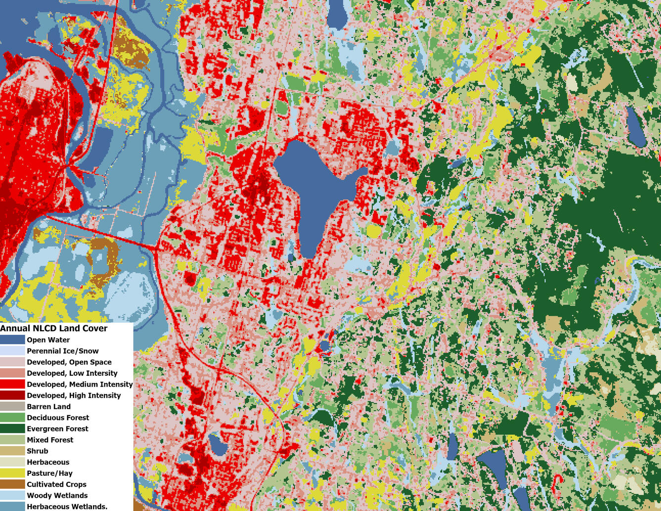
Annual NLCD land cover in the h04v01tile in the Northwest United States.
Annual National Land Cover Database (NLCD) project has created a product suite of land cover and land use change products for the United States at 30-meter spatial resolution on an annual time step from 1985-2023, with subsequent releases updating and extending the product series to additional years. Annual NLCD uses deep learning models to create an annual record of land cover and fractional impervious surfaces for the conterminous U.S.
Annual NLCD Collection 1 Product Suite products are processed to 30-meter resolution on an Albers Equal Area Conic (AEA) projection using the World Geodetic System 1984 (WGS84) datum. Annual NLCD products are created as raster images stored as GeoTIFFs with accompanying metadata. The products delivered via EarthExplorer (EE) are Tiled products processed to a common tiling scheme of uniform dimensions bounded by static corner points in a defined grid system. Each tile contains 5,000 x 5,000 30-meter pixels.
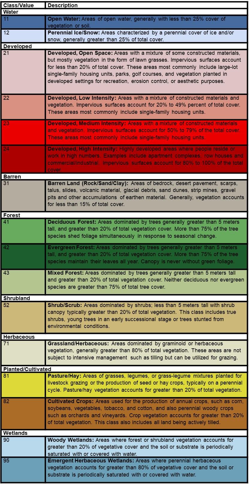
Annual NLCD Land Cover Legend
The annual NLCD land cover dataset uses a modified Anderson Level II classification system with 16 land cover classes. This classification system is derived from the original Anderson land use and land cover classification system, which was designed as a compromise among the need for compatibility with existing classification systems across U.S. federal agencies, separability using primarily remote sensing data, and logical, hierarchical relationships among classes (Anderson et al., 1976).
These classes only include CONUS.

Additional Information
- Annual National Land Cover Database
- Annual NLCD Science Product User Guide
- Annual NLCD Reference and Validation
- Accuracy Assessment Publication
Access Data
EarthExplorer (EE) can be used to search, preview, and download Annual NLCD Land Cover dataset. The collection is available under the Land Cover > Annual NLCD Product Suite category. The data provided via EE are Tiled products.
Annual NLCD Collection 1 Product Suite are also distributed by the MRLC Web Viewer, the MRLC Mosaic Download website, ScienceBase, as Annual NLCD web services, and through USGS AWS S3 (Oregon us-west-2 region). Each distribution site provides its own unique options for the products and services they provide.
Download Package
The download package is a zipfile containing all years per tile per product.
Example of zip bundle:
Tile: H21V15
Product = Land Cover
Years = 1985 to 2024 (40 years)
Files = .tif, .xml, and .aux.tif (3 files per tile per year)
Within zip bundle for tile H21V15 would be 120 files for Annual NLCD C1 Landcover.
Product Digital Object Identifier (DOI)#
Citation
Annual NLCD Product Suite Citation Information
Annual NLCD has no restrictions on the use of science products. Annual NLCD does ask that if you use the data as part of a publication or presentation that use the following citation below; however, it is not a requirement to use the data.
U.S. Geological Survey (USGS), 2024, Annual NLCD Collection 1 Science Products: U.S. Geological Survey data release, https://doi.org/10.5066/P94UXNTS
The primary NLCD Land Cover product represents the predominant state of the surface within the mapping year with respect to broad categories of natural and anthropogenic surface cover types.
The National Land Cover Database (NLCD) project announces (June 25, 2025) the release of Annual NLCD Conterminous U.S. (CU), Collection 1.1. With this release, Collection 1.1 adds 2024 to the temporal extent for the 6 annual land cover products. The Annual NLCD products consist of 40 years of CU land cover dynamics.

Annual NLCD land cover in the h04v01tile in the Northwest United States.
Annual National Land Cover Database (NLCD) project has created a product suite of land cover and land use change products for the United States at 30-meter spatial resolution on an annual time step from 1985-2023, with subsequent releases updating and extending the product series to additional years. Annual NLCD uses deep learning models to create an annual record of land cover and fractional impervious surfaces for the conterminous U.S.
Annual NLCD Collection 1 Product Suite products are processed to 30-meter resolution on an Albers Equal Area Conic (AEA) projection using the World Geodetic System 1984 (WGS84) datum. Annual NLCD products are created as raster images stored as GeoTIFFs with accompanying metadata. The products delivered via EarthExplorer (EE) are Tiled products processed to a common tiling scheme of uniform dimensions bounded by static corner points in a defined grid system. Each tile contains 5,000 x 5,000 30-meter pixels.
Annual NLCD Land Cover Legend
The annual NLCD land cover dataset uses a modified Anderson Level II classification system with 16 land cover classes. This classification system is derived from the original Anderson land use and land cover classification system, which was designed as a compromise among the need for compatibility with existing classification systems across U.S. federal agencies, separability using primarily remote sensing data, and logical, hierarchical relationships among classes (Anderson et al., 1976).
These classes only include CONUS.

Additional Information
- Annual National Land Cover Database
- Annual NLCD Science Product User Guide
- Annual NLCD Reference and Validation
- Accuracy Assessment Publication
Access Data
EarthExplorer (EE) can be used to search, preview, and download Annual NLCD Land Cover dataset. The collection is available under the Land Cover > Annual NLCD Product Suite category. The data provided via EE are Tiled products.
Annual NLCD Collection 1 Product Suite are also distributed by the MRLC Web Viewer, the MRLC Mosaic Download website, ScienceBase, as Annual NLCD web services, and through USGS AWS S3 (Oregon us-west-2 region). Each distribution site provides its own unique options for the products and services they provide.
Download Package
The download package is a zipfile containing all years per tile per product.
Example of zip bundle:
Tile: H21V15
Product = Land Cover
Years = 1985 to 2024 (40 years)
Files = .tif, .xml, and .aux.tif (3 files per tile per year)
Within zip bundle for tile H21V15 would be 120 files for Annual NLCD C1 Landcover.
Product Digital Object Identifier (DOI)#
Citation
Annual NLCD Product Suite Citation Information
Annual NLCD has no restrictions on the use of science products. Annual NLCD does ask that if you use the data as part of a publication or presentation that use the following citation below; however, it is not a requirement to use the data.
U.S. Geological Survey (USGS), 2024, Annual NLCD Collection 1 Science Products: U.S. Geological Survey data release, https://doi.org/10.5066/P94UXNTS

