
Reconstructing Flow History From Riparian Tree Rings
FORT aquatic scientists analyze rings of riparian trees relating tree growth and establishment to historical flow. They then use the tree rings to reconstruct the flow in past centuries. Flow reconstructions discover the frequency and magnitude of past droughts and floods—information that is essential for management of rivers and water supplies.
They have pioneered the use of cottonwood, a dominant riparian species, for tree ring analysis; this is a significant advance in arid regions where old trees of other species are scarce. Ongoing studies focus on rivers of the Upper Colorado and Upper Missouri River Basins. Below are some highlights of this work.
Short- and long-term responses of riparian cottonwoods to flow diversion
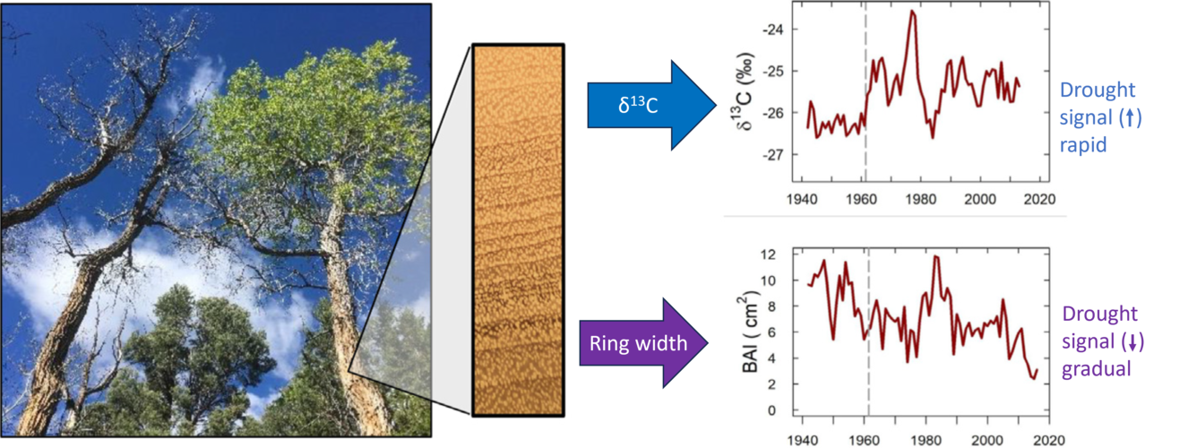
Researchers investigated how hydrological drought affected tree growth and death at annual to half-century scales in a partially dewatered reach compared to reference reaches immediately upstream and downstream. Following diversion of flow from Snake Creek in Great Basin National Park, stable isotopes of carbon showed a rapid, sustained drought response, while ring width decreased gradually, and tree mortality was delayed by half a century. BAI = basal area increment, a measure of tree ring width in squared centimeters; δ13C = the ratio of the stable carbon isotopes 13C and 12C in a tree ring; this ratio increases when the tree is stressed by drought.
Flow reconstructions in the Upper Missouri River Basin using riparian tree rings
Cottonwood forests dominate river flood plains in dry regions of North America, Asia and Europe. Flood-plain cottonwoods are widely distributed and long-lived and have distinct annual rings highly correlated with river flow.


Cores collected throughout this study are currently archived in the University of Arizona Laboratory of Tree Ring Research Collection.


Sediment-ecological connectivity in a large river network
Cottonwood forest establishment occurs on new sediment deposits

Seventy percent of the cottonwood forest area at Deerlodge Park along the Yampa River in Dinosaur National Monument, CO was established 1880–1930 during a period of extreme erosion upstream in the Little Snake Basin. Intense grazing and flash floods caused erosion of sand in tributaries, and the sand was transported downstream to the Yampa, where it formed new sandbars for cottonwood establishment. Thus, extreme erosion in tributaries helped to form a highly valued forest far downstream.
Influence of flow variability on floodplain formation and destruction, Little Missouri River, North Dakota
In this study, researchers mapped floodplain changes in a section of the Little Missouri River using a series of images of the river section taken across ~70 years. They found that high flows were associated with higher floodplain destruction, and reduced flow over the decades has resulted in an overall decrease in floodplain destruction.

This study dataset includes aerial imagery of the Little Missouri River in the North Unit of Theodore Roosevelt National Park, ND from 1939 to 2005, as well as shape files delineating the channel in each image. These data were analyzed in:
Miller, J.R., and J.M. Friedman. 2009. Influence of flow variability on flood-plain formation and destruction, Little Missouri River, North Dakota. Geological Society of America Bulletin 121:752-759. https://doi.org/10.1130/B26355.1
Tree Ring Data

All tree ring data for this project are archived in the International Tree-Ring Data Bank (ITRDB). This data is searchable and publicly available.
Additional datasets outside of ScienceBase
FORT aquatic scientists analyze rings of riparian trees relating tree growth and establishment to historical flow. They then use the tree rings to reconstruct the flow in past centuries. Flow reconstructions discover the frequency and magnitude of past droughts and floods—information that is essential for management of rivers and water supplies.
They have pioneered the use of cottonwood, a dominant riparian species, for tree ring analysis; this is a significant advance in arid regions where old trees of other species are scarce. Ongoing studies focus on rivers of the Upper Colorado and Upper Missouri River Basins. Below are some highlights of this work.
Short- and long-term responses of riparian cottonwoods to flow diversion
Researchers investigated how hydrological drought affected tree growth and death at annual to half-century scales in a partially dewatered reach compared to reference reaches immediately upstream and downstream. Following diversion of flow from Snake Creek in Great Basin National Park, stable isotopes of carbon showed a rapid, sustained drought response, while ring width decreased gradually, and tree mortality was delayed by half a century. BAI = basal area increment, a measure of tree ring width in squared centimeters; δ13C = the ratio of the stable carbon isotopes 13C and 12C in a tree ring; this ratio increases when the tree is stressed by drought.
Flow reconstructions in the Upper Missouri River Basin using riparian tree rings
Cottonwood forests dominate river flood plains in dry regions of North America, Asia and Europe. Flood-plain cottonwoods are widely distributed and long-lived and have distinct annual rings highly correlated with river flow.
Cores collected throughout this study are currently archived in the University of Arizona Laboratory of Tree Ring Research Collection.
Sediment-ecological connectivity in a large river network
Cottonwood forest establishment occurs on new sediment deposits
Seventy percent of the cottonwood forest area at Deerlodge Park along the Yampa River in Dinosaur National Monument, CO was established 1880–1930 during a period of extreme erosion upstream in the Little Snake Basin. Intense grazing and flash floods caused erosion of sand in tributaries, and the sand was transported downstream to the Yampa, where it formed new sandbars for cottonwood establishment. Thus, extreme erosion in tributaries helped to form a highly valued forest far downstream.
Influence of flow variability on floodplain formation and destruction, Little Missouri River, North Dakota
In this study, researchers mapped floodplain changes in a section of the Little Missouri River using a series of images of the river section taken across ~70 years. They found that high flows were associated with higher floodplain destruction, and reduced flow over the decades has resulted in an overall decrease in floodplain destruction.
This study dataset includes aerial imagery of the Little Missouri River in the North Unit of Theodore Roosevelt National Park, ND from 1939 to 2005, as well as shape files delineating the channel in each image. These data were analyzed in:
Miller, J.R., and J.M. Friedman. 2009. Influence of flow variability on flood-plain formation and destruction, Little Missouri River, North Dakota. Geological Society of America Bulletin 121:752-759. https://doi.org/10.1130/B26355.1
Tree Ring Data
All tree ring data for this project are archived in the International Tree-Ring Data Bank (ITRDB). This data is searchable and publicly available.