
Looking downstream of Tailrace, at Garrison Dam in North Dakota.
Images
Images intro.
Filter Total Items: 178

Downstream of Tailrace
Looking downstream of Tailrace, at Garrison Dam in North Dakota.

Garrison Dam
Hydropower turbines at Garrison Dam in North Dakota.
Hydropower turbines at Garrison Dam in North Dakota.

Lake Darling
Lake Darling at Foxholm, North Dakota.
Lake Darling at Foxholm, North Dakota.

Pelicans
Many pelicans ashore of the Garrison Dam in North Dakota.
Many pelicans ashore of the Garrison Dam in North Dakota.

Pelicans at the Garrison Dam
Pelicans at the Garrison Dam in North Dakota.
Pelicans at the Garrison Dam in North Dakota.
Soil Sampling Core
USGS hydrologists taking measurements of a soil core sample inside of a plastic liner. Photograph by Candice Hopkins in November 2010.
USGS hydrologists taking measurements of a soil core sample inside of a plastic liner. Photograph by Candice Hopkins in November 2010.

Bedload Sediment Sampling, Kootenai River
USGS hydrologic technicians Ryan Smith and Rhonda Weakland collect a bedload sediment sample from the Kootenai River near Bonners Ferry, Idaho. The sampling is part of long-term monitirong the USGS is conducting on the Kootenai River to support a river habitat restoriation program undertaken by the Kootenai Tribe of Idaho.
USGS hydrologic technicians Ryan Smith and Rhonda Weakland collect a bedload sediment sample from the Kootenai River near Bonners Ferry, Idaho. The sampling is part of long-term monitirong the USGS is conducting on the Kootenai River to support a river habitat restoriation program undertaken by the Kootenai Tribe of Idaho.

Bedload Sampling, Kootenai River, Idaho
USGS hydrologic technicians retrieve a bedload sample from the Kootenai River near Bonners Ferry, Idaho. The USGS compared the results of bedload and suspended sediment sampling with data collected from acoustic devices submerged in the river. The results were published in USGS Scientific Investigations Report 2015-5169.
USGS hydrologic technicians retrieve a bedload sample from the Kootenai River near Bonners Ferry, Idaho. The USGS compared the results of bedload and suspended sediment sampling with data collected from acoustic devices submerged in the river. The results were published in USGS Scientific Investigations Report 2015-5169.
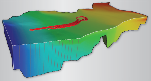
Ackerman Model Cover
A three-dimensional solid contour plot using a smooth coloring scheme to represent simulated steady-state hydraulic heads within model layers 3 through 6. Particle pathlines representing tritium movement from 1953 to 1968 are displayed as narrow tubes in model layers 1 and 2.
A three-dimensional solid contour plot using a smooth coloring scheme to represent simulated steady-state hydraulic heads within model layers 3 through 6. Particle pathlines representing tritium movement from 1953 to 1968 are displayed as narrow tubes in model layers 1 and 2.
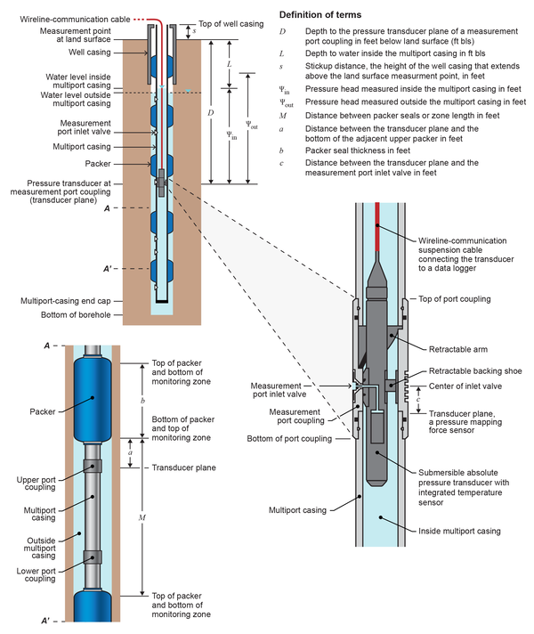
Multi-level Monitoring System
Terms used in the calculation of hydraulic head on the portable probe position when coupled with a measurement port in the multilevel monitoring system. (Modified from Westbay™, written commun., 2009.)
Terms used in the calculation of hydraulic head on the portable probe position when coupled with a measurement port in the multilevel monitoring system. (Modified from Westbay™, written commun., 2009.)

Dye tracer study on the Kootenai River
Aerial view of a USGS dye tracer study done on the Kootenai River in Idaho.
Aerial view of a USGS dye tracer study done on the Kootenai River in Idaho.

Panorama of Hailey, Idaho
Panoramic photograph of Hailey, Idaho, looking southeast from Carbonate Mountain.
Panoramic photograph of Hailey, Idaho, looking southeast from Carbonate Mountain.

Acoustic Doppler Velocity Meter
An acoustic Doppler velocity meter mounted on a track for instream deployment. The USGS deployed devices similar to this on at three monitoring sites on northern Idaho's Kootenai River to estimate sediment concentrations in the spawning habitat of the endangered Kootenai River white sturgeon.
An acoustic Doppler velocity meter mounted on a track for instream deployment. The USGS deployed devices similar to this on at three monitoring sites on northern Idaho's Kootenai River to estimate sediment concentrations in the spawning habitat of the endangered Kootenai River white sturgeon.

Researcher collects particle size analysis samples
Researcher collects particle size analysis samplesGary Barton (USGS) collects particle size analysis samples of the surface riverbed material of the Kootenai River about three miles upstream from Bonners Ferry, ID.
Researcher collects particle size analysis samples
Researcher collects particle size analysis samplesGary Barton (USGS) collects particle size analysis samples of the surface riverbed material of the Kootenai River about three miles upstream from Bonners Ferry, ID.

Particle size analysis of the surface riverbed material
Particle size analysis of the surface riverbed materialGary Barton (USGS) and Jeff Laufle (U.S. Army Corps of Engineers) carried out a particle size analysis of the surface riverbed material on the right bank (facing downstream) of the Snake River about three miles below Ice Harbor Dam near Burbank, WA.

Grays Lake Outlet near Herman, ID
Earlier this year, Congress provided $6 million in additional funding for the USGS National Streamflow Information Program (NSIP). This streamgage is one of 10 in Idaho now funded by NSIP.
Earlier this year, Congress provided $6 million in additional funding for the USGS National Streamflow Information Program (NSIP). This streamgage is one of 10 in Idaho now funded by NSIP.

Lapwai Creek near Lapwai, ID
Earlier this year, Congress provided $6 million in additional funding for the USGS National Streamflow Information Program (NSIP). This streamgage is one of 10 in Idaho now funded by NSIP.
Earlier this year, Congress provided $6 million in additional funding for the USGS National Streamflow Information Program (NSIP). This streamgage is one of 10 in Idaho now funded by NSIP.

Little Lost River near Howe, ID
Earlier this year, Congress provided $6 million in additional funding for the USGS National Streamflow Information Program (NSIP). This streamgage is one of 10 in Idaho now funded by NSIP.
Earlier this year, Congress provided $6 million in additional funding for the USGS National Streamflow Information Program (NSIP). This streamgage is one of 10 in Idaho now funded by NSIP.

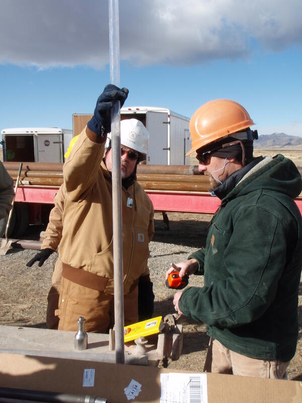
Owyhee Canyonlands Streamgage Installation
A rainbow arches over the Owyhee Canyonlands wilderness area at the site of USGS streamgage 13176400, East Fork Owyhee River at Crutcher Crossing, ID. The U.S. Bureau of Land Management will use data from this gage to secure water rights to protect Wild and Scenic Rivers in the wilderness.
A rainbow arches over the Owyhee Canyonlands wilderness area at the site of USGS streamgage 13176400, East Fork Owyhee River at Crutcher Crossing, ID. The U.S. Bureau of Land Management will use data from this gage to secure water rights to protect Wild and Scenic Rivers in the wilderness.

Owyhee Canyonlands Streamgage Installation
This new streamgage, USGS 13176400, East Fork Owyhee River at Crutcher Crossing, ID, will provide critical data the U.S. Bureau of Land Management needs to secure water rights to protect the Owyhee Canyonlands wilderness area.
This new streamgage, USGS 13176400, East Fork Owyhee River at Crutcher Crossing, ID, will provide critical data the U.S. Bureau of Land Management needs to secure water rights to protect the Owyhee Canyonlands wilderness area.

Snake River at King Hill, ID
Earlier this year, Congress provided $6 million in additional funding for the USGS National Streamflow Information Program (NSIP). This streamgage is one of 10 in Idaho now funded by NSIP.
Earlier this year, Congress provided $6 million in additional funding for the USGS National Streamflow Information Program (NSIP). This streamgage is one of 10 in Idaho now funded by NSIP.