
A USGS Hydrologic Technician collects eDNA samples alongside a stream in the Nevada wilderness
Images
Images intro.
Filter Total Items: 72

collecting eDNA samples
A USGS Hydrologic Technician collects eDNA samples alongside a stream in the Nevada wilderness
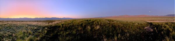
Fen in Big Smoky Valley
Photo of a fen, a small groundwater-fed wetland in desert environment that can provide habitat for plants and animals.
Photo of a fen, a small groundwater-fed wetland in desert environment that can provide habitat for plants and animals.

Carson River below Lahontan Reservoir near Fallon, NV
Carson River below Lahontan Reservoir near Fallon, NVView looking downstream of Lahontan Reservoir. Monitoring location USGS 10312150 Carson River below Lahontan Reservoir near Fallon, NV measures streamflow releases from Lahontan Dam.
Carson River below Lahontan Reservoir near Fallon, NV
Carson River below Lahontan Reservoir near Fallon, NVView looking downstream of Lahontan Reservoir. Monitoring location USGS 10312150 Carson River below Lahontan Reservoir near Fallon, NV measures streamflow releases from Lahontan Dam.

Wild horses in the Virginia City Highlands, Nev.
Wild horses in the Virginia City Highlands, Nev.
Wild horses in the Virginia City Highlands, Nev.

USGS Streamgaging Station in northern Nevada.
USGS Streamgaging Station in northern Nevada.
USGS Streamgaging Station in northern Nevada.

Measuring streamflow in northern Nevada.
USGS technician measuring streamflow in northern Nevada.
USGS technician measuring streamflow in northern Nevada.

Well pumping as part of an aquifer test in Lovelock Valley, Nevada
Well pumping as part of an aquifer test in Lovelock Valley, NevadaWell pumping as part of an aquifer test in Lovelock Valley, Nevada.
Well pumping as part of an aquifer test in Lovelock Valley, Nevada
Well pumping as part of an aquifer test in Lovelock Valley, NevadaWell pumping as part of an aquifer test in Lovelock Valley, Nevada.

USGS staff gage measuring the height of the water in the Carson River
USGS staff gage measuring the height of the water in the Carson RiverUSGS staff gage (ruler) measuring the height of the water, on the Carson River, near Brunswick Canyon, Nevada.
USGS staff gage measuring the height of the water in the Carson River
USGS staff gage measuring the height of the water in the Carson RiverUSGS staff gage (ruler) measuring the height of the water, on the Carson River, near Brunswick Canyon, Nevada.

Carson River Next to Morgan Mill Rd
Flood water on Carson River near Nevada Water Science Center Office.
Flood water on Carson River near Nevada Water Science Center Office.

Streamgaging on Martin Creek in Nevada
Streamgaging on Martin Creek, near Paradise Valley, Nevada.
Streamgaging on Martin Creek, near Paradise Valley, Nevada.

Acoustic Doppler Current Profiler
A U.S. Geological Survey field crew uses an Acoustic Doppler Current Profiler to measure water velocity on the Truckee River in Reno, Nevada.
A U.S. Geological Survey field crew uses an Acoustic Doppler Current Profiler to measure water velocity on the Truckee River in Reno, Nevada.

Flood in 2017 along Carson River, Nevada
Flood in 2017 along Carson River, Nevada.
Flood in 2017 along Carson River, Nevada.

Evapotranspiration stations at the Amargosa Desert Research Site, Nev.
Evapotranspiration stations at the Amargosa Desert Research Site, Nev.Evapotranspiration stations at the Amargosa Desert Research Site, Nevada.
Evapotranspiration stations at the Amargosa Desert Research Site, Nev.
Evapotranspiration stations at the Amargosa Desert Research Site, Nev.Evapotranspiration stations at the Amargosa Desert Research Site, Nevada.

Walker Lake
Walker Lake in Nevada on a Spring day
Walker Lake in Nevada on a Spring day

View of periphyton from the shoreline of Lake Tahoe
View of periphyton from the shoreline of Lake TahoeView of periphyton from the shoreline of Lake Tahoe.
View of periphyton from the shoreline of Lake Tahoe
View of periphyton from the shoreline of Lake TahoeView of periphyton from the shoreline of Lake Tahoe.

Periphyton growing on rocks along the shore of Lake Tahoe
Periphyton growing on rocks along the shore of Lake TahoePeriphyton growing on rocks along the shore of Lake Tahoe.
Periphyton growing on rocks along the shore of Lake Tahoe
Periphyton growing on rocks along the shore of Lake TahoePeriphyton growing on rocks along the shore of Lake Tahoe.

Close up view of periphyton on rocks along the shore of Lake Tahoe
Close up view of periphyton on rocks along the shore of Lake TahoeClose up view of periphyton on rocks along the shore of Lake Tahoe.
Close up view of periphyton on rocks along the shore of Lake Tahoe
Close up view of periphyton on rocks along the shore of Lake TahoeClose up view of periphyton on rocks along the shore of Lake Tahoe.

Periphyton growing on rocks along the shore of Lake Tahoe
Periphyton growing on rocks along the shore of Lake TahoePeriphyton growing on rocks along the shore of Lake Tahoe. White tubes were used for collecting water-quality samples as part of the Lake Tahoe Nearshore Periphyton Study.
Periphyton growing on rocks along the shore of Lake Tahoe
Periphyton growing on rocks along the shore of Lake TahoePeriphyton growing on rocks along the shore of Lake Tahoe. White tubes were used for collecting water-quality samples as part of the Lake Tahoe Nearshore Periphyton Study.

Winter squall at Lake Tahoe
Winter squall at Lake Tahoe
Winter squall at Lake Tahoe

Winter sunset at Lake Tahoe
Winter sunset at Lake Tahoe
Winter sunset at Lake Tahoe

Winter at Ward Creek, CA
Winter at Ward Creek, CA
Winter at Ward Creek, CA