
U.S. Geological Survey-U.S. Department of Energy Cooperative Studies
Lake Tahoe Hydro Mapper
Science in the Truckee River Basin
Science in the Carson River Basin
Nevada Water Science Center
The Nevada Water Science Center is committed to providing reliable and unbiased information on Nevada's water resources to the public, partners, and stakeholders. Our broad data collection network and research provide timely, useful information to keep the public informed, protect life and property, and improve our understanding of water supply and availability across Nevada and adjacent states.
National Water Dashboard
National Water Dashboard

See current streamflow, groundwater, and water-quality conditions with this new map interface to USGS data.
Featured Science
Featured Science
Learn about the latest USGS research in the Humboldt River Basin.
Quick Links
Quick Links
Get our most popular data:
News
Humboldt River Basin Capture Query Tool
Humboldt River Basin Capture Query Tool
2025 in Review: The Saline Lake Ecosystems Integrated Water Availability Assessment
2025 in Review: The Saline Lake Ecosystems Integrated Water Availability Assessment
USGS Water Science Centers Partner at 2025 Lake Tahoe Summit
USGS Water Science Centers Partner at 2025 Lake Tahoe Summit
Publications
Network-wide assessment of soil water content calibration and sensitivity to biomass proxies using cosmic-ray neutron sensing in the Roaring Fork Basin, Colorado Network-wide assessment of soil water content calibration and sensitivity to biomass proxies using cosmic-ray neutron sensing in the Roaring Fork Basin, Colorado
Soil water content (SWC) is a key state variable of the climate system but is often uncertain in water balance monitoring, especially in alpine environments. SWC measurements can be challenging in alpine environments due to the topography and rocky soils. In 2022, the US Geological Survey's Next Generation Water Observing System Program began research to evaluate water balance monitoring
Evaluation of stream capture related to groundwater pumping, middle Humboldt River Basin, Nevada Evaluation of stream capture related to groundwater pumping, middle Humboldt River Basin, Nevada
Historical, future, and potential stream capture from groundwater pumping in the middle Humboldt River Basin (MHRB), Nevada, is estimated using a calibrated numerical groundwater flow model. The model was developed to estimate (1) stream capture, which is the change in flux between the groundwater system and the Humboldt River and tributaries, and (2) change in streamflow, which is the...
Sediment accumulation rates and volume in Pahranagat Wash above Arrow Canyon Dam in northern Moapa Valley, Nevada Sediment accumulation rates and volume in Pahranagat Wash above Arrow Canyon Dam in northern Moapa Valley, Nevada
An evaluation of sediment deposition rates and volume of impounded sediments in Pahranagat Wash behind Arrow Canyon dam in southeastern Nevada was done between 2016 and 2022. Data were collected and interpreted to address concerns by the Moapa Band of Paiutes and local historical preservation groups regarding the burial of culturally important sites by the impounded sediment deposited...
Science
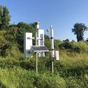
Next Generation Water Observing System (NGWOS) - Advancing Soil Moisture Monitoring
Soil moisture is an important part of the climate system, but it remains difficult to measure accurately. In 2022, the U.S. Geological Survey (USGS) began building a soil moisture monitoring network to provide high-quality continuous soil moisture data, standardize data collection methods, and test new technologies. Stations are placed in different climates and land cover types to capture a broad...

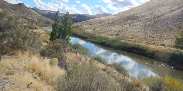
Science in the Humboldt River Basin
The Humboldt River flows east to west through north-central Nevada and is about 330 miles long. It is an important water source for residents and agriculture, and it also supports one of Nevada’s largest industries—gold mining. Most of the state’s mines are in the Humboldt River Basin along the Carlin Trend. Nevada produces about 72 percent of all U.S. gold, making it the fifth largest producer in...

Evaluation of Streamflow Depletion Related to Groundwater Withdrawal, Humboldt River Basin
This project evaluates how groundwater withdrawals affect streamflow in the Humboldt River Basin. It focuses on understanding the timing, magnitude, and causes of streamflow depletion, including agricultural pumping and mine dewatering, to support sustainable water management in Nevada.