
To better protect the City of Elizabeth’s residents and assets, the U.S. Geological Survey (USGS) and Rutgers University proposed a joint collaboration to develop a reliable flood risk management platform with the cooperation of the City of Elizabeth and the New Jersey Office of Emergency Management. Our understanding is the broader goal for the City of Elizabeth is to accomplish three primary objectives including an early flood warning system, provide inundation information to the City, State and the general public, and to potentially develop an internal operational flood warning model. These objectives will improve road closures and early evacuations for the protection of human life and property. The USGS study is one part of the overall multi-agency partnered approach to providing better information for protection from flooding.
Background
Remnants of Hurricane Ida produced extremely heavy rainfall rates across central and north-central New Jersey on September 1-2, 2021. The resulting flooding caused severe damage to roads, bridges and infrastructure. Statewide, 30 deaths were connected to flooding with 4 fatalities in the City of Elizabeth alone. In addition to the deaths, hundreds of water rescues were performed for people and vehicles caught in torrential flooding.
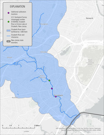
Many U.S. Geological Survey stream gages recorded new period-of-record peak stream flows including the Elizabeth River at Ursino Lake at Elizabeth stream gage which peaked at 27.93 feet. This new record peak exceeded the design criteria of the United States Army Corps of Engineers (USACE) flood mitigation project within the northern proximities of the City of Elizabeth causing floodwaters to route around the project and inundate adjacent neighborhoods.
Study Area
The study area for this project is the City of Elizabeth from its border with Hillsdale Township at North Avenue downstream along the Elizabeth River to its tidal confluence with the Arthur Kill. In order to adequately define the flooding characteristics within the City, the drainage basins for the Elizabeth River will also be included within the study area.
Data collection and synthesis
Evaluation of the study reach will be accomplished by construction and calibration of hydraulic models and rainfall runoff models. Construction of the hydraulic models necessary for the project involves collection and evaluation of existing data. Some of these data include pre-existing legacy models, digital elevation data, road and bridge information, dimensions, and elevations, drainage system information, dimensions and elevations, historical information on road flooding and closures, and precipitation data. Once assembled, the pre-existing data can be reviewed, and gaps identified.
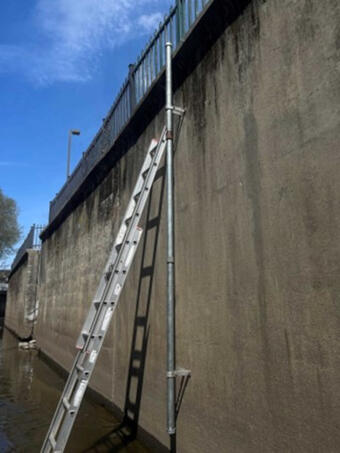
Field data collection to fill gaps includes collection of ground-truth structure dimensions, channel bathymetry, ground-truth bank elevations to quality-assure digital elevation data as well as discrete discharge measurements for aid in calibration of hydraulic models. Recording of peak elevations within the lower portion of the study reach will be accomplished using crest-stage gages installed at key locations.
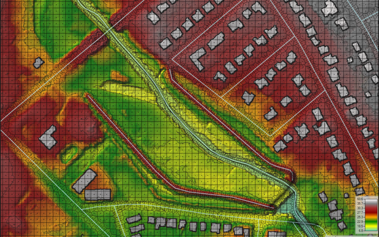
From the USGS, these data will be used to construct a two-dimensional hydraulic model within the Elizabeth River study reach using the U.S Army Corps of Engineers (USACE) Hydraulic Engineering Center’s River Analysis System software, or HEC-RAS. Precipitation will be directly applied to the two-dimensional model to general outputs of pluvial (from precipitation) and fluvial (from the river) flooding. The project is somewhat unique because it will attempt to integrate outputs from the City’s subterranean drainage system model constructed in the Environmental Protection Agency’s (EPA) StormWater Management Model (SWMM) to investigate areas where the drainage system might become overwhelmed by precipitation drainage and result in street and intersection flooding.
Several rainfall scenarios will be employed within the modeled study area. These scenarios will be a series of “localized” rainfall intensity curves that will be used within the two-dimensional model to generate hydrographs to be linked to the calibrated hydraulic models.
Rutgers University is building a parallel approach with an operational flood model with a variety of visual outputs to convey flood risk and warnings using their Flood Information Dashboard tool.
Evaluation of impact locations and display of inundation and impact layers.
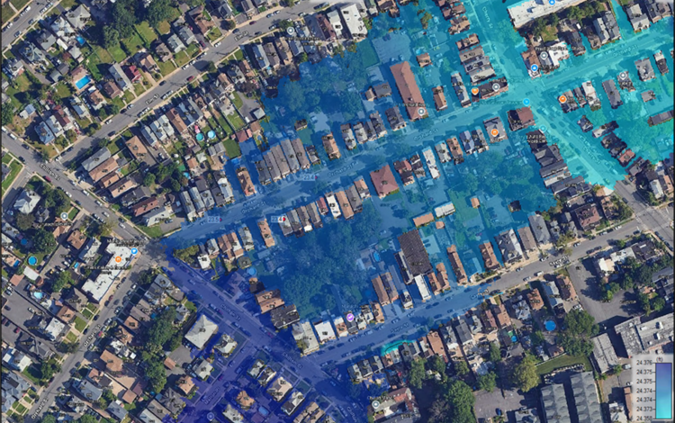
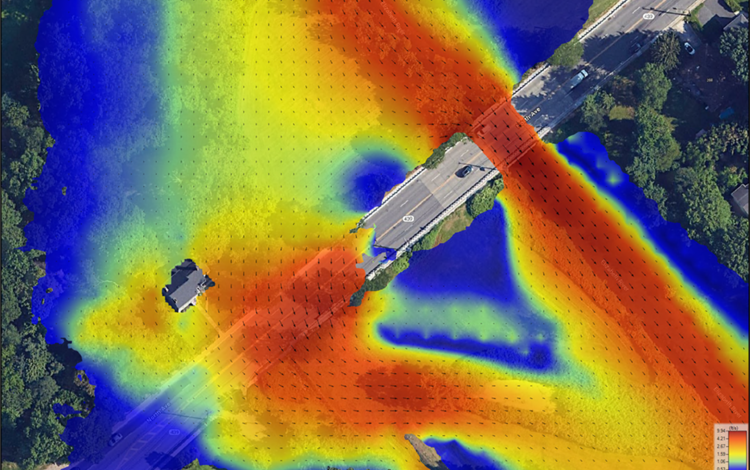
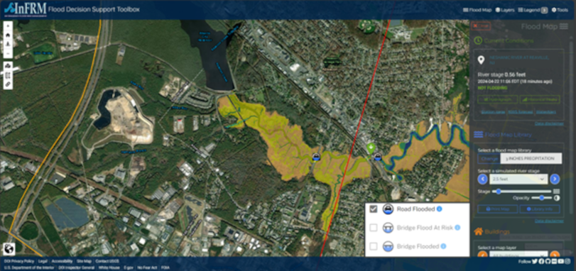
Model performance will be evaluated and compared to existing impacts obtained from local officials on road, bridges, critical structures such as fire and police stations, and areas within the City that have sustained frequent and historical damage from flooding. The completed flood inundation maps will be hosted using the New Jersey Flood Decision Support Toolbox (FDST) mapping application employing a custom interface for display of the rainfall scenarios “on top” of the selected river condition. Within the application, areas of increased critical hazards from both inundation depth and velocity on roadways may be highlighted to support early warning information for the protection of human life and property. In addition, buildings and structures may be color coded to display the level of impact.
Planned Project Outcomes
In addition to the mapping application available on the New Jersey FDST, the inundation layers for each reach will be available via a USGS Sciencebase data release. A summary of findings as well as a full description of model development and calibration will be available within a USGS Scientific Investigations Report (SIR). The inundation mapping and scenarios will be linked with the USGS Water Alert system for automated messaging to users when specific warning conditions are met, but also available for planning and mitigation strategies, as well as education and public outreach.
To better protect the City of Elizabeth’s residents and assets, the U.S. Geological Survey (USGS) and Rutgers University proposed a joint collaboration to develop a reliable flood risk management platform with the cooperation of the City of Elizabeth and the New Jersey Office of Emergency Management. Our understanding is the broader goal for the City of Elizabeth is to accomplish three primary objectives including an early flood warning system, provide inundation information to the City, State and the general public, and to potentially develop an internal operational flood warning model. These objectives will improve road closures and early evacuations for the protection of human life and property. The USGS study is one part of the overall multi-agency partnered approach to providing better information for protection from flooding.
Background
Remnants of Hurricane Ida produced extremely heavy rainfall rates across central and north-central New Jersey on September 1-2, 2021. The resulting flooding caused severe damage to roads, bridges and infrastructure. Statewide, 30 deaths were connected to flooding with 4 fatalities in the City of Elizabeth alone. In addition to the deaths, hundreds of water rescues were performed for people and vehicles caught in torrential flooding.
Many U.S. Geological Survey stream gages recorded new period-of-record peak stream flows including the Elizabeth River at Ursino Lake at Elizabeth stream gage which peaked at 27.93 feet. This new record peak exceeded the design criteria of the United States Army Corps of Engineers (USACE) flood mitigation project within the northern proximities of the City of Elizabeth causing floodwaters to route around the project and inundate adjacent neighborhoods.
Study Area
The study area for this project is the City of Elizabeth from its border with Hillsdale Township at North Avenue downstream along the Elizabeth River to its tidal confluence with the Arthur Kill. In order to adequately define the flooding characteristics within the City, the drainage basins for the Elizabeth River will also be included within the study area.
Data collection and synthesis
Evaluation of the study reach will be accomplished by construction and calibration of hydraulic models and rainfall runoff models. Construction of the hydraulic models necessary for the project involves collection and evaluation of existing data. Some of these data include pre-existing legacy models, digital elevation data, road and bridge information, dimensions, and elevations, drainage system information, dimensions and elevations, historical information on road flooding and closures, and precipitation data. Once assembled, the pre-existing data can be reviewed, and gaps identified.
Field data collection to fill gaps includes collection of ground-truth structure dimensions, channel bathymetry, ground-truth bank elevations to quality-assure digital elevation data as well as discrete discharge measurements for aid in calibration of hydraulic models. Recording of peak elevations within the lower portion of the study reach will be accomplished using crest-stage gages installed at key locations.
From the USGS, these data will be used to construct a two-dimensional hydraulic model within the Elizabeth River study reach using the U.S Army Corps of Engineers (USACE) Hydraulic Engineering Center’s River Analysis System software, or HEC-RAS. Precipitation will be directly applied to the two-dimensional model to general outputs of pluvial (from precipitation) and fluvial (from the river) flooding. The project is somewhat unique because it will attempt to integrate outputs from the City’s subterranean drainage system model constructed in the Environmental Protection Agency’s (EPA) StormWater Management Model (SWMM) to investigate areas where the drainage system might become overwhelmed by precipitation drainage and result in street and intersection flooding.
Several rainfall scenarios will be employed within the modeled study area. These scenarios will be a series of “localized” rainfall intensity curves that will be used within the two-dimensional model to generate hydrographs to be linked to the calibrated hydraulic models.
Rutgers University is building a parallel approach with an operational flood model with a variety of visual outputs to convey flood risk and warnings using their Flood Information Dashboard tool.
Evaluation of impact locations and display of inundation and impact layers.
Model performance will be evaluated and compared to existing impacts obtained from local officials on road, bridges, critical structures such as fire and police stations, and areas within the City that have sustained frequent and historical damage from flooding. The completed flood inundation maps will be hosted using the New Jersey Flood Decision Support Toolbox (FDST) mapping application employing a custom interface for display of the rainfall scenarios “on top” of the selected river condition. Within the application, areas of increased critical hazards from both inundation depth and velocity on roadways may be highlighted to support early warning information for the protection of human life and property. In addition, buildings and structures may be color coded to display the level of impact.
Planned Project Outcomes
In addition to the mapping application available on the New Jersey FDST, the inundation layers for each reach will be available via a USGS Sciencebase data release. A summary of findings as well as a full description of model development and calibration will be available within a USGS Scientific Investigations Report (SIR). The inundation mapping and scenarios will be linked with the USGS Water Alert system for automated messaging to users when specific warning conditions are met, but also available for planning and mitigation strategies, as well as education and public outreach.