
Hurricane Sandy Science, Ten-years Later
On October 29, 2012, Hurricane Sandy made landfall in New Jersey after several days of impacting the Atlantic coastline. Ten years later the impacted communities have recovered and rebuilt, and the New Jersey Water Science Center has expanded its scientific understanding of storm impacts on our state.
Hurricane Sandy was one of the most destructive hurricanes in U.S. history and had grown into the largest hurricane ever recorded in the North Atlantic before making landfall along the coast of New Jersey in 2012. The New Jersey coast consists of barrier islands - narrow stretches of sand deposited parallel to the mainland coast – that were deeply eroded, overwashed, and in places breached by the storm. A USGS science plan was developed immediately following Hurricane Sandy to improve the auxiliary sensor deployment strategy for extreme coastal storms. The NJWSC also implemented a plan to upgrade the existing USGS New Jersey Tide Network (NJTN), a network of real-time tide gages and weather stations that monitor the back bays to withstand storm surge conditions from major coastal storms to better inform emergency managers and local communities about tidal conditions during a storm.
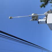
Ten years later, the USGS NJTN has been upgraded with primary sensors elevated on raised platforms, and secondary sensors installed as backup to minimize chances of missing data during a major coastal storm event. Meteorological sensors were also added to the NJTN to provide real-time rainfall, wind speed and wind direction data during major storms. These upgrades were implemented in a collaborative way using federal funding for structural improvements and cooperative agreements with the NJ Dept. of Environmental Protection and NJ Office of Emergency Management for secondary sensor and meteorological sensor upgrades. These combined improvements were implemented to provide better information about local storm conditions and minimize the potential of data loss or tide gage damage during the next major coastal storm.


The science plan, implemented in the wake of Hurricane Sandy, included the construction of an overland Surge, Wave, and Tide Hydrodynamics (SWaTH) Network along the Northeastern Atlantic Coast to improve auxiliary sensor deployments ahead on the next major storm. In New Jersey, the SWaTH Network has been added to the existing flood-hardened, long-term, real-time tide gages, enhancing them with real-time rapid-deployment gages (RDGs), and temporary storm-tide sensors (STS). Equipment housings optimized for rapid deployment along the coastline to capture the tidal cycle will enable scientists to measure and analyze collected data to calculate tidal water-levels in many more locations and wave statistics like wave-height, frequency, and period to better understand the inundation from the storm and the wave forces that impacted and potentially caused damage to local structures. Additionally, the New Jersey Water Science Center is testing new sensor and camera technologies to amplify scientists’ understanding of these dynamic and destructive events.

Coastal hydrodynamic models have been developed and improved with data collected from Hurricane Sandy and subsequent coastal storms. Models such as these, employing storm-forces such as wind and surge, are being used to develop flood-inundation maps with coverage spanning the entire coast of New Jersey. This soon-to-be released tool will provide emergency management personnel and residents with a link between numeric and text warning information and images of estimated inundation extents in their communities. User selected display of inundation will allow early response activities to forecasted water level elevations or mitigation planning by selecting targeted water levels and planning critical pre-flood activities such as building elevations, early traffic pattern changes because of neighborhood building inundation levels, improved understanding about when major road access is affected, as well as for post-flood recovery efforts.
When Hurricane Sandy made landfall on the barrier islands near Brigantine, New Jersey, it not only devastated communities but habitats along the Edwin B. Forsythe National Wildlife Refuge. With the assistance of the U.S. Fish and Wildlife Service, a study of the barrier islands and the estuaries behind them was begun to better understand and map the groundwater table which feeds these valuable ecosystems, beaches, and marshes. The ability of barrier island systems to recover and maintain themselves from storm impacts and sea-level rise (SLR), is important for the management of the ecological resources of the refuge.
In Sandy Hook, Old-growth maritime forests such as the Bayshore Holly Maritime Forest are threatened by sea-level rise (SLR) and potential increased storm frequency and intensity. Following Hurricane Sandy, the Bayshore Holly Maritime Forest suffered mortality in low-lying areas that were inundated by storm waters. Subsequent studies at Sandy Hook, NJ, Fire Island, NY and Assateague, MD were designed to test this hypothesis by compiling and analyzing water level and salinity data collected in near shore and inland wells during storm events.
Ten years ago, Hurricane Sandy devastated the coast of New Jersey breaking through the barrier islands at Mantoloking and damaging and destroying much of our coastal Tide Network. Ten years later, we have learned from the lessons of this storm and expanded our understanding of coastal science. Hurricane Sandy may have caused a great deal of devastation, but the New Jersey Water Science Center has grown from it, strengthening our operation and our bonds with local and national partners, to be better prepared for the future needs of our community.
New Jersey Precipitation and Weather Networks

Sandy Hook

Forsythe

New Jersey Coastal Surge, Wave, and Tide Hydrodynamics Network (SWaTH)

Sandy Hook Gateway National Recreation Area Study

Hurricanes and Storm-Tide Monitoring

Hurricane Sandy Science
On October 29, 2012, Hurricane Sandy made landfall in New Jersey after several days of impacting the Atlantic coastline. Ten years later the impacted communities have recovered and rebuilt, and the New Jersey Water Science Center has expanded its scientific understanding of storm impacts on our state.
Hurricane Sandy was one of the most destructive hurricanes in U.S. history and had grown into the largest hurricane ever recorded in the North Atlantic before making landfall along the coast of New Jersey in 2012. The New Jersey coast consists of barrier islands - narrow stretches of sand deposited parallel to the mainland coast – that were deeply eroded, overwashed, and in places breached by the storm. A USGS science plan was developed immediately following Hurricane Sandy to improve the auxiliary sensor deployment strategy for extreme coastal storms. The NJWSC also implemented a plan to upgrade the existing USGS New Jersey Tide Network (NJTN), a network of real-time tide gages and weather stations that monitor the back bays to withstand storm surge conditions from major coastal storms to better inform emergency managers and local communities about tidal conditions during a storm.
Ten years later, the USGS NJTN has been upgraded with primary sensors elevated on raised platforms, and secondary sensors installed as backup to minimize chances of missing data during a major coastal storm event. Meteorological sensors were also added to the NJTN to provide real-time rainfall, wind speed and wind direction data during major storms. These upgrades were implemented in a collaborative way using federal funding for structural improvements and cooperative agreements with the NJ Dept. of Environmental Protection and NJ Office of Emergency Management for secondary sensor and meteorological sensor upgrades. These combined improvements were implemented to provide better information about local storm conditions and minimize the potential of data loss or tide gage damage during the next major coastal storm.
The science plan, implemented in the wake of Hurricane Sandy, included the construction of an overland Surge, Wave, and Tide Hydrodynamics (SWaTH) Network along the Northeastern Atlantic Coast to improve auxiliary sensor deployments ahead on the next major storm. In New Jersey, the SWaTH Network has been added to the existing flood-hardened, long-term, real-time tide gages, enhancing them with real-time rapid-deployment gages (RDGs), and temporary storm-tide sensors (STS). Equipment housings optimized for rapid deployment along the coastline to capture the tidal cycle will enable scientists to measure and analyze collected data to calculate tidal water-levels in many more locations and wave statistics like wave-height, frequency, and period to better understand the inundation from the storm and the wave forces that impacted and potentially caused damage to local structures. Additionally, the New Jersey Water Science Center is testing new sensor and camera technologies to amplify scientists’ understanding of these dynamic and destructive events.
Coastal hydrodynamic models have been developed and improved with data collected from Hurricane Sandy and subsequent coastal storms. Models such as these, employing storm-forces such as wind and surge, are being used to develop flood-inundation maps with coverage spanning the entire coast of New Jersey. This soon-to-be released tool will provide emergency management personnel and residents with a link between numeric and text warning information and images of estimated inundation extents in their communities. User selected display of inundation will allow early response activities to forecasted water level elevations or mitigation planning by selecting targeted water levels and planning critical pre-flood activities such as building elevations, early traffic pattern changes because of neighborhood building inundation levels, improved understanding about when major road access is affected, as well as for post-flood recovery efforts.
When Hurricane Sandy made landfall on the barrier islands near Brigantine, New Jersey, it not only devastated communities but habitats along the Edwin B. Forsythe National Wildlife Refuge. With the assistance of the U.S. Fish and Wildlife Service, a study of the barrier islands and the estuaries behind them was begun to better understand and map the groundwater table which feeds these valuable ecosystems, beaches, and marshes. The ability of barrier island systems to recover and maintain themselves from storm impacts and sea-level rise (SLR), is important for the management of the ecological resources of the refuge.
In Sandy Hook, Old-growth maritime forests such as the Bayshore Holly Maritime Forest are threatened by sea-level rise (SLR) and potential increased storm frequency and intensity. Following Hurricane Sandy, the Bayshore Holly Maritime Forest suffered mortality in low-lying areas that were inundated by storm waters. Subsequent studies at Sandy Hook, NJ, Fire Island, NY and Assateague, MD were designed to test this hypothesis by compiling and analyzing water level and salinity data collected in near shore and inland wells during storm events.
Ten years ago, Hurricane Sandy devastated the coast of New Jersey breaking through the barrier islands at Mantoloking and damaging and destroying much of our coastal Tide Network. Ten years later, we have learned from the lessons of this storm and expanded our understanding of coastal science. Hurricane Sandy may have caused a great deal of devastation, but the New Jersey Water Science Center has grown from it, strengthening our operation and our bonds with local and national partners, to be better prepared for the future needs of our community.
New Jersey Precipitation and Weather Networks
Sandy Hook
Forsythe
New Jersey Coastal Surge, Wave, and Tide Hydrodynamics Network (SWaTH)
Sandy Hook Gateway National Recreation Area Study
Hurricanes and Storm-Tide Monitoring