
Coastal Plain and Unconsolidated Aquifers
Coastal Plain and Unconsolidated Aquifers
Filter Total Items: 35

Coastal Plain Chloride Network
Chloride levels in groundwater are measured in selected wells on a 5‑year cycle to provide early warning of saltwater intrusion and to delineate the 250 mg/L line of equal chloride concentration within the principal aquifers of the New Jersey Coastal Plain.

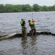
Long-term Water Monitoring Networks in New Jersey
The accurate, long-term monitoring networks of New Jersey Water Science Center provide valuable data in real-time and historical perspective to compare that data to. The longer a monitoring location is in operation, the more valuable it becomes, since more statistical comparisons can be performed. Our field technicians continuously make field measurements and maintain these networks.

New Jersey Coastal Plain Model
Updates to the Regional Groundwater-Flow Model of the New Jersey Coastal Plain, 1980-2013
Novel Bacterial Monitoring of Urbanized Waterways in the Lower Delaware River and Passaic River Basins.
As part of the Urban Water Federal Partnership, the U.S. Geological Survey (USGS) New Jersey Water Science Center (NJWSC) is currently assessing the use of innovative, near real-time bacteria monitoring technology to provide rapid results on bacteria concentrations to water regulators. Traditional methods of collecting and quantifying fecal indicator bacteria (FIB) is labor intensive, expensive...

New Jersey: Coastal Flood Inundation Mapping
The U.S. Geological Survey (USGS) in cooperation with the New Jersey Department of Environmental Protection and New Jersey Office of Emergency Management conducted a study to produce flood-inundation maps for storm surge flooding scenarios in the coastal areas of 10 New Jersey counties. The coastal storm-surge inundation maps were created from data modelled in the FEMA Region II Coastal Storm...

Program to Maintain and Update Groundwater Models
The Model Maintenance program, in cooperation with the N.J. Department of Environmental Protection (NJDEP), archives, maintains, updates, and shares groundwater-flow models that have been developed by the New Jersey Water Science Center (NJWSC). The program was started in 1995 to maintain existing groundwater flow models, use standardized procedures to archive the models, update models with recent...

Monitoring Harmful Algal Blooms in a Coastal System to Identify the Factors that Affect HAB Production and the Downstream Transport of Cyanobacteria and Associated Cyanotoxins from Freshwater to Marine Environments
Across the nation, Cyanobacterial harmful algal blooms (HABs) in freshwater coastal lakes and ponds have become a major environmental and public health concern. Under the right conditions, cyanobacteria can produce cyanotoxins that can pose health risks to both animals and humans (U.S. Environmental Protection Agency (USEPA), 2020) and have been shown to have severe impacts on water quality...

Investigations and Technical Assistance to the Joint Base McGuire-Dix-Lakehurst, New Jersey, in Assessing the Distribution and Transport of Perfluorinated Compounds in Groundwater and Surface Water
The USGS New Jersey Water Science Center provides hydrologic technical assistance to the U.S. Air Force Civil Engineer Center at Joint Base McGuire-Dix-Lakehurst (JBMDL) in New Jersey, regarding contamination issues associated with perfluoroalkyl substances (PFAS), such as perfluorooctanesulfonic acid (PFOS) and perfluorooctanoic acid (PFOA), in groundwater and surface water.

Hurricane Sandy Science, Ten-years Later
On October 29, 2012, Hurricane Sandy made landfall in New Jersey after several days of impacting the Atlantic coastline. Ten years later the impacted communities have recovered and rebuilt, and the New Jersey Water Science Center has expanded its scientific understanding of storm impacts on our state.

New Jersey Coastal Surge, Wave, and Tide Hydrodynamics Network (SWaTH)
Following Hurricane Sandy, the USGS began construction of an overland Surge, Wave, and Tide Hydrodynamics (SWaTH) Network along the Northeastern Atlantic Coast from North Carolina to Maine. This network, developed collaboratively with numerous partners, features the integration of long-term tide gage networks, with real-time rapid-deployment gages (RDG) and mobile storm-tide sensors (STS). An...

Sandy Hook Gateway National Recreation Area Study
The Sandy Hook Unit, Gateway National Recreation Area (hereafter Sandy Hook) in New Jersey is a 10-kilometer-long spit visited by thousands of people each year who take advantage of the historical and natural resources and recreational opportunities.

The Health of Maritime Forests in Three Mid-Atlantic National Seashores
The National Resources Protection Program (NRPP) project on Fire Island, Sandy Hook, and Assateague included a description of the issues and implications; description of the methods; and summary of the tasks, including site selection, well and instrumentation installation, and monitoring groundwater levels, temperature, and specific conductance, needed to understand the impact of global climate...