
Long-term Water Monitoring Networks in New Jersey
The accurate, long-term monitoring networks of New Jersey Water Science Center provide valuable data in real-time and historical perspective to compare that data to. The longer a monitoring location is in operation, the more valuable it becomes, since more statistical comparisons can be performed. Our field technicians continuously make field measurements and maintain these networks.
New Jersey Current Water Conditions

Real-time New Jersey Streamflow, Groundwater, and Water-quality conditions available through the National Water Data Dashboard interactive map application.
Real-Time Data for New Jersey

Current Water Data for New Jersey Streamflow, Groundwater, and Water-quality and other conditions.
How does Ice on Rivers and Streams Affect USGS Streamflow Data
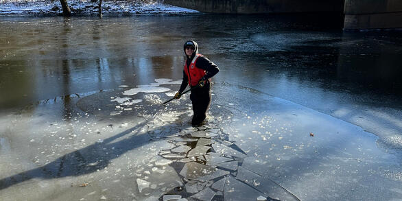
During colder winter periods ice can form in rivers and streams altering the natural relationship between stage and discharge (flow).
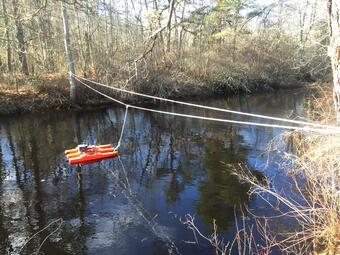
Streamgaging Network
Discharge data are crucial for modeling, forecasting, and statistical analysis. These data help properly size a culvert, determine how high a bridge must be to withstand high waters, allow water resource engineers to manage a basin’s water supply, and forecasters predict flood crests.
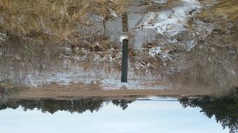
Groundwater Network
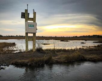
Groundwater Levels provide indicators of available water supplies and drought resiliency.
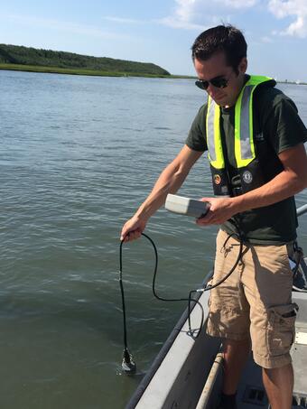
Water-quality Network
Both discrete (single point) and continuously collected, allow for analysis of constituent loadings (how much?), effects of land use change on our rivers, and detection of spills and pollutants in our waterways and aquifers.
- Real-time Water Quality Monitors
- Ambient Surface-Water-Quality Monitoring Network
- Ambient Groundwater-Quality Monitoring Network
Tide Network
The Tidal Network provides data to assist with forecasting, statistical analysis, and storm preparation done by our cooperators.
- Real-Time Tide Data
- New Jersey SWaTH (Coastal Surge, Wave, and Tide Hydrodynamics Network)
Precipitation and Weather Networks
Provides data augmentation to many locations for: Precipitation, Water and Air Temperature, and even Wind speed and direction at some of our coastal sites.
New Jersey Imagery Network
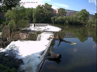
Static webcams have been installed at many of our real-time stream-gaging locations to allow you to view the current river-stage conditions as part of the National Hydrologic Imagery Visualization and Information System (HIVIS).
______
National Data
- Water Data for the Nation
- Annual Water Data Reports
- Water Year Summaries (2006 to Present)
- Water Data Reports (Pubs Warehouse pre 2005)
Below are other science projects associated with this project.

The New Jersey Streamgaging Network

New Jersey Groundwater Network

New Jersey Ambient Groundwater-Quality Monitoring Network

New Jersey Ambient Surface-Water-Quality Monitoring Network
The accurate, long-term monitoring networks of New Jersey Water Science Center provide valuable data in real-time and historical perspective to compare that data to. The longer a monitoring location is in operation, the more valuable it becomes, since more statistical comparisons can be performed. Our field technicians continuously make field measurements and maintain these networks.
New Jersey Current Water Conditions
Real-time New Jersey Streamflow, Groundwater, and Water-quality conditions available through the National Water Data Dashboard interactive map application.
Real-Time Data for New Jersey
Current Water Data for New Jersey Streamflow, Groundwater, and Water-quality and other conditions.
How does Ice on Rivers and Streams Affect USGS Streamflow Data
During colder winter periods ice can form in rivers and streams altering the natural relationship between stage and discharge (flow).
Streamgaging Network
Discharge data are crucial for modeling, forecasting, and statistical analysis. These data help properly size a culvert, determine how high a bridge must be to withstand high waters, allow water resource engineers to manage a basin’s water supply, and forecasters predict flood crests.
Groundwater Network
Groundwater Levels provide indicators of available water supplies and drought resiliency.
Water-quality Network
Both discrete (single point) and continuously collected, allow for analysis of constituent loadings (how much?), effects of land use change on our rivers, and detection of spills and pollutants in our waterways and aquifers.
- Real-time Water Quality Monitors
- Ambient Surface-Water-Quality Monitoring Network
- Ambient Groundwater-Quality Monitoring Network
Tide Network
The Tidal Network provides data to assist with forecasting, statistical analysis, and storm preparation done by our cooperators.
- Real-Time Tide Data
- New Jersey SWaTH (Coastal Surge, Wave, and Tide Hydrodynamics Network)
Precipitation and Weather Networks
Provides data augmentation to many locations for: Precipitation, Water and Air Temperature, and even Wind speed and direction at some of our coastal sites.
New Jersey Imagery Network
Static webcams have been installed at many of our real-time stream-gaging locations to allow you to view the current river-stage conditions as part of the National Hydrologic Imagery Visualization and Information System (HIVIS).
______
National Data
- Water Data for the Nation
- Annual Water Data Reports
- Water Year Summaries (2006 to Present)
- Water Data Reports (Pubs Warehouse pre 2005)
Below are other science projects associated with this project.
The New Jersey Streamgaging Network
New Jersey Groundwater Network
New Jersey Ambient Groundwater-Quality Monitoring Network