
Maps
Potential Radon Exposure
Radon Occurrence in Groundwater from 16 Geologic Units in Pennsylvania, 1986–2015, & Potential Radon Exposure from Groundwater and Indoor Air
Radon Occurrence in Groundwater from 16 Geologic Units in Pennsylvania, 1986–2015, & Potential Radon Exposure from Groundwater and Indoor Air
Groundwater Recharge
Completed USGS studies provide estimates of groundwater recharge in Pennsylvania and methods for estimating recharge in humid regions.
Completed USGS studies provide estimates of groundwater recharge in Pennsylvania and methods for estimating recharge in humid regions.
Maps are vital to displaying and disseminating our data and investigative findings. Our staff work on a diverse range of products built on a foundation of spatial data. We collect environmental data on the landscape and maps provide the geographic reference.
Many of our maps are published in USGS report series.
Latest Map
Latest Map
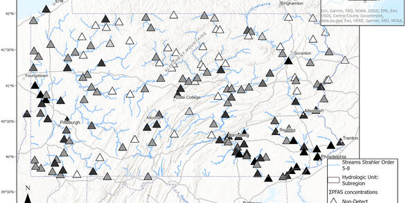
Water samples from 161 Pennsylvania rivers and streams were tested for 33 different per- and polyfluoroalkyl substances and 76% of the studied streams contained at least one of these chemicals, also knowns as PFAS.
Selected National and Regional Maps
Selected National and Regional Maps