
USGS science supporting the Elwha River Restoration Project
Geonarrative Explores Elwha River Restoration, Ten Years On
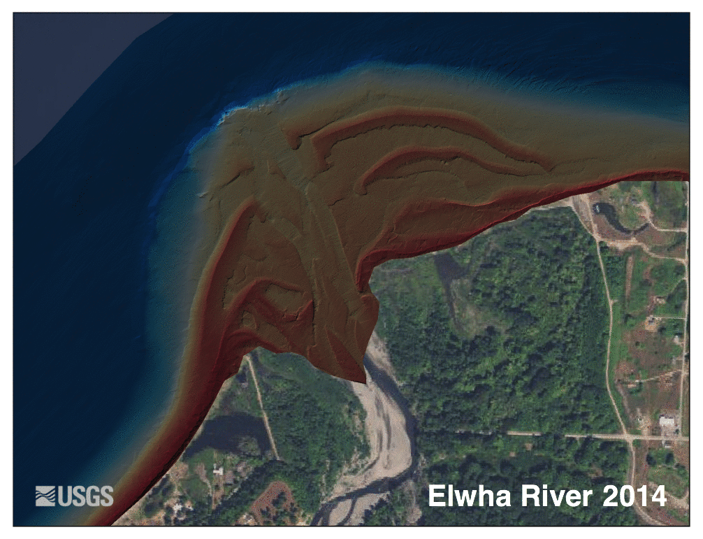
Mouth of the Elwha River
Former Lake Aldwell
and former site of Elwha Dam
Former Lake Mills
and former site of Glines Canyon Dam
Elwha River sediment plume
during dam removal
Mapping Elwha delta and environs
The Elwha River Restoration Project has reconnected the water, salmon, and sediment of a pristine river and coast of the Olympic Peninsula of Washington.
Coordinated by the National Park Service, restoration of the Elwha River included the removal of two large dams that had blocked salmon and sediment passage for almost 100 years. The largest dam removal in U.S. history began in September 2011 and concluded in the summer of 2014. Salmon are once again spawning in pristine river habitats of the Olympic National Park, and sediment is once again flowing down the river and to the eroding shoreline.

From 2011 to 2014, the Nation’s largest dam removal project to date took place in Washington State, allowing the Elwha River to once again flow unimpeded from its origin in the Olympic Mountains to the Strait of Juan de Fuca. Nearly 100 years of sediment (30 million tons) had accumulated behind two dams, and about two-thirds of that (20 million tons) was released, dramatically affecting the river channel, surrounding estuaries, beaches, and the river mouth. USGS expertise focused on understanding and measuring the physical and ecological impacts of dam removal and recovery of this river system alongside multiple partners: Olympic National Park, Lower Elwha Klallam Tribe, Bureau of Reclamation, Washington Department of Ecology, U.S. Fish and Wildlife Service, Environmental Protection Agency, National Ocean.

The USGS Pacific Coastal and Marine Science Center's (PCMSC) diverse suite of data acquisition and analytical tools, as well as expertise, were utilized to assess the progress of the restoration project and to quickly adapt to changing circumstances. The PCMSC mapped the river mouth and seafloor before and after dam removal, and collected water and sediment samples to measure nutrients and other indicators of ecosystem health. Instruments placed on the seafloor near the river mouth measured current velocity, salinity, temperature, light levels, and the amount of sediment suspended in the water. Underwater cameras took photographs periodically to document the changing seafloor environment. Lidar technology recorded landscape changes resulting from the new sediment deposited along the river and the coast. Scuba divers surveyed marine life and habitats near the mouth of the river to evaluate the effects of the high sediment loads.

Before dam removal, the river and coast downstream were starved of sand and gravel essential to the ecosystem that, according to tribal oral histories, formerly supported abundant shellfish. After dam removal, sand started accumulating again along these coastal habitats, helping to reverse long-term erosion. Salmon have begun to recolonize newly available river habitat upstream from both of the former dam sites. The Lower Elwha Klallam Tribe, whose creation site had been submerged since the building of the dams, has now had this culturally significant land returned to them. These are only a few of the ways in which this restoration project has impacted the lives of Washington residents and visitors.
The information gleaned and lessons learned from the extensive study of the Elwha River will inform decision-making for future dam decommissioning projects. This integration was facilitated through a USGS Powell Center working group on dam removal (2014–2015) that incorporated experiences and results from dozens of small and large dam removals into a better understanding of the effects of dam deconstruction. From this work we will be better able to predict the effects of dam removal on the landscape, wildlife, and communities, and how to best engineer these projects for the safety and well-being of local communities and their natural resources.


The Elwha River Restoration Project has reconnected the water, salmon, and sediment of a pristine river and coast of the Olympic Peninsula of Washington.
Coordinated by the National Park Service, restoration of the Elwha River included the removal of two large dams that had blocked salmon and sediment passage for almost 100 years. The largest dam removal in U.S. history began in September 2011 and concluded in the summer of 2014. Salmon are once again spawning in pristine river habitats of the Olympic National Park, and sediment is once again flowing down the river and to the eroding shoreline.
From 2011 to 2014, the Nation’s largest dam removal project to date took place in Washington State, allowing the Elwha River to once again flow unimpeded from its origin in the Olympic Mountains to the Strait of Juan de Fuca. Nearly 100 years of sediment (30 million tons) had accumulated behind two dams, and about two-thirds of that (20 million tons) was released, dramatically affecting the river channel, surrounding estuaries, beaches, and the river mouth. USGS expertise focused on understanding and measuring the physical and ecological impacts of dam removal and recovery of this river system alongside multiple partners: Olympic National Park, Lower Elwha Klallam Tribe, Bureau of Reclamation, Washington Department of Ecology, U.S. Fish and Wildlife Service, Environmental Protection Agency, National Ocean.
The USGS Pacific Coastal and Marine Science Center's (PCMSC) diverse suite of data acquisition and analytical tools, as well as expertise, were utilized to assess the progress of the restoration project and to quickly adapt to changing circumstances. The PCMSC mapped the river mouth and seafloor before and after dam removal, and collected water and sediment samples to measure nutrients and other indicators of ecosystem health. Instruments placed on the seafloor near the river mouth measured current velocity, salinity, temperature, light levels, and the amount of sediment suspended in the water. Underwater cameras took photographs periodically to document the changing seafloor environment. Lidar technology recorded landscape changes resulting from the new sediment deposited along the river and the coast. Scuba divers surveyed marine life and habitats near the mouth of the river to evaluate the effects of the high sediment loads.
Before dam removal, the river and coast downstream were starved of sand and gravel essential to the ecosystem that, according to tribal oral histories, formerly supported abundant shellfish. After dam removal, sand started accumulating again along these coastal habitats, helping to reverse long-term erosion. Salmon have begun to recolonize newly available river habitat upstream from both of the former dam sites. The Lower Elwha Klallam Tribe, whose creation site had been submerged since the building of the dams, has now had this culturally significant land returned to them. These are only a few of the ways in which this restoration project has impacted the lives of Washington residents and visitors.
The information gleaned and lessons learned from the extensive study of the Elwha River will inform decision-making for future dam decommissioning projects. This integration was facilitated through a USGS Powell Center working group on dam removal (2014–2015) that incorporated experiences and results from dozens of small and large dam removals into a better understanding of the effects of dam deconstruction. From this work we will be better able to predict the effects of dam removal on the landscape, wildlife, and communities, and how to best engineer these projects for the safety and well-being of local communities and their natural resources.