
Using Video Imagery to Study Wave Dynamics: Tres Palmas
To study wave dynamics along an active coastline, video cameras were installed on the west coast of Puerto Rico at Tres Palmas in Rincón.
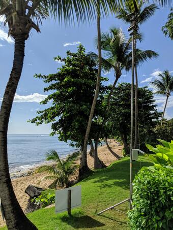
Every half hour during daylight hours, the cameras collected snapshots and video for 10 minutes. USGS scientists designed the station to measure wave run-up and flooding along Rincón. It was part of a study funded by USGS in response to Hurricanes Irma and Maria. USGS partnered with the University of Puerto Rico-Mayaguez (UPR-M) to better understand how waves propagate across coral reefs and cause coastal flooding along tropical shorelines. Their goal is to reduce hazards to, and increase the resilience of, tropical coastal communities. UPR-M will use the findings to improve coastal hazard forecasts they provide with data from NOAA’s Caribbean Coastal Ocean Observing System (CariCOOS).
The knowledge gained from these coastal camera studies will improve computer-derived simulations of coastal flooding and shoreline change that communities can use to plan for sea-level rise, changing storm patterns, and other threats to coasts.

Below are the projects that use the data collected by the video cameras, as well as other locations where similar video cameras are or were previously installed.

Coral Reef Project

Using Video Imagery to Study Wave Dynamics: Isla Verde
To study wave dynamics along an active coastline, video cameras were installed on the west coast of Puerto Rico at Tres Palmas in Rincón.
Every half hour during daylight hours, the cameras collected snapshots and video for 10 minutes. USGS scientists designed the station to measure wave run-up and flooding along Rincón. It was part of a study funded by USGS in response to Hurricanes Irma and Maria. USGS partnered with the University of Puerto Rico-Mayaguez (UPR-M) to better understand how waves propagate across coral reefs and cause coastal flooding along tropical shorelines. Their goal is to reduce hazards to, and increase the resilience of, tropical coastal communities. UPR-M will use the findings to improve coastal hazard forecasts they provide with data from NOAA’s Caribbean Coastal Ocean Observing System (CariCOOS).
The knowledge gained from these coastal camera studies will improve computer-derived simulations of coastal flooding and shoreline change that communities can use to plan for sea-level rise, changing storm patterns, and other threats to coasts.
Below are the projects that use the data collected by the video cameras, as well as other locations where similar video cameras are or were previously installed.
Coral Reef Project