Explore the fascinating undersea world of coral reefs. Learn how we map, monitor, and model coral reefs so we can better understand, protect, and preserve our Nation's reefs.
Coral reefs are unique ecosystems of plants, animals, and their associated geological framework. Coral reefs cover less than 0.5 percent of the earth's surface, but are home to an estimated 25 percent of all marine species. Second only to tropical rainforests in size and complexity, some scientists estimate that more than one million species of plants and animals are associated with coral reefs. Coral reefs are also of great economic importance to those who live on or visit islands in the Pacific and Atlantic Oceans. Reefs shelter and provide nursery grounds for many commercially and culturally important species of fish and invertebrates, they protect the islands' harbors, beaches, and shorelines from erosion and wave damage by storms, and they are vital to the marine tourism industry. These diverse ecosystems provide valuable goods and services worth about $4 billion each year to the U.S.’s coastal communities. Yet, as important as coral reefs are, these ecosystems are being threatened worldwide.
More than 8,500 square miles (22,000 square kilometers) of coral reef habitat is found in U.S. waters. Most of these coral reefs still appear to be relatively healthy, but some areas of dead and dying coral have been found in recent years. The causes of this degradation are poorly known, but are probably in part related to human activities.
The U.S. Geological Survey (USGS), working closely with academic institutions, state, and other Federal agencies, is spearheading an effort to better understand the geologic and oceanographic controls on the structure and processes of our Nation's coral reef ecosystems.
This web site is a gateway to USGS studies of coral reefs. We focus on the geophysical processes that influence the health and sustainability of coral reefs. From this work we are gaining new insight into the structure of coral reefs, providing the basis for future monitoring, and understanding better both the influences of natural processes and impacts of human activities on coral reef health. These efforts will help to preserve and protect the biodiversity, health, and social and economic value of these remarkable habitats.
Read more coral reef facts.
Learn about our current studies by topic.
Climate Change and Land-use Histories
We are developing new and unique oceanographic and environmental archives from coral skeleton records to better understand the compounding effects of land-use and environmental change on coral reef health.
We are conducting geophysical and geochemical research to address questions about coastal groundwater-to-reef flow and coral reef health, with the goal of informing management decisions related to planning and implementing activities in priority watershed-coral reef systems.
Reef Hydrodynamics and Sediment Processes
We are developing a better understanding how tides, waves, currents, and both land- and reef-derived sediment influence the development of coral reefs and their adjacent shorelines.
Role of Reefs in Coastal Protection
We are combining ocean, engineering, ecologic, social, and economic modeling to provide a high-resolution, rigorous, spatially-explicit valuation of the coastal flood protection benefits provided by coral reefs and the cost effectiveness of reef restoration for enhancing those benefits.
Reef Resource Assessments - Planning for the Future
We are mapping and assessing all of the important geologic and oceanographic factors to identify those coral reefs most at risk and those reefs that are potentially the most resilient and the most likely to recover from natural and human-driven impacts.
Also, learn about our studies by location:
- Guam
- Hawai‛i
- Kaho‛olawe
- Kaua‛i
- Kwajalein Island
- Lāna‛i
- Maui
- Moloka‛i
- O‛ahu
- Puerto Rico
- Roi-Namur Island
- Tutuila
Please also see the associated Coral Reef Ecosystem Studies (CREST) Project website.
Our partners are numerous and include:
- U.S. Coral Reef Task Force (USCRTF)
- Department of the Interior
- Other Federal Partners
- State Partners
- Territorial and Commonwealth Partners
- Guam Division of Aquatic and Wildlife Resources
- Commonwealth of the Northern Mariana Islands Department of Land and Natural Resources
- American Samoa Department of Marine and Wildlife Resources
- Puerto Rico Department of Natural and Environmental Resources
- U.S. Virgin Islands Department of Planning and Natural Resources
- Academia
- University of California Santa Cruz - Institute of Marine Sciences
- University of Western Australia - Oceans Institute
- University of Puerto Rico at Mayaguez - Center for Applied Ocean Science & Engineering
- University of Hawaiʻi - Hawaiʻi Institute of Marine Biology
- Woods Hole Oceanographic Institution - Department of Geology and Geophysics
- Delft University of Technology - Department of Hydraulic Engineering
- Queen's University - Department of Civil Engineering
- University of Cantabria - Department of Sciences and Techniques in Water and Environment
- Non-governmental Organizations
Below are the current studies and study locations of the USGS Coral Reef Project. Please also see the associated Coral Reef Ecosystem Studies (CREST) Project website.
Coral Reef Project: Molokaʻi
Role of Reefs in Coastal Protection
Reef Resource Assessments - Planning for the Future
Quantifying Flood Risk and Reef Risk Reduction Benefits in Florida and Puerto Rico: The Consequences of Hurricane Damage, Long-term Degradation, and Restoration Opportunities
The Value of U.S. Coral Reefs for Risk Reduction
Summary of the report, “Rigorously valuing the role of U.S. coral reefs in coastal hazard risk reduction”
Climate Change and Land-use Histories
Coral Reef Project: Kauaʻi
Coral Reef Project: Puerto Rico
Reef Hydrodynamics and Sediment Processes
Coral Reef Project: Maui
Low-lying areas of tropical Pacific islands
Coral Reef Project: Oʻahu
Below are data releases associated with this project.
Aerial imagery and structure-from-motion-derived shallow water bathymetry from a UAS survey of the coral reef off Waiakane, Molokai, Hawaii, June 2018
Projected flooding extents and depths based on 10-, 50-, 100-, and 500-year wave-energy return periods for the State of Florida and the Commonwealth of Puerto Rico before and after Hurricanes Irma and Maria due to the storms' damage to the coral reefs
Projected flooding extents and depths based on 10-, 50-, 100-, and 500-year wave-energy return periods for the State of Florida, the Commonwealth of Puerto Rico, and the Territory of the U.S. Virgin Islands for current and potentially restored coral reefs
Coral geochemistry time series from Kahekili, west Maui
Model parameter input files to compare locations of coral reef restoration on different reef profiles to reduce coastal flooding
Cross-reef wave and water level data from coral reef environments
Jurabi, Exmouth, Western Australia, 2016 Coral Reef Circulation and Sediment Dynamics Experiment
Database to model three-dimensional flow over coral reef spur-and-groove morphology
Modeled effects of depth and semidiurnal temperature fluctuations on predictions of year that coral reef locations reach annual severe bleaching for various global climate model projections
Coral reef profiles for wave-runup prediction
Model parameter input files to compare wave-averaged versus wave-resolving XBeach coastal flooding models for coral reef-lined coasts
Dynamically downscaled future wave projections from SWAN model results for the main Hawaiian Islands
Below is a list of our project publications.
Human and ecosystem health in coastal systems
Action plan for restoration of coral reef coastal protection services: Case study example and workbook
Rigorously valuing the impact of Hurricanes Irma and Maria on coastal hazard risks in Florida and Puerto Rico
Rigorously valuing the coastal hazard risks reduction provided by potential coral reef restoration in Florida and Puerto Rico
Rigorously valuing the impact of projected coral reef degradation on coastal hazard risk in Florida
Rebounds, regresses, and recovery: A 15-year study of the coral reef community at Pila‘a, Kaua‘i after decades of natural and anthropogenic stress events
Bomb-produced radiocarbon across the South Pacific Gyre — A new record from American Samoa with utility for fisheries science
Land-based sediment sources and transport to southwest Puerto Rico coral reefs after Hurricane Maria, May 2017 to June 2018
Online-coupling of widely-ranged timescales to model coral reef development
Wave-driven flood-forecasting on reef-lined coasts early warning system (WaveFoRCE)
Coral reef restorations can be optimized to reduce coastal flooding hazards
The value of US coral reefs for flood risk reduction
The Role of U.S. Coral Reefs in Coastal Protection
U.S. Geological Survey scientists have shown that along with providing food, tourism, and biodiversity, coral reefs also protect dollars and lives. This interactive geonarrative introduces the USGS research to understand the role of US coral reefs in coastal protection.
Below are news stories associated with this project.
USGS Investigations of coral reefs are cooperative efforts, and our scientists are working in partnership and cooperation with the following organizations.
- Overview
Explore the fascinating undersea world of coral reefs. Learn how we map, monitor, and model coral reefs so we can better understand, protect, and preserve our Nation's reefs.
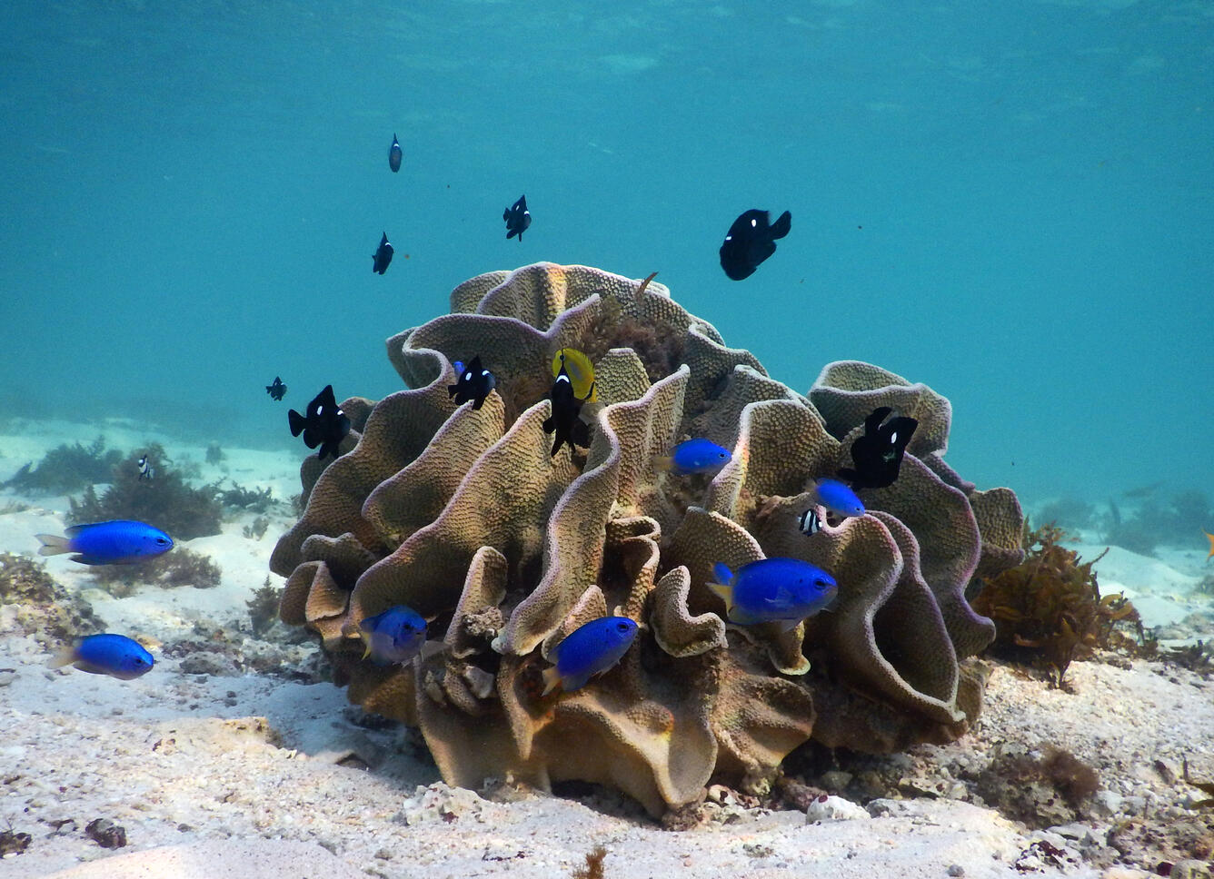
Cerulean damselfish dart around lettuce coral off the Cape Range National Park along the Ningaloo Coast in Western Australia. USGS researchers combined forces with Australian colleagues in this UNESCO World Heritage Site to conduct the most extensive study of how erosion of reefs contribute sand to the beaches—a coast’s natural armor. With the threat of a rising sea and changes to the climate, understanding this connection can tell us how resilient the coast will be. Coral reefs are unique ecosystems of plants, animals, and their associated geological framework. Coral reefs cover less than 0.5 percent of the earth's surface, but are home to an estimated 25 percent of all marine species. Second only to tropical rainforests in size and complexity, some scientists estimate that more than one million species of plants and animals are associated with coral reefs. Coral reefs are also of great economic importance to those who live on or visit islands in the Pacific and Atlantic Oceans. Reefs shelter and provide nursery grounds for many commercially and culturally important species of fish and invertebrates, they protect the islands' harbors, beaches, and shorelines from erosion and wave damage by storms, and they are vital to the marine tourism industry. These diverse ecosystems provide valuable goods and services worth about $4 billion each year to the U.S.’s coastal communities. Yet, as important as coral reefs are, these ecosystems are being threatened worldwide.
More than 8,500 square miles (22,000 square kilometers) of coral reef habitat is found in U.S. waters. Most of these coral reefs still appear to be relatively healthy, but some areas of dead and dying coral have been found in recent years. The causes of this degradation are poorly known, but are probably in part related to human activities.
Waves breaking over the fringing coral reef that protects the shoreline of Waikīkī and infrastructure of Hawaiʻi's capital, Honolulu. The U.S. Geological Survey (USGS), working closely with academic institutions, state, and other Federal agencies, is spearheading an effort to better understand the geologic and oceanographic controls on the structure and processes of our Nation's coral reef ecosystems.
This web site is a gateway to USGS studies of coral reefs. We focus on the geophysical processes that influence the health and sustainability of coral reefs. From this work we are gaining new insight into the structure of coral reefs, providing the basis for future monitoring, and understanding better both the influences of natural processes and impacts of human activities on coral reef health. These efforts will help to preserve and protect the biodiversity, health, and social and economic value of these remarkable habitats.
Read more coral reef facts.
Underwater photograph off Molokaʻi Hawaiʻi, showing some of the impacts of land-based pollution, such as terrestrial sediment, on coral reefs: burial by sediment, algal overgrowth, and coral bleaching. Learn about our current studies by topic.
Climate Change and Land-use Histories
We are developing new and unique oceanographic and environmental archives from coral skeleton records to better understand the compounding effects of land-use and environmental change on coral reef health.
We are conducting geophysical and geochemical research to address questions about coastal groundwater-to-reef flow and coral reef health, with the goal of informing management decisions related to planning and implementing activities in priority watershed-coral reef systems.
Reef Hydrodynamics and Sediment Processes
We are developing a better understanding how tides, waves, currents, and both land- and reef-derived sediment influence the development of coral reefs and their adjacent shorelines.
Role of Reefs in Coastal Protection
We are combining ocean, engineering, ecologic, social, and economic modeling to provide a high-resolution, rigorous, spatially-explicit valuation of the coastal flood protection benefits provided by coral reefs and the cost effectiveness of reef restoration for enhancing those benefits.
Reef Resource Assessments - Planning for the Future
We are mapping and assessing all of the important geologic and oceanographic factors to identify those coral reefs most at risk and those reefs that are potentially the most resilient and the most likely to recover from natural and human-driven impacts.
Also, learn about our studies by location:
- Guam
- Hawai‛i
- Kaho‛olawe
- Kaua‛i
- Kwajalein Island
- Lāna‛i
- Maui
- Moloka‛i
- O‛ahu
- Puerto Rico
- Roi-Namur Island
- Tutuila
Please also see the associated Coral Reef Ecosystem Studies (CREST) Project website.
Our partners are numerous and include:
- U.S. Coral Reef Task Force (USCRTF)
- Department of the Interior
- Other Federal Partners
- State Partners
- Territorial and Commonwealth Partners
- Guam Division of Aquatic and Wildlife Resources
- Commonwealth of the Northern Mariana Islands Department of Land and Natural Resources
- American Samoa Department of Marine and Wildlife Resources
- Puerto Rico Department of Natural and Environmental Resources
- U.S. Virgin Islands Department of Planning and Natural Resources
- Academia
- University of California Santa Cruz - Institute of Marine Sciences
- University of Western Australia - Oceans Institute
- University of Puerto Rico at Mayaguez - Center for Applied Ocean Science & Engineering
- University of Hawaiʻi - Hawaiʻi Institute of Marine Biology
- Woods Hole Oceanographic Institution - Department of Geology and Geophysics
- Delft University of Technology - Department of Hydraulic Engineering
- Queen's University - Department of Civil Engineering
- University of Cantabria - Department of Sciences and Techniques in Water and Environment
- Non-governmental Organizations
- Science
Below are the current studies and study locations of the USGS Coral Reef Project. Please also see the associated Coral Reef Ecosystem Studies (CREST) Project website.
Filter Total Items: 23Coral Reef Project: Molokaʻi
As part of the USGS Coral Reef Project, recent USGS work on Molokaʻi includes looking into the coral record to find clues to past sedimentation events.Role of Reefs in Coastal Protection
We are combining ocean, engineering, ecologic, social, and economic modeling to provide a high-resolution, rigorous, spatially-explicit valuation of the coastal flood protection benefits provided by coral reefs and the cost effectiveness of reef restoration for enhancing those benefits.Reef Resource Assessments - Planning for the Future
We are mapping and assessing all of the important geologic and oceanographic factors to identify those coral reefs most at risk and those reefs that are potentially the most resilient and the most likely to recover from natural and human-driven impacts.Quantifying Flood Risk and Reef Risk Reduction Benefits in Florida and Puerto Rico: The Consequences of Hurricane Damage, Long-term Degradation, and Restoration Opportunities
Coastal flooding and erosion from extreme weather events affect thousands of vulnerable coastal communities; the impacts of coastal flooding are predicted to worsen during this century because of population growth and climate change. Hurricanes Irma and Maria in 2017 were particularly devasting to humans and natural communities. The coral reefs off the State of Florida and the Commonwealth of...The Value of U.S. Coral Reefs for Risk Reduction
Summary of the report, “Rigorously valuing the role of U.S. coral reefs in coastal hazard risk reduction”
Climate Change and Land-use Histories
We are developing new and unique oceanographic and environmental archives from coral skeleton records to better understand the compounding effects of land-use and environmental change on coral reef health.Coral Reef Project: Kauaʻi
As part of the USGS Coral Reef Project, the USGS is working on the island of Kauaʻi to identify circulation patterns and a sediment budget for Hanalei Bay to help determine any effects to the coastal marine ecosystem.Coral Reef Project: Puerto Rico
To better understand how waves move across coral reefs and cause flooding on tropical shorelines, USGS scientists have installed video cameras and oceanographic instruments off San Juan and Rincón, Puerto Rico. Their work is part of a study funded by USGS after Hurricanes Irma and María. The offshore instruments measure wave heights and speeds; the onshore video cameras show where waves break on...Reef Hydrodynamics and Sediment Processes
The overall objective of this research effort is to better understand how circulation and sediment processes impact coral reefs and their adjacent coastlines.Coral Reef Project: Maui
As part of USGS Coral Reef Project studies, the USGS has been heavily involved in efforts to improve the health and resilience of Maui's coral reef system, bringing expertise in mapping, circulation and sediment studies, and seismic surveys.Low-lying areas of tropical Pacific islands
Sea level is rising faster than projected in the western Pacific, so understanding how wave-driven coastal flooding will affect inhabited, low-lying islands—most notably, the familiar ring-shaped atolls—as well as the low-elevation areas of high islands in the Pacific Ocean, is critical for decision-makers in protecting infrastructure or relocating resources and people.Coral Reef Project: Oʻahu
As part of the Coral Reef Project, the USGS is working closely with other local groups to investigate poor water quality issues in Maunalua Bay on the southeast coast of Oʻahu. - Data
Below are data releases associated with this project.
Filter Total Items: 21Aerial imagery and structure-from-motion-derived shallow water bathymetry from a UAS survey of the coral reef off Waiakane, Molokai, Hawaii, June 2018
An unoccupied aerial system (UAS) was used to acquire high-resolution imagery of the shallow fringing coral reef at Waiakane, Molokai, Hawaii, on 24 June 2018. Imagery was acquired over an area between the shoreline and approximately 900 meters offshore, covering approximately 16 hectares. The imagery was processed using structure-from-motion (SfM) photogrammetric techniques with additional refracProjected flooding extents and depths based on 10-, 50-, 100-, and 500-year wave-energy return periods for the State of Florida and the Commonwealth of Puerto Rico before and after Hurricanes Irma and Maria due to the storms' damage to the coral reefs
This data release provides flooding extent polygons based on wave-driven total water levels for the coral lined coast of Florida and the Commonwealth of Puerto Rico. The wave and sea-level conditions were then propagated using the XBeach over 100-m spaced shore-normal transects modified to account for base and post-storm scenarios. In situ observations following hurricanes Irma and Maria were usedProjected flooding extents and depths based on 10-, 50-, 100-, and 500-year wave-energy return periods for the State of Florida, the Commonwealth of Puerto Rico, and the Territory of the U.S. Virgin Islands for current and potentially restored coral reefs
This data release provides flooding extent polygons based on wave-driven total water levels for the coral lined coasts of Florida, Puerto Rico, and the U.S. Virgin Islands. The locations of the restoration lines along and across shore were defined by the presence of continuous coral/hardbottom habitat of greater than 100 m alongshore length and proximity to the 3-m depth contour. The wave and seaCoral geochemistry time series from Kahekili, west Maui
Geochemical analysis (including stable boron, boron:calcium ratio, and carbon and oxygen isotopes) were measured from coral cores collected in July 2013 from the shallow reef at Kahekili in Kaanapali, west Maui, Hawaii from scleractinian Porites lobata.Model parameter input files to compare locations of coral reef restoration on different reef profiles to reduce coastal flooding
This dataset consists of physics-based XBeach Non-hydrostatic hydrodynamic models input files used to study how coral reef restoration affects waves and wave-driven water levels over coral reefs, and the resulting wave-driven runup on the adjacent shoreline. Coral reefs are effective natural coastal flood barriers that protect adjacent communities. Coral degradation compromises the coastal protectCross-reef wave and water level data from coral reef environments
Coral reefs provide important protection for tropical coastlines against the impact of large waves and storm damage by energy dissipation through wave breaking and bottom friction. However, climate change and sea level rise have led to growing concern for how the hydrodynamics across these reefs will evolve and whether these changes will leave tropical coastlines more vulnerable to large wave evenJurabi, Exmouth, Western Australia, 2016 Coral Reef Circulation and Sediment Dynamics Experiment
Carbonate reefs are a major source of sediment for coastlines in much of the tropical regions of the world, contributing to significant shoreline accretion and beach nourishment. A collaborative experiment between the U.S. Geological Survey and the University of Western Australia was conducted on Ningaloo Reef, northwest Australia, to investigate this problem and determine the primary oceanographiDatabase to model three-dimensional flow over coral reef spur-and-groove morphology
This data set consists of physics-based Delft3D-FLOW and SWAN hydrodynamic models input files used to study the wave-induced 3D flow over spur-and-groove (SAG) formations. SAG are a common and impressive characteristic of coral reefs. They are composed of a series of submerged shore-normal coral ridges (spurs) separated by shore-normal patches of sediment (grooves) on the fore reef of coral reef eModeled effects of depth and semidiurnal temperature fluctuations on predictions of year that coral reef locations reach annual severe bleaching for various global climate model projections
Using global climate model projections of sea-surface temperature at coral reef sites, we modeled the effects of depth and exposure to semidiurnal temperature fluctuations to examine how these effects may alter the projected year of annual severe bleaching for coral reef sites globally. Here we present the first global maps of the effects these processes have on bleaching projections for three IPCCoral reef profiles for wave-runup prediction
This data release includes representative cluster profiles (RCPs) from a large (>24,000) selection of coral reef topobathymetric cross-shore profiles (Scott and others, 2020). We used statistics, machine learning, and numerical modelling to develop the set of RCPs, which can be used to accurately represent the shoreline hydrodynamics of a large variety of coral reef-lined coasts around the globModel parameter input files to compare wave-averaged versus wave-resolving XBeach coastal flooding models for coral reef-lined coasts
This data release includes the XBeach input data files used to evaluate the importance of explicitly modeling sea-swell waves for runup. This was examined using a 2D XBeach short wave-averaged (surfbeat, XB-SB) and a wave-resolving (non-hydrostatic, XB-NH) model of Roi-Namur Island on Kwajalein Atoll in the Republic of Marshall Islands. Results show that explicitly modelling the sea-swell componenDynamically downscaled future wave projections from SWAN model results for the main Hawaiian Islands
Projected wave climate trends from WAVEWATCH3 model output were used as input for nearshore wave models (for example, SWAN) for the main Hawaiian Islands to derive data and statistical measures (mean and top 5 percent values) of wave height, wave period, and wave direction for the recent past (1996-2005) and future projections (2026-2045 and 2085-2100). Three-hourly global climate model (GCM) wind - Multimedia
- Publications
Below is a list of our project publications.
Filter Total Items: 158Human and ecosystem health in coastal systems
U.S. coastal economies and communities are facing an unprecedented and growing number of impacts to coastal ecosystems including beach and fishery closures, harmful algal blooms, loss of critical habitat, as well as shoreline damage. This paper synthesizes our present understanding of the dynamics of human and ecosystem health in coastal systems with a focus on the need to better understand nearshAction plan for restoration of coral reef coastal protection services: Case study example and workbook
This report was prepared by the U.S. Environmental Protection Agency (USEPA), Office of Research and Development, as part of the Air, Climate and Energy (ACE) research program, with support from Tetra Tech, Inc., and in collaboration with the National Oceanic and Atmospheric Administration, the U.S. Geological Survey, and The Nature Conservancy. The ACE research program provides scientific informaRigorously valuing the impact of Hurricanes Irma and Maria on coastal hazard risks in Florida and Puerto Rico
The degradation of coastal habitats, particularly coral reefs, raises risks by increasing the exposure of coastal communities to flooding hazards. In the United States, the physical protective services provided by coral reefs were recently assessed in social and economic terms, with the annual protection provided by U.S. coral reefs off the coasts of the State of Florida and the Commonwealth of PuRigorously valuing the coastal hazard risks reduction provided by potential coral reef restoration in Florida and Puerto Rico
The restoration of coastal habitats, particularly coral reefs, can reduce risks by decreasing the exposure of coastal communities to flooding hazards. In the United States, the protective services provided by coral reefs were recently assessed in social and economic terms, with the annual protection provided by U.S. coral reefs off the coasts of the State of Florida and the Commonwealth of PuertoRigorously valuing the impact of projected coral reef degradation on coastal hazard risk in Florida
The degradation of coastal habitats, particularly coral reefs, raises risks by increasing the exposure of coastal communities to flooding hazards. In the United States, the physical protective services provided by coral reefs were recently assessed, in social and economic terms, with the annual protection provided by U.S. coral reefs off the coast of the State of Florida estimated to be more thanRebounds, regresses, and recovery: A 15-year study of the coral reef community at Pila‘a, Kaua‘i after decades of natural and anthropogenic stress events
Pila‘a reef on the north shore of Kaua‘i, Hawai‘i was subjected to a major flood event in 2001 that deposited extensive sediment on the reef flat, resulting in high coral mortality. To document potential recovery, this study replicated benthic and sediment surveys conducted immediately following the event and 15 years later. Coral cores were analyzed to determine coral growth rates and density. OuBomb-produced radiocarbon across the South Pacific Gyre — A new record from American Samoa with utility for fisheries science
Coral skeletal structures can provide a robust record of nuclear bomb produced 14C with valuable insight into air-sea exchange processes and water movement with applications to fisheries science. To expand these records in the South Pacific, a coral core from Tutuila Island, American Samoa was dated with density band counting covering a 59-yr period (1953–2012). Seasonal signals in elemental ratioLand-based sediment sources and transport to southwest Puerto Rico coral reefs after Hurricane Maria, May 2017 to June 2018
The effects of runoff from land on nearshore ecosystems, including coral reef communities, are influenced by both sediment supply and removal by coastal processes. Integrated studies across the land-sea interface describing sources and transport of terrestrial sediment and its nearshore fate allow reef protection initiatives to target key onshore and offshore areas. Geochemical signatures in the fOnline-coupling of widely-ranged timescales to model coral reef development
The increasing pressure on Earth's ecosystems due to climate change is becoming more and more evident and the impacts of climate change are especially visible on coral reefs. Understanding how climate change interacts with the physical environment of reefs to impact coral growth and reef development is critically important to predicting the persistence of reefs into the future. In this study, a biWave-driven flood-forecasting on reef-lined coasts early warning system (WaveFoRCE)
Increasing the resilience of coastal communities while decreasing the risk to them are key to the continued inhabitance and sustainability of these areas. Low-lying coral reef-lined islands are experiencing storm wave-driven flood events that currently strike with little to no warning. These events are occurring more frequently and with increasing severity. There is a need along the world’s coralCoral reef restorations can be optimized to reduce coastal flooding hazards
Coral reefs are effective natural coastal flood barriers that protect adjacent communities. Coral degradation compromises the coastal protection value of reefs while also reducing their other ecosystem services, making them a target for restoration. Here we provide a physics-based evaluation of how coral restoration can reduce coastal flooding for various types of reefs. Wave-driven flooding reducThe value of US coral reefs for flood risk reduction
Habitats, such as coral reefs, can mitigate increasing flood damages through coastal protection services. We provide a fine-scale, national valuation of the flood risk reduction benefits of coral habitats to people, property, economies and infrastructure. Across 3,100 km of US coastline, the top-most 1 m of coral reefs prevents the 100-yr flood from growing by 23% (113 km2), avoiding flooding to 5 - Web Tools
The Role of U.S. Coral Reefs in Coastal Protection
U.S. Geological Survey scientists have shown that along with providing food, tourism, and biodiversity, coral reefs also protect dollars and lives. This interactive geonarrative introduces the USGS research to understand the role of US coral reefs in coastal protection.
- News
Below are news stories associated with this project.
Filter Total Items: 15 - Partners
USGS Investigations of coral reefs are cooperative efforts, and our scientists are working in partnership and cooperation with the following organizations.
Filter Total Items: 23