
Transboundary Water Quality Monitoring in Washington State
The USGS is monitoring the water quality of rivers that cross the U.S.-Canadian border. In Washington State, our focus is on the Upper Skagit and Similkameen watersheds. Intensive monitoring began in 2019, and the data we collect helps us understand current conditions and detect long-term changes in water quality.
Shared Waters
The USGS is engaged in a transboundary water quality monitoring program, motivated by a shared desire to support human and ecological health. Rivers that flow between the U.S. and Canada are critical for culturally and economically significant fisheries, and they provide water for communities in both nations. By monitoring and evaluating baseline conditions, we support management of water quality in these rivers.
Changes in upstream land management, such as increased mining, logging, and road construction in British Columbia, could potentially affect the water quality of rivers flowing into Washington. The USGS focuses monitoring efforts on the upper Skagit and Similkameen Rivers due to historical, ongoing, and planned mining activities in these watersheds. By measuring water quality before land use changes take place, we can track trends and assess any impacts on water quality.
Learn more about the USGS Transboundary Program
Transboundary Watersheds Geonarrative
Program Overview
Objectives
The main goal of this project is to collect water quality data from rivers that cross the U.S. – Canada border. This data will help us evaluate current watershed conditions and identify long-term changes in water quality.
Title
Click the map features to learn more about the two watersheds where the USGS Washington is monitoring transboundary water quality.
Monitoring Activities in Washington
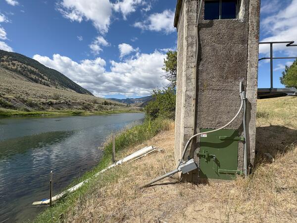
In Washington state, we gather water quality data from four monitoring sites—two on the Skagit River and two on the Similkameen River. Some of the sites provide continuous data, recording how parameters such as pH and temperature change through time. Additionally, our technicians visit nearby sites about six times a year to collect more detailed information, provided as discrete data. Water samples are analyzed for metals and nutrients.
Annually, USGS researchers also study food webs and aquatic life. We collect samples of fish, freshwater mussels, snails, algae, and sediment, focusing on the presence of metals. These analyses help us understand how aquatic communities are changing, as well as how contaminants move through the food web.
The table below lists the types of water quality data available at each monitoring site and includes links to access this data via the USGS Water Data for the Nation web service.
| USGS Site Number | USGS Monitoring Site Name & Link | Watershed | Type of collected data |
| 12442500 | Similkameen River near Nighthawk, WA | Similkameen | Continuous |
| 485802119383200 | Similkameen R-4.5 | Similkameen | Discrete |
| 12170350 | Skagit River above Klesilkwa River near Hope, BC | Skagit | Continuous |
| 485955121042501 | Ross Lake – near Canadian Border | Skagit | Discrete |
Explore related USGS efforts across the Pacific Northwest.

Transboundary Assessments of Water Quality in the Pacific Northwest

Assessing the effects of mining on the Transboundary Koocanusa Reservoir

USGS Transboundary River Monitoring in Southeast Alaska

Monitoring Mining Effects in the Kootenai River Watershed
The USGS is monitoring the water quality of rivers that cross the U.S.-Canadian border. In Washington State, our focus is on the Upper Skagit and Similkameen watersheds. Intensive monitoring began in 2019, and the data we collect helps us understand current conditions and detect long-term changes in water quality.
Shared Waters
The USGS is engaged in a transboundary water quality monitoring program, motivated by a shared desire to support human and ecological health. Rivers that flow between the U.S. and Canada are critical for culturally and economically significant fisheries, and they provide water for communities in both nations. By monitoring and evaluating baseline conditions, we support management of water quality in these rivers.
Changes in upstream land management, such as increased mining, logging, and road construction in British Columbia, could potentially affect the water quality of rivers flowing into Washington. The USGS focuses monitoring efforts on the upper Skagit and Similkameen Rivers due to historical, ongoing, and planned mining activities in these watersheds. By measuring water quality before land use changes take place, we can track trends and assess any impacts on water quality.
Learn more about the USGS Transboundary Program
Transboundary Watersheds Geonarrative
Program Overview
Objectives
The main goal of this project is to collect water quality data from rivers that cross the U.S. – Canada border. This data will help us evaluate current watershed conditions and identify long-term changes in water quality.
Title
Click the map features to learn more about the two watersheds where the USGS Washington is monitoring transboundary water quality.
Monitoring Activities in Washington
In Washington state, we gather water quality data from four monitoring sites—two on the Skagit River and two on the Similkameen River. Some of the sites provide continuous data, recording how parameters such as pH and temperature change through time. Additionally, our technicians visit nearby sites about six times a year to collect more detailed information, provided as discrete data. Water samples are analyzed for metals and nutrients.
Annually, USGS researchers also study food webs and aquatic life. We collect samples of fish, freshwater mussels, snails, algae, and sediment, focusing on the presence of metals. These analyses help us understand how aquatic communities are changing, as well as how contaminants move through the food web.
The table below lists the types of water quality data available at each monitoring site and includes links to access this data via the USGS Water Data for the Nation web service.
| USGS Site Number | USGS Monitoring Site Name & Link | Watershed | Type of collected data |
| 12442500 | Similkameen River near Nighthawk, WA | Similkameen | Continuous |
| 485802119383200 | Similkameen R-4.5 | Similkameen | Discrete |
| 12170350 | Skagit River above Klesilkwa River near Hope, BC | Skagit | Continuous |
| 485955121042501 | Ross Lake – near Canadian Border | Skagit | Discrete |
Explore related USGS efforts across the Pacific Northwest.
Transboundary Assessments of Water Quality in the Pacific Northwest
Assessing the effects of mining on the Transboundary Koocanusa Reservoir
USGS Transboundary River Monitoring in Southeast Alaska